Cyclones and Bella Vistas

Creek

Leafy Streams (click image for a slideshow)

Have you ever had a 2000-acre state park all to yourself?  I did on a warm Saturday afternoon in early November, visiting a place where some of my ancestors had bitter experiences in the Civil War.

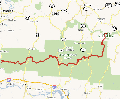
Earlier in the week I was perusing my new Hiking Missouri book, looking for something not too far from Bartlesville.  I came across the Ozark Chinquapin Trail at Big Sugar Creek State Park in McDonald County, just west of Barry County where I’ve spent countless vacations since childhood.  I’d never heard of this park, so I looked it up in Google Maps and was shocked to see that it’s adjacent to Cyclone, Missouri.  That place brings forth tales of death and hardship in my family, but not from the tornado that gave the place its name in the late 1800s.

My Ancestors at Big Sugar Creek

Cyclone is nothing more than a low-water crossing and a couple of houses these days, and did not even exist when my great-great-grandfather bought an 80-acre farm just northeast of there in 1851 on a bend of Big Sugar Creek.  He and his wife and children built a milldam and grist mill, using the open range to graze their cattle.  My great-grandfather was born there in 1856, and his mother died in childbirth the following year.  She and her infant are buried there on the farm, which today is the eastern part of the largely undeveloped Big Sugar Creek State Park.  My father located their graves, marked only by fieldstones, in the years before the land was acquired for the park.

After losing his wife, my great-great-grandfather remarried and had another daughter.  But the Civil War would bring a tragic end to their life on Big Sugar Creek.  My great-grandfather recalled how Confederate troops who were stationed in the county in the winter of 1860 through the spring of 1861 drove up in their provision wagons, shot the family’s cattle, hogs, and sheep, loaded them up, and drove away.  Limestone bluffs across the creek from the family farm allowed soldiers to establish a picket line and hold prisoners in that bend of the creek, so it became known as Penitentiary Bottom.

My great-great-grandfather and his two eldest sons joined the Union army in 1862, but someone stole his overcoat and he died of pneumonia in Cassville in late May after only two months of service.  His second wife left for Kansas with their young daughter and the two eldest sons were still in the Union army, so that left six orphans alone at the farm on Big Sugar Creek.  They ranged in age from a 17-year-old daughter to my great-grandfather, who was the youngest at age six.

The six orphans had only two scrubby work steers left, so they made a box bed to mount on the front axle of a wagon, loaded what few belongings they had left, and traveled fifty miles to Lawrence County, where they lived in a cabin that had formerly been used for farm slaves.  My great-grandfather remembered how they had little more than corn bread to eat and he would cry from hunger after going to bed.  There was a small lake nearby where soldiers would come to wash their clothes, and the only shoes my great-grandfather and his siblings had were old shoes the soldiers had thrown away at that lake.

With all of that family history swirling through my head, it was clear that my next day hike would be at Big Sugar Creek.  So Saturday morning I dashed back out along US 60 and I-44 to Joplin.  I could have turned off at Afton for lunch at Neosho, but my last lunch there was unimpressive and I had a hankering for the wood-fire pizza Yelp recommended in Joplin.  I’ve never explored that ugly town very much, so it was interesting to head downtown to old highway 66, where I would turn east for the pizza paradise.  I’d left Bartlesville at 9 am since it was supposedly two hours to Joplin.  But I got to town early, which was just as well, since I got stuck in traffic downtown for 20 minutes waiting for the Joplin Veterans Day’s Parade to pass by.

When I finally reached my goal, I found a tiny restaurant with no cars in a blighted area.  No thanks, Yelp!  So I reluctantly drove back east to pizza choice number two, knowing it was situated, like so many other restaurants, along Joplin’s hideous Range Line Road.  I had the buffet, which helps explain why my lunch consisted of salad, pizza, and, er, a cinnamon roll.  Pizza parlor desserts tend to be a bit strange, don’t they?

Then I rocketed down the new US 71, which has been rebuilt to interstate standards.  At 70 mph it wasn’t long until I reached Pineville, where I turned off onto the narrow asphalt of Big Sugar Creek Road and meandered twelve miles east to lonely Cyclone.  The water was up over the low-water bridge, so I asked a couple at the nearby house what my other options might be.  They assured me I could drive across safely.  “Drive ‘er slow and down the middle, and you’ll make it just fine.”

So I reluctantly drove across it eastward, with water gurgling beneath the floorboards.  The road on the other side was gravel and it was a short drive uphill to the north to reach the entrance to the old Meador farm.  The state bought this area in the 1990s but has not developed much in the park.  There is just the hiking trail over in the western portion, and this eastern portion has an abandoned 1950s homestead.  As was the case years ago when my parents last visited Cyclone, the gate was padlocked.  This time it had a notice that this is a closed portion of the state park.  I considered jumping the fence, but decided it was best to follow the rules and forgo finding the grave of my great-great-grandmother.  This park is administered over at Roaring River, so maybe I’ll ask there sometime for permission.

Returning to the low water crossing, I saw the walls and gears from the old grist and sawmill that was built there in the late 1800s.  Gurgling my way back across, I drove to the Ozark Chinquapin Trail.  A couple finishing their hike were just leaving as I arrived at the trailhead, which has two vault toilets.  Nearby is an old stone outbuilding for the former Shady Grove School.  I had the trail, and thus the entire park, to myself for the rest of my stay.

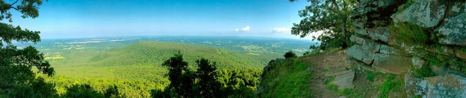
The three-mile loop trail’s eastern leg meanders north back and forth along a limestone streambed with one section of lumpy limestone bedrock reminiscent of Roaring River’s Dry Hollow.  Much of this portion was dry on this 77-degree November day, but there was one little active stream with pleasant rippling water.  Some of the ridges along there were so eroded they resembled giant gravel piles.  (Reminds one of Joplin’s sinkholes and tailings from years of lead and zinc mining.)  My scuffling along the leafy trail spooked a white-tail deer away from the stream and up the slope.  As the trail looped around on the north, it ran along the side of a wooded hill.  There I saw an interesting hollow tree and meandered off trail to reach a truly strange tree.

Then it was back down the streambed of the western leg.  Here the water had carved out a small natural amphitheater and flooded it, with lovely ripples and shadows and floating autumn leaves.  This stream had carved deeper through the limestone layers.  With no one about, I set up my Gorillapod for a self-portrait.  Near the end of the hike, I spied something odd in the streambed.  It looked like a piece of sidewalk embedded in a tree.  A closer look showed that a chunk of limestone had crashed downstream or out of the side of the streambed in a flood, embedding in a tree that valiantly grew around it.

Arriving back at the trailhead, I stripped off my shirt and washed up.  I never expected to be this warm in November!  Freshened up, I drove back to US 71 and rocketed down to Bella Vista, Arkansas.  This golfers’ paradise has now incorporated, although one’s impression is still a series of golf courses surrounded by retirement homes and interspersed with box stores and strip malls.  But it beats Joplin’s Range Line!

I drove into the heart of “town”, which looks like a dendritic forest on the map.  There behind the dam at Lake Windsor is the Tanyard Creek Nature Trail.  Volunteers constructed this trail, which wraps around the namesake creek with nice bluffs and drip walls, a small cave with an ugly tin cover over its entrance (that part was simply too ugly for a snapshot), and some impressive rocks.  The trails are dotted with innumerable signposts identifying trees and natural formations.  True to form, I ignored almost all of them.  Walking by so many such posts reminds one of driving by mile markers on the Turner Turnpike.  But the creek below the Lake Windsor spillway is quite pretty, although malodorous.

I would have liked to photograph the small waterfall there as well, but a family was hogging the cramped viewing area, blithely ignoring the rules about walking past the fence so they could take snapshots by the falls with their cell phones.  What a contrast to my own refusal to break the rules and enter a closed section of an absolutely empty state park to go see my ancestor’s grave.  It takes all types!

Trudging back to the car, I took one last snapshot of the rushing water as dusk closed in.  After the Yelp failure at lunch, I wondered how dinner would go.  But Urbanspoon’s recommendation of Las Fajitas was accurate.  The place was packed, the food was tasty, and I liked their brightly painted tabletops and booth backs.  It was a quick roll back to Bartlesville.  In fact, I spent far more time downloading photos from a friend’s borrowed camera, editing and posting them, and writing this post than I did driving back to Bartlesville from another successful day hike.

Click for a photo slideshow from this day trip

Posted in day hike, photos, travel | 1 Comment

The Pale Blue Dot That Always Makes Me Cry

pbdThe other day I had to choke back the tears in class again, for I always break down when I mention Carl Sagan and the Pale Blue Dot.

Carl was a great popularizer of science and astronomy, perhaps best known for his inimitable way of saying “billions” where he always emphasized the b.  His PBS television series Cosmos influenced me greatly with its spectacular scope and vision.  [At this writing, you can view Cosmos on hulu.com!]

I loved his books, especially Broca’s Brain: Reflections on the Romance of Science, The Dragons of Eden: Speculations on the Evolution of Human Intelligence, and the “baloney detection kit” from his The Demon-Haunted World: Science as a Candle in the Dark.  He was a great agnostic skeptic of tremendous eloquence and sincerity.  I love how he convinced NASA to put messages on the Pioneer and Voyager probes that would be leaving our solar system.  Messages that could, in some distant future, possibly be found by aliens and be a remembrance of our civilization.

But the Pale Blue Dot always makes me cry.  Sagan convinced NASA to have Voyager 1, as it exited the solar system in 1990, turn its view back toward the sun and snap one last photo of our planet.  Earth showed up as a pale blue dot – a single pixel in the grainy image.  Sagan capitalized on the power of that symbol in a commencement address he gave in 1996 a few months before his death:

Look again at that dot. That’s here. That’s home. That’s us. On it everyone you love, everyone you know, everyone you ever heard of, every human being who ever was, lived out their lives. The aggregate of our joy and suffering, thousands of confident religions, ideologies, and economic doctrines, every hunter and forager, every hero and coward, every creator and destroyer of civilization, every king and peasant, every young couple in love, every mother and father, hopeful child, inventor and explorer, every teacher of morals, every corrupt politician, every “superstar,” every “supreme leader,” every saint and sinner in the history of our species lived there – on a mote of dust suspended in a sunbeam.

The Earth is a very small stage in a vast cosmic arena. Think of the rivers of blood spilled by all those generals and emperors so that, in glory and triumph, they could become the momentary masters of a fraction of a dot. Think of the endless cruelties visited by the inhabitants of one corner of this pixel on the scarcely distinguishable inhabitants of some other corner, how frequent their misunderstandings, how eager they are to kill one another, how fervent their hatreds.

Our posturings, our imagined self-importance, the delusion that we have some privileged position in the Universe, are challenged by this point of pale light. Our planet is a lonely speck in the great enveloping cosmic dark. In our obscurity, in all this vastness, there is no hint that help will come from elsewhere to save us from ourselves.

The Earth is the only world known so far to harbor life. There is nowhere else, at least in the near future, to which our species could migrate. Visit, yes. Settle, not yet. Like it or not, for the moment the Earth is where we make our stand.

It has been said that astronomy is a humbling and character-building experience. There is perhaps no better demonstration of the folly of human conceits than this distant image of our tiny world. To me, it underscores our responsibility to deal more kindly with one another, and to preserve and cherish the pale blue dot, the only home we’ve ever known.

Thanks, Carl, for the Pale Blue Dot, even though it always make me cry.

Posted in physics | 2 Comments

On the Rim of White Rock Mountain

October 25, 2009

Atop White Rock Mountain (click image for a slideshow)

Atop White Rock Mountain (click image for a slideshow)


A sunny Saturday in late October was ideal for a day trip to the Ozarks for some fall foliage.  I recently purchased several hiking guides for Missouri and Arkansas and they agreed that some of the most spectacular vistas in the Ozarks are to be found on the rim of White Rock Mountain northeast of Fort Smith and Van Buren, Arkansas.  So I was off!

After a yummy Eggbert’s Bartlesville breakfast I stopped by a gas station to air up the tires.  They are worn out and I knew I’d be on remote gravel roads today, so I made sure to air up the spare tire as well.  Then I shot down US 75 and the Muskogee Turnpike, then east on Interstate 40 to Van Buren, Arkansas.  Just across the Arkansas River from Fort Smith, Van Buren is about 2/3 the size of Bartlesville.  I drove to its historic downtown and ordered a salad and “Ultimate” grilled cheese sandwich at the Sisters Gourmet Bistro.  By the time I was finished, my mouth was burning.  Alas, too late did I realize that the Ultimate grilled cheese is served on jalapeno bread.

The big tourist attraction in downtown Van Buren is the excursion train of the Arkansas & Missouri Railroad which runs from Ft. Smith up to Springdale through the Boston Mountains, an extension of the Ozarks.  After lunch I noticed one had pulled in, attracting a crowd waiting to board.  The best train ride I’ve ever had was with my dad years ago aboard the narrow-gauge steam train between Durango and Silverton, Colorado with its spectacular scenery that reminds one of many an old western movie.  While I doubt the Boston Mountains can compete, I’m certain that ride is far more scenic than what I saw the time I suffered on an excursion train from Bartlesville to Ocheleta.

20 miles farther east on Interstate 40 brings one to Arkansas 215, which winds north to Shores Lake.  The reflections of the fall foliage in the water were quite nice, although that single snapshot cost me $3 since I dutifully paid the day use fee for the privilege of parking there for less than half an hour.  I didn’t notice any day use fee signs farther up on White Rock Mountain – perhaps they take pity on you for having driven 10 miles on gravel and dirt roads to reach the rim.

The Forest Service reports White Rock Mountain is “2,260 feet above sea level and received its name from the appearance of the lichen on the sheer bluffs that look white from a distance.”  The only worrisome spot on the road was toward the top where recent rains had made it a bit muddy, but even the worn-out tires on my Camry managed it easily.  After 10 miles of rough roads I must say I was glad to see the sign saying I’d made it and I was even more glad to see the foliage looked promising.

The CCC built a two-mile long trail around the rim along with a lodge, three cabins, and four shelters.  The most obvious is Sunset Shelter on the southwest corner of the rim, although I wasn’t going to stick around to enjoy the sunset from it.  The shelter has a 270-degree view of the countryside below and a low wall featuring chiseled mileage markers to nearby towns.  The autumn leaves accentuated the rolling hills and rocky outcroppings.  You can walk right out onto the high prominent ledges and one shelter had a sign banning rappelling since six people have died trying it up there.

After exhausting the views from Sunset Shelter I took the trail north up the west side of the rim past the smaller West Shelter and then on around to the North Shelter‘s views to the east.  The trail on the north rim was quite brushy due to a past fire but the southeast rim had impressive bluffs and a spring improved by the CCC.  The south rim has short side trails leading up to the cabins and lodge while its South Shelter is quite picturesque up on its promontory.

At the southeast corner of the rim is a trail down the mountainside to reach the Ozark Highlands Trail, which runs 165 miles across northeast Arkansas.  Part of that big trail is used to create a 13-mile loop trail between Shores Lake and the White Rock Mountain Rim Trail.  I took that side trail down the side of the mountain a short ways and the climb back up was a hot one, even in late October.  What a challenge that hike would be in mid-summer!

Four-wheelers zipped by me during my drive back down the mountain to Shores Lake.  Choking on their dust and fumes, I decided day hiking is friendlier.  By late afternoon I’d reached the Fort Smith Historic Site along the Arkansas River.  I was too late to tour the visitor center, but I enjoyed a short walk along the Arkansas River and did get a snapshot of one old cannon aimed out across the river and saw a reconstruction of the gallows where Judge Parker’s sentences were carried out.  During his tenure from 1875 to 1896, 79 men were hung there after being convicted in jury trials for committing rape or murder in western Arkansas and the Indian Territory.

My trip ended with dinner at the El Chico in Fort Smith and then a dash back to Bartlesville for some late-night photo editing and blogging.

Click for a photo slideshow from this day trip

Posted in day hike, photos, travel | 4 Comments

Four Drives and a Walk

I enjoyed my fall break of 2009, although I spent more time driving than hiking.

Drive One – Working at BHS

Thursday was my shortest driving day of the break by far, all of it in town!  I simply drove to Eggbert’s for breakfast and then spent the day wiring and rewiring classrooms at the high school, taking my lunch break at good old Pies and Such.  We are steadily working toward the goal of equipping each and every classroom with a ceiling projector hooked up to both a computer and a VCR/DVD player by 2011.  I was fixing wiring snafus left behind by various contractors.  ‘Tis a pity it is taking so long to get all of the classrooms up to snuff, but better late than never.

Coleman Theater

Coleman Theater (click image for slideshow)

Drive Two – Miami and Grove (slideshow available)

Day two was a day trip to Miami and Grove to some locations I found in my 7th edition of Off the Beaten Path: Oklahoma.  The first stop was the splendid Coleman Theater in Miami along historic route 66, a vaudeville theater and movie palace that has operated steadily since its opening in 1929.  George L. Coleman, Sr., a local mining magnate, built this structure with its Spanish Colonial Revival exterior and Louis XV interior.  He lavished about $600,000 on the theater.

Performers like Will Rogers, Bob Hope, Bing Crosby, and Cary Grant graced its stage, but the theater had hit hard times by the time the Coleman family donated it to the City of Miami in 1989.  Since then the community has worked steadily to restore and renovate the structure, using only private donations and no corporate sponsors.  They’ve fixed the beautiful statue in the mahogany paneled lobby, regilded some moldings with gold leaf, repainted elsewhere, and installed reproduction seats, although to accommodate today’s larger bottoms the seating capacity dropped from 1600 to about 1100!  They’ve restored the two-ton brass and crystal chandelier which can be lit in a wide variety of patterns and colors.  The Wurlitzer pipe organ, which had been sold to an evangelist for use in revivals, was repurchased from an organ collector and restored.  One of the stained glass ceiling lights was recovered from a Tulsa bar after the owner agreed to accept a reproduction in its stead. Even the ropes for the stage’s fly system were donated when a tourist whose family owned a rope company back east came through and recognized the need.

Tours are provided by volunteer docents from 10 am to 4 pm Tuesday-Friday and from 10 am to noon on Saturdays.  They’ve equipped the Wurlitzer with a recorder and player and the guide ran it through a thunderous rendition of Phantom of the Opera and Take Me Out to the Ball Game.  It was magnificent!  I also enjoyed how the rear of the theater has a “crying room” for upset children.  The theater is still in operation – I’m sorely tempted to drive over some day to take in a silent movie with pipe organ accompaniment.

After leaving the theater I had a dipped cone at Miami’s Ku Ku Drive-In.  This sole survivor of a chain that peaked at over 200 drive-ins across the midwest in the 1960s is owned and operated by Eugene Waylan, who has cooked at the place for over 40 years and owned it since the early 1970s.

I then drove over to Grove, crossed the Sailboat Bridge, and toured Lendonwood Gardens.  I’d noticed it before when driving to Har-Ber Village and decided to see what it looked like even though it could hardly be a showplace in mid-October.  A tame rabbit was chewing his way through the place while I took snapshots of flowers, roses, a caterpillar, the koi pond, and the Angel of Hope statue.  Then I drove back to Bartlesville for dinner.

Arcadia Round Barn

Arcadia Round Barn (click image for slideshow)

Drive Three – Arcadia (slideshow available)

Day three started with a drive down to Oklahoma City to see my parents.  We stuck with my Route 66 theme from the day before by driving out north to Edmond for yummy burgers and fries at Johnnie’s and then drove east on historic route 66 to visit Arcadia’s Pops 66 store and the famous Round Barn.  Pops opened a couple of years ago and is always busy.  Out front is a 66-foot high pop bottle sculpture that glows with neon colors at night.  The store has a popular restaurant, but I’ve never been willing to endure the wait.  I scanned the wall of coolers full of unusual sodas, but this time could not find my favorite Cherry Moxie.  So I settled for some Coca-Colas and Dr. Peppers made with real sugar instead of the usual corn syrup.  I took us out back to the grassy seating area where we snapped shots of me enjoying The Real Thing and Mom’s Dr. Pepper vs. Dad’s Coke.

Then we drove into Arcadia and toured the Round Barn, which dates back to 1898.  It was neglected for years and the 60′ diameter roof finally collapsed back in 1988.  But a retired building contractor and the Over the Hill Gang, a group of retirees, restored it over the next four years.  Today the first floor is a gift shop with oddball hand-lettered displays around the sides, while the second floor is a big open space where you can admire the basket-style roof design.

The Walk

That afternoon, after dropping my folks off back in Oklahoma City, I decided I had to get some sort of long walk in.  Back in high school a quarter-century ago I would sometimes go “parking” along the canal linking Lake Hefner and Lake Holdhercloser, er, I mean Overholser.  Back then I had stumbled across the beginnings of the Stinchcomb Wildlife Refuge, which is an undeveloped parcel along the North Canadian River.  The web claimed it had some trails, so I was off.

I parked on the east side near 50th street at a parking area that is still under development.  An old unpaved road runs north there along the river all the way over to the new Kilpatrick Turnpike.  I ambled along it, listening to another Hercule Poirot mystery, and took a few unmarked side trails to get a better glimpse of the river.  But recent rains had left much of the floodplain too muddy for my taste, so I mainly stuck to the river road.  I was hoping it would have a pedestrian bridge across the North Canadian so I could return along the west edge of the refuge, but no such luck.  Instead I had to simply reverse course back to the parking area.

I then followed a bike trail past the Bethany athletic fields down to, you guessed it, old route 66 once again.  I snapped some shots of the old bridge across the North Canadian, which runs along the north edge of Lake Overholser.  Its rusting superstructure now only bears the added weight of passing pedestrians.

A couple was enjoying the lake, setting up for a picnic at dusk.  I drove on down south past my old high school to the Lake Overholser dam.  The 1919 dam building looked almost grand in the light from the setting sun, and I was glad to note they tried to spruce up the aging dam back in 2004 with some spray-on concrete, although some of it is already spalling.

Drive Four – Lakes of Disappointment

Day four meant fall break was almost over, and I needed to drive back to Bartlesville.  Thinking I would get some more hiking in, I asked the web for trails along the route back home and opted for the Sand Plum trail, which stretches about 15 miles along the north shore of Keystone Lake near Prue.  Exiting the Turner Turnpike at Bristow, I drove up through Mannford south of the lake along some nice highways.  The highway 151 crossing over the Arkansas River towards Prue was closed, however, so I had to divert several miles east and cross on highway 97 in Sand Springs.  The Prue Road north of highway 64/412 rapidly deteriorated into a narrow patchy mess that reminded of how horrible highway 75 north of Bartlesville used to be in my youth.  This did not bode well.

Pulling into Walnut Creek State Park, I was struck by how empty it was.  All of the campsites had their restrooms closed for the winter and I only spotted two campers in the entire place.  I finally located the Sand Plum Trail, which only had an equestrian marker.  The trail was not too badly churned by horses and there weren’t too many “contributions” from those animals, but the trail itself was somewhat neglected and overgrown.  The west part of the trail petered out into a brambly mess.  Daunted but still willing, I then tried following the trail to the east, but again it was in poor shape and the lake views were anything but spectacular.  One prick too many from the brambles convinced me I’d be better off elsewhere.

So I decamped and followed my iPhone’s Google map northeast along county roads over to Skiatook Lake.  I’d only been out here once before.  A trip to a boat ramp revealed a short nature trail created by a local Boy Scout troop – the trail was short and easy and really only featured some signage which I didn’t want to read.  That makes three Oklahoma lakes I’ve visited this fall hoping for a good day hike only to be disappointed by shoddy maintenance.  Don’t bother hiking at Oologah, the north side of Keystone, or the parts I saw of Skiatook.  (I later found there is some sort of nature trail at Skiatook’s Tall Chief Cove, but details are sparse.)  Almost all of the trails I’ve found are poorly maintained and only fit for a rider on horseback.  Makes me appreciate the trails at Osage Hills, even though they too are allowed to become overgrown in the summer.  The trails at Roaring River are so much better!

Deciding that I’d just have to settle for a drive rather than a hike, I took my trusty Camry over the Skiatook dam.  That big earthen structure wasn’t at all photogenic, but I did like the view from the heights south of the dam.  It was then a short drive south into Tulsa, along roads recently improved by the Osage Nation, which has been working on a Cross Timbers development on the lake.  My fall break concluded with dinner at the Spaghetti Warehouse and then a quick zip back up to Bartlesville.

Posted in day hike, photos, travel | Leave a comment

Roaring River Remodels

On the Trail at Roaring River (click for slideshow)

On the Trail at Roaring River (click for slideshow)

A cool fall weekend was perfect for a day hike in Roaring River State Park in southwest Missouri.  I’ve been exploring its trails for almost four decades and was surprised to find some new trails on this outing.

I headed east along Highway 60 from Bartlesville around 9 am so that I would arrive in Neosho, Missouri in time for lunch.  I decided to revisit the El Charro restaurant at the big highway junction, and then followed good old Highway 86 to Cassville and then took 112 down into Roaring River.

I parked near the Sayman monument in front of the great old CCC Lodge.  But I was unpleasantly surprised to find that the park store, which has occupied its second floor for decades, has relocated.  They’ve built a big new store out at the junction of Highways F and 112, on the site of the old park hotel and restaurant (which was demolished some years ago when the grand new Emory Melton Inn was constructed).  I’m sure this decision makes economic sense, but the new building has none of the character and history of the old lodge.  However, I also miss the sound of the pinball machines that used to be out on the lodge balcony in the 1970s, so my judgment is questionable.

I trotted over to the spring and climbed Deer Leap Trail so I could hop onto the Firetower trail, the longest trail in the park.  Deer Leap is a steep climb of rock stairs and the Firetower trail is quite steep at first as well.  I discovered a passel of urban youths strewn along the way.  Their adult leader, staying below, asked me if they would be coming back down the same way they went up.  It was apparent to me that they had no plan to hike several miles to the other trailheads, so I assured him he could wait them out.  Sure enough, I quickly zipped past the group on my ascent and they chose not to follow my lead.

Up top I followed the ridge to the pathetic old firetower.  It is a puny structure that is now dwarfed by the trees that have grown up around it.  I knew I could drive a few miles south to the impressive real firetower on the Sugar Camp Scenic Byway, but today my focus was to make a big day hike loop around Roaring River.  So I followed the trail on towards its trailhead near the old stables on Highway F, a part of the trail I had not taken in years.  Along the way I saw some flowers and two amorous walkingsticks, and then came upon a change.

I remember some years back when the park cleared off one hillside of invasive red cedars and other species so that other plants could thrive.  They still maintain the area with selective cutting and controlled fires.  The Firetower trail runs through the upper part of that glade and then terminates at the Highway F trailhead near the old stable.  For decades you then had the choice of either reversing course back to the spring or hoofing it down narrow Highway F to campground 3, which was built in the 1970s at the former site of Bass Lake.  Here the park has made a great improvement: a “Loop Trail” that neatly solves the problem.  You now can cross to the south side of Highway F and take this new trail back to the campground.  Strangely, this Loop Trail is not mentioned on their website and lacks good signage for folks headed east out of the campground.

The Loop Trail runs several feet south and below Highway F for a bit and then ducks down a bluff to run alongside the north bank of Roaring River.  This is a quite pretty stretch of the trail system, especially where there is a side channel of the river which makes a nice turn alongside the trail.  Further west there is a trailhead east of the Nature Center (former CCC kitchen), right at the sharp curve where Highway F used to turn to climb steeply northward before it was rerouted near Camp Smokey higher up.  I was then out in the grassy area east of campground 3 and wondered if I would have to trudge through the campground itself.

But no – I found another stretch of trail (not named, so I’ll call it the Loop Trail Extension) which followed a new bridge across Roaring River to its south bank and then intersected the Eagle’s Nest Trail.  Perfect!  So I climbed the upper loop of Eagle’s Nest towards Highway 112.  Near the old homestead site of the Mountain Maid I encountered a huge spider web across the trail (as opposed to the numerous tiny webs I had broken elsewhere).  An enormous spider with a bright yellow body and orange striped legs stood still for a flash photo before scurrying away.

This time there was no new trail to help me descend Highway 112 (the Seligman Road hill), but at least it has big wide shoulders.  Arriving at the Emory Melton Inn, I took the short loop of its new Spring House trail (and wandered up to the water tanks on the hill) and then descended to the new park store.  I refused to enter, since I dislike their abandonment of the old lodge.  Relying on the G2 bottles and trail mix in my small backpack to sustain me, I decided not to take the short roadway back to the lodge, since the fishermen lining the bridges over the river are known to sometimes hook unwary pedestrians.

So I strode back south through the pretty picnic shelter area on the west side of the river.  All of the shelters were in use by big groups and one group was serving hot food at 4 pm that smelled mighty good.  But I resolutely strode onward over the Highway F bridge, noticing several wading fishermen and a crew weedeating the guard rail struts on either side of the bridge.  Wow!  I’ve never seen that in Oklahoma.  Then I took the good old CCC River Trail back north along the river’s east bank.  I remember walking this 0.7 mile trail again and again as child, enjoying the view of the river and the bluff they blasted out for the trail back in the 1930s.  Back then the trail seemed very long, and I used to rest on the bluff even though I was frightened of the daddy-long-legs that populated it.  I didn’t spot any of them today, so my dignity is intact.

Arriving back at the CCC Lodge, I stripped off my damp shirt, cleaned up, and put on a fresh shirt for dinner.  Planning to eat in Eureka Springs, Arkansas I drove down there and discovered that the motorcyclists who had the run of the place on my last trip had been replaced by Corvette owners.  There were beautiful sleek cars prowling the crazy old town and one was kind enough to pull out and leave 55 minutes on its parking meter for my use.  I dashed into the Two Dumb Dames Fudge Factory to stock up on essentials and then drove up “topside” onto Highway 62 to find the Yelp-recommended Cafe Soleil.  But it had changed to Sparky’s Ultra Lounge and was already busy when I drove past.

So I decided to drive five miles west out of town along Highway 62 to Inspiration Point, which offers a great view of the White River valley.  Years ago I toured “The Castle” there, and it is still the site of Opera in the Ozarks.  There was no spectacular sunlight today, but the view was still quite beautiful.  Spotting a traditional couple who were struggling to snap of photo of themselves at arm’s length, I intervened and took the shot for them.  After I took my own snapshot of the view, two ladies in their twenties drove up.  Eureka Springs is very gay friendly, so I wondered if they were just friends or a couple.  I couldn’t tell.  Then two young guys drove up – I thought they might be meeting the girls, but no, the guys were definitely a couple.  I was going to offer to snap their picture as well, but the gals came to their rescue.  Feeling very much like a fifth wheel and with my stomach rumbling, I pondered my options.

I didn’t relish driving five miles back to Eureka Springs to compete with the Corvettes for a table at a good restaurant.  So I opted to just head on west and south to the good old AQ Chicken house in Springdale.  Arkansas Quality Chicken has been pan fried there since 1947, although they long ago moved out of the old house I recall from my youth into a more spacious restaurant.  Their food these days is a bit better than Kentucky Fried, but not nearly as good as the wonderful Stroud’s of Wichita and Kansas City.  A rapid four-lane haul back to Bartlesville brought an end to a satisfying day trip.

Photo slideshow of this day trip

Posted in day hike, photos, travel | 2 Comments