

Bartlesville is blessed with the Pathfinder Parkway, roughly 11 miles of paved walking, jogging, and bicycling trails that meander along the Caney River and Turkey Creek to connect the Johnstone, Robinwood, Sooner, and Jo Allyn Lowe parks. Conceived by former city planner Joel Smith and made into a 1976 bicentennial project, the parkway is now mostly eight feet wide and also runs by Eastland shopping center, Bartlesville High School, and First Wesleyan Church.
Below is Granger Meador’s updated map of the trail system and parking areas, based on an original map by the Bartlesville Area Friends of the Parks. Click on the image to enlarge it. You can also download his printable PDF map and view an online spreadsheet with detailed mileage information.
PRINTABLE PDF MAP • INTERACTIVE GOOGLE MAP • ONLINE GRAPHIC • MILEAGE SPREADSHEET • FITNESS WALKS

Interactive Google Maps
I also created an online interactive Google Map of the Pathfinder Parkway suitable both for desktop computers and mobile devices.
Another version of the interactive map has over 400 points of interest. Zoom way in to see the many icons which you should select to read descriptions and view the photographs.
There is a RUN Pathfinder Facebook group that provides updates on the trails.
Fitness Walks
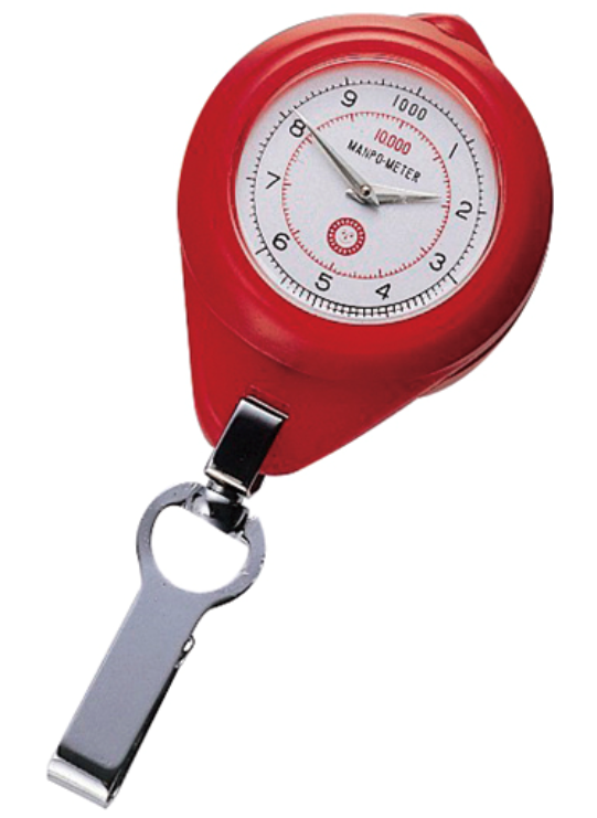
Back in 1965, a Japanese company made a device named Manpo-kei, 万歩計, which translates to “10,000 steps meter.” Its marketing campaign popularized the concept of walking 10,000 steps per day, which might burn 300 to 600 food calories.
A study concluded that taking over 4,400 steps per day correlates to significantly lower mortality rates, with the rates decreasing with more steps until leveling at about 7,500 steps.
So I used the Pedometer++ app on my iPhone and Apple Watch to get approximate counts along various walks along sections of that trail system, with a goal of walks of 7,500 steps or more for me, round-trip. Bear in mind that steps per mile correlates with height. My height is 5’8″, and on one of my walks I averaged 2,167 steps per mile.
I mapped out ten different walks here which traverse the entire scope of the Pathfinder Parkway, along with walking loops at Johnstone, Jo Allyn Lowe, and Sooner Parks.
My favorite walk is from the Washington Boulevard entrance, just north of Señor Salsa, to the Paul Hefty Bird Sanctuary at Robinwood Park and back. Happily, I found that worked out to 8,600 steps for me.
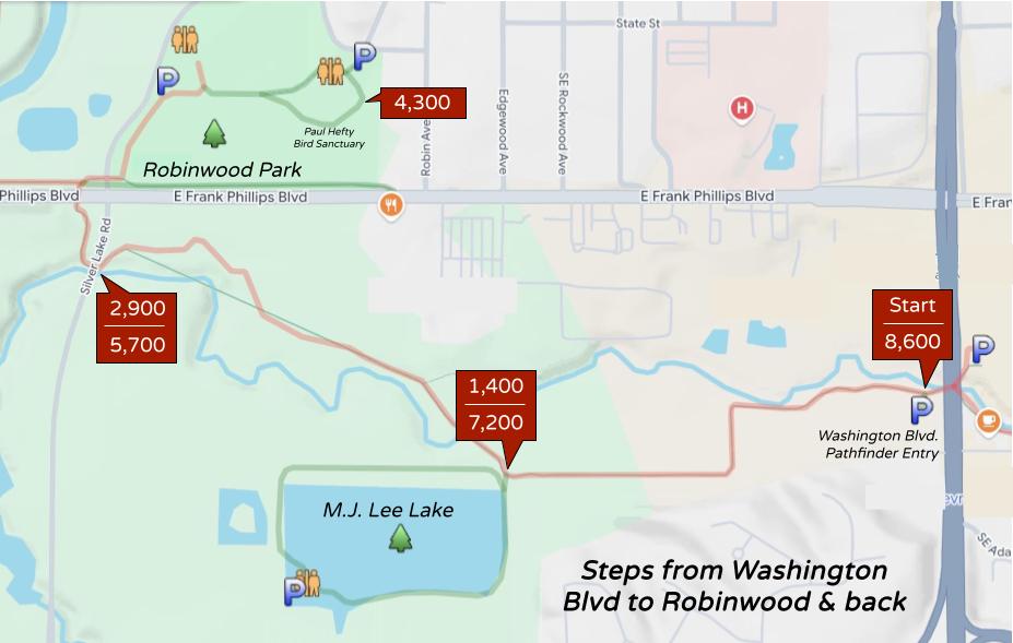
Of course, you could alternatively park at Robinwood Park, make the loop through the bird sanctuary, and then walk to Washington Boulevard and back.
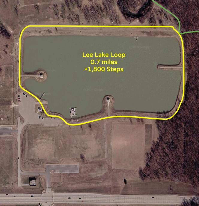
Some folks just walk the nearly shadeless 0.7 mile loop around Lee Lake, which has an embedded marker every 1/10 of a mile. That loop was roughly 1,800 steps for me, so four loops would get me pretty close to the health benefits plateau.
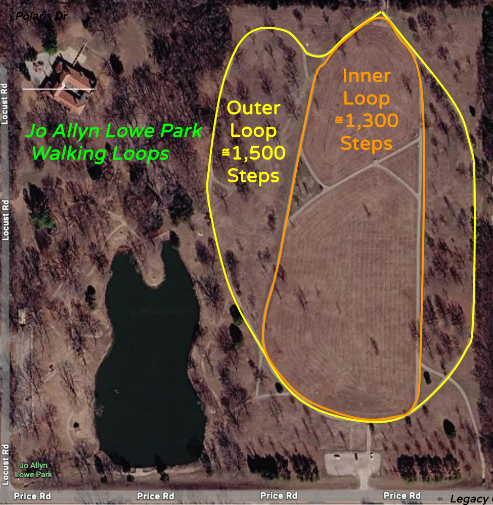
This walk starts at Polaris, just south of the Oklahoma Wesleyan University baseball field, and goes uphill past the Methodist church to Jo Allyn Lowe Park. I can make that an 8,000 step round trip if I go on to Legacy Court before turning around. It was 1,900 steps from Polaris to Stonewall Drive, 700 more to the north end of Allyn Lowe Park, another 700 to the south end at the tunnel under Price Road, and following the Pathfinder Parkway onward to Legacy Court added 700 more.
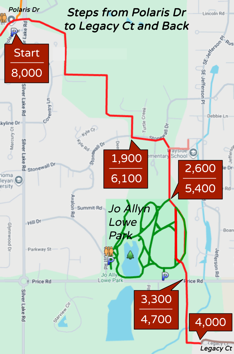
For reference, the outer loop on the eastern hillside was about 1,500 steps while the inner one was about 1,300 steps. Another way to reach the health benefits plateau of over 7,500 steps would be to start at the south parking lot at Jo Allyn Lowe, walk to Polaris and back to the park to reach about 5,900 steps, then go around the outer loop once and then walk back south across the park to the parking lot.
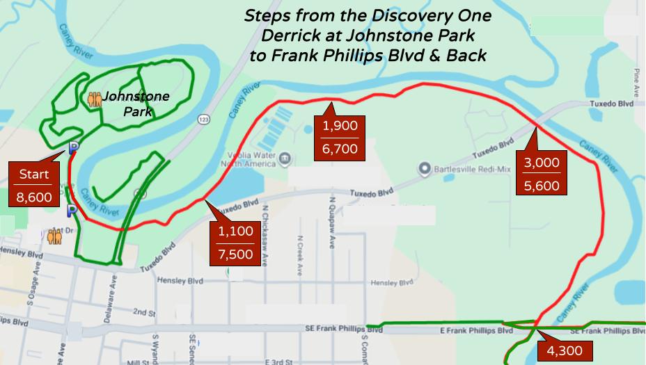
This walk begins at the Discovery One Derrick in Johnstone Park and follows the Pathfinder Parkway to Frank Phillips Boulevard. One downside to this walk are the 800 steps to go from one edge of the Chickasaw Wastewater Treatment Plant to the other, which is almost always a bit smelly.
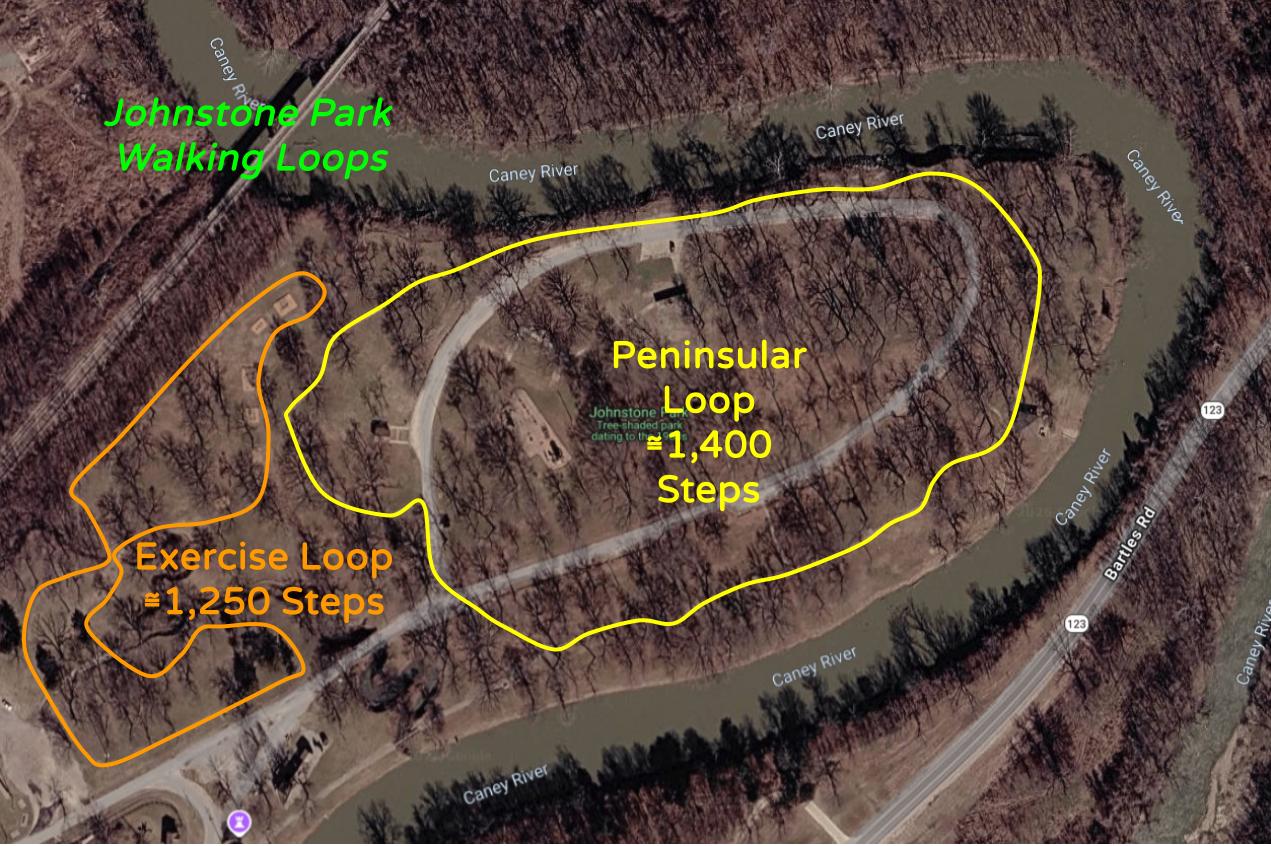
There are two walking loops in Johnstone Park. The original one around the peninsula was donated by the Service League in 1974 and built by M.R. Reed. It is said to be about 3,500 feet, and I found it to be a 1,400 step loop. The other figure 8 loop goes by outdoor exercise equipment and is about 1,250 steps. So you could do each loop three times to reach the health benefits plateau.
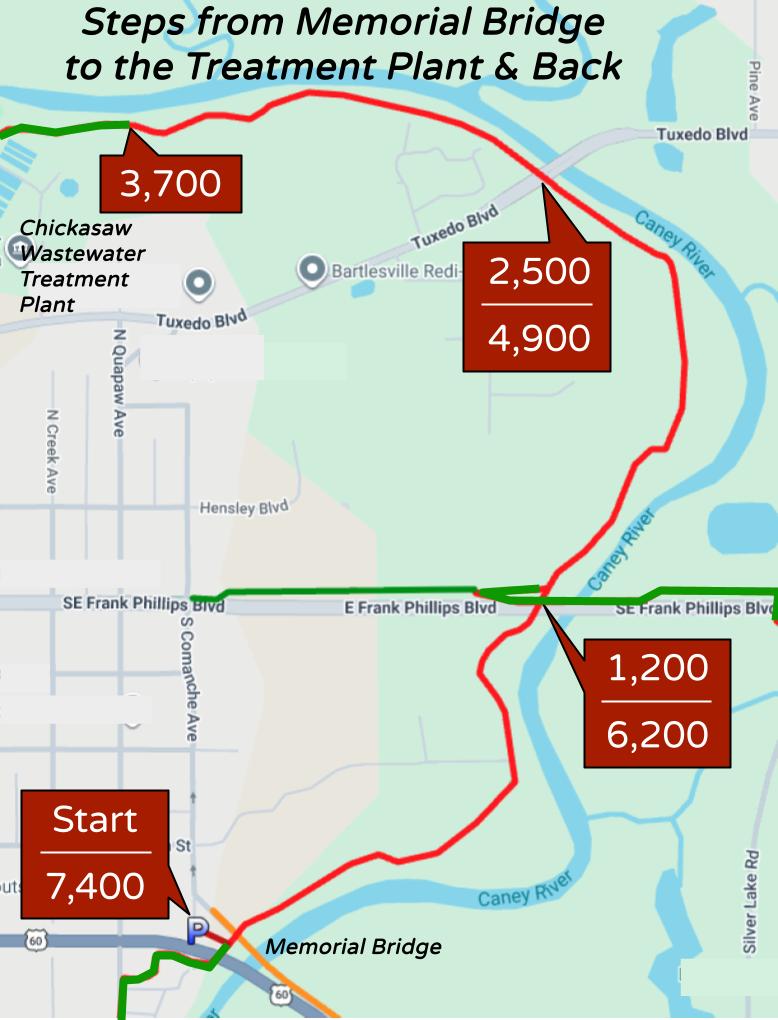
This walk starts at Memorial Bridge at the south end of Comanche Avenue and heads north past Frank Phillips Boulevard and Tuxedo Boulevard to the eastern edge of the Chickasaw Wastewater Treatment Plant. I would turn around there, before you encounter the smells.
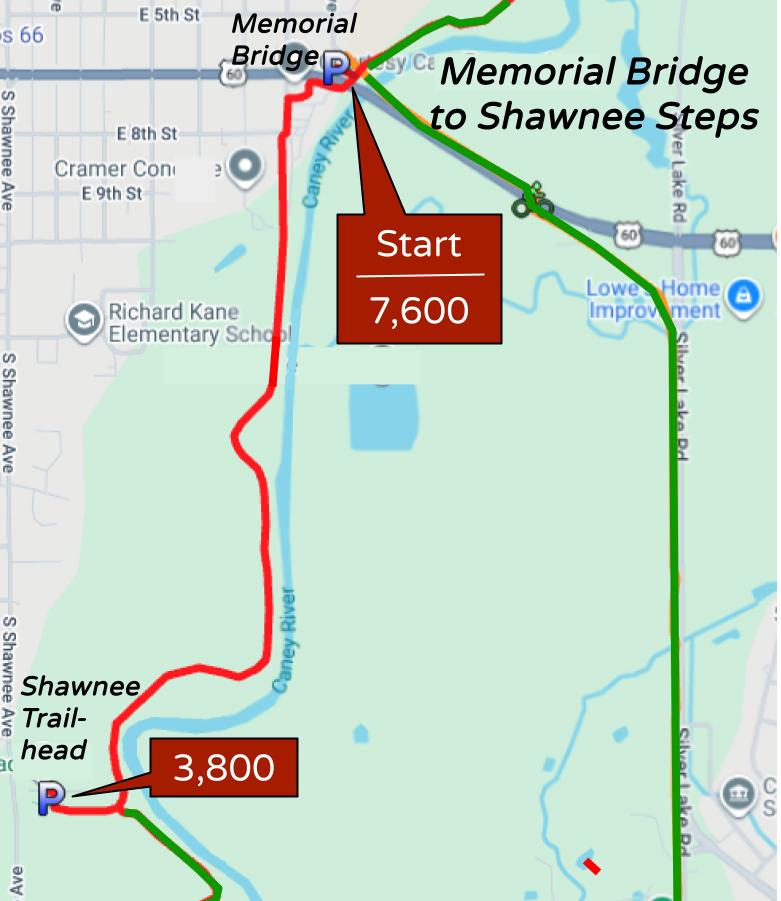
The walk between Memorial Bridge and the Shawnee Trailhead is about 3,800 steps, so a round trip hits the health benefits plateau.
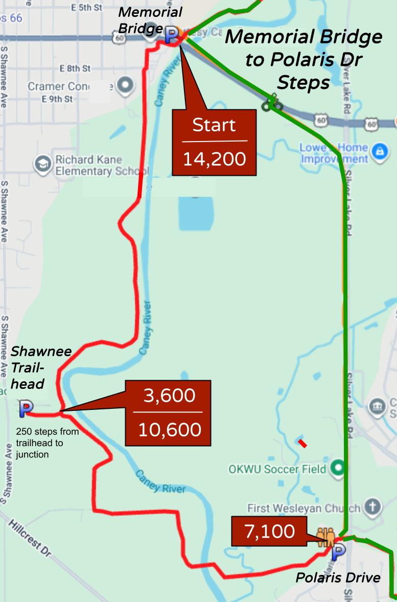
This ambitious walk goes between Memorial Bridge and Polaris via the Pathfinder Parkway, not the bike trail. That is 7,100 steps one way, which is already approaching the health benefits plateau. So the round trip is really getting up there.
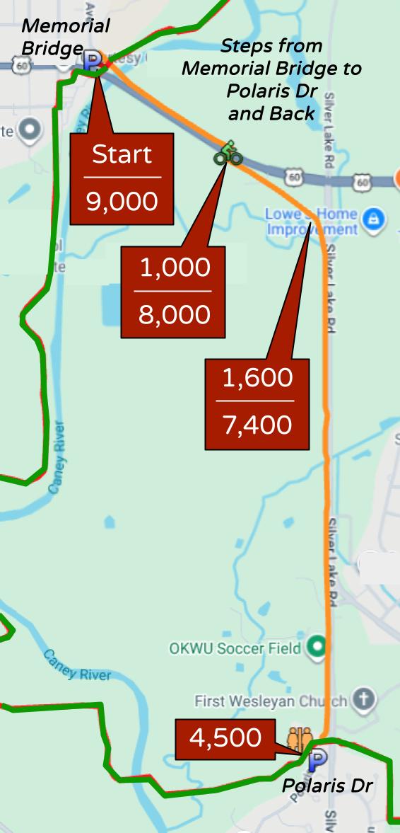
This walk is sunny and noisy, since it just uses the bike trail alongside Adams Boulevard and Silver Lake Road between Memorial Bridge and Polaris. But in the winter it might have some charm in terms of radiant energy.
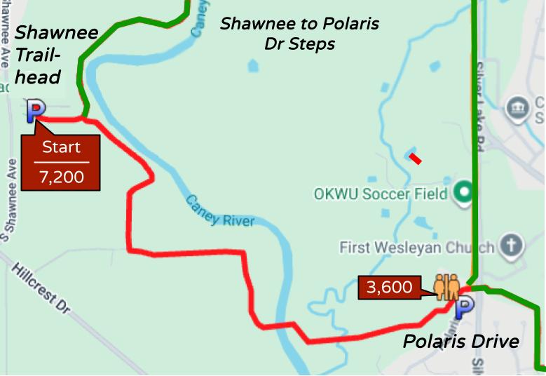
The walk between the Shawnee and Polaris trailheads is about 3,600 steps, so a round trip is decently close to the health benefits plateau. This is arguably the most attractive part of the Pathway and includes the pedestrian bridge over the Caney River, so it is one of the most frequently travelled sections.
This is a big loop, so you never backtrack. It uses the sunny bicycle trail that runs atop Memorial Bridge and then along the north side of Adams Boulevard and then ducks under the road using a tunnel and turns to track below the west side of Silver Lake Road to Polaris Drive. I like to divert west there to use the OKWU baseball field port-a-pot. Then it climbs up to the Pathfinder Parkway and follows it back to Memorial Bridge.
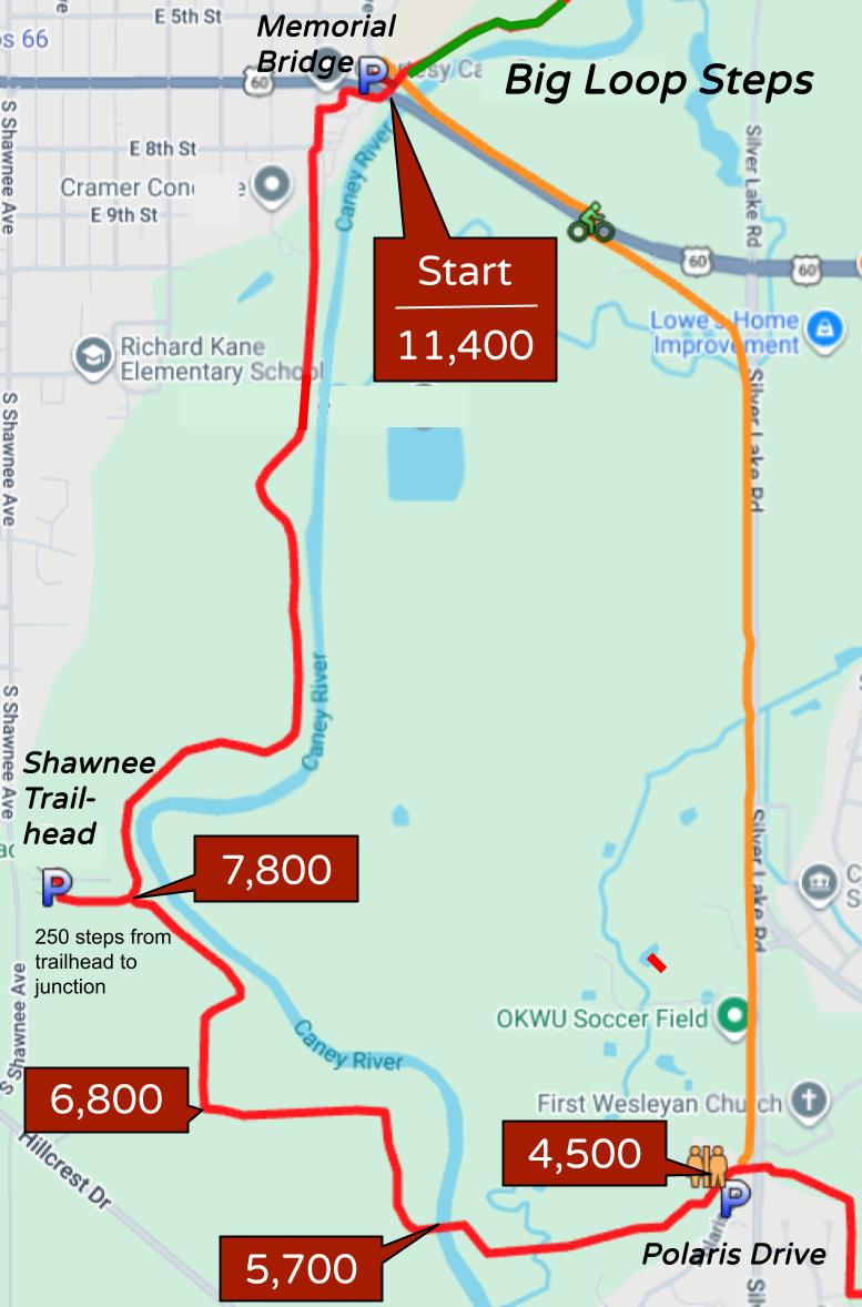
You could of course choose any trailhead to start from, but I generally like to park at Memorial Bridge and head south on the bike trail early in the day, before it gets too hot, and that also gets the busiest and noisiest section of the loop done first so the walk gets prettier as you go.
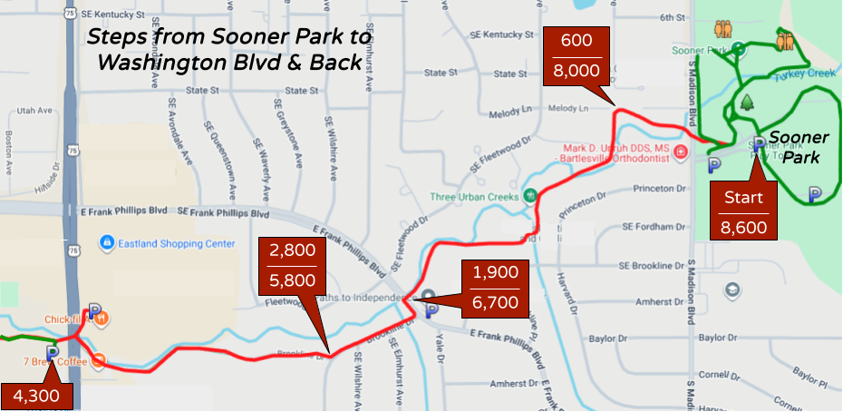
This walk between Sooner Park’s play tower and the Washington Blvd trailhead just north of Señor Salsa is 8,600 steps round-trip.
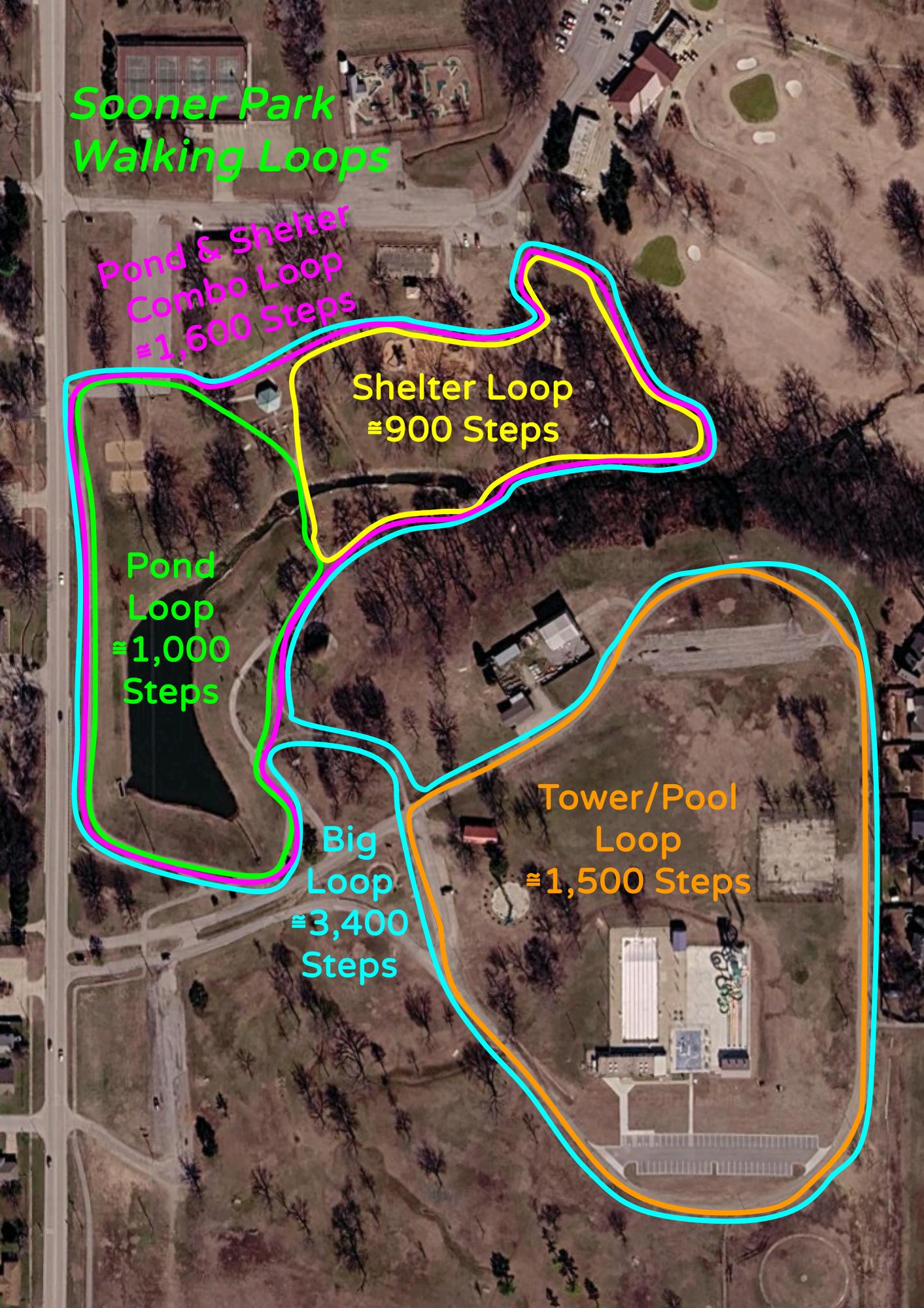
I paced out five different walking loop options at Sooner Park. You can do the big loop twice for 6,800 steps to go quite a ways toward the 7,500-step health benefits plateau.
Pathfinder Parkway Histories
2021 reconstruction of Hillcrest Drive
In 2021 the city rebuilt Hillcrest Drive between 20th Street south to the Caney River with a new wider roadway just south. The city borrow pit near the gravel road was used for that project as well as the public schools’ Agricultural Center along Shawnee Avenue.
About eight feet of the northeast side of the original pavement was preserved to link up with the protected walkway on the Caney River bridge, forming a separate pathway for bicycles and pedestrians from the Hillcrest Heights entrance south of the Caney River bridge northwest to Shawnee Avenue.
Note that while one could form a walking loop out of that by using a social trail leading southeast from the west end of the Caney River pedestrian bridge, that trail eventually turns southwest and has to cross private property to access the old Hillcrest Drive.

2020 Brookline Drive project
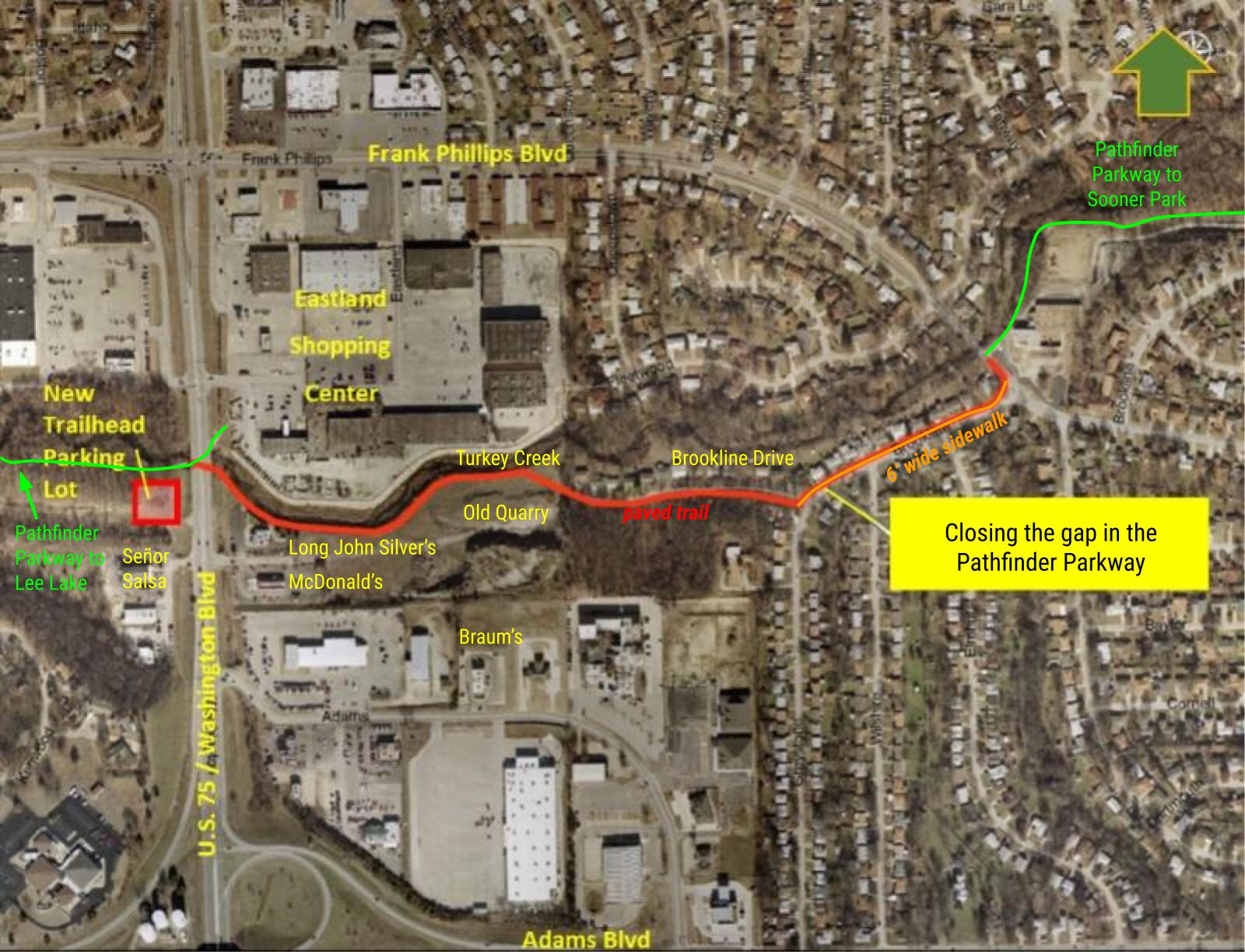
After many years, the city completed the connection from Robinwood to Sooner Park, addressing a half-mile section of Turkey Creek which had no trail from Eastland Center at Highway 75 over to the former Will Rogers School on Frank Phillips Boulevard.
The Eastland Center trailhead was replaced with a new parking area and trailhead on the west side of US 75, just north of Señor Salsa. The trail still dives under the highway but now rises on the south side of Turkey Creek to run past the drive-through of Long John Silver’s (later 7 Brew Drive-Thru Coffee), crossing through the old quarry area to the dead-end of Brookline Drive. It runs along the south side of Brookline for awhile, then crosses to become a six-foot wide sidewalk on the northwest side of Brookline Drive up to the Paths to Independence school (formerly Will Rogers) on Frank Phillips Boulevard, where the Pathfinder Parkway has long led onward past the west and north side of the school campus to Sooner Park. Click here for project photos.
2013 Bridge Together project
The boards on the large pedestrian bridge over the Caney River were rotting away and needed to be replaced. Bob Pomeroy spearheaded raising funds for the effort. Donors like Granger helped buy new planks, which were installed by October 2013.

1976 Horizons Project brochure
The Pathfinder Parkway was an Horizon’s ’76 Project sponsored by the Bartlesville Community Bicentennial Committee. They published a brochure on it. It originally was going to link Brookline Park between Robinwood and Sooner, but the Brookline connection wasn’t built until 2020, by which the time that small neighborhood park had been closed and sold off. There was also a plan for an extension southwest of Hillcrest Drive along the Caney River to Kane family property east of Circle Mountain that never materialized. The original concept also called for pathways on both the west and east banks of the Caney River from Adams to the high school, but the eastern path and additional footbridges were never constructed.

1976 Historical Tour
Recreation of the 1976 Pathfinder Parkway Historical Tour: Google Doc | PDF


Pingback: Bartlesville Byways « MEADOR.ORG ~ The virtual world of Granger Meador
Pingback: A Vector to Windows 7 « MEADOR.ORG ~ The virtual world of Granger Meador
Thank you for your pix of Mt. Nebo. My son has played football at Arkansas Tech for 2 years now and I have attempted to plead, beg and bribe him to hike the trails with me. This Saturday is his Spring game and with your pix I hope I can convince him to join me. As you said some the spots made you pause before you attempted them. I don’t think I should attempt the trail alone, so I hope he will be more receptive to my urges this time.
The spring has been very rainy and the waterfalls should still be productive. He has, yet another, a new girlfriend and I will also appeal to him.
The spring game is at 10:00 am. the morning low is expected to be 44 with a high of 76, so the weather should be perfect. If I don’t get him this time, I’ll just brave the elements alone – making sure the park rangers know I am out there alone.
Wish me luck./
Thanks for making this. I’ll be in town in a few weeks, Currently training for the Burlington Vermont marathon and need to steering together a 20 miler
Cheers
Patrick
Pingback: Passing the 300 Mile Mark for 2010 « MEADOR.ORG
Great post. The extensions to the Pathfinder could be done. I would be willing to join a group that wants to try and make it happen.
http://www.cityofbartlesville.org/meeting-set-input-pathfinder-grant/
I also would be interested in working on a committee aimed at extending Pathfinder around the city.
http://www.cityofbartlesville.org/meeting-set-input-pathfinder-grant/
I’d like for the next city bond to fund a start on Price Park, extending Pathfinder over to it, and closing the gap between Atwoods and the Will Rogers Complex. We shall see.
I have just started walking Pathfinder the past few months and my only complaint is the gap from Will Roger School to the Trail Head at Atwoods, all the traffic drives my dog Duke crazy. I would also like to see the city inprove on that area of the trail, and would be willing to support anything we can do to try to get the city to act on this.
http://www.cityofbartlesville.org/meeting-set-input-pathfinder-grant/
Mr Maedor,
Hopefully you can help me out. Back in the 50’s/60’s, was there a large asphalt race track located between Tuxido Ave and Frank Phillips Ave, just about where the orchird is located? I have asked many people about this about this and have always got a no, but I could sworn that my Dad took me by there one time when I was a kid and showed me it. I beleave he said it was not used very often.
Thanks …..
Bob, you prompted me to do a full scale internet search into your racetrack mystery, and I’ve posted a blog entry about what I found.
https://meador.wordpress.com/2012/03/12/the-forgotten-racetrack/
To explore this possibility further, you should contact Automasters on Tuxedo (1420 Tuxedo Blvd, 918-336-8594) since their business is directly south of where I think the old track was located. They may very well know something about it.
We have confirmation that there was a Micro Midget racetrack at the north end of Quapaw. See the end of the post at https://meador.wordpress.com/2012/03/12/the-forgotten-racetrack/ for the details.
Pingback: The Forgotten Racetrack? « MEADOR.ORG
Great work with the map. I’m visiting for a couple months and this was super helpful plotting a course for running. Thanks.
FYI: there is a slight variation between your original map and the one created for Google at the lead up to the suspension bridge.
Thanks for letting me know of the discrepancy – I’ve tweaked the online map to be more accurate.
Pingback: Tunnels | MEADOR.ORG
Pingback: Everyday Workouts | MEADOR.ORG