Day 1, July Escape 2013: Canyon, Texas

Trip Date: July 10, 2013

This year Wendy Kemp joined me for my traditional vacation from the hot and sweltering Oklahoma summer. We’ve taken “trips” together before, but she said this was our first “vacation” since we vacated the state for cooler climes for an extended period. We spent nine days out west in the Texas panhandle, northern New Mexico, southwestern Colorado, and across southern Kansas. The weather cooperated, with us often enjoying rain and temperatures which were sometimes 30 degrees or more cooler than back home.

DAY 1: OKC & PALO DURO CANYON

Day 1 Map (click map for slideshow)

I planned the vacation to focus on some of my familiar haunts in southwestern Colorado, but I knew better than to ask my companion to endure a 10-hour drive, plus pit stops, to reach Santa Fe in one day. Plus, I’d been advised by Facebook friends to visit Palo Duro Canyon, located just south of Amarillo, Texas in the middle of the fairly desolate Texas panhandle.

Tech Support in OKC and the Death of Latitude

So we first drove down to Tulsa and took the Turner Turnpike to Oklahoma City to drop in for lunch with my parents. My visits usually include some parental tech support, and this time I had to set up their secure WiFi network again after a power glitch wiped out the router settings.  I also spent an inordinate amount of time trying to get their Google Latitude account working again, since they use it to track my movements during my trips.  It never seemed to sync right, so we abandoned that effort for a nice lunch at El Chico, and then Wendy and I headed west on I-40 towards Amarillo, Texas.

That evening my mother reported her Latitude service was syncing again so she could track us easily, but Google announced it was killing the free service in a month. I must hope that someone will develop a suitable replacement at a reasonable price; I am not at all pleased with how Google deploys a free service, destroying the competitive market, and then abandons loyal and frequent users of that service.  It makes me distrust other Google services I rely upon, such as Google Sites and Google Drive. I hope I can find a better alternative than Google’s suggestion of using location tracking via Google+; Facebook and my blog are enough social services for me, so I have refused to develop my Google+ account beyond the bare essentials. I will see what develops in the next few weeks.

All that is left is dirt and tears…and arroyos

The Texas Panhandle

The drive to Amarillo was long and hot, with the temperature spiking above 100 degrees Fahrenheit.  We made a pit stop in poor little McLean, Texas. The town is dying out, with a single filthy convenience store and a symbolic lean dog roaming the streets. As we drove out of town, I commented to Wendy, “All that is left is dirt and tears.”

She liked that turn of phrase, but was far less appreciative of my frequent references to the arroyos as we drove westward. As “arroyo” rolled off my tongue for the umpteenth time, she spat, “Don’t you dare say that again! Don’t you dare!”

Wendy noticed and shot a photo of stacked clouds as we drove south from Amarillo towards Canyon, Texas. We checked into the Best Western at Canyon, from which it was a short drive east to Palo Duro Canyon. There we had a “chuck wagon supper” and enjoyed the “Texas!” musical at the canyon’s Pioneer Amphitheatre. (Doesn’t it seem strange that a Texas park would spell it amphitheatre?)
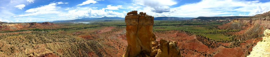
Palo Duro Canyon

Texas!

The canyon was impressive, more so than the $14 dinner of brisket, beans, and cobbler; I’d have appreciated an actual bun for my barbecue sandwich rather than plain white bread, for one thing. But the scenery was nice, and a bust of Quanah Parker set the stage for his awkward inclusion in the musical to come.

Wendy and I enjoyed looking over a large stone relief map of the surrounding area and then took our assigned seats for the musical, down near the front of the amphitheatre. “Texas!” was in its 48th season, a musical staged over the years with help from students and faculty at West Texas State College (now West Texas A&M) and updated in 2001 to be more historically accurate. The story is simple, with some awkward dialog and a few oddball numbers, but the musical hangs together fairly well.

Spectacles included folks on horseback in the background behind the stage and up on the canyon wall and a tree dramatically split by lightning. The musical was followed, however, by a blend of Branson-style jingoism with Vegas-style effects. There was a close-up fireworks show, blasts of flame which made us flinch from the warmth, dancing waters, and more. None of it blended with the musical and, while it was spectacular, if I wanted to see something from Branson or Vegas, then I would travel there.

I can’t offer up any photos of the show, since photographs were firmly banned. But I did shoot some video of some of the musical actors entertaining the crowd in the courtyard before the show:

After the show, we returned to our hotel to rest up, since the next morning we would be returning to enjoy the scenery of Palo Duro Canyon before heading northwest to Santa Fe, New Mexico.

Click here for a slideshow from this day

Day 2 of July Escape 2013 >

Posted in photos, technology, travel, video | 2 Comments

Woman by Rhye

July 7, 2013
Woman by Rhye

Woman by Rhye

A happy custom for me is to download twice each year the podcasts of favorite album and song picks by Bob Boilen and friends of NPR’s All Songs Considered. Each summer and winter break, when my mind is relaxed and prepared, I explore a collection of new songs selected by the NPR professionals.

Music is a very personal thing, so I’m motivated to purchase only a tiny fraction of their selections for my music collection. I’ve little use for their more twee and urban picks, but they always highlight something which excites my ear and quickens my pulse. Today I listened to their recent selections for The Year in Music (So Far), 2013 and one song stood out for me.

It opened with lush strings and shifted to a rhythmic click track, beating in time with an arresting voice. Was that a woman’s contralto? Or a man’s falsetto? Well, it was the aptly named Open from the album Woman by Rhye. After sampling a few tracks, I was thrilled to purchase the whole album from Amazon for only $5.

The voice belongs to Michael Milosh, a Canadian electronic musician and classically trained cellist, who moved to Los Angeles and fell in love. There he teamed up with Danish producer Robin Hannibal, who had also relocated and found love in the Golden State, and they formed Rhye.

I love sophisticated pop, and Rhye reminds me of the deep swaying rhythms and romance of Sade Adu. I commend to you Ian Horrocks’ review of the album if Open invites you in.

“Open”

I’m a fool for that shake in your thighs
I’m a fool for that sound in your sighs
I’m a fool for your belly
I’m a fool for your love

I wanna make this play oh I know you’re fadin’
Hmmm but stay don’t close your hands
I wanna make this play oh I know you’re faded
Hmmm but stay don’t close your hands

Caught in this pool held in your eyes
Caught like a fool without a line
We’re in a natural spring
With this gentle sting between us

I wanna make this play oh I know your fadin’
Hmmm but stay don’t close your hands
I wanna make this play oh I know you’re faded
Hmmm but stay don’t close your hands

Ooh, stay open
Ooh, stay open

Stay open
Stay open

I wanna make this play oh I know your fadin’
Hmmm but stay don’t close your hands
I wanna make this play oh I know you’re faded
Hmmm but stay don’t close your hands

Stay open
Stay open
Stay open

Mm, stay open

Posted in music | Leave a comment

Hot Time at Robbers Cave

June 28-30, 2013

Robbers Cave (click image for slideshow)

Our Route

Our Route

I’ve been hiking at Robbers Cave State Park about twice per year since 2009. My latest visit was prompted by my colleague and friend Betty Henderson. Her husband, John, would be riding his mule on some of the bridle trails at the park, joined by some fellow mule riders from Caney, KS. Betty wanted to hike some of the trails, while John prefers riding. So she invited Wendy and me to ride down to the park in her car for a couple of days of hot-weather hikes, with the three of us staying in McAlester. John and his riding friends arrived earlier in the week, staying at the equestrian camp in the park with their animals so they could start riding in the cool of early morning.

I avoid hiking in July or August, unless I’m at higher altitudes in Colorado or in the cool Pacific Northwest, because my enjoyment falls when the temperature rises above 90 degrees Fahrenheit. This trip would be at the very end of June, and we wound up hiking in 90s temperatures one day and 80s the next. On our hikes we kept our pace slow, drank plenty of water, and the ladies paid particular attention to the rocks and plant life along the trails, while I quested for vistas.

Heading Down to Little Dixie

Betty, Wendy, and I drove down on Friday afternoon to enjoy an Italian dinner at Roseanna’s in Krebs. Then we drove east to the park and visited John and his fellow riders in the equestrian camp before returning to McAlester to rest overnight.

Robbers Cave

Big Rocks

The next morning we arrived at the park around 9 a.m. and drove to the cave area at the north end of the park. We posed before heading out, walking through the narrow crevice between the rocks and making our way up to the top of the rock formation, pausing along the way to admire the trees amidst the immense slabs of rock. At one point Wendy climbed up into a crevice for a shot of Betty and me examining the rock walls below.

The girls triumphantly posed when we had reached the top, and then we clambered down to reach the vista of the San Bois Mountains from the huge tilted ledges below the summit. The large roots of a pine tree atop the ledge were oozing resin.

We made our way down to the cave itself and then returned to the trailhead, where I shot a large panorama with Wendy and Betty surrounded by the massive rock formation. We’d only walked about one-half mile, but the heat and elevation changes made it feel like more.

It’s quite a view

Lake Wayne Wallace

Stinky Passion Fruit

We drove away from the sheltering trees at the Robbers Cave trailhead to our next target: a walk to the cliff above Lake Wayne Wallace. We strode through a sunny field to the Lake Wayne Wallace Dam, and I led us across the high dam towards the cliff.  I was eager to ascend for another vista while Wendy and Betty enjoyed the wildflowers, such as Passion Fruit blooms and the eponymous fruit itself, which Wendy sliced open for examination. She said, “Ooo! That really stinks!”

We climbed to the top of the cliffs, where we enjoyed the panoramic view of the lake and dam and saw horse riders fording the outlet stream far below.

The view from the cliff above Lake Wayne Wallace

Tractor Show

1911 Buick

We had a late lunch at the Robbers Cave 2nd Annual Antique Tractor and Implement Show. I consumed a huge corn dog and part of a brick of curly fries before gazing at the farm machinery. A pink Farmall tractor caught my eye, along with a tiny Pennsylvania and Floyd Allen’s 1911 Buick from Wilburton.

Wrapping Up the Day

Our next stop was a tour of the Nature Center by Lake Carlton, where Wendy snapped a photo of a lounging stuffed cat. We followed that up with live black vultures, spied from the Belle Star Lodge overlook. It had been a long, hot day and we were glad to head back to McAlester for showers and a rest break. We wrapped up the evening with games at the Great Balls of Fire Family Entertainment Center.

Mountain Trail

Mountain Trail

On Sunday we were back out at the state park in the late morning, crossing Deep Ford to take the Mountain Trail a bit less than a mile up and over to Lake Carlton. It was considerably cooler than the previous day, making the average 10% grade bearable, but we were glad to rest at the lake shore while other tourists paddled about the lake. It was a slow trek back to Deep Ford.

We cooled off by donning our swim suits and floating in life vests and on Funnoodles in the swimming area at Lake Carlton before packing up and heading back to Wilburton for dinner and then driving home. We’d had a good time enjoying the great outdoors, but with summer heat upon us I don’t expect to do much hiking for awhile except for a trip to New Mexico and Colorado in mid-July.

Click here for a slideshow from this trip

Posted in day hike, photos, travel | Leave a comment

Take Me to the River

June 25, 2013

The Caney River (click image for slideshow)

This morning I awoke early to clean up my bicycle, lubricate its chain, and pump up its tires. Then I folded down the back seats in my car to expose the hole between the back seat and the trunk, quick-released the bike’s front wheel, and shoved the bike into the trunk with its rear tire sticking into the passenger compartment. I threw in the front wheel, my bike-mounted water bottle, and my helmet. I was ready for my first bike ride in many months.

Mosquitoes and summer heat were the motivators. My recent sunrise walks on the Pathfinder Parkway were rather warm, even in shorts and a light wicking Under Armour shirt, and any pause was punctuated, or should I say punctured, by mosquito bites. My bike would let me generate my own breeze and keep the mosquitoes at bay.

My Schwinn

My Schwinn

I drove over to Memorial Bridge and parked, pulling out my 21-speed Schwinn Suburban Comfort bike. Its fat Kenda Komfort tires, shock-absorbing fork, comfort riser handlebars, soft saddle, and top tube geometry combine to give me a quite comfortable ride. I put on the front tire, inserted the water bottle, and strapped on my helmet. I thumbed my bike bell to ensure my merry warning was working; it would elicit a laughing grin at least once this morning from a passed Pathfinder Parkway pedestrian.

I biked north and west to Johnstone Park, where the sight of the Caney pouring over the dam lured me to venture out on the narrow pedestrian walkway to cross the Cherokee Avenue Bridge. The concrete bridge deck, suspended from the steel truss, undulated beneath me as heavy trucks roared by and I gazed down at the Caney River as it poured over the dam, flowed across the limestone ledge, and onward toward the rising sun.

I crossed the bridge onto the peninsula formed by the horseshoe bend in the river, the bend across which Nelson Carr built his mill race for what would become Jacob Bartles‘ mill and general store. The city used to operate a tiny RV park here, but it was closed a few years ago. I pedaled down to the riverside, where pathways lead down to the water for fishing.

The low dam on the Caney River beneath the Cherokee Avenue Bridge

I enjoyed the view of the river and dam beneath the rumbling bridge. Then I made my way along the deeply worn gravel road west of Highway 123 and recrossed the old bridge on its west walkway. I retraced my path east and south to Memorial Bridge, admiring the wildflowers growing on the Gabels’ acreage south of the Pathfinder Parkway.

I then made the big loop from Memorial Bridge south along the bike path adjacent to Silver Lake Road to First Wesleyan Church and then west and north along the Pathfinder Parkway back to Memorial Bridge. Having biked over nine miles, I stowed my bike in the trunk and headed home, where pleasant pedaling would permutate into premeditated plodding behind the lawnmower. Summer’s here and thank goodness for the Pathfinder Parkway!

Click here for a slideshow from this ride

Posted in photos | Leave a comment

Bury Me Not On the Lone Prairie

June 19, 2013

The empty Osage (click image for slideshow)

Store’s gone, post office gone, train gone, school gone, oil gone, boys and girls gone — only thing not gone is graveyard and it git bigger.

Foraker resident

I live on the southeastern edge of the vast prairies of the United States, only 30 miles south of the site of Laura Ingalls Wilder’s Little House on the Prairie. Yet I must confess that I’m more fond of forests and birds than tallgrass and buffalo, so it took me decades to make it out to the Nature Conservancy’s Tallgrass Prairie Preserve, even though it is only a little more than an hour’s drive to the west in Osage County.

The Preserve is the largest protected area of tallgrass prairie on Earth, spanning 39,000 acres. It is part of what was once the Chapman-Barnard Ranch, a 100,000 acre spread once managed by Ben Johnson, Sr., the father of movie star Ben Johnson, Jr.  I’m fortunate to know the generous Ken Adams and his family, who donated 300 bison to the Preserve in 1993.  That herd has grown to over 2,500 buffalo which freely roam across 21,000 acres of the Flint Hills.  Those hills of thin soil and flinty limestone are unsuitable for plowing, which preserved some of the tallgrass prairie.

Lydie Marland

I finally visited the Preserve on a whim, having driven Wendy westward to Ponca City to tour the Marland Mansion and Marland’s Grand Home, with a lunch break at Enrique’s. I’ve already taken plenty of pictures of the Marland Grand Home, but I have almost none of the Mansion. However, on this day I did capture the setting on the grounds of a replica of Lydie Marland’s statue.

I became restless on the boring drive back home along US 60, opting to turn north to Shidler to see if the Bivin Garden was open. It turned out it is only open on weekends without an appointment and I didn’t want to backtrack to US 60, so I headed north and east along gravel roads to cut across what some pilots call “the black hole”: a large part of northern Osage County now lacking towns or highways, although it once bustled with oil boomtowns,such as Whizbang and Foraker, which Don Taylor nicely remembers in his online video:

Foraker was an agricultural boomtown of 415 by 1915 and probably reached about 2,000 in the oil boom of the early 1920s, but it has declined to less than 20 residents today. Little remains but a lonely cemetery to the east (here’s a photo by Wade Harris), which made me think of the old cowboy song requesting relocation, the bleakness amplified by the isolated roadside remains of what was once a mighty tree.

Wendy and I drove into the preserve and visited the headquarters, where a kindly docent gave us the low-down on the operation and a tour of the former bunkhouse. He told us to take the nearby Bison Loop road to find the herd, and sure enough, a great many buffalo were to be found grazing amidst the oil wells out there. The proximity of the equipment prevented me from shooting more bison.

We stopped at one of the scenic pull-outs to gaze across the prairie. It has its own kind of beauty, but bury me not on the lone prairie.

The Tallgrass Prairie

Click here for a slideshow from this day

Posted in photos, travel | Leave a comment