
Hemmed-In Hollow Falls (click image for slideshow)
I awoke early for my hot breakfast at the Hampton Inn and hit the highway, bound for Lost Valley. But I could never find it, even with Trixie the GPS leading me right to it, because the entry was blocked by “emergency closure” notices. I later discovered that a flood had wiped out a bridge, scoured much of the trail, and the site would require $250,000 for full renovation and may be converted from a campground to day use due to the flood risk…shades of what happened to the beautiful but deadly Winding Stairs area.
So I backtracked, driving past Ponca with the morning sun shining through the trees and a beautiful view of the fog amidst the mountains, to Compton for the Hemmed-In Hollow hike. It would extend to 10.2 miles, although my stupid EveryTrail iPhone app did not save the track properly, so I had to piece one together – I think I’ll go back to using MotionX.
The sandy trail led off through the trees and began a long descent towards the Buffalo River, past spiderwort and other flowers. Stone steps eased the way here and there and butterflies flitted and landed hither and thither.
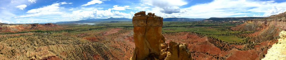
I reached a campsite and found a promised overlook which provided a panoramic view of the hollow and across the way I could see where a tiny creek had carved its way through the stone, ending in a fall of 209 feet, the highest waterfall between the Appalachians and the Rockies.
The trail continued downward, finally reaching Sneeds Creek, which I paralleled until I found a stone ford someone had thoughtfully arranged. The creek ran into the Buffalo River, and a large tree had fallen victim to its relentless erosion. I followed the Old River Trail past the foundations of the Centerpoint School, which reportedly was so named because of its location at the center of its district.
The remains I saw were from a building built in 1920 but burned in 1937 after a pupil, who had paraded naked in front of his classmates, burned down the building after the consequent whipping. The ornery fellow, or his brother, then again burned the rebuilt structure before it opened. A lady of the day described them both as “mean as snakes” and at least one went off to a reform school. I suppose the school was rebuilt yet again, but it finally closed in 1951 and floated away in a flood a decade later. Today there is only an overgrown set of foundation stones.
In low water one can easily ford the Buffalo at the horseshoe bend here to continue along the trail, but the water was up enough for my float trip a day earlier a bit downstream and the only way I’d get across would be to doff my footwear and struggle across the stony river, something I had no interest in doing. So I admired the reflections in the water, discovered a family camping out on the river shore nearby, and then retraced my steps so I could take the other part of a loop trail to the falls.
I reached a scenic side creek and took a self-portrait. At a later prettier side creek, a backpacking couple came up the trail behind me to ask if they were on the right track. I assured them they were – I’d yet to see the falls, but my trail map showed we were fine, although there is a confusing lack of signage at several trail junctions. I sat down to cool off and snap another self-portrait, since it had risen from the 70s into the 90s and I did not want to dog the couple as they strode to the falls.
The trail narrowed beside a small creek, I crossed a treacherous washout, and then the narrow defile suddenly opened into a wide bowl with the spectacularly high falls directly ahead. There was only a spattering of water, but it came from on high. After gaping awhile, I offered to snap the photo of the backpacking couple and then moved away to photograph the eroded walls with close-ups, how the bowl left only a patch of sky open, and to shoot a movie.
I ate a snack and guzzled down another bottle of water before heading back, past tiny waterfalls and a treefall across the creek, determined to head down this side of the loop to the Buffalo River so that only a tiny portion of trail would remain unseen because of the high water.
The trail meandered through the trees and past a flat creek bed to where the creek was digging into a side bluff and shot the light patterns reflecting up onto the rock. I reached the Buffalo, discovering more campers, who were out in the stream fishing.
I met a couple from eastern Europe, who asked if they were headed to the falls. No, they were downstream about a mile from the falls, and the couple were clearly perturbed by the confusing paths. So I turned them around and said I would guide them to the right path. I shot some jigsaw blocks on our way and directed them onto the right course before turning about for the infamous climb out of the hollow.
It is a steep 1300 foot climb back up to the Compton trailhead, and it was humid and in the 90s. I staggered uphill, pausing now and then when my heart pounded me to a stop. I passed colorful bugs, flowers of varying colors, but was dismayed whenever I hit a set of sunny steps. So I was thrilled when I hit the junction for the final leg. But I still found the energy to shoot some more butterflies.
A fellow came along the trail, carrying a walking stick, and we chatted. He showed me the tiny camera he’d attached to his stick, one of the new tiny HD video cameras in a waterproof housing people wear on their ski helmets and the like. He does camera work for Channel 11 out of Little Rock, and said hauling this camera down to the falls and back up and out was a far cry from the 25 pound TV camera he’d hauled in five years earlier.
I was bushed when I reached the car after almost six hours of hiking, but given my early start I knew I could squeeze in another short hike before nightfall if I took a breather. So I cleaned up and drove down to Jasper, where I ate a delicious 6-inch pizza at Pizza on the Square and then drove south to Alum Cove.
The steep and winding road led up and down the mountains, passing the high bluffs of the Little Buffalo, an old barn near Parthenon, and more. It was a truly scenic drive.
At Alum Cove there is a loop trail of a bit more than a mile there, with the primary focus being a natural bridge, 130 feet long and 20 feet wide, carved from rock bluffs and actually used as a bridge by early settlers who moved their wagons and livestock across it rather than struggle through the stream during wet weather. Oldtimers are said to recall seeing lumbermen drive loaded log trucks over the natural “roadway” atop the arch during the rainy season.
The trail soon led across the odd bridge, with rails recently repaired by volunteers with the Arkansas Master Naturalists, who arranged to have new ones sawed and transported 90 miles to the site when the forestry service failed to secure any. They also cleaned up damage from a 2009 ice storm.
The area was lush, and soon after crossing a creek I saw the first entrance to a series of interconnected bluff caves, called goat caves by the locals because of the critters that once roamed here. I found six humans, not goats, roaming the caves and took a group photo for them before posing for my own shot.
There were interesting holes and pillars, and a final entrance to a larger cave before the trail wound back around under the natural bridge, with the group I’d met at the caves providing scale for my shot. There were interesting views from under the large bridge, but I was glad to finally climb the stairs back up to the trailhead.
The drive back to Harrison along Highway 7 was also scenic, except for the decaying remains of the failed Dogpatch theme park. I showered at the hotel and then had a delicious French Dip at the nearby Neighbor’s Mill Bakery and Cafe, along with part of a peanut butter cookie. I ordered a turkey sandwich to go, which I put in the hotel room fridge along with my cookie to take on my hikes tomorrow at Sam’s Throne and Round Top Mountain.


Pingback: Junebug Day 9: Ghost Ranch « MEADOR.ORG