Hike Date: March 17, 2016 | SLIDESHOW | PHOTO MOSAIC
On Saint Patrick’s Day 2016, Wendy and I circumnavigated Lake Leatherwood near Eureka Springs, Arkansas on a 4.1 mile hike. Far less hilly than our trek a day earlier on the Dogwood Overlook Trail, this hike was a beautiful walk through the forest in one of the largest municipally owned parks in the nation.
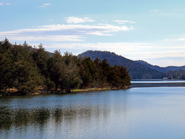
Beautiful Lake Leatherwood (click image for slideshow)
Lake Leatherwood Hike
Leatherwood Park
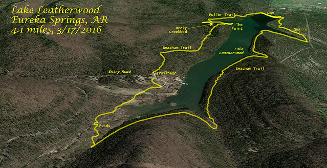
Leatherwood City Park is 1620 acres and was developed in the late 1930s under the Soil Conservation Service and Works Progress Administration with labor from the Civilian Conservation Corps. A limestone-covered dam impounds the 80 acre lake, and the old cooking pavilion, diving platform, and bathhouse remain in service. What piqued my interest was that 25 miles of hiking and biking trails have been developed around the lake area, and the city has a nice online map detailing them.
Beacham Trail and The Point
It was a 15 minute, 9 mile drive from Sugar Ridge Resort to the park, with a long and winding road to the Beacham Trail entrance. That trail circumnavigates the entire lake, but I was disappointed to find the trail on the east side of the lake is a rutted and rocky road. So we took the Point Camp turnoff to escape the monotony. That led to a nice point out on the lake, where we could get a panoramic view of the dam and the surrounding forest. We saw groups of hikers making their way across the dam in the distance.

Point Camp Panorama

Wendy hunts for crystals
Leaving the point, we diverted onto the Fuller Trail, which was much more to my liking. It led across a rocky streambed, where Wendy delighted in hunting for pretty rocks and crystals while I clambered upstream. I reached the Beacham Trail and turned back. When I rejoined Wendy, who was still busily sniffing out rock treasures, she made it clear we must return to this spot in the future. I happily agreed.
The Fuller Trail led past another creekbed and approached the lake shore. A fisherman in a white shirt and his boat gleamed out on the lake. The trail then ended, and we were back on the Beacham, which was now more trail than road as it approached the dam.
Lake Leatherwood Dam

Down the face
Before we took the straight shot across the top of the dam, I peeked around the back side, pleased to find a trail leading down past its eroded limestone blocks to the spillway. The dam is actually built of concrete and covered in hand-cut limestone blocks quarried nearby, making the erosion less worrisome. The water roaring down its rocky face was quite impressive, and we enjoyed the view from below and from above. The tranquility across the lake to the south contrasted with the roaring water toppling over the edge of the dam to the north.
Crossing the dam, we soon reached the limestone quarry, which was a cut from a rock ledge. There were a number of large stones still waiting in the quarry, decades after they were cut.
Calm After the Roar
I enjoyed the quiet and isolation of the narrower stretch of the Beacham Trail on the east side of the lake, with plenty of lake views. We passed a peace symbol made of rocks, bringing to mind my childhood visits to Eureka Springs and the hippies that hung out there back in the 1970s. Today it is still a bohemian oasis in the Ozarks, welcoming alternate lifestyles.
Fording West Leatherwood Creek

Stranded bridge
The trail wound up and around three different entry creeks before reaching the floodplain of West Leatherwood Creek. The wide rocky creek bed was quite different from the forest trail we had been using. A wooden bridge stranded in the rocks tried to provide access. But the bridge we really needed had been swept away, so we got our boots and socks wet fording the creek. It was a shame the beavers had not felled some trees in a direction that would have helped us out.
We passed some cattails as our hike came to a close, with us walking past campsites and old rental cabins to return to our car. It had been a delightful hike. I look forward to returning here, both to let Wendy find more rock crystals and to hike the Miner’s Rock and Overlook trails on the hillside above the east side of the lake.
A Maelstrom at Crystal Bridges and The Open Road
Our brief stay in the Ozarks was drawing to a close. The next day we headed home, stopping over at the Crystal Bridges Museum of American Art in Bentonville, where we admired a whirling mass of painted aluminum by the walkway. Maelstrom by Alice Aycock reminds one of a tornado vortex, or flower blooms, or a shell.

Maelstrom by Alice Aycock
The temporary exhibit, which we enjoyed for free thanks to our dual memberships in Woolaroc and its membership in the North American Reciprocal Museum Association, was The Open Road, a photography exhibit on road trips. I liked the grumpy-looking woman in front of a colorful wall in an untitled piece by William Eggleston. Joel Sternfeld’s McLean, Virginia, December 1978 was a standout with its portrayal of a fireman picking out a pumpkin as a house burns in the background.
Wendy and I were grateful for our short break in the Ozarks. Our next hike would be at the end of March, on the Skull Hollow Trail at Lake Oologah.