Wildflower Lane

On Wildflower Lane (click image for slideshow)

On my day hikes on Black Friday 2010 I’d been unable to take the Rock Creek Trail near Veterans Lake in the Chickasaw National Recreation Area (which is still Platt to me). Three major projects had been underway at the time: rehabilitating the dam, a north shore trail for the lake, and removal of eastern red cedars in the area. I would see all of these improvements up close on a hot Saturday in early June, hiking over six miles on the Rock Creek Trail and another three miles around the shores of the lake.

I found the north trailhead near the lake and set off on what would prove to be a trek strewn with wildflowers, which I’ll struggle to identify. They were a clear contrast to the organized horticulture of Woodward Park on the previous day. First up were Black-eyed Susans with their distinctive conical centers. Trail 1 led south past an embankment and above Rock Creek and then rose to the rocky top of the embankment. Patches of coneflowers and phlox attracted butterflies, a tree made the sign of four, and there was thelesperma and a trail toad.

Beebalm and and thistle attracted more butterflies and there were some more unusual offerings, including yellow flowers sticking their tongues out at me. I passed fading oxeye daisies and followed what I termed Wildflower Lane southward until I turned off to explore what may have once been Gilsonite, an asphalt mining area with trace remnants of old roads of the same material. Throughout this area were the remnants of destroyed eastern red cedars. I reversed course and returned northward, taking the eastward Trail 3 to return to the trailhead.

I passed more thistle and the trail paralleled a streambed groove in the prairie into which a big conglomerate boulder had fallen. More flowers reminding me of hungry mouths gaped at me and I passed one last stand of wildflowers as I approached the improved spillway of Veterans Lake. I finished my wildflower trek with a contrasting cactus.

I decided to next circumnavigate the lake so I could see the new north trail. The primary feature was a shelter stuck out on a projecting peninsula. The sunny walk along the wide concrete path was not inspiring, lacking the wildflowers and softer footfalls of the Rock Creek trail.

By then it was past noon and I was starving, having been too hot on the trail to stomach the typical turkey sandwich. So I cooled off in the car and drove to Sulphur’s Sonic for lunch. A quarter-pound hot dog, tater tots, cherry limeade, and chocolate shake restored my energy so I could drive south along old Highway 77 across the Arbuckle Mountains to Turner Falls.

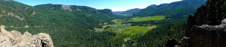
The Arbuckles are the ancient worn-down roots, or anticline, of a mountain range that is hundreds of millions of years old. I well remember visiting its tombstone topography, due to eroded strata tilted on end, during a geology field trip when I was at OU.

Today I-35 blasts through the shallow roots of the range, but back in the 1920s George Ramsey of Ardmore initiated a project to build the first highway across the Arbuckles, which was done using prison labor from the Oklahoma State Penitentiary in McAlester. The road features tilted strata as you climb hairpin curves to a panoramic overlook of Turner Falls.

Named after pioneer Mazeppa Turner, this has been a recreation spot since 1868 and is operated by the city of Davis. Back in junior high or high school my friend Jeff and I camped with his family at Turner Falls. We swam in the pools, strolled along Honey Creek, and clambered about the hillsides. For some reason one of my clearest memories is of Jeff playing Wizard of Wor there: I was hopeless at video games, but he could advance far enough to earn a bonus warrior, and I loved how the crude voice synthesizer would have the Wizard taunt, “Another warrior for my babies to devour.” The park’s odd ruins of Collings Castle, built by OU’s education dean back in the 1930s, are fun to explore and featured at Abandoned Oklahoma.

From my vantage point at the overlook I could see folks wading above the falls, Collings Castle sticking out above the trees, and I shot a jiggly video of the area. I know one of my just-graduated students is working at Turner Falls this summer, and I wished I had brought a swimsuit so I could take a refreshing splash in Honey Creek. But, like any water park, Turner Falls is best suited to group activity, so I put off a nostalgic return for a future day with friends.

Click here for a slideshow from this day hike

Posted in day hike, photos, travel, video | Leave a comment

A June Stroll Through Woodward Park

Woodward Park (click image for slideshow)

Echoing part of my winter day last January, on a hot Friday afternoon in early June I had the Chatsworth at Kilkenny’s and then roamed lovely Woodward Park in Tulsa, admiring the flowers. I’d originally planned to see a movie, but opted to stroll in the sunshine.

The most beautiful park in Tulsa, now adorning the Maple Ridge neighborhood in the northeast quadrant, began as Perryman’s Pasture and was originally criticized for being so far out of town that only wagon trails led to it. Tulsa bought the 45 acres, which was part of Helen Woodward’s allotment from the Creek nation, for $4,500 back in 1909. The rock gardens on the north end are in constant use by photographers.

The roses in their own renowned garden were slowly wilting, but the lily pads by the classic Lord & Burnham conservatory were thriving. Inside, a lad sweltered in the humidity. It was too uncomfortable in there to linger long, so I did not identify the names of the plants with odd orange petals resembling the blades of a fan, a red tongue with an inverted yellow uvula, a profusion of pink-veined petals, and a petal pool.

I retreated outside to walk through the three acre arboretum, surrounded by palatial homes, and then explored the newer Linnaeus Teaching Gardens, which are valued at over a million dollars. Impressive supertunias and pink hydrangeas in the entry garden were followed by Rosalind Cook’s portrayal of Carl himself, offering a friendly greeting. The shaded outdoor classroom offered shelter from the blazing sky. I walked through the cooling water garden, pursued by koi.

Then I strolled north across the lawns past the squirrels and Cook’s Poems and Promises to the sounds of a harp, watching a young cowboy and his friends explore the rock gardens. I crossed the bridge and passed the steps, which on this hot day contrasted sharply to their appearance in the January snow.

I made the right choice – Woodward Park beats the bijou any day.

Click here for a slideshow from this stroll

Posted in photos, travel | 1 Comment

Sam’s Throne

Sam's Throne (click image for slideshow)

I got off to a later start on Sunday morning, recovering from a late night of photo editing. So I did not arrive at Sam’s Throne, a popular Ozark National Forest location in the Boston Mountains for rock climbers, until around 10 a.m. I was surprised by the drive along Highway 123 south of Mt. Judea, which was extremely steep with sharp turns and 10 mi/h switchbacks. Clearly this was an old forest road they had not improved to highway standards, and later I verified it was a gravel road until 1997. But at least it was paved and had guard rails!

Sam’s Throne itself was only announced by a simple wooden sign at the entrance and there were none of the typical trailhead maps. I’d guess that climbing enthusiasts are responsible for marking and maintaining the trails and reportedly there are about a hundred climbing routes around the bluffs. I would spend the morning hiking around the base and then up on the rim of the bluffs north of the throne itself, a slightly lower sandstone capped mount to the southeast. They say buffalo herder and farmer Sam Davis lived in the valleys of Newton County in the 1820s and would climb up to the rock and preach fire and brimstone sermons, motivated by anger at losing a sister he believed kidnapped by Indians.

I did not drive past the gate into the camping area, so I began the hike without finding the yellow blazed trail mentioned in my guide book. I just took a random trail down the hillside from the first campsite, quickly landing on the edge of the long bluffs for my first glimpse of the throne and a panoramic view to the west. The trail soon led down through a tumble in the bluff to its base. I soon encountered two teenagers examining the bluff face, looking for a place to climb.

I marched onward along the base, passing a large pedestal and noticing that I was already perspiring heavily in the heat and humidity as I clambered along the trail, passing overhangs and a small cave formed by a split in the bluff. I passed towering projections and trees, eventually realizing that I must have missed the turn to head along the ridge to the throne itself. Why, oh why, can’t these trails have better signage? The trail became much rougher and less used, but I wasn’t in the mood to backtrack and try to locate the unremarkable trail I needed. Instead I just clambered on, challenged by the ever-rougher base trail. Once I spotted two climbers with gear prepping overhead for a descent.

A narrow vault towering several stories in the side of the bluff was a welcome cool spot where I could escape the sun’s rays and have a drink while I pondered what to do. I decided to continue on until I found an easy way to the top of the bluff. By now I knew I was on the eastern side of the bluff. I spotted a climber’s chain left in the rock face and passed more caves until I finally found a way up top.

It was cooler, more scenic, and far easier going on the upper rim trail. I could look southwest down the east valley and shot a panorama. I was ready for a break and up ahead saw a promising promontory. It afforded a view back of the bluff edge I’d been strolling along and a shaded rock where I could sit and enjoy the turkey sandwich and cookie I’d bought the day before at the Neighbor’s Mill Bakery. I clambered out against a tree for a self-portrait, and shot the tree against the background forest.

Then I strolled on around the bluff until Sam’s Throne hove into view. There was no way I was clambering back down the bluff to make it over there in the heat and humidity. Part of the bluff had a peculiar cobbled form which I figured must be fun for climbers. I could look up the west valley now with its farmland bottom and shot another panorama.

I encircled the bluff top with all available trails and then returned to my car tuckered out by the weather and earlier rough trails even though I’d gone less than three miles. My next goal was what promised to be a better-marked hike at Round Top Mountain just south of Jasper, where I’d had lunch yesterday. But when I drove down the steep grade toward Jasper I found the entrance to Round Top Mountain blocked off. Just as Lost Valley had been closed due to flood damage, so was Round Top Mountain.

That cinched it – I was calling it a day. I drove back to a not-so-scenic viewpoint and cleaned up and then drove down into Jasper and ordered the same pizza I had yesterday. It was just as delicious and gave me the energy for the long drive home, passing one particularly pretty mountainside home near Jasper. While I enjoyed the superior scenery on these latest hikes, I think I’ll avoid the humid heat of Arkansas for the remainder of my summer break, concentrating on less humid areas of Oklahoma in June and heading to New Mexico and Colorado in July.

Click here for a slideshow from this day hike

Posted in day hike, photos, travel | Leave a comment

Hemmed-In Hollow & Alum Cove

Hemmed-In Hollow Falls (click image for slideshow)

I awoke early for my hot breakfast at the Hampton Inn and hit the highway, bound for Lost Valley. But I could never find it, even with Trixie the GPS leading me right to it, because the entry was blocked by “emergency closure” notices. I later discovered that a flood had wiped out a bridge, scoured much of the trail, and the site would require $250,000 for full renovation and may be converted from a campground to day use due to the flood risk…shades of what happened to the beautiful but deadly Winding Stairs area.

So I backtracked, driving past Ponca with the morning sun shining through the trees and a beautiful view of the fog amidst the mountains, to Compton for the Hemmed-In Hollow hike. It would extend to 10.2 miles, although my stupid EveryTrail iPhone app did not save the track properly, so I had to piece one together – I think I’ll go back to using MotionX.

The sandy trail led off through the trees and began a long descent towards the Buffalo River, past spiderwort and other flowers. Stone steps eased the way here and there and butterflies flitted and landed hither and thither.

I reached a campsite and found a promised overlook which provided a panoramic view of the hollow and across the way I could see where a tiny creek had carved its way through the stone, ending in a fall of 209 feet, the highest waterfall between the Appalachians and the Rockies.

The trail continued downward, finally reaching Sneeds Creek, which I paralleled until I found a stone ford someone had thoughtfully arranged. The creek ran into the Buffalo River, and a large tree had fallen victim to its relentless erosion. I followed the Old River Trail past the foundations of the Centerpoint School, which reportedly was so named because of its location at the center of its district.

The remains I saw were from a building built in 1920 but burned in 1937 after a pupil, who had paraded naked in front of his classmates, burned down the building after the consequent whipping. The ornery fellow, or his brother, then again burned the rebuilt structure before it opened. A lady of the day described them both as “mean as snakes” and at least one went off to a reform school. I suppose the school was rebuilt yet again, but it finally closed in 1951 and floated away in a flood a decade later. Today there is only an overgrown set of foundation stones.

In low water one can easily ford the Buffalo at the horseshoe bend here to continue along the trail, but the water was up enough for my float trip a day earlier a bit downstream and the only way I’d get across would be to doff my footwear and struggle across the stony river, something I had no interest in doing. So I admired the reflections in the water, discovered a family camping out on the river shore nearby, and then retraced my steps so I could take the other part of a loop trail to the falls.

I reached a scenic side creek and took a self-portrait. At a later prettier side creek, a backpacking couple came up the trail behind me to ask if they were on the right track. I assured them they were – I’d yet to see the falls, but my trail map showed we were fine, although there is a confusing lack of signage at several trail junctions. I sat down to cool off and snap another self-portrait, since it had risen from the 70s into the 90s and I did not want to dog the couple as they strode to the falls.

The trail narrowed beside a small creek, I crossed a treacherous washout, and then the narrow defile suddenly opened into a wide bowl with the spectacularly high falls directly ahead. There was only a spattering of water, but it came from on high. After gaping awhile, I offered to snap the photo of the backpacking couple and then moved away to photograph the eroded walls with close-ups, how the bowl left only a patch of sky open, and to shoot a movie.

I ate a snack and guzzled down another bottle of water before heading back, past tiny waterfalls and a treefall across the creek, determined to head down this side of the loop to the Buffalo River so that only a tiny portion of trail would remain unseen because of the high water.

The trail meandered through the trees and past a flat creek bed to where the creek was digging into a side bluff and shot the light patterns reflecting up onto the rock. I reached the Buffalo, discovering more campers, who were out in the stream fishing.

I met a couple from eastern Europe, who asked if they were headed to the falls. No, they were downstream about a mile from the falls, and the couple were clearly perturbed by the confusing paths. So I turned them around and said I would guide them to the right path. I shot some jigsaw blocks on our way and directed them onto the right course before turning about for the infamous climb out of the hollow.

It is a steep 1300 foot climb back up to the Compton trailhead, and it was humid and in the 90s. I staggered uphill, pausing now and then when my heart pounded me to a stop. I passed colorful bugs, flowers of varying colors, but was dismayed whenever I hit a set of sunny steps. So I was thrilled when I hit the junction for the final leg. But I still found the energy to shoot some more butterflies.

A fellow came along the trail, carrying a walking stick, and we chatted. He showed me the tiny camera he’d attached to his stick, one of the new tiny HD video cameras in a waterproof housing people wear on their ski helmets and the like. He does camera work for Channel 11 out of Little Rock, and said hauling this camera down to the falls and back up and out was a far cry from the 25 pound TV camera he’d hauled in five years earlier.

I was bushed when I reached the car after almost six hours of hiking, but given my early start I knew I could squeeze in another short hike before nightfall if I took a breather. So I cleaned up and drove down to Jasper, where I ate a delicious 6-inch pizza at Pizza on the Square and then drove south to Alum Cove.

The steep and winding road led up and down the mountains, passing the high bluffs of the Little Buffalo, an old barn near Parthenon, and more. It was a truly scenic drive.

At Alum Cove there is a loop trail of a bit more than a mile there, with the primary focus being a natural bridge, 130 feet long and 20 feet wide, carved from rock bluffs and actually used as a bridge by early settlers who moved their wagons and livestock across it rather than struggle through the stream during wet weather. Oldtimers are said to recall seeing lumbermen drive loaded log trucks over the natural “roadway” atop the arch during the rainy season.

The trail soon led across the odd bridge, with rails recently repaired by volunteers with the Arkansas Master Naturalists, who arranged to have new ones sawed and transported 90 miles to the site when the forestry service failed to secure any. They also cleaned up damage from a 2009 ice storm.

The area was lush, and soon after crossing a creek I saw the first entrance to a series of interconnected bluff caves, called goat caves by the locals because of the critters that once roamed here. I found six humans, not goats, roaming the caves and took a group photo for them before posing for my own shot.

There were interesting holes and pillars, and a final entrance to a larger cave before the trail wound back around under the natural bridge, with the group I’d met at the caves providing scale for my shot. There were interesting views from under the large bridge, but I was glad to finally climb the stairs back up to the trailhead.

The drive back to Harrison along Highway 7 was also scenic, except for the decaying remains of the failed Dogpatch theme park. I showered at the hotel and then had a delicious French Dip at the nearby Neighbor’s Mill Bakery and Cafe, along with part of a peanut butter cookie. I ordered a turkey sandwich to go, which I put in the hotel room fridge along with my cookie to take on my hikes tomorrow at Sam’s Throne and Round Top Mountain.

Click here for a slideshow from this day hike

Posted in day hike, photos, travel, video | 1 Comment

Neither Tippecanoe Nor Tyler Too

9 Miles Down the Buffalo River

The U.S. Presidential election of 1840 is probably best remembered for the Whig campaign song, Tippecanoe and Tyler Too. And today I found myself downstream from Tyler Bend on the Buffalo National River, where I had hiked a year ago, having spent the night just a few miles from Buffalo Point and Rush. Little did I expect, watching folks launch their canoes at Rush last year, that I would be in a canoe floating down the Buffalo a year later.

I’d never been in a canoe before, so Tippecanoe was on my mind, not because it means “buffalo fish” in Miami-Illinois, but because I well remembered my father coming home from a float trip when I was a child and watching him empty his soggy wallet, laying out each item to dry. I did not want to tip a canoe.

Our Cabin

I was in good hands, however, with a group of friends from work who had experience with canoes. We had rented a cabin overnight near Buffalo Point. It slept 16 and there were only six of us. A couple took one bedroom and the others scattered, with me the only person bedding down in a dark basement filled with five beds – I took one in the far corner, which previous visitors to the cabin called the “lonely bed” in a memory book. No, that bed is not shown on the website. The quiet creaks above me when my companions visited the facilities in the night kept me from feeling too lonely, however. It was a great place for our stay.

This morning we secured three canoes for a 9-mile float trip from Maumee North to Dillard’s Ferry. We parked at the ferry and a school bus hauled us upstream to Maumee North where we split into pairs for the float downstream. The water level was fine and it was fun to paddle our way down the gentle river, saved in 1972 from the Corps of Engineers’ plans to dam it by its designation as the first National River.

Hardly any photos from this adventure, both out of respect for the privacy of my friends and because I have no waterproof floating case for my camera – I floated with only my car key on a bobber. But fear not, for I am spending two nights in Harrison so I can work in a few day hikes before heading back to Bartlesville for a two-day workshop.

I had originally planned to stay at a historic hotel, but it was fully booked, as was the Super 8 and other low-budget facilities. So I was forced to upgrade to the Hampton Inn, and I must admit it sure is nice to have good furnishings, spotless carpeting, and a comfortable bath. I’d take advantage of the pool, but I floated in the river multiple times today and don’t need more time in the water. Dinner was at Roma Italian restaurant nearby and quite good, although I’ve been spoiled by a great dinner yesterday and breakfast and lunch with friends.

Tomorrow I’m planning to hike to the falls at Hemmed-In Hollow and up Lost Valley, and hope to hike Sunday at Sam’s Throne and Round Top Mountain.

Posted in travel | Leave a comment