Pedestal Rocks and King’s Bluff

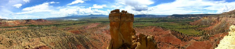
Pedestal Rocks (click image for a slideshow)

I awoke Friday morning to hear wind rushing through the air conditioner at the La Quinta as a gusty heavy rainstorm pummeled the area.  It had stopped by the time I finished breakfast and a check of the forecast told me that forty miles to the north, at the Pedestal Rocks trailhead, the rain should stop by 9 am with a window of dry weather for several hours.

That was good enough for me – I put on my new full-length hiking pants (with legs that zip off for conversion to shorts), my dried-out hiking boots, and set off to hike the Pedestal Rocks trail and, if the weather held, the adjoining King’s Bluff trail.

Arriving at the empty trailhead at 10 am, I found the rain had tapered off to an occasional drop here and there.  After crossing a bridge I was given the choice of which trail to follow.  My Hiking Arkansas book said the Pedestal Rocks trail was higher and dryer than King’s Bluff, so I set off down it with my silly umbrella hat on my head and no pack, for if a rainstorm arose I wanted to be able to move fast.

The foliage and the trail were quite wet, with Black-Eyed Susans popping out here and there.  I crossed atop a small waterfall, winding my way along the soaked trail until I reached a sign that said, “WARNING HIGH CLIFF AREA – Watch Your Children.”  That sounded promising!

I descended past a dripping bluff and then reached Arch Rock, which rose up two or three stories.  I couldn’t put myself in frame for scale, as I’d left my handy GorillaPod tripod in the pack back at the car.  Trudging onward, I saw my first pedestal rock, resembling a huge ice cream cone.  I managed to prop the camera up on a rock to give it some scale.  Later I came upon a viewpoint, obscured by clouds, but I took a seat for a portrait anyway.

The trail ran along the edge of a cliff with pedestals here and there set off a bit from it, and I couldn’t resist posing on one of its jutting edgesDescending to a trail below, I found that the underside of the cliff was riddled with caves, a welcome shelter from the rain.  I was careful in case any animals were taking shelter there as well, but I only encountered a fungus.

Walking through one cave I encountered a small waterfall off the cliff edge, and another stroll revealed a cave with a support pillar, which will some day become a pedestal after enough erosion has occurred.  I posed in a final cave before heading back up to the main trail, where I posed on the top of the cliff and appreciated one last pedestal set against the forest and the clearing sky.

On my return to the trailhead I encountered a beautiful prairie rose bush, which various insects were appreciating even more than I did.  But I was truly grateful to reach my car after spending 2.5 hours poking about the pedestals, as I was famished.  I found two vans had joined my car, although I had not spotted the arrivals, having had the entire trail to myself thanks to the weather.  Trail mix and a chocolate bar restored my spirits, as did the sun beginning to peek through the clouds.  I decided the weather would hold and, since the sun was coming out, it was time to slather on some sunscreen and bug repellent and tackle the King’s Bluff Trail.

The trail book was right, King’s Bluff was quite soggy.  But the sunlight cutting through the heavy clouds kept me going.  I encountered Dave and Eleanor, a couple who said there were two nice waterfalls ahead.  The trail soon opened out onto the expansive top of the bluff, towering over the forest below.  A creek to one side was swollen with rain, pouring over the side of the bluff in a lovely waterfall.  On the opposite side of the bluff I could hear a second waterfall from a creek which had eroded back the bluff considerably.

The trail crossed the creek and then led on around to a long eroded bluff with a great view of the forested hills.  The long cliff even had one or two more pedestals of its own.

Then the trail plunged back into the forest.  There I found a patient blue butterfly which happily posed for me, and the sunlight filtering down through tall trees warmed my heart…and my body.  It only reached 80 degrees on the trail, but the humidity was intense.  I’d hiked about five miles, what with the switchbacks to reach trails both above and below the cliffs.

I encountered a couple from New York who were headed onto the trails as I exited.  Noticing that the vans had left and a New York PT Cruiser was the only vehicle at the trailhead besides mine, I knew it was safe to disrobe.  I happily peeled off my soggy boots and clothes, stripping down to my underwear to wash off before putting on some fresh duds.

I then flew up and down and around the scenic mountain roads to reach Mountain View, home of the Ozark Folk Center State Park.  I checked into my cabin, which had a somewhat modern shape but quaintly furnished interior, with two walls of windows looking out onto the forest.  The trail mix had been digested long ago, so I strode up a steep hill to the park’s Skillet restaurant where I treated myself to a ribeye steak dinner.

Ozark Folk Center Performers (click image for a slideshow)

At 7 pm I was at the park auditorium for the live show, which featured square dancing, Mike Sutter of Mountain View on guitar, The Traveling Blueberries on piano, fiddle, and bass fiddle, banjo expert Clarke Buehling and dancing drummer Kent Bayette from Fayetteville, and down from Yellville there was Jimmy Joe Sasser and Friends playing guitars and fiddle with harmony singing.

Saturday it will be sunny and hot, and I’ll be headed to the ghost town of Rush and the Indian Rockhouse trail.

Click here for a slideshow from today’s day hike or click here for individual slides

Click here for a slideshow of the Ozark Folk Center show or click here for individual slides

Next hike: Rush and Buffalo Point –>

<– Previous hike: Pedestal Rocks and King’s Bluff

Posted in day hike, photos, travel, video | 3 Comments

Misty Mount Magazine

Misty Mount Magazine (click image for slideshow)

I started my day with breakfast at the La Quinta and hit the road, arriving in the Benefield Picnic Area on the southeast tip of Mount Magazine by 8:30 am.  It was overcast and I ascended into wispy clouds to reach the top.  The viewing today was even worse than yesterday and included rains throughout the afternoon, but I still managed to hike twelve miles, straddling yesterday’s day hike around the central portion of the summit with a 7.5 mile loop around the eastern part of the summit and a 4.5 mile loop out to the western edge.

I took the Benefield Trail first to the southeast edge of the mountain’s rim, where the trail ran to the east along the south bluffs overlooking the Petit Jean River over two thousand feet below.  The impressive bluffs had some wildflowers growing out of their sides, and I found berries on the trailside.  I then made my way through the unmown grass covering the trail over to the eastern side’s Sunrise Rock.  The view was greatly impaired by clouds, so I scrambled up past the upper bluffs over to Inspiration Point, where I could gaze north and see dim sunlight peeking out from under heavy clouds that were driving north past me.

I proceeded north via the Bear Hollow Trail along the mountain rim’s eastern edge, which is heavily eroded by Big Shoal Creek into two long arms stretching eastward.  I found spiderwort, blue trumpets, and other flowers growing along this trail, which afforded occasional glimpses across the way through the clouds but no decent shots.

Arriving at the horse camp on the mountain’s northeast tip, I headed west along its northern edge on Will Apple’s Road Trail, part of the first roadway that reached the mountain summit.  A side trail led down the mountainside to where a family once built a spring-fed swimming pool for their inn out of rock and tar.  The site was abandoned in the Great Depression and all I could recognize was a basin to capture the spring water up above the pool, which was a completely overgrown pit.  I didn’t bother to photograph any of it since the overgrowth was so thick, but I did like a purple coneflower along the Apple Road Trail and a zebra butterfly entertained me for awhile.

Arriving at the visitor center, I enjoyed a Sprite and some Peanut M&Ms since I had miles to go before returning to my vehicle.  I then repeated yesterday’s southward journey down the Greenfield Trail to the Mossback Ridge Trail, this time heading east back along Mossback Ridge toward the Benefield Picnic Area, rather than west toward the lodge as I did yesterday.  That completed a 7.5 mile loop as well as my The Big Short audiobook.  It was almost 12:30 pm, so I cleaned up and drove over to the lodge for a delicious country-fried chicken meal.

Heavier clouds were rolling in and the forecast said it would likely rain, but I really wanted to see the western part of the mountain and it is only accessible by hiking since the only road is closed to the public.  So I drove over to the Brown Spring Picnic Area, and located the unnamed trail that headed west along the mountain top’s northern rim.  A group of overflow tent campers were rapidly packing out, no doubt having heard that rain was a’comin’.  I threw my silly umbrella hat into my backpack and put on my alternate Tilley hat, one that is better sealed against rain than my usual one, and set out.

The trail was the least maintained one in the park, but still comfortable to walk in my hiking boots, although I did wonder if my insect repellent would suffice since I had not brought my long hiking pants.  The weather was wonderfully cool as I trekked past a field of wildflowers to a viewpoint looking northwest from the mountain.

Farther to the west I came across the “Window” viewpoint with a lone tree struggling to survive at the cliff edge.  The clouds were rolling in, and the forest became misty and quite beautiful.  Suddenly the trail popped out on a new road leading to a big antenna station.  Just as I reached the station the heavens opened up and a steady rain began.  I scrambled under the station’s northern eaves and waited for the rain to lessen.  It intensified, blown by winds, and I struggled in vain to get a decent radar image of the storm on my iPhone.  Data reception up on the mountain, outside of the lodge area, is spotty at best.

After 25 minutes the rain finally lessened and I put on my umbrella hat and ventured out, wandering about looking for a way to head on out to the mountain’s western tip.  I finally located the gravel road which is closed to the public, which the iPhone GPS showed to be making a straight shot westward.  Shielding my iPhone from the constant sprinkles with my Tilley hat, I trekked past one communication tower after another.  I lost count of how many stations dot this portion of the mountain, finally reaching the westernmost tip.  Reaching the rocky edge, I was disappointed but not surprised to find the view to the west completely obscured by mist and rain.  Reversing course back down the road, I used it to loop back to the Brown Spring area and conclude my hike.  I’d hiked another 4.5 miles, with half of that in rain.  My hiking socks were squishing in my sodden boots and I eagerly pulled them off and switched to tennis shoes for the drive back to Russellville.  That silly umbrella hat, however, had kept me fairly comfortable.

Hungry when I arrived in town during the rush hour, I used a wet washcloth to scrub away the insect repellent and sunscreen so I could dine at Joe’s Pizza and Pasta Italian Grill, where I had a delicious lasagna.  Then it was back to the La Quinta for a relaxing soak in the jacuzzi followed by blogging while the hotel hair dryer shrieked, drying out my boots.  I managed to get 19 miles of hiking in up on Mount Magazine over a day-and-a-half, which ain’t bad.

The forecast calls for more rain tomorrow, which may cancel my hikes on the Pedestal Rocks and King’s Bluff trails.  Perhaps the scattered thunderstorms will give me a break, however.  I’ll be heading northeast to Mountain View to stay in a cabin at the Ozark Folk Center.  At least its auditorium is enclosed, so I should be able to enjoy some music there even in wet weather.

Click here for a slideshow from today’s day hike or click here for the individual slides

Next hike: Pedestal Rocks and King’s Bluff –>

<—Previous hike: A Cloudy Afternoon Atop Mount Magazine

Posted in day hike, photos, travel | 1 Comment

A Cloudy Afternoon Atop Mount Magazine

Mount Magazine Lodge (click image for a slideshow)

My first real vacation of the 2010 summer break began today with a thunderstorm breaking out above Bartlesville as I fled south for yet another journey down the Muskogee Turnpike.  I finally left the rain behind as I exited the turnpike, heading east on I-40 into Arkansas.  I turned south at Ozark and drove to Mount Magazine on a cloudy and hazy afternoon that began in the 70s and reached up into the mid 80s.

I drove straight to the latest lodge, a $32 million structure which opened in 2006 and thus finally replaced a CCC lodge from 1940 which had burned in 1971.  It is a striking structure with a commanding view of the Petit Jean river valley 2000 feet below.  It has 60 guest rooms and, more important to me for this trip, a large restaurant.

The lodge featured another beautiful painted welcome sign like those adorning other Arkansas state parks I’ve visited this past year.  It is a nice touch and this tourist appreciates the effort.  I could see a hazy view of the river valley peeking behind the stone foundation of the lodge.  The poor viewing meant I would have little company on this Wednesday afternoon, which was fine with me as I was escaping from inservice and bargaining work which had preoccupied me since school let out over two weeks ago.

A few vintage vehicles were pulled up in front of the lodge, including a tiny yellow trailer even smaller than the little unit my grandparents towed about for years to raccoon hunts in southwest Missouri.  I especially liked one green machine, although I know it would not be half the car my trust Camry has been for me.

The big wooden double doors of the lodge silently swung open for me as I approached – the invisible doorman is another nice touch.  Familiarity breeds contempt: I take automatic sliding glass doors for granted but was surprised and gratified by this simple gesture.  I quickly made my way downstairs to the Skycrest Restaurant, which had only one couple by the big windows overlooking the valley, although some more groups joined us before I finished my tasty hamburger and fries.

Despite the nice viewing platform at the restaurant, the view was too hazy to delay me from my day hike.  I pulled on my hiking boots, inundated myself in sunscreen and insect repellent, swung up my baby backpack, and set off on a seven-mile loop around the central portion of the mountain top, which I tracked with my iPhone MotionX GPS app and later mapped in Google Earth.  The park’s trail maps, which I had previously downloaded to Dropbox for convenient access on my iPhone and iPad, were quite accurate.  I grabbed a hard copy at the lodge, which turned out to be not only more convenient for reading but also much better for fanning away bugs!

I ascended the Signal Hill trail to Arkansas’ highest point at 2,753 feet above sea level, where I indulged in a self-portrait, posing in one of my newly acquired UnderArmour wicking T-shirts and Magellan shorts.  The shirt worked fine today, but I should have stuck my wallet in the shorts when I was trying them out in the store – the deep back pockets smacked it up against the underside of my buttocks to my displeasure.  I had the front pockets too stuffed with the iPhone and a power supply (the GPS drains its battery very quickly) and my superzoom camera to accommodate the wallet, and the little backpack was bursting too.  So I had money on my mind much of the afternoon, alas.  I’ll try a different packing strategy for the rest of the trip.

There were no views on the wooded Signal Hill trail, which I followed for a mile to the Cameron Bluff campground, which I traversed.  A trail descends the mountain’s north face there to Cove Lake, 9.5 miles away.  I had no interest in rapidly losing and then later working hard to regain so much gravitational potential energy on that trail, opting instead for the North Rim trail, which headed eastward for over two miles to the park’s Visitor Center.

The views were limited from the leafy North Rim trail, although there were frequent glimpses of rock bluffs jutting out from the forest across the way and some views of the hills to the north.  I saw many ox-eye daisies and tickseeds (lance-leaved Coreopsis).  If you’re wondering about my sudden botanical expertise, I’ll confess that I bought a sturdy pocket guide to Arkansas trees and wildflowers at the park’s visitor center.  So I’ll speculate that I spied some Closed (and Open?) Gentian as well.

The view opened out big at the escarpment called Dill Point, where I exchanged greetings with the only other hikers I encountered on the North Rim Trail, two young men who looked like they could have used some wicking T-shirts as the temperature and the humidity soared.  My trusty Tilley hat was another advantage I had over them, although I doubt they considered it very stylish.

Soon I was at the visitor center where I enjoyed a cold Sprite while a butterfly posed nearby.  I then headed south down an old wagon road for 0.3 miles to Turkey Spring.  As I approached several frogs hopped off the rocks around the spring down into the water.  I could not coax them back out, although they did crawl out from the rocks and pop their heads up out of the water to keep an eye on me.  I was rewarded with another pretty plant on the southbound Greenfield Trail, although my pocket guide couldn’t identify it.

I then headed back west for over a mile along the Mossback Ridge Trail, which had grass growing up across the trail that thankfully wasn’t too tall for comfort.  This stretch of trail was a tad monotonous, as was my audiobook of the day, The Big Short by Michael Lewis.  It tells the story of various investors who made a killing selling short on the credit default swaps and similar real estate gambles of the recent housing bubble.  I was ready for a break from my other audiobook, The Subtle Knife, the second book of Philip Pullman’s His Dark Materials heretical fantasy trilogy.  But I think I perhaps went too far the other way.  It may be a relief when I finish up The Big Short on tomorrow’s day hike.

Arriving back at the lodge, I walked along its south side overlooking the Petit Jean River, where I found the Old Lodge Trail, a short loop down the bluff.  I found a rocky perch where I had a splendid panoramic view of forested mountain slopes descending to the river valley below.  My surroundings reminded me of my scrambles on the bluff at our vacation home above Table Rock Lake in the Ozarks, and I shut down the technology and settled in for a relaxed spell.

Sufficiently recuperated, I climbed back up to the lodge and walked eastward to the rock climbing area, where I found another short trail offering a glimpse of Blue Mountain Lake down below and nice examples of Queen Anne’s Lace, which is actually a domesticated carrot and often has a dark purple flower in the center of the lacy blooms.

I was then glad to return to the car and switch back to tennis shoes and allow the air conditioning to assist my wicking T-shirt as I drove on the Cameron Bluff Overlook Drive.  But I’d already seen the views from the various trails, so soon I was driving down the mountain’s south side, headed east to Russellville for my lodging.

I found my jacuzzi room waiting for me at the La Quinta, although I put off a dip in the tub until after a quick wash-up to prep for a yummy dinner at the Brick Oven Pizza Company.  Then I took my well-deserved jacuzzi break before embarking on a several hours of photo editing and blogging, with a slow upload to Flickr via the hotel’s weak WiFi.  I’m using my Asus Eee PC again for those tasks, although I used my iPad at the Skycrest Restaurant on its WiFi signal and at the pizza parlor, although it only had a slow AT&T Edge data connection, so I mostly read a book on the iPad there: Duchess of Death: The Unauthorized Biography of Agatha Christie by Richard Hack, who writes better than one might think from his name.

Tomorrow I’ll return to Mount Magazine for another day hike loop, this time on the eastern side of the rim.

Click here for a photo slideshow of today’s day hike or click here for individual slides

Next day hike: Misty Mount Magazine –>

Posted in day hike, photos, travel | 1 Comment

Mount Magazine Beckons

14 miles of trails atop Mount Magazine

Midway into next week I’ll be a full two weeks into my summer break and will have spent the equivalent of a full work week on school business. I spent a day at school helping other teachers, the equivalent of two more days leading contract negotiations, and next week calls for two more days at school leading some test development. Interruptions for school business will continue throughout the summer, so the only way to really decompress and get some true vacation time is to get out of town.

The weather is already quite warm, so I’m pining for a sixth summer trip to the cool Pacific Northwest.  But that would interrupt my long-term savings plan for a new car, so instead I’ll have to settle for some hot mountain hikes closer at hand. I could save a lot of money were I willing to camp out, but in this heat that doesn’t appeal to me one bit.

So in less than a week I’ll be heading back down the Muskogee Turnpike and I-40 to Arkansas. I greatly enjoyed circumnavigating Mount Nebo over Spring Break, so I’ve set my sights this time on Mount Magazine just west of there. It boasts the highest point in Arkansas, promises temperatures 6 to 20 degrees cooler than down below, and has a great lodge. I can’t afford to stay there, but I’ll certainly make use of its restaurant. For a nice shower, bed, and blogging support I’ll make use of a room an hour’s drive away in Russellville.

I am grateful to the lodge for its high prices in one way – they shifted my internal price meter. The heat had already shifted me from a $25 per day camp site to a $60 budget hotel room. But the prices at the lodge and the hour-long commute to escape them gave me mental permission to splurge on a jacuzzi-equipped room at a recommended hotel, since I told myself it was still $77 less per night than what a great suite up on Mount Magazine would cost.

I’ve bought some stronger insect repellent after picking up four ticks on a hike last week at Elk City Lake up in Kansas. As a kid I found ticks physically revolting, but now I just see them as a disease vector I need to dodge. And I’ll remember to carry a lot more water than what I was packing on my winter day hikes. Who knows, if I have enough fun in the sun I can always extend my stay in Arkansas for a few extra days…but at a budget hotel.

UPDATE:  I’ve decided to add two days to my trip, spending two nights in an inexpensive cabin at the Ozark Folk Center in Mountain View, where I can not only recover from my day hikes but also enjoy food and music in the evenings.  That will allow me to add hikes at Pedestal Rocks, King’s Bluff, Indian Rockhouse, Rush Mountain, and Tylers Bend to my Mount Magazine adventure.  That could add over 17 miles to my hiking total, hitting over 31 miles over the five days if I do them all.

Posted in day hike, travel | Leave a comment

A New Look

When I shaved off my beard on Halloween 2008, most people told me to stop frightening them and grow it back, which I promptly did for their sakes.  So I am cautious about altering my appearance, including my virtual one.

I shaved for Halloween 2008, frightening everyone

Nevertheless, MEADOR.ORG has changed its appearance many times since it went online almost 15 years ago.  For the first decade I called it Meador Manor and used a floorplan motif to organize it:

Meador Manor was open from 1996 until 2007

After a decade of handwritten HTML updates at the Manor and many other websites, I decided it was time to use online posting services to simplify my life.  It was too much effort to hand-code new ‘musings’ on my personal website and various news items on my websites for the high school and the BEA.  So I created the BHS News Feed and beaok.org on Google Sites.  Then I broke off into separate websites my collection of information on Bartlesville history and various school items, keeping them as hand-coded customized sites.

Finally I closed the Manor entirely, redirecting MEADOR.ORG to the online Blogger service, focusing it on my personal interests:

One of my Blogger themes

That worked fine, but Blogger wasn’t keeping up with the times and was too slow to add social networking features.  So I switched to WordPress, experimenting for awhile and settling on the three-column Garland theme:

My most recent WordPress theme

And then Facebook came along.  Hundreds of people befriended me there, so I knew I’d have to link it somehow to MEADOR.ORG.  And thus I import my blog posts as ‘notes’ on my personal profile at Facebook and export my Facebook links and status updates to FriendFeed, where I can then export them to Twitter and MEADOR.ORG.  That seems to work okay, although sometimes I have to refresh or rebuild the links to get things to update properly.

After Facebook added fan pages, I unsuccessfully tried to segregate my personal and professional life there by creating a public page where I stowed all of the Fluffy photos and the like.  I still post science-oriented things on the public page and offer it as a link on my bhsphysics.org website, but most people still befriend me in my personal Facebook profile instead of simply ‘liking’ my public page.

Meanwhile, I was increasingly dissatisfied with my WordPress site, thinking it was too busy.  But I couldn’t find another theme I liked better and so much more feedback came through the Facebook outlets that I didn’t pay much attention to updating the look of MEADOR.ORG.  However, the recent Facebook privacy kerfuffle reminded me that having my content hosted on a public service where I have more control is important – I certainly don’t want Facebook as the sole mediator of my personal web presence.

So I took another look at the WordPress galleries and found the relatively new Enterprise theme. I liked how it focused more attention on the blog posts and its default setting had a second menu line composed not of permanent pages but instead of post categories.  However, I did not care for its pop-up menus.  So I took a deep breath and switched to that theme on MEADOR.ORG.  Happily, I could use WordPress.com’s new Menu feature to customize both menus to my liking.

My latest WordPress theme

What next?  I’m happy with MEADOR.ORG but confounded by Facebook.  I make just about everything on my so-called personal profile there public, since it is obvious that you can’t trust Facebook to keep things private and folks keep befriending me there (630 and rising…).  But my public Facebook page has 380 people on it who aren’t my Facebook friends, so I’ll hang onto that as well, which means I’m now maintaining more websites than I can count on both hands.  That should be enough to keep me busy…

Posted in technology, web design | 1 Comment