Salt Plains

TRIP DATE: 10/8/2016 | SLIDESHOW | PHOTO ALBUM
Meador Post

A very busy start to the 2016-2017 school year has temporarily stalled the series of posts on our July honeymoon in the Pacific Northwest. So I’m interjecting here a post on our trip in early October to the Salt Plains.

Starting Fall at Osage Hills

The heat and bugs of summer keep us away from the trails, so Wendy and I have been eager for the cooler weather of autumn. The first weekend of October was finally cool enough for us to venture out for an initial hike after months of air conditioned captivity. We drove 30 minutes west to Osage Hills and walked the Creek Loop trail, which is still shown on the state travel website using my map. I knew we should take it easy, so we only did 2.14 miles on that relatively flat trail, visiting the bluffs above Sand Creek and making the loop through the woods. It was still a tad warm for our taste, but we definitely needed the exercise.

Selecting Our Next Hike

A week later the forecast high temperature was in the low 70s. So we made a long-delayed excursion to the Salt Plains. Wendy had enjoyed a solo visit to the area years before we started dating, and I had not been out there in decades. Wendy wasn’t interested in digging for selenite crystals, since she’d done that on her earlier outing, and I’m saving a dig for a future trip with our teaching colleague Betty Henderson, who loves digging for crystals in Arkansas and would no doubt love digging in the salt plains.

Crystal Hole

Instead, Wendy and I were focused on hiking and taking photos. I did my web research on trails and came up with two quite useful maps:

One trail I targeted was the Tonkawa Nature Trail in the northern area of the Great Salt Plains State Park, opting to avoid the much longer equestrian trails; I didn’t feel like navigating around horse droppings. I also marked down the Eagle Roost Trail, a five mile drive away from the state park over in the Salt Plains National Wildlife Refuge.

Enrique’s

Enrique's at the Ponca City Airport

I’ll confess, however, that a primary motivator in selecting the Salt Plains for our first real hiking trip of the fall was that midway along our journey out there we could stop for lunch at Enrique’s in Ponca City. That Mexican restaurant at the airport has great food in a unique setting. We headed out from Bartlesville by 10 a.m. so we could drive the 80 miles to Enrique’s by 11:30. US 60 west of Osage Hills is now a super-two road, with actual shoulders, which is much better than the shoulderless stretches of US 60 on either side of Bartlesville.

At the restaurant we ordered puffy chips with their spicy salsa for an appetizer. I had a beef chimichanga while Wendy opted for chicken and added a tamale. Our chimichangas were good, with savory beans and bacon and good rice for sides. Wendy loved the spicy salsa and puffy chips and said the tamale had the kind of heat she treasures in New Mexican cuisine, although it did not use green chiles. My more tender tummy took her word for it. The wonderful big lunch had both of us eager to get to walkin’.

Tonkawa Trail (A on the embedded Google map)

We drove another 70 miles east to the wildlife refuge headquarters, northwest of the state park. I was surprised to find the visitor center closed due an internal fire; there was no mention of this on their website. Later, on their Facebook page, I found out that in July they had a lightning strike that started a fire in the attic.

My soda at lunch had me eager to find a bathroom, so I drove us the five road miles through Nescatunga (which means “big salt water” in Osage) to the state park. We found a nicely plumbed bathroom there at the trailhead for the Tonkawa Nature Trail. The bathroom, however, was more impressive than the trail itself.

Tonkawa Nature Trail Track
Camping Area at Great Salt Plains State Park

The little trail winds through the trees for only a quarter mile, and it was littered with fallen branches. Clearly few folks bother with it, although near the trailhead is the Wildwood Chapel, a small group of railroad timber benches with a pulpit. I expect those who worship there pray for some relief from the biting insects that plagued the area during our brief visit.

There were large anthills all over the camping area. It is situated along the northern shore of the Salt Fork of the Arkansas as it spills out of the Great Salt Plains Lake. That lake is troubled, plagued by fish kills due to silting that has left it with an average depth of only two feet. There isn’t funding to dredge it, so it will likely just continue to silt in until it all becomes a wetland. As fish disappear from the low oxygen levels, so will some of the birds that flock to the area.

The lake hasn’t silted in fully, so we spotted our first large animal of the day: a pelican out in the Salt Fork of the Arkansas River below the spillway. We also admired the colorful layers of rock exposed across the river.

Pelican in the Salt Fork of the Arkansas

Eagle Roost & Hoot Owl Trails (B on the embedded Google map)

I was hopeful we’d have better hiking back at the Wildlife Refuge, so we made our way back to the Eagle Roost Trail near the closed Visitor Center. It is described online as a 1.25 loop near Eagle Roost Pond and Sand Creek Bay. We found the trailhead easily enough, just west of the visitor center.

Eagle Roost and Hoot Owl Trail Tracks

Wendy the rock hound immediately spotted some interesting rocks as we made our way through an area that clearly floods. I was surprised to soon reach a fork in the trail. To the left/south was the Hoot Owl Trail, something not mentioned on the Wildlife Refuge website, although they do have some shots from it on their active Facebook page. We headed down that graveled path to see where it might lead. It soon reached a T intersection, which I presumed was a trail loop. We headed to the left, only to find the trail branching again to the left, leading across a nicely built bridge. However, that rather nice bridge was quite overgrown, and the trail on the other side was untended, with tall plants growing out of the gravel. We’d sprayed ourselves with Cutter before heading out, but this looked treacherous in the bug department, so we returned to the main loop.

Satellite imagery shows the Hoot Owl Trail has been in place since at least 2012. The main Eagle Roost Trail is a mowed roadway, but for the Hoot Owl Trail they opted to lay down some fabric and then cover that with gravel. Plants have nevertheless contrived to penetrate the layers in many places, so maintenance is not as carefree as they might have hoped. The trail eventually looped back, and we were back on the mowed roadway as it led west across the marshland toward the eastern shore of Sand Creek Bay.

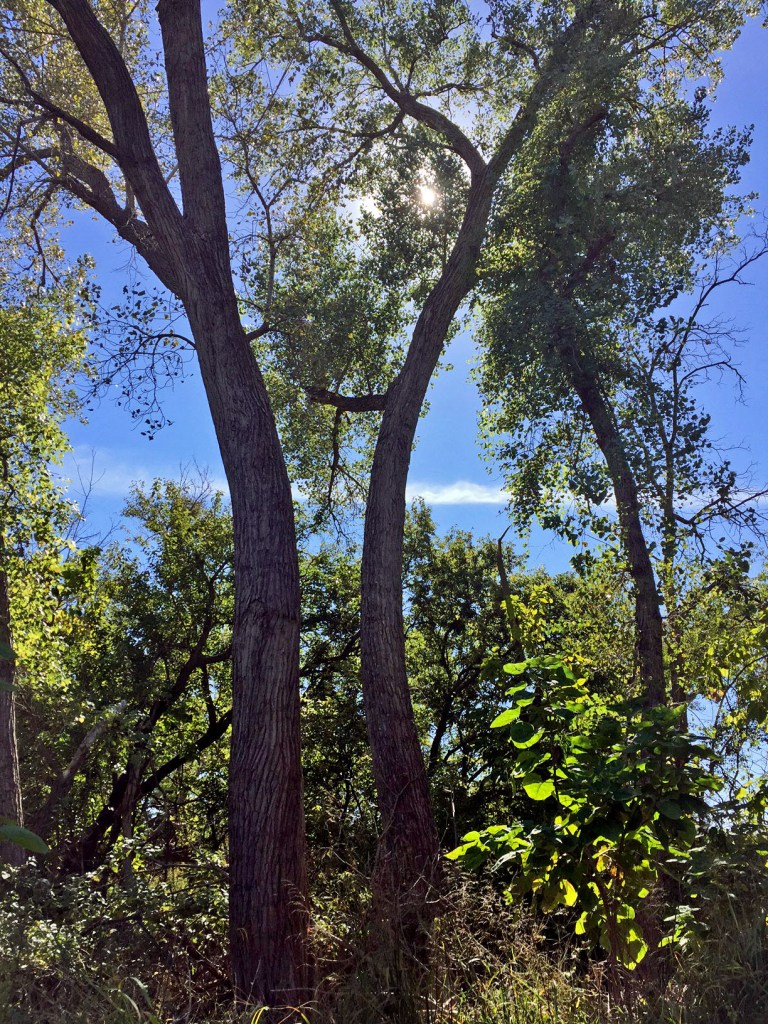
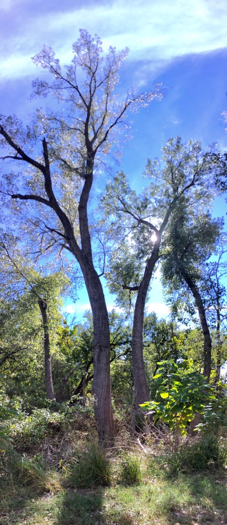
Bugs had feasted on the large leaves by the trailside, and we were certainly aware of the insect life in this marshy area, which had its share of swamp smell. Wendy pointed out two trees that were bowing towards each other. It is interesting to compare how the backlighting from the afternoon sun affected the shot her iPhone 6 produced in regular Photo mode with what my iPhone 6 produced when I took a vertical panorama. The panorama is less realistic, but is an arresting image.

Telescope View of Heron on Sand Creek Bay

On the shore of Sand Creek Bay was a nice blind which featured a telescope. I poked my Canon superzoom out of one slot while Wendy gazed through the telescope. Soon we got lucky with a blue heron swooping in to land among reeds out in the bay. I got a shot on the superzoom while Wendy enjoyed the even clearer view in the telescope, managing to get off an iPhone shot through the telescope.

The trail led north between the bay and the marshes to the east, choked with tall grasses and reeds. An armadillo ignored us as we trod past. At Eagle Roost Pond we didn’t spy any eagles, but a Monarch butterfly graciously posed for us. Wendy had already spotted a bald eagle on our drive toward Ponca City, so we couldn’t complain.

The roadway continued north, but the trail turned back east when we reached Puterbaugh Marsh. While I was grateful for the wildlife we’d spotted, I’d had enough of the marsh bugs and smells. So when the trail reached the auto route road on the eastern side of the loop, we exited the trail and walked back along the road to the car.

Harold F. Miller Auto Tour Route

The Miller Auto Tour Route is named after a local resident who devoted 38 years to the U.S. Fish and Wildlife Service. The route was planned in 1987, funded in 1989, and dedicated in 1992, and the road was in great shape. Soon after we began our drive, I saw a coyote dart across a field. Thankfully he stopped to look back at us, allowing me to capture him in the superzoom through Wendy’s open window. The road led by the rather unimaginatively named Little, Intermediate, and Big marshes. We passed an enormous old tree, with very thick grizzled bark. We took a final walk of 0.3 miles to and from the Casey Tower Overlook through the woods to what turned out to actually be another blind overlooking a field. Despite approaching as quietly as we could in our boots, we did not spot any wildlife. Dawn or dusk are better times to catch the critters in action.

Coyote

Searching for Salt (C on the embedded Google map)

It was time for some shots of the actual salt plains. I tried to spot the Sandpiper Trailhead off highway 11, which leads to an observation tower at the north end of the plains, but drove right past it. Rather than backtrack, I just drove on around through Cherokee, turning at the Selenite Sam sign to head along a county road to the digging area. We banged along the asphalt road, jounced by each seam in the old concrete roadbed underneath.

Selenite Crystal Digging Area

We finally bumped our way onto the salt flats, trading broken asphalt for mudholes. The thin layer of white salt coating the flat and barren 11,000 acres was initially deposited during repeated water level rises of a shallow sea millions of years ago. The supply of salt is kept intact by saline groundwater that flows just below the surface: when the water evaporates, a layer of salt remains. The same process helps form the selenite crystals which visitors dig for in designated areas which are rotated each year to allow for crystal reformation.

We pulled up to park beside dozens of vehicles at the dig area, which was pockmarked with shallow holes. Wendy and I roamed about, scavenging unclaimed crystals and rocks. I’m no rock hound, but I did manage to gather a handful of crystals. Wendy blended those with her own scavenged crystals and sparkling rocks, which she later cleaned up at home.

Scavenged Finds at the Selenite Digging Area

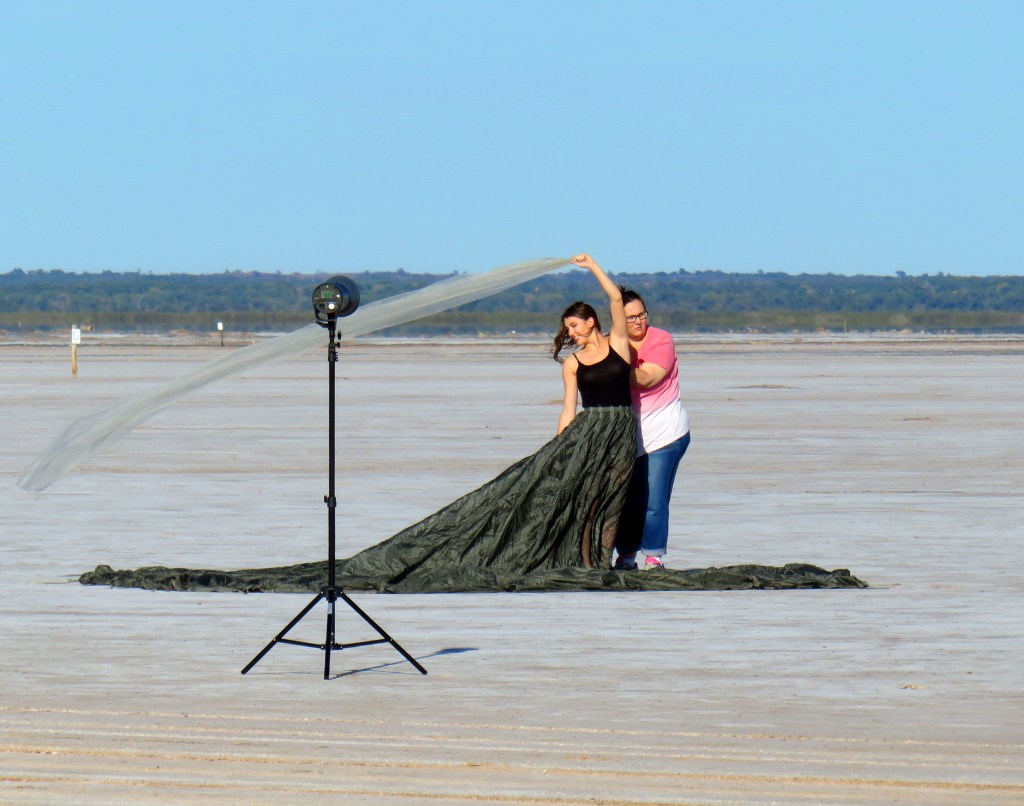
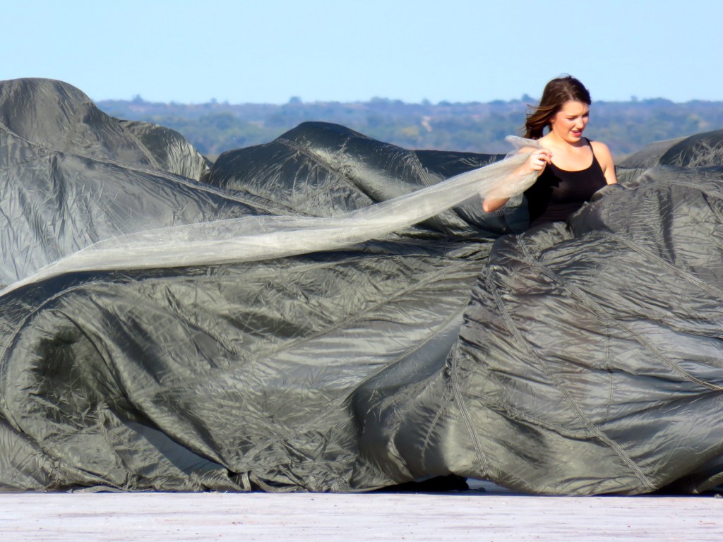
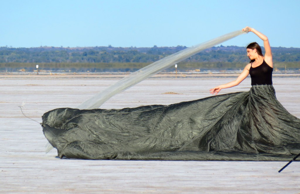
I got a kick watching some of the people out at the flats. Some little boys were having fun digging at one edge of the digging area. Across the road, photographers were busy with a model wearing an immense parachute-like skirt spread across the white flat. She held a gossamer streamer aloft in the breeze, but I think I like my blooper shot of her billowing skirt the best.

Headed Home

It was time to return to Bartlesville. TripAdvisor led us to stop off for dinner at the Garret Wrangler restaurant in Ponca City, but they were having an off night. Our turkey and dressing featured an underdone bird and lukewarm mashed potatoes, so I opted to forego a slice of pie. When we got home, it was time to remove the salt and grime. Wendy took a bath while I took the car over to the car wash to clean it, then returned home for a welcome shower. We had a great day out west and are looking forward to more hikes in the weeks to come.

SLIDESHOW | PHOTO ALBUM

Posted in day hike, photos, travel | Leave a comment

Honeymoon, Day 2: Downtown Portlandia

TRIP DATE: July 3, 2016 | SLIDESHOW | PHOTO ALBUM | Links to Honeymoon Posts

Meador Post

Our favorite hotel in OKC began as a Cambria Suites
Our favorite hotel in OKC began as a Cambria Suites and is now a Doubletree by Hilton

I suppose our first honeymoon hotel was technically in Oklahoma City, since we spent the first night at our favorite place to stay in OKC: the Doubletree by Hilton near the airport. It is only a 15 minute drive from there north along Meridian Avenue to my parents’ home in the Windsor Hills neighborhood. When we first began staying at the hotel, it was a Cambria Suites. We liked its room décor, spacious bathrooms, and luxurious bedding. “Suite” is used loosely by hotels these days; I don’t regard a separate area for the bed that only has a divider instead of a real wall and door to actually qualify as a suite. These days I usually book us in a real suite with separate bedroom since Wendy is a night owl who likes to stay up later than I do.

The new carpet at our hotel

Hilton bought out the hotel later and only slightly changed the room décor. Lately they’ve been ripping apart the dining area, lobby, and hallway carpeting. (What is it with hotels’ carpeting? Is there a law that it must be incredibly ugly? I know they are trying to disguise heavy traffic patterns, but I’ve only seen a few examples of nice-looking hotel carpet. The Doubletree’s new corridor carpet, which looks like a signal wave pattern, is not one of them.) It is a testament to the hotel’s room design that we’ve continued to stay there even with that mess, including road delays as a long stretch of Meridian Avenue is being reconstructed south of Interstate 40.

Our "mini-suite" in Troutdale
Our “mini-suite” in Troutdale

In my mind, our honeymoon really began in the Pacific Northwest. We spent the first four nights at the Best Western Plus Cascade Inn & Suites in Troutdale. It also isn’t honest about “suite” – calling an extra long room narrowed in one spot by short wall segments a “mini-suite” is stretching the truth. But I still booked the room there because everything in liberal, popular Portland is expensive, particularly the hotels. I avoided the pricey downtown hotels with their valet parking and instead picked the Best Western over in Troutdale. We like Best Westerns, so long as they have interior corridors, because they are usually clean and fairly quiet and not too hard on the wallet.

I picked Troutdale because the hotel was close to the airport and near the western terminus of the historic Columbia River Gorge scenic highway. Wendy the night owl doesn’t prefer to get up early, and for the day we planned to take that long scenic drive, I did not want us to waste a lot of daylight threading our way through Portland over to the old scenic road.

But the big draw for Wendy in Portland was the International Rose Test Garden. We had thought we’d do that on Sunday, our first full day in the area, but reconsidered since Google said Mondays had far fewer visitors than Sundays. Now, mind you, the Monday in question would be the Independence Day holiday, but we opted to wait. So our first full day in the Portland area was spent downtown visiting the regular Portland Saturday Market (which also operates on Sundays) and Powell’s City of Books, making a stop at the Mount Hood viewpoint in Mount Tabor Park, and walking the trails of Glenn Otto Park in Troutdale.

Things Were Smokin’ at the Market

Portlandia is a comedy show set in the city

There’s a reason they make a sketch comedy television series in and about Portland, called Portlandia. The Pacific Northwest, especially Portland, can be as laughably liberal as Oklahoma and the states to the southeast of it can be comedically conservative. I prefer the former, but live in the latter. But I do have my limits, and the stink of reefers that was wafting throughout areas of downtown Portland was unwelcome to my nostrils. My very conservative home state has repeatedly failed to produce enough signatures for ballot initiatives to promote even medical uses of marijuana, although neighboring Colorado has recently legalized it for recreational use, as have Alaska, Washington State, and, of course, Oregon.

So Wendy and I were taken aback to see stores across both Oregon and Washington, dispensaries emblazoned with green crosses advertising marijuana. As teachers who are supposed to be alert for misbehaving students, our drug detecting senses were alerting pretty often in downtown Portland.

It was a 15 mile drive westward from our hotel in Troutdale to Portland’s Old Town, which lies along the western shore of the Willamette River. But we made a detour in our rental Nissan Sentra to a Biscuits Cafe in Gresham for a late breakfast. The place was very busy, and the food explained why.

We then crossed the Willamette to visit the Saturday Market, which is mostly folks selling hand-made arts and crafts. In quest of a restroom, we threaded our way through the event for relief. Then we could weave our way amongst the stalls. My favorite was intricate framed string art by Pterylae Designs. I noted that some of the food booths were backed up against a Municipal Sewage Pumping Plant. It seemed efficient, if not appetizing! I snapped a busker making a wild Independence Day hat for a youngster and enjoyed getting a shot of the streetcar tracks angling along 1st Street near Skidmore Fountain.

The City of Books

Found a guy who got lost in Powell's City of Books

A visit to downtown Portland is not complete without touring Powell’s City of Books, the largest used and new bookstore in the world. The original location in the Pearl District on Burnside takes up an entire city block. Its nine color-coded rooms together hold about one million books, divided into a staggering 3,500 sections. The store’s parking garage was full, so we parked a block away in an underground lot that let us exit through a Whole Foods Market.

Wendy bought a few books on roses, naturally, while I hung out with a guy who was so overwhelmed that he forgot to eat. I enjoy browsing a bookstore, so when in Tulsa I’m careful to buy magazines and picture books and the like at Barnes and Noble to help keep them going (I so miss Borders!). But regular readers of the blog know that since 2008 I have preferred reading books on a long line of e-ink Kindles; my current and fifth Kindle is their Voyage model. On this trip it was very nice to be able to quickly shift about to continue reading a book on the Kindle, then my iPad, and even sometimes on my iPhone. And it was pretty darn nice to get to read some books, for that matter. Back home I’m always inundated with school-related work, so the honeymoon was a great chance to instead concentrate on relaxing and touring with my bride.

On the way back to the car, we stopped in at Storables, where Wendy enjoyed browsing. We’ve had home organization on our minds a lot recently, with her moving into Meador Manor from her nearby apartment. She is a tremendous organizer. I’m pretty organized in some ways, but Wendy puts me to shame.

Mount Hood from Mount Tabor

One of my discoveries on a previous trip to Portland was the nice view of Mount Hood from Mount Tabor Park a few miles due east of downtown Portland, on the other side of the Willamette River. The city fathers built a park and reservoir up there, not realizing they were building on an extinct volcano. The Tabor cinder cone is part of the Boring Lava Field, an extensive network of cinder cones and small shield volcanoes ranging from Boring, Oregon to southwest Washington, and dating to the Plio-Pleistocene era. The lava field has been extinct for over 300,000 years, and the cinder cone now rises about 400 feet above the surrounding landscape, providing a nice view of Mount Hood, the huge snow-capped stratovolcano 45 miles away to the southeast. Mount Hood’s last major eruption was 230 years ago.

Mount Hood viewed from Mount Tabor, 45 miles away

Dinner and a Walk on Cold Ashes

Dinner was at another chain restaurant, a Shari’s, where we enjoyed following our entrées with pie; Wendy particularly liked her slice of marionberry pie. We needed to walk after all of that food, so I drove us back to our hotel in Troutdale and then explored the roads east of there, discovering the western terminus of the Columbia River Gorge Scenic Byway which we’d be driving along in a few days. It led through downtown Troutdale and passed Glenn Otto Park right before it crossed the Sandy River. The park is nestled between that river and Beaver Creek. It was clear from the folks striding through the parking lot that the park afforded river access and had some trails, so I pulled in.

First heart rock of the honeymoon

I had told Wendy that one odd thing about hiking in the Pacific Northwest is how you always find yourself treading on ash and other volcanic debris. This was a great place to illustrate that. We took off down a trail, noting the ferns and other vegetation unfamiliar to us plains folk. Wendy marveled at the abundant ivy as we found various trails leading to the Sandy River. Folks were out enjoying the cool water, floating by and yes, smoking weed.

Wendy the rock hound had a blast looking at the rocks and found a heart rock pretty quickly. The sand was really just ash, and some rocks were quite volcanic in appearance. Across the river I could hear folks dining on a restaurant patio.

The following day we’d return to Portland to tour the International Rose Test Garden.

SLIDESHOW | PHOTO ALBUM

Honeymoon, Day 3: International Rose Test Garden >

< Honeymoon, Day 1: Planning for Portland and Beyond | Other Honeymoon Posts

Posted in art, photos, travel | 3 Comments

Honeymoon, Day 1: Planning for Portland and Beyond

TRIP DATE: July 3, 2016 | SLIDESHOW | PHOTO ALBUM | Links to Honeymoon Posts

Meador Post

NOTE: I’m extremely busy this summer “break” with oodles of school-related projects, so I considered limiting my blog posts on our honeymoon to brief highlights. But Wendy and I only get one honeymoon, and I want a record we can enjoy in our dotage. So I’m opting for my old-fashioned detailed day-by-day approach, which means this will be a quite lengthy series of posts. Plus my busy schedule means I’ll have to space them out over many weeks to get them all in with the many linked photos. I hope some of our Gentle Readers will find the wait worthwhile and enjoy the nitty gritty travel details. We sure enjoyed our trip!

Wendy and I have traveled together extensively in Oklahoma and Arkansas for various hikes and vacations. We’ve also fled Oklahoma’s weather extremes with ventures into Texas during winter breaks and to Colorado and the higher elevations in New Mexico in summer. But I had never taken her to my favorite summer vacation area: the Pacific Northwest (PCNW).

Wendy and Granger's Travels, 2013-2016

Longing for the Pacific Northwest

Hiking at Mount Rainier

My love for the Pacific Northwest as a summer destination began in the late 1990s. I had won free plane tickets to anywhere in the continental U.S. as the district teacher of the year. My criteria for selecting a destination was to a) go as far away from Oklahoma as possible, b) go somewhere cool during the hot Oklahoma summer, and c) go somewhere I had never been before. So I invited a teaching colleague to go with me to the PCNW. It is a coincidence that her name was Wendy, as that was years before I met my future wife. We visited Seattle, the Mount Saint Helens volcano, and both Victoria and Vancouver in far southwestern British Columbia. It is a lovely region in the summer with bright but cool days, beautiful vegetation, and friendly folks.

I enjoyed that visit to the cool and beautiful PCNW so much that I returned to Seattle in 2005 on a solo outing, and then made another solo trip to Oregon in 2006, driving and dayhiking along the Columbia River Gorge and all of the way down Oregon’s open coastline from Astoria to the redwoods of northern California. In 2008 I again received the free-tickets deal when I was honored for the second time as the district teacher of the year (a recognition I will soon be immune from), so I returned to Washington state and British Columbia. The following year I made a second dayhike-oriented trip to Oregon. So it is little surprise that I decided we should splurge on our honeymoon and visit Oregon, Washington, and Victoria, BC.

Planning for Portland and Beyond

I’ve never driven from Oklahoma to the PCNW and never plan to do so. The trip is about 1,900 miles by car, taking about 28 hours of driving time. I used to be willing to drive as much as ten hours in one day, but I’m far too old and too wise to do that now. Five hours of driving in a day is pushing it for me these days. So we’d be flying out, which meant dealing with all of the restrictions and fees on baggage that have arisen since the last time I flew on a plane in 2009.

Airplane seats have really shrunk in coach, so we splurged on First Class

Wendy had flown before, with her first flight back in 1990 when she was flown out from Dallas to Washington, DC to compete as the northeast Texas champion in the National Spelling Bee. (Thankfully, I can spell pretty well: I tied for first place in a written spelling test at a state scholastic meet in high school, but my wife is even better at it.) Wendy was apprehensive about the long flight, and I too dreaded narrow seats with little leg room and the possibility of squalling babies. So I looked into paying various fees for extra bags, wider seats, seats with more legroom, etc. By the time I had seats in coach that I thought we could live with, the fees had piled on to where we might as well try a different tactic. So Wendy and I flew in First Class on all three of our plane flights for the honeymoon: Oklahoma City to Dallas and then Dallas to Portland on American Airlines and later Seattle-Tacoma to Oklahoma City on Alaska Airlines. Thus we always shared a lone row of two side-by-side wide seats with plenty of legroom and could each check two bags for free, so long as they each weighed less than 50 pounds.

Even with that luxury of an extra checked bag for each of us, the length of our honeymoon meant that we needed to plan our trip to include a couple of laundromat days. I was determined to hit several highlights: Portland’s International Rose Test Garden for my rose-loving wife, the Columbia River Gorge scenic highway, Ecola Point and Astoria on the Pacific coast, Mount Saint Helens and Ruby Beach in Washington (our friend and fellow teacher Gary Layman clued us in on the latter), and Victoria, British Columbia’s Inner Harbour and the nearby Butchart Gardens. Driving around to enjoy all of those places without having to pack in and out of a hotel every day extended our honeymoon to 17 days. That’s the longest trip Wendy and I had ever taken, and mid-trip we agreed that our future vacations will likely be 10 days or less. We got along fabulously, but two weeks or more on the road is a bit much.

Honeymoon Map

Security! Security!

Unlike my wife, I’m a morning person. Left to my own devices, I’ll get up at 7 a.m. or earlier and run hard until I head for bed around 10 p.m. Wendy would much rather sleep later and stay up late. So I decided to avoid morning flights from Oklahoma City to Oregon on the day after our wedding. Back in February I booked us on planes that would fly us out of Oklahoma City at 2 p.m. Central Time, switch planes at the Dallas hub, and land in Portland, 6.5 hours after our first flight took off, at 6:30 p.m. Pacific Time. But those flights were cancelled and we were shifted to fly out of OKC at 4:24 p.m. Central Time and not arrive in Portland until 9 p.m. Pacific Time. Arriving in Portland at what would feel like 11 p.m. to us wasn’t ideal, especially with us needing to pick up a rental car, but I’d booked a hotel in Troutdale that was only a 15 minute drive from the airport, so we’d cope.

A typical TSA screening line

Wendy’s last flight had been prior to the 9/11/2001 terrorist attacks, so she’d heard about but never experienced TSA security screening at airports, with its scanners, fluids restrictions, shoe removal, and the like. We were dreading it a bit, given that long delays, due to typically poor planning and implementation by the TSA, had led to long delays at major airports in the spring and early summer. Wendy is a careful planner, so she’d researched all of the fluids regulations and the like and done her best to pack legally and efficiently. My airport worries were more focused on baggage; I’ve had a bag exceed weight limits before and have had to scramble to avoid nasty fees. So I was using my bag weight scale and re-packing to keep my big rolling suitcase under the 50 pound limit.

I drove us and my parents out to Will Rogers World Airport in one of my parents’ cars; they would come pick us up at the same airport when we returned from our honeymoon. When I was a child, my father would sometimes take me with him out to the airport to pick up natural gas measurement graphs flown in from field stations (there was no internet nor wireless technology for field recordings back then). I was always excited to go out there with him, eager to visit the “control tower” and listen to the air traffic controllers — it was actually a shorter tower with speakers playing the feed from the real control tower. So I had fond memories of the airport, but had not flown out of there in decades. So I was interested to see how much it had changed.

Will Rogers World Airport in Oklahoma City is quite pleasant

There are now many more parking lots at that airport, and the interior is still recognizable in shape but has updated finishes. Our flight was taking off from an extension off the main terminal I had not visited before. The Oklahoma City airport on that Saturday afternoon was mostly empty, and check-in was quick and easy. We had only a short wait at the TSA security screening, albeit Wendy encountered a gruff screener:

Wendy approached the body scanner, and this lady asked her, “Do you have anything in your pockets?”

Flustered, Wendy tore through her pockets, looking for anything metal that might be problematic. She only found some gum and pulled it out, saying, “Oh, uh, I have some gum.”

The lady barked at her, “That’s a thing.”

Well, yes, but we’re stressed too, okay?

Two days earlier I had my own run-in with security. We had to go to the Oklahoma County Courthouse to get our marriage license, and the security officers would not let me in with the tiny key tool I had not thought to remove from my key ring before walking several blocks through the simmering sun to the building. (The streets around the courthouse were either blocked by construction or lacked open parking. Well, Wendy points out that as I tried to navigate the confusing streets I failed to take advantage of closer parking spots she spotted and mentioned to me, but that goes without saying. Men don’t listen!) The officer said, “Believe it or not, we can’t let you in with this.” Then he gave me the option of taking it back to my car and returning, or having him confiscate it permanently. So he could store it for disposal, but not simply hand it back to me as I left a few minutes later. Seething, I let him take it. The TSA has a similar policy, although theirs makes much more sense in a crowded airport than the same policy at the quiet entrance to the courthouse. In the case of the TSA, the confiscated items are sold off.

Thankfully Wendy got through the airport scanner without triggering it, so we put our shoes back on and grabbed our items that had gone through the belt scanner. Then we moseyed through the long curving terminal to our gate, which was at the end of another long terminal extension I had not seen before.

The Flights to the PCNW

Our first flight was on one of American's Bombardier CRJ900s
Our first flight was on one of American’s Bombardier CRJ900s

Our flight from Oklahoma City to Dallas was on a smaller Bombardier CRJ900, rather than the Boeing 737 or McDonnell Douglas MD80 jets I was used to flying out of Oklahoma on American Airlines in all of my previous flights. The plane was fairly comfortable, especially in First Class, although on our flight to Dallas the air conditioning was not functioning well, so we were warm, but not nearly as uncomfortable as the flight attendant.

The connection at Dallas-Fort Worth went well, with us finding time to grab dinner at a TGI Friday’s in the airport, since we weren’t too sure about the entrées we had reserved for our long evening flight to Portland. That four-hour flight was on a larger Boeing 737-800, a style of plane which filled the gap when the venerable MD80 went out of production after McDonnell Douglas merged with Boeing. We liked that older and wider plane better than the Bombardier.

We enjoyed First Class on the 737-800 to Portland

We had a seasoned, expert flight attendant who took good care of us. I don’t think I’ve ever flown First Class; I certainly have never paid for it but might have been upgraded once on a short flight. So I was pleasantly surprised by the warm wash cloths, heated nuts, and other little touches we were spoiled with. Our entrées turned out pretty well, although I’ve also had good food back in coach. I purchased WiFi access for each of us through the Gogo service, so we could track where we were at along the flight and could access many internet services, although streaming video was out of the question. We mainly kept ourselves entertained with Kindle books: Wendy was reading Honky Tonk Samurai and I was finishing Ellison’s Invisible ManI was startled to see some stills from Claude Rains’ Invisible Man movie inserted into the text; some editor had foolishly confused Ralph Ellison with H.G. Wells! That oversight only drove home the point of Ellison’s masterwork on issues facing African Americans.

I always gave Wendy the window seat, both out of chivalry and because I’ve flown several times since she took a flight. So she had fun looking out at the passing clouds, wind farms, rivers, and mountains. It was thrilling to see magnificent Mount Hood to our left as we flew into Portland. I knew we’d be seeing it from ground level from Portland and again, closer up, a few days later when we drove along the Columbia River Gorge.

Passing Mount Hood

Our flight ended with a mint, served on a tray with a glass bubbling vapor in fun recognition that we had landed in the Cascade Range. We would start near volcanic Mount Hood, later drive partway up Mount Saint Helens to view the caldera where it erupted in 1980, drive over by Mount Rainier, and circumnavigate the Olympic peninsula, with Mount Olympus at its distant center. There are massive volcanoes all over the PCNW, and we would repeatedly note how we were walking about on ash. It is a sobering reminder how that lovely, moist, and cool region is on occasion wracked in volcanic violence with fiery fury. Thankfully all of the mountains remained dormant throughout our honeymoon, which would commence in earnest the following day with us visiting downtown Portland.

SLIDESHOW | PHOTO ALBUM

Keeping It Simple (Our Wedding) | Other Honeymoon Posts

Posted in photos, travel | Leave a comment

Keeping It Simple

Links to Honeymoon Posts


At age six, I was a ring bearer at a wedding

At age six, I was a ring bearer at a wedding

Meador PostThis month I am turning 50 years old. At my age, a birthday requires relatively little planning. I’m content to share some time with my closest friends. When asked what I might like for a gift, I can honestly say their company would mean more to me than any other gifts they might bestow.

But I started this month with getting married for the first time, and a wedding requires much more planning. The most elaborate wedding I’ve participated in was when I was a ring bearer at age six, decked out in a white tuxedo with a yellow ruffled shirt; yes, it was the 1970s. I remember how the rings were tied to the pillow I held, so I wouldn’t drop them as I fidgeted through what seemed an interminable ceremony. Wendy, my beautiful bride, remembers being a train bearer at her older sister’s ceremony in the 1980s. Those early experiences formed our childhood impressions of what weddings were like.

When faced with planning our own wedding, we realized that at our stage in life we wanted to dispense with almost all of the usual fanfare. We did want to involve my parents, so we opted for a ceremony near their home in Oklahoma City. Rather than burden our friends in Bartlesville and Tulsa with a long road trip to attend a wedding, we kept the ceremony very small and simple. A high school friend, with whom we had connected at my 30-year high school reunion a few years back, kindly offered to be our officiant.

We brought our own roses since Oklahoma City no longer has a rose garden

We brought our own roses since Oklahoma City no longer has a rose garden

I know that, at age 49, I was very lucky that both of my parents could be there

I know that, at my age, we were very lucky that both of my parents could be there

With one of my uncles and his family graciously assisting, we were only a party of eight at a gazebo at Will Rogers Park. We had booked the park since Wendy loves roses, and it was the home of the Sparks Rose Garden. However, we later discovered that a blight wiped out the roses some years back, and it is now the Sparks Color Garden. One thing we Oklahoma teachers know is how to adapt to shortcomings, so in addition to a rose corsage and boutonniere, I surprised Wendy with a bouquet of large red long-stemmed roses in a tall vase that was front and center for the ceremony.

I’m frankly flabbergasted that the average wedding now reportedly costs $25,000 to $30,000. Do most couples take out a loan these days? Our wedding certainly did not cost much. Wendy is even more frugal than I, so we were both content to only have to pay for our wedding outfits, the roses, and the park rental. Our engagement rings became our wedding rings. My folks bought us all lunch afterward, with my father offering a toast that fit us to a T, as in trails:

Tapping on a glass I would like to raise a toast to the newlyweds. Here’s to Wendy and Granger: Using a phrase, not coined by me, but one seen many times in your posts and blogs, Charli and I wish you many Happy Trails as you begin a great new adventure together.

Our wedding reflected our relationship: simple, loving, and direct. Our honeymoon, however, would be a bit more elaborate. We would stay in eight hotel rooms over 18 days in three different states and one foreign country, traveling over 3,300 miles by plane, 1,200 miles by car, and 50 miles by ferry. Our travels will be the subject of the next posts.

Our wedding included no gift registry, as we aren’t youngsters just starting out. We also had no reception but plan to have an informal get-together at the lake with friends. We recognize that for us what matters most in life are people, not possessions. I am grateful for my parents, my extended family, my friends and co-workers, and, most of all, for my beautiful wife. I agree with the sentiment on a shirt Wendy received at a bridal shower: “Happy wife, happy life.”

Granger and Wendy Meador

Granger and Wendy Meador

Honeymoon, Day 1: Planning for Portland and Beyond >

Other Honeymoon Posts

Posted in photos, roses | 4 Comments

Kite Trail Wildflowers in the Wichitas

Hike Date: May 14, 2016 | SLIDESHOW | PHOTO MOSAIC
Meador Post

Wendy and I spent much of the spring working on Meador Manor to prepare it for her move here in late June before our marriage on July 1. That meant we were unable to hike on multiple weekends, save for brief outings on familiar trails at Skull Hollow and the bike trails at Osage Hills. But in mid-May we did manage to hike a trail new to both of us: the Kite Trail in the Wichita Mountains Wildlife Refuge.

We took a break from housework to visit Lawton, in southeast Oklahoma, where Wendy’s brother was stationed at the Fort Sill army base. He and his family would soon be transferred to the east coast, so we met up with them for lunch. Then Wendy and I took advantage of our proximity to the wildlife refuge to take a nice walk.

I selected the Kite Trail, which is part of the Dog Run Hollow Trail System which I visited on Christmas Day in 2010. On that previous outing I had come in from the north and trekked south on the Bison Trail on the west side of West Cache Creek as far south as the canyon called the Forty Foot Hole. This time we would start from the south on the Kite Trail, which heads along the east side of West Cache Creek to Lost Lake and then back, in what turned out to be a very pretty 2.75 mile hike. In the future, I’ll favor the Kite Trail over the Bison Trail, although the challenging Narrows Trail farther east remains my favorite.

Indian Blanket

We took Highway 62 west from Lawton to Cache, and then drove north on 115 into the refuge. Turning west on 49, the main road in the western part of the refuge, we passed Quanah Parker and Burford Lakes before turning south to drive past Lost Lake and finally dead-end at the Boulder Picnic Area. At the farthest end of the loop is the Kite Trail’s south trailhead.

Wendy and the Wildflowers near West Cache Creek
Indian Blanket

The vegetation was lush and green from recent rains, so I expected the creek to be running well. We were happy to find the granite hillsides covered in flowers, including large numbers of Indian Blanket, which back in 1986 was designated as Oklahoma’s state wildflower. As we travelled north near the creek, we encountered Indian Paintbrush, Spiderwort, Purple Poppy Mallow, many more Indian Blankets, and fields of yellow flowers.

I posed on the trail as we approached the Forty Foot Hole, with small waterfalls visible below us in the creek just south of the canyon. Then we reached the Forty Foot Hole.

Forty Foot Hole from the south end
North falls detail

This crevice carved by the creek is quite beautiful, with more falls on its north end. Some adventuresome boys provided scale in a photo and a brief video, and I shot a close-up showing the vertical bedding planes. As Wendy and I snacked above the falls, more young hikers passed by and made their way down. I got a shot of the Forty Foot Hole from its north end, with more falls to enjoy.

We travelled onward through the wildflowers, occasionally guided by old metal markers that revealed the Kite Trail is named for the bird, not the wind-borne toy. While Wendy took snaps of more wildflowers, a lizard carefully posed for me on the rocks. Wendy accidentally pressed the wrong button on her iPhone, but I liked the resulting Ansel Adams-style photograph of me shooting amidst the granite confusion.

Lizard

Farther upstream, a large smooth boulder in the creek urged contemplation. A tree had thick bark that reminded me of scales, and there were prickly pear cactus blooms beginning to open. Wendy got a nice shot of some impressive Antelope Horns milkweed. Near Lost Lake, water running off a granite slab had brightened the vegetative border.

We passed the Lost Lake dam, and nearby sharp-eyed Wendy spotted a beautiful Catclaw Sensitive Briar bloom. We headed for the picnic area and a welcome bathroom break before turning back.

High flower path

The view back toward the dam made it resemble a huge mirage pool. I steered us on a higher side trail for some variation on the way back, with us blessed by more wildflowers strewn along the way.

It had been a wonderful hike, something we could both reflect back on over the next few hectic weeks as we brought the academic year to a close.

SLIDESHOW | PHOTO MOSAIC

Posted in day hike, photos, travel, video | Leave a comment