This month I am turning 50 years old. At my age, a birthday requires relatively little planning. I’m content to share some time with my closest friends. When asked what I might like for a gift, I can honestly say their company would mean more to me than any other gifts they might bestow.
But I started this month with getting married for the first time, and a wedding requires much more planning. The most elaborate wedding I’ve participated in was when I was a ring bearer at age six, decked out in a white tuxedo with a yellow ruffled shirt; yes, it was the 1970s. I remember how the rings were tied to the pillow I held, so I wouldn’t drop them as I fidgeted through what seemed an interminable ceremony. Wendy, my beautiful bride, remembers being a train bearer at her older sister’s ceremony in the 1980s. Those early experiences formed our childhood impressions of what weddings were like.
When faced with planning our own wedding, we realized that at our stage in life we wanted to dispense with almost all of the usual fanfare. We did want to involve my parents, so we opted for a ceremony near their home in Oklahoma City. Rather than burden our friends in Bartlesville and Tulsa with a long road trip to attend a wedding, we kept the ceremony very small and simple. A high school friend, with whom we had connected at my 30-year high school reunion a few years back, kindly offered to be our officiant.
We brought our own roses since Oklahoma City no longer has a rose garden
I know that, at my age, we were very lucky that both of my parents could be there
With one of my uncles and his family graciously assisting, we were only a party of eight at a gazebo at Will Rogers Park. We had booked the park since Wendy loves roses, and it was the home of the Sparks Rose Garden. However, we later discovered that a blight wiped out the roses some years back, and it is now the Sparks Color Garden. One thing we Oklahoma teachers know is how to adapt to shortcomings, so in addition to a rose corsage and boutonniere, I surprised Wendy with a bouquet of large red long-stemmed roses in a tall vase that was front and center for the ceremony.
I’m frankly flabbergasted that the average wedding now reportedly costs $25,000 to $30,000. Do most couples take out a loan these days? Our wedding certainly did not cost much. Wendy is even more frugal than I, so we were both content to only have to pay for our wedding outfits, the roses, and the park rental. Our engagement rings became our wedding rings. My folks bought us all lunch afterward, with my father offering a toast that fit us to a T, as in trails:
Tapping on a glass I would like to raise a toast to the newlyweds. Here’s to Wendy and Granger: Using a phrase, not coined by me, but one seen many times in your posts and blogs, Charli and I wish you many Happy Trails as you begin a great new adventure together.
Our wedding reflected our relationship: simple, loving, and direct. Our honeymoon, however, would be a bit more elaborate. We would stay in eight hotel rooms over 18 days in three different states and one foreign country, traveling over 3,300 miles by plane, 1,200 miles by car, and 50 miles by ferry. Our travels will be the subject of the next posts.
Our wedding included no gift registry, as we aren’t youngsters just starting out. We also had no reception but plan to have an informal get-together at the lake with friends. We recognize that for us what matters most in life are people, not possessions. I am grateful for my parents, my extended family, my friends and co-workers, and, most of all, for my beautiful wife. I agree with the sentiment on a shirt Wendy received at a bridal shower: “Happy wife, happy life.”
Wendy and I spent much of the spring working on Meador Manor to prepare it for her move here in late June before our marriage on July 1. That meant we were unable to hike on multiple weekends, save for brief outings on familiar trails at Skull Hollow and the bike trails at Osage Hills. But in mid-May we did manage to hike a trail new to both of us: the Kite Trail in the Wichita Mountains Wildlife Refuge.
We took a break from housework to visit Lawton, in southeast Oklahoma, where Wendy’s brother was stationed at the Fort Sill army base. He and his family would soon be transferred to the east coast, so we met up with them for lunch. Then Wendy and I took advantage of our proximity to the wildlife refuge to take a nice walk.
I selected the Kite Trail, which is part of the Dog Run Hollow Trail System which I visited on Christmas Day in 2010. On that previous outing I had come in from the north and trekked south on the Bison Trail on the west side of West Cache Creek as far south as the canyon called the Forty Foot Hole. This time we would start from the south on the Kite Trail, which heads along the east side of West Cache Creek to Lost Lake and then back, in what turned out to be a very pretty 2.75 mile hike. In the future, I’ll favor the Kite Trail over the Bison Trail, although the challenging Narrows Trail farther east remains my favorite.
We took Highway 62 west from Lawton to Cache, and then drove north on 115 into the refuge. Turning west on 49, the main road in the western part of the refuge, we passed Quanah Parker and Burford Lakes before turning south to drive past Lost Lake and finally dead-end at the Boulder Picnic Area. At the farthest end of the loop is the Kite Trail’s south trailhead.
We travelled onward through the wildflowers, occasionally guided by old metal markers that revealed the Kite Trail is named for the bird, not the wind-borne toy. While Wendy took snaps of more wildflowers, a lizard carefully posed for me on the rocks. Wendy accidentally pressed the wrong button on her iPhone, but I liked the resulting Ansel Adams-style photograph of me shooting amidst the granite confusion.
We passed the Lost Lake dam, and nearby sharp-eyed Wendy spotted a beautiful Catclaw Sensitive Briar bloom. We headed for the picnic area and a welcome bathroom break before turning back.
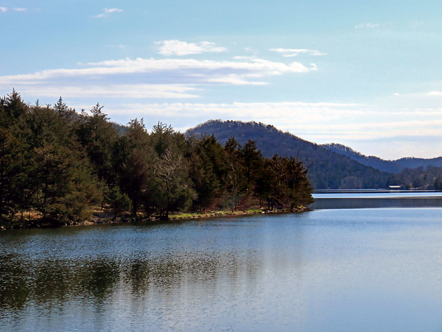
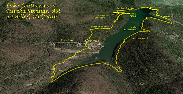
On Saint Patrick’s Day 2016, Wendy and I circumnavigated Lake Leatherwood near Eureka Springs, Arkansas on a 4.1 mile hike. Far less hilly than our trek a day earlier on the Dogwood Overlook Trail, this hike was a beautiful walk through the forest in one of the largest municipally owned parks in the nation.
Beautiful Lake Leatherwood (click image for slideshow)
Lake Leatherwood Hike
Leatherwood Park
Leatherwood City Park is 1620 acres and was developed in the late 1930s under the Soil Conservation Service and Works Progress Administration with labor from the Civilian Conservation Corps. A limestone-covered dam impounds the 80 acre lake, and the old cooking pavilion, diving platform, and bathhouse remain in service. What piqued my interest was that 25 miles of hiking and biking trails have been developed around the lake area, and the city has a nice online map detailing them.
Leaving the point, we diverted onto the Fuller Trail, which was much more to my liking. It led across a rocky streambed, where Wendy delighted in hunting for pretty rocks and crystals while I clambered upstream. I reached the Beacham Trail and turned back. When I rejoined Wendy, who was still busily sniffing out rock treasures, she made it clear we must return to this spot in the future. I happily agreed.
I enjoyed the quiet and isolation of the narrower stretch of the Beacham Trail on the east side of the lake, with plenty of lake views. We passed a peace symbol made of rocks, bringing to mind my childhood visits to Eureka Springs and the hippies that hung out there back in the 1970s. Today it is still a bohemian oasis in the Ozarks, welcoming alternate lifestyles.
Fording West Leatherwood Creek
Stranded bridge
The trail wound up and around three different entry creeks before reaching the floodplain of West Leatherwood Creek. The wide rocky creek bed was quite different from the forest trail we had been using. A wooden bridge stranded in the rocks tried to provide access. But the bridge we really needed had been swept away, so we got our boots and socks wet fording the creek. It was a shame the beavers had not felled some trees in a direction that would have helped us out.
We passed some cattails as our hike came to a close, with us walking past campsites and old rental cabins to return to our car. It had been a delightful hike. I look forward to returning here, both to let Wendy find more rock crystals and to hike the Miner’s Rock and Overlook trails on the hillside above the east side of the lake.
A Maelstrom at Crystal Bridges and The Open Road
Our brief stay in the Ozarks was drawing to a close. The next day we headed home, stopping over at the Crystal Bridges Museum of American Art in Bentonville, where we admired a whirling mass of painted aluminum by the walkway. Maelstrom by Alice Aycock reminds one of a tornado vortex, or flower blooms, or a shell.
Maelstrom by Alice Aycock
The temporary exhibit, which we enjoyed for free thanks to our dual memberships in Woolaroc and its membership in the North American Reciprocal Museum Association, was The Open Road, a photography exhibit on road trips. I liked the grumpy-looking woman in front of a colorful wall in an untitled piece by William Eggleston. Joel Sternfeld’s McLean, Virginia, December 1978 was a standout with its portrayal of a fireman picking out a pumpkin as a house burns in the background.
Wendy and I have been working most weekends since Spring Break on preparing for her move into Meador Manor with our marriage in July. So we passed on many weekends of good hiking weather, and I haven’t had time to blog about our hikes on Spring Break. Now that the city cleanup days are over and the Manor is almost ready, I can start catching up on my pending posts.
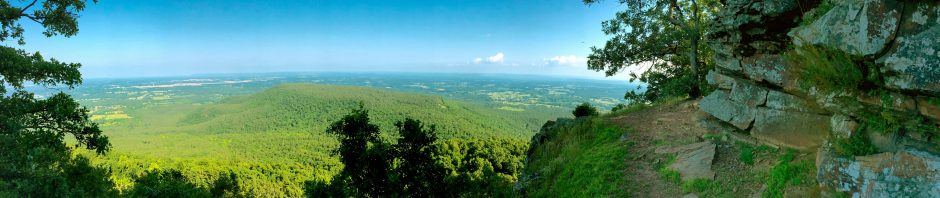
Wendy and I spent several days of our 2016 Spring Break at Sugar Ridge Resort on Beaver Lake in northwest Arkansas. We had previously stayed in the same cabin in June 2014 and March 2015. Previously we have hiked the short trail on the old railroad grade at Beaver town nine road miles northeast of our cabin and the Bench Rock Nature Trail four road miles southwest of our cabin. We again wanted to hike on this visit, and I selected a couple of nearby destinations that were unfamiliar to both of us. The first was only a couple of miles southeast of our cabin: the Dogwood Overlook Trail at Beaver Dam Site Park.
The Quest for Online Maps
I’ve created over 150 trail tracks since 2009
I had read online that the trail was two miles over steep terrain, although I wasn’t sure if that was an out-and-back distance, a loop, or one-way. I could not find an online trail map, although I read that local Boy Scouts had created a new hiking trail map available at the Corps of Engineers office in Rogers. Ideally every hiking trail would have a map online in PDF format along with GPX and KMZ GPS files. But that is easier said than done; I have not been posting my own maps in those formats either, instead only creating trail track views in Google Earth from KMZ files exported from my iPhone’s MotionX GPS app, which I edit in Corel Presentations and upload in the photo albums for my blog posts. I’ve created over 150 of those suckers thus far. Starting with this hike, I’m adding links to my Trail Track images and GPX and KMZ files to my Day Hikes spreadsheet. Eventually I would like to find the time to add similar links for previous hikes.
Trail Track (click image for slideshow)
Time to Hit the Trail
Beaver Dam
We took our time getting started, enjoying watching Downy and Red Bellied woodpeckers at our cabin feeder. Eventually we were ready to head out, and drove the couple of miles over to Beaver Dam. The trail entrance was in the overlook area, which was not yet open to vehicle traffic. So we parked uphill at a recreational vehicle dump station and trekked cross country to the overlook. As we gazed down at the spillway, the siren sounded, indicating the hydroelectric generator was starting up and there would be increased flow downstream into Table Rock Lake.
The trail led up along the ridge on the east side of the quarry, with the land sloping off to the east and abruptly ending in the quarry’s edge to the west. We ended up climbing 100 feet to reach highway 187, where the trail faded out after reaching a gate. Lacking a map, I thought we might have missed a turn. So we backtracked down to the quarry, finding no side trails. So we trooped back up the hillside to the highway and crossed it, happily discovering a trail badge and arrow on a tree on the far south side. They need to put up signage on the north side of the highway to help newbies to this trail.
The trail has a number of benches, for which we were grateful given its propensity for steep climbs and dives. Along the 150 foot ascent from the bluff back up to highway 187, I relaxed on a bench, snapping a photo of a nearby dogwood bloom. Meanwhile, Wendy the rock hound scoured the area for geological finds. She laughed when she found a rock that had been slathered with some of the green paint from the bench. A branch farther along the trail had been slathered too, but its paint was lichen.
We reached the highway, where this time there was a nice large “Hiking Trail” sign on each side of the road, making it easy to spot this crossing.
We enjoyed our hike, which gave us a good workout with its constant steep elevation changes. The steep hillsides made it seem longer than two miles, and admittedly our backtracking to the quarry stretched the hike to 2.6 miles. We also were both getting over colds, so we had hacked and coughed throughout our trek, blowing our noses regularly.
We weren’t hiked out yet; the next day we would have another great hike at Lake Leatherwood. More on that in the next post.
Cell phones are often a distraction in the classroom
Change is also quite evident in the impact of modern digital technology on our lives. The smart phone’s tremendous computing power, coupled to the mobility enabled by the cellular phone network, puts the world at our fingertips almost anywhere. But despite ingenious and powerful instructional uses, cell phones are still more of a distraction than an instructional tool at school. Their size and design promote content consumption, not content creation, and they are ill-suited for guided instruction. A larger screen and keyboard are vital to harnessing digital tools for instruction.
Meanwhile, I am dismayed to see my students lugging around bulging backpacks packed with huge textbooks in an era of e-readers and tablet computers. We should be providing our students with personal digital devices designed for school, but I recognize that our woefully underfunded schools could never afford to provide every student with an tablet or laptop computer, let alone support thousands of them. Or could they?
Even amidst our current school funding crisis, with its daily drumbeat of woe, there is hope for positive change. Inexpensive and very-low-maintenance Google Chromebooks could guarantee all students, even ours in Bartlesville, equal access to digital tools that are truly useful in almost every school subject. Our district is being forced to make the same deep cuts as others around our state, but we can still make things better for students and teachers using bond issue technology funds our patrons have already approved. It is illegal to use those funds for salaries, but we can certainly use them for student technology.
Chromebook
So next year we’ll be piloting Chromebooks in the 10-12 English courses at Bartlesville High School as a prelude to a multi-year rollout of a 1:1 computing initiative. Eventually each secondary student in our system will have his or her own Chromebook, taking the place of the traditional textbooks and putting a powerful content consumption and creation device in every student’s hands, all day long.
I’m going to be a part of that change, but not in the way you might expect. While next year I’ll be helping direct and support the Chromebook pilot project at our school, I won’t ever be using the new Chromebooks in my classroom, because after May 2017 I’ll no longer have a classroom. Change is gonna come…in fact, it is already here.
Curtailing my classes in 2016-2017
District newsfeed
Earlier this month budget cuts led to the district not filling the Community Relations Coordinator’s job when she resigned for a job closer to her home. That propelled me into a new job role of District Communications, distributing district news via the district website’s newsfeed and social media. I’ll continue in that role next school year.
The answer is that change is here in the form of a shrinking physics enrollment, the victim of continuing demographic changes. The decline may also reflect the success of the wonderful new STEM courses which I’ve facilitated but not taught. In 2016-2017 our district is going to change that downturn in physics enrollment into an opportunity to focus my physics teaching on three morning classes and free up my afternoons for the new initiatives and all of the other work I do outside the classroom.
So in August 2017 someone else will be teaching physics at Bartlesville High School, ending my 28 year tenure in that role. Fluffy won’t be in the classroom anymore – but she’s often missing anyway, thanks to treacherous catnappers!
2016-2017 will be my last year of teaching physics
Teaching in my old classroom back in 1991
Teaching electrostatics back in 1996
District rally back in 2000; pay has always been a problem for Oklahoma teachers
With Fluffy back in 2000
Having nerdy fun with students
With the Van de Graaff generators in 2013
I’ve had a good, long run teaching physics in this town. I will have taught over 2,600 students by the time I leave the classroom. When I graduated from college and was looking for a teaching position back in 1989, I turned down multiple job offers, holding out for a job teaching physics most, if not all, of the day. My dream came true when the job in Bartlesville opened up, where I could teach five classes of physics using the same curriculum I’d trained under at the University of Oklahoma.
Over the years my physics classes have fluctuated from 4 to 6 sections, with from 78 to 138 students in a given year. For several years our physics enrollment has not been enough to fill out a teaching day; the last year we actually had enough physics enrollment for five sections was 2011. I have avoided having to teach chemistry as a third science course by filling my time with many other duties, primarily the 20 years I have served as the chair of the science department for grades 6-12. But I’ve taken on many additional roles over the years.
The call to serve
Chuck McCauley
I have immense faith and trust in our new superintendent, Chuck McCauley, who I’ve had the pleasure of working with for 15 years in his various administrative positions. He has a vision for change and has asked me to help with two aspects of that vision. With his assurance that he is here for the long haul, I’ve decided to invest the remainder of my career in helping him make those changes happen.
I understand when parents, former students, and my colleagues tell me that my leaving the classroom to become an administrator is bittersweet for them. They know how I have served so long in so many ways, heeding the call to teach while working beyond my classroom to bolster our programs. I can assure them that the call to serve is still there, but now I need to heed a call to serve at another level.
Change is gonna come, because it has to
My work has kept me a very busy bachelor for over a quarter-century. But after this summer I will be 50 years old and married, and I recognize it is time for me to restructure and refocus my career. As I have contemplated my future with Wendy, the changes in our school over the past 27 years, and my retirement in 12-17 years, I realize that I cannot keep doing what I’m doing. I need to allow my professional life to evolve along with my personal one.
Even when I’m thinking back, I’m looking forward
When the end is coming, it is time for a new beginning. There are lots of reasons, admittedly both positive and negative, why I have agreed to leave the classroom after 28 years of teaching. But I am genuinely excited about the new opportunities to come. I know that I can make improvements in how our district communicates and how it uses technology. I know we need to change, and that change is gonna come for us whether we are ready or not. I want to help us to be ready for those changes and help make them happen. Change is gonna come, and I’m gonna be a part of it. The best is yet to come.

 This month I am turning 50 years old. At my age, a birthday requires relatively little planning. I’m content to share some time with my closest friends. When asked what I might like for a gift, I can honestly say their company would mean more to me than any other gifts they might bestow.