Junebug Day 8: Silver Thread Scenic Byway

June 21, 2012

Lake San Cristobal (click image for slideshow)

On Thursday, Day 8 of Operation Junebug, it was time for me to leave Gunnison and head south for a couple of days before returning home. The Hendersons had packed up at Taylor Park Reservoir and drove down to meet me at Gunnison, as they had never been to the Black Canyon of the Gunnison National Park and my vehicle pass was still valid. We had breakfast at the busy W Cafe downtown, which had been closed the previous two days for its annual cleaning. Then I drove us all west along US 50 to the national park.

Hendersons at Black Canyon

With the Hendersons at Black Canyon

This time we stopped at the visitor center at Gunnison Point, something I had omitted on my visit almost a week earlier. I peeked in at part of the video they were showing, but its pace was too slow for me and I’d already seen some photos and heard the story of some of the expeditions that first explored the canyon.

I snapped a photo of the Hendersons out on Gunnison Point and the river far below. We visited Pulpit Rock and The Chasm and the Painted Wall, where I caught a shot of it on this cloudless day, compared to the overcast late afternoon shot from my earlier visit.

We saw Sunset View and then hiked the Warner Nature Trail, passing a fallen tree with its exposed twisted trunk. It was a hot and tiring, albeit short, hike over to the view of the canyon at Warner Point. In the bright light the extrusions of rock were quite visible. Betty, who doesn’t like heights, posed as close to the edge as she would go.

The Hendersons were glad to have seen the Black Canyon, but it was time for them to drive to Salida and for me to make my way south to Pagosa Springs for the night. I drove us back to Gunnison and we parted, with them heading east on US 50 while I drove south on scenic highway 149.

Scenic Highway 149

Scenic Highway 149

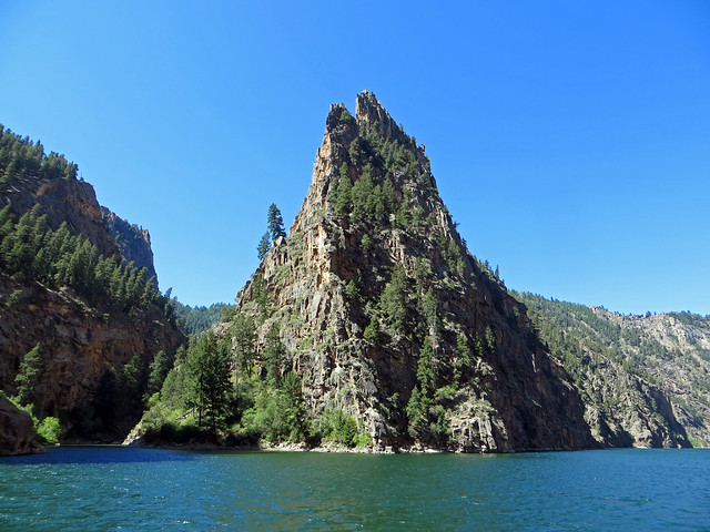
I’d passed the turnoff for this highway repeatedly over the past week without realizing I’d be taking it south through two mountain passes to reach US 160, which is my usual route through Wolf Creek Pass to drop way down into Pagosa Springs, where I vacationed in July 2010 and July 2011. The last 75 miles of the route, from Lake City to South Fork, is called the Silver Thread Scenic Byway because of the silver mining towns lining the route across the San Juan Mountains. The famous Million Dollar Highway, which I drove in 2011 as part of the San Juan Skyway, runs between Silverton and Durango to the west of this route. The views were less dramatic along 149, but the road had much less traffic and was far less terrifying!

Lake San Cristobal & the Slumgullion Earthflow

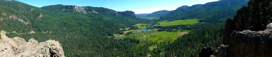
At first the mountains were distant backdrops. I drove through Lake City, population 375, which developed in the 1870s when gold was discovered near the Lake Fork of the Gunnison River. I pulled over south of town for the view looking south down the broad valley, with a subpeak of Red Mountain looming on the western slope.

There was an overlook of Lake San Cristobal, which formed 700 years ago when the first of a series of huge landslides, the Slumgullion Earthflow, dammed the Lake Fork of the Gunnison. The beauty here contrasts to the grisly tale of Alfred Packer, who dined upon some of his fellow prospectors when they became lost in the mountains somewhere around here in the winter of 1873-1874. A sketch appeared in Harper’s Weekly of the horrific remains which were discovered. The mountains here have unforgiving winters: John C. Frémont’s ill-fated fourth expedition had tried to pass through these mountains in 1848. He lost all 120 of his mules and 10 of the 35 men died, with some of the party also resorting to cannibalism to survive.

The road wound upwards past the current phase of the earthflow, with its own overlook. The crumbling earth was visible both above and beside the highway. The earth continues to slip about twenty feet per year on parts of the flow.

Slumgullion Earthflow

At the Windy Point Overlook the view of the San Juan peaks to the west was marred by the evening sun and heavy haze from a forest fire to the south, but there was another great vantage point of the Slumgullion Earthflow from there. I crossed the Slumgullion Pass at 11,530 feet.

Mount Baldy Cinco, Bristol Head, and the Rio Grande Pyramid

I drove past Mount Baldy Cinco which, as you might guess, has five summits with the tallest at 13,838 feet. Clouds made huge shadows across its slopes. I drove across Spring Creek Pass at 10,901 feet and then descended past Bristol Head, jutting up above the plain at 12,713 feet. I noticed a number of trailheads around this area, so that’s good news for future hiking trips.

Rio Grande Headwaters

The north face of the 13,821 foot Rio Grande Pyramid forms the headwaters of the Rio Grande, which flows 1,885 miles from here to the Gulf of Mexico, making it the third longest river in the United States of America. The haze above the forest from the fire to the southwest was becoming noticeable.

I pulled in at one trailhead to see a high mesa to the northeast which culminated in Bristol Head. Not much farther along was Stony Pass, used from 1871 and 1882 to reach the mining town of Silverton until the Durango-Silverton railroad line was completed.

Creede in the Golden Hour

I rounded the mountains and passed sunlit bluffs above the Rio Grande to arrive in Creede, the only incorporated town in Mineral county, home to 290 of the 712 people living in all of the county’s 878 square miles. 96% of the county, which is surrounded by the Rio Grande National Forest, is under the control of the federal government. Named after the discoverer of the Holy Moses mine, Creede produced much silver and copper, surviving the silver panic of 1893 by relying on the mining of lead and zinc. Its population declined by almost 25% in the past decade. There is a great mining loop north of town which I hope to walk some day.

Mine at Creede

The town is nestled at the foot of Mammoth Mountain, which rises over 2,000 feet above it. The clouds and setting sun gave a painterly look to the mountain ridge, and I shot a panorama during the golden hour.

All along this stretch the highway turnouts were blocked for some sort of event, but I was still able to capture golden hour snapshots of the cliffs at the base of Pool Table Mountain as the Silver Thread Scenic Byway came to an end at South Fork.

Beetles and Smoke

I remembered from last year how spruce beetles had been eating away at Wolf Creek Pass and was sad to see entire slopes of Engelmann spruces devastated by them as I descended to Pagosa Springs. I could also see heavy haze from the Little Sand fire hanging in the sky. The sun set as I drove to my hotel, and I could see the smoke hanging over the forest, reflecting off a pond in the pink twilight.

The south fire line is the Piedra River Trail I had hoped to enjoy again on this trip, so the next morning I would vacate Pagosa Springs, heading south to Ghost Ranch.

Click here for a slideshow from this day

Junebug Day 9: Ghost Ranch >

< Junebug Day 7: Aboard the Curecata 2

Posted in day hike, photos, travel | 2 Comments

Junebug Day 7: Aboard the Curecata 2

June 20, 2012

Gentle Readers: I am still catching up on my posts for Operation Junebug. This one goes up three days late, and there are three more still to come.

The Curecanti Needle (click image for slideshow)

A week into Operation Junebug I awoke and drove 16 miles west on US 50 to the Elk Creek Visitors Center of the Curecanti National Recreation Area. I arrived just after they opened and for $16 obtained a slot on the 10 o’clock boat tour on Morrow Point Reservoir. I’d wanted to do this since my hike down Curecanti Creek on Day 4 had not yielded a satisfactory view of the famed Curecanti Needle, the 700 foot high granite spire which graced the logo of the old Denver & Rio Grande Western Railroad. Aboard the boat I would get to see it in all of its glory, and I’d get a chance to walk the Pine Creek trail which I’d seen from high above on Highway 92.

Descent Along Pine Creek

Descent Along Pine Creek

I drove another 13 miles west to a gravel road leading down off US 50 to where Pine Creek feeds into what was once the Gunnison River and is now the shallow and narrow eastern end of Morrow Point Reservoir, just below the dam for Blue Mesa Reservoir.

I followed other riders down the 232 stairs leading into Black Canyon alongside Pine Creek to the railroad grade of the old Denver & Rio Grande, blasted out of the side of the canyon back in 1881 and 1882. The railroad tracks in this area were removed in 1949 and the only operating part of the railroad’s narrow gauge system are the Durango and Silverton Narrow Gauge Railroad, which I last rode in 2010, and the Cumbres & Toltec Scenic Railroad, which I rode in 2011. So on my third consecutive summer vacation in Colorado I was visiting the old rail line yet again, but this time I’d be walking and boating along part of its route, rather than riding in a steam train.

Along the Railbed to the Boat Dock

Along the Railbed

The canyon walls are always crumbling, and some huge stones had crashed onto the trail since it was constructed. You can see more rockfalls in the background of the picture. The ranger aboard the boat would later say that these piles are building up since the river no longer floods through here to sweep them away; one source says the building of the three dams has reduced the strength of the flooding Gunnison River by 80%.

It was a mile-long walk from the trailhead to the boat dock, at which were docked the 40-foot long Curecata 2 I’d be riding, along with some smaller launches. Two men were already aboard the large pontoon boat: Ranger Greg and Captain Steve.

Two More Great People in Our Park Service

Ranger Greg

Another couple and I were the first to arrive at the dock. Ranger Greg came out to greet us, a tall charming high school English teacher who lives nearby and has worked seasonally here and up at the isolated North Rim of the Black Canyon of the Gunnison National Park farther downstream. He showed off a photograph he’d taken the night before, combining several long exposures to get a twilight shot beneath one of the park bridges.

He did a great job of making everyone comfortable as he checked arrivals in and got us into our life jackets, repeatedly urging us to use the available restroom before boarding. I asked and he laughingly admitted that he’d seen someone sneaking a leak off the back of the boat before when in extremis. Altogether 40 people would be aboard the boat on this morning tour.

Captain Steve

Captain Steve was from Juneau, Alaska, where he spends the winter. (Interesting choice!) He was also quite friendly and accommodating, offering advice that if you really want to see Alaska, take the Alaska state ferries from town to town up the coast. Captain Steve, who was older than Greg, piloted the boat while Greg donned a microphone so he could tell us about the history, geology, and ecology of the area on our 45-minute cruise downstream. So in a way it reminded me of Gilligan’s Island, but this time around the skipper was thin and smart and Gilligan was actually The Professor. And instead of a three-hour tour, ours would be half that. Oh yeah, we didn’t get stranded on an island, either!

Sheared Wall

Heading Downstream

The lake is incredibly narrow at the boat dock, not all that much wider than the boat itself. That and the strong current coming from the dam makes piloting tricky, but Captain Steve made it look easy.

I could see the large veins of intruding rock in the canyon walls, and we passed sharp towering spires and rockfalls. I used my bionic vision to see one spire close up. There was one spot where the canyon wall was sheared off vertically.

Chipeta Falls

We passed Chipeta Falls, named after the wife of Ute chief Ouray. After the Meeker massacre in 1879, which Ouray’s group had not been involved in, Ouray helped negotiate the release of white captives by the Ute, with Chipeta helping searchers locate them. Nevertheless, Ouray’s group was forcibly relocated to Utah along with the other Utes and he died soon after. Chipeta lived on until 1924, a proponent of peace known late in life for spending her money on orphan children. She was buried in the appropriately named Bitter Creek in Utah but subsequently reinterred with her husband at their farm in Montrose.

Chipeta Falls

The Curecanti Needle

At last Ranger Greg held up the logo of the Denver & Rio Grande, explaining that we were approaching the Curecanti Needle. I snapped a photo of it looking downstream.

The Curecanti Needle

Later I shot it looking upstream, the vantage point the original lithograph was made from. This was also where Curecanti Creek empties into the lake, the spot where I had stood on the shore at the end of the Curecanti Creek Trail a few days earlier.

Cliff Projection

Turnaround

We passed an enormous rockfall, which had left a fin of rock projecting from the canyon wall. Some canyon walls showed many layers of eroding rock.

When the lake suddenly widened, we had reached the far end of our journey. I took a final look downstream and then the Curecata 2 turned about and headed back upstream.

More projections stuck out from the side of the canyon. As the reservoir’s bottom lifted beneath us, occasional metal bars became visible from the side of the canyon. Ranger Greg explained those were the remains of the old telegraph line which ran above the railroad bed. One was stuck into a rock which protruded from the lake.

Captain Steve had to be careful through here what with the ever-shallower lake bed and the occasional driftwood. Finally the old railroad bed began to emerge from the waters of the lake – the end of the Pine Creek Trail. I got a good shot of one of the old telegraph poles sticking out of the canyon wall.

The Railbed Disappears

I Walk the Line

We disembarked, thanking the Park Service men, and while the rest of the group headed back toward the trailhead, I was the only one who chose to head downstream along the remains of the railroad bed. I wanted to hike all of the Pine Creek Trail, plus I wanted to avoid being stuck on those interminable stairs behind a large group of elderly couples and families with children.

I was rewarded with a close-up look at the interesting rock along the canyon wall. It was 0.55 miles from the boat dock to the end where the railroad bed sank beneath the water. I followed the example of a bird and posed out on a rock, and walked past a very dark section of wall where erosion exposed lighter rocks.

On my return trip I passed the boat dock, where Ranger Greg was prepping the next boat load of tourists. The lake narrowed and the current increased to where you would swear this was just a river. I reached Pine Creek, where the railroad bed disappeared again and the many stairs beckoned.

Pine Creek Stairs

Climbing Up

The stairs are a combination of stone and wood sections, sometimes dodging trees which provided valuable shade during the ascent next to burbling Pine Creek. I had walked a total of three miles going down to the boat, from the boat to the end of the line, and back up to the trailhead, while the boat had made an 11-mile round-trip on Morrow Point Reservoir.

Video Aboard the Curecata 2

Superb Mexican Food at Añejo Bistro & Bar

Añejo Bistro & Bar

I drove back to Gunnison for lunch, thankfully heeding TripAdvisor’s advice to eat at Añejo Bistro & Bar. It is a narrow and deep little bar/restaurant tucked in along the west side of Main south of US 50. The online advice said there were a few tables in the back and indeed the waitress offered to let me sit at the bar up front or walk past the kitchen unit to the tables at the rear. I ordered my usual, steak fajitas, unaware that I was about to have some of the best Mexican food of my life.

The cook prepared fresh salsa for me. I grew up eating cooked salsa at El Chico and it remains my preference, but this fresh salsa was amazing. It had just the right mix of ingredients, flavor, and spiciness. Oh, this boded well!

My steak fajitas were an excellent cut of meat. The biggest downfall of Bartlesville’s Mexican restaurants is the poor to mediocre quality of their meat. El Chico has much better meat, but even it pales in comparison to what is served at El Plazuela at Santa Fe’s famous La Fonda Hotel and, now I know, what they serve at Añejo’s in Gunnison. Even better, it was served with superbly cooked onions and peppers and portabello mushrooms. The rice was fluffy and flavorful, and so on. There is now a three-way tie for the best fajitas ever: La Rosa in Bend, Oregon; La Plazuela in Santa Fe, New Mexico; and Añejo’s in Gunnison, Colorado. And Anejo’s had the best salsa and was the cheapest. The Hendersons called a bit later and I told them I’d already had lunch but they should try Anejo’s. They did and reported it was indeed superb. Bravo!

It was a delightful end to my adventures for the day. I spent the remainder of the day editing photos and blogging. This trip has been so packed with adventures that I was often three days behind on posts. The next day I would rise for breakfast with the Hendersons and a return to the Black Canyon of the Gunnison, then take a scenic drive south to Pagosa Springs.

Click here for a slideshow from this adventure

Junebug Day 8: The Silver Thread Scenic Byway >

< Junebug Day 6: Three Lakes

Posted in day hike, photos, travel, video | 2 Comments

Junebug Day 6: Three Lakes

June 19, 2012

Lost Lake Slough (click image for slideshow)

Having done moderately well above 10,000 feet for part of the previous day, I agreed to meet my friends the Hendersons for lunch at Crested Butte on Day 6 of Operation Junebug. I worked on my blog posts in the morning until about 11 a.m. and then drove up to Crested Butte.

Crested Butte

Downtown Crested Butte

That big lump reaches 12,160 feet at its pinnacle but thankfully the main town of about 1,500 permanent residents is only 8,900 feet above sea level. I parked downtown, with the mountain looming to the east, and walked the main drag of Elk Avenue. I was surprised by a banner proclaiming “Urinetown” at the old city hall. Urinetown is a musical comedy, it turns out.

There were scads of restaurants and a few hippie stores, but thankfully no truly tacky tourist shops. I liked the Old Rock Community Library building’s exterior, built as a school back in 1883.

Upper Loop Trail

The Hendersons called and I had a bit of time left before they arrived from Taylor Park Reservoir, so I drove up to Mount Crested Butte and took Hunter Hill road to an overlook which serves as the trailhead for the Upper Loop trail, which winds along the mountainside through aspen groves down to a subdivision.

The southwestward panorama from the overlook was sweeping. From left to right in the panorama are Crested Butte, Red Mountain, Whetstone Mountain, and Mount Emmons. The last one is the place of continuing controversy over attempted development of a molybdenum mine, thus far fought off by Crested Butte.

Overlook Panorama

Below me I could see the little ski town and ahead and left of the trail was the mountain itself. The trail made a steep but short ascent as it headed southeast and then descended into the aspens, with occasional wildflowers. A Tiger Swallowtail butterfly alighted and I was enjoying the aspens when the Hendersons called and I had to return to town for lunch. We had a tasty pizza at the Brick Oven and Betty and John posed on a cute bench out front. Then John drove us west about 19 miles to the Lost Lake Slough.

Lost Lake

Three Lakes Trail

John had camped with a buddy here over 20 years ago when they were elk hunting, and wanted to hike up to the waterfall at Lost Lake. We set forth on Trail #843, the Three Lakes Trail, climbing through groves of tall trees and aspens.

We soon arrived at Lost Lake with East Beckwith Mountain rising beyond. There was a significant logjam near the trail. John led us around the lake and we bushwhacked through a meadow with a few wildflowers. We rejoined the trail and made our way to the waterfalls.

Lost Lake Waterfalls

The falls was a cascade tumbling through a slot in the slope. I shot a video, of course.

Dollar Lake

Dollar Lake

Next we headed over to the third lake, Dollar. Along the way another Tiger Swallowtail was enjoying a field of wildflowers. The Anthracite Range to the southeast still sported a bit of snow. The nearest slope of East Beckwith looked like it would be a dreadful climb, being a huge rubble field.

There were mountain bluebells and we had ascended to about 10,000 feet and could now see Lost Lake Slough below us with Marcellina Mountain as a backdrop, inviting a panorama shot.

We reached the short spur leading to Dollar Lake, which was close to the East Beckwith peaks. The Hendersons and I again traded taking shots. Some of the nearby peaks were quite sharp and jagged.

Descent

We were all feeling the effects of the altitude on our stamina and glad to head downhill back to Lost Lake Slough. We again saw shifts from pines to aspens and back again, with the aspens rustling in the wind as we walked. When Lost Lake Slough was in sight, we could see a couple out in an inflatable boat. They floated out across the lake as we descended.

Lost Lake Slough

A large beaver lodge was also visible on the lake. There were more wildflowers along the path such as scarlet trumpet phlox. The view of the slough was quite beautiful in the late afternoon sun. The peaks resembled a snowy saddle. I closed out my photography for the day with a panorama.

Hobbling Home

We returned to Crested Butte to eat dinner at the Wooden Nickel, worn out from a mere three mile hike. But we had been hiking at elevations between 9,600 and 10,000 feet. As we left the restaurant, Betty commented on how John and I were walking. I said we were swaggerin’, but John admitted we were really hobblin’.

We parted ways, with plans to join up again in two days. The Hendersons have never been to the Black Canyon of the Gunnison National Park and my pass was good for a week, so I would be taking them over there. But before that there was a boat ride I wanted to take…

Click here for a slideshow from this day hike

Junebug Day 7: Aboard the Curecata 2 >

< Junebug Day 5: River and Mountains

Posted in day hike, photos, travel, video | 3 Comments

Junebug Day 5: River and Mountains

June 18, 2012

After spending two days hiking in the Gunnison area I hoped I’d acclimated better to the altitude and could venture higher during the day, while sleeping below 8,000 feet in Gunnison. So I made plans to drive up after lunch to Taylor Park Reservoir at 9,400 feet and see friends who spend a week or so there each summer for the fishing and to get away from it all.

Up in the mountains (click image for slideshow)

The Gunnison River

Gunnison Whitewater Park

I worked on the blog in the morning until the maid reached my room, departing to go walk by the Gunnison River. My first stop was Gunnison Whitewater Park, just west of town. I’d seen the sign when driving to Hartman Rocks and wondered what was there. I found a parking lot beside the river, where rock has been placed to create various water dynamics for folks to practice with their kayaks and the like.

No one was out on the water, at least not in sight, so I drove a few miles farther west on US 50 to the Neversink Area of the Curecanti National Recreation Area, where there is a riverside trail. I followed it along the river for half a mile until it was lunchtime, so I walked about 3/4 of the entire trail.

Gilded Flicker Woodpecker

This is known as a good birding trail, so a Gilded Flicker Woodpecker obligingly hopped onto the trail with me and then posed on a fencepost. I followed the shady trail alongside a side channel of the Gunnison River, with numerous paths down to the water used by anglers.

But then the vegetation began to close in and the insects were becoming a tad annoying, so when my alarm sounded for me to turn back, I was not displeased. I drove back to Gunnison for a so-so French Dip sandwich and then headed north on the Crested Butte highway to Almont, turning off there to follow county road 742 alongside the Taylor River up toward Taylor Park Reservoir.

Taylor Park Reservoir

Back in the mid 1930s a 206 foot high earthfill dam with a crest 675 feet long was built up here at an elevation of 9,330 feet 30 miles northeast of Gunnison on the western flank of the Sawatch Mountains. A reclamation project, it stores water much like Blue Mesa Lake so it can be used for irrigation down below. People fish for rainbow, brown, and Loch Leven trout in the lake, a primary draw for my teaching colleague, Betty Henderson, and her husband, John.

Taylor Park Reservoir

They rent a cabin at the Taylor Park Trading Post and go out on the lake to fish each morning. I was to arrive after lunch, but my arrival was delayed by heavy road construction on county road 742. Eight miles of the asphalt were being ripped out and the road widened. I had to wait 20 minutes for a pilot truck to guide me and a short line of vehicles through a couple of miles of active work. So I arrived at Taylor Park 30 minutes late, but then the Hendersons and I piled into John’s truck to see the area sights.

Tin Cup

The first stop was the tiny town of Tin Cup, a forming mining town with some very old buildings scattered about the town site, several presumably maintained to resemble what they looked like originally. I was feeling the effects of altitude a bit and did not have John pull over so I could take photos here, but there are plenty on the web. The town’s entry sign is memorable for its admonition: “This is God’s country. Please don’t drive through it like hell.”

The Hendersons pointed out a cabin dating back to the 1800s and old abandoned fire hydrants from a defunct water system. The town’s name comes from a prospector who panned gold in Willow Creek in 1859 and carried it back to camp in a tin cup. The town exploded twenty years later when lode deposits were found, reaching almost 1,500 residents. It would have been named Virginia City but confusion with similar town names in other states led it to be renamed Tin Cup in 1882. It was a very violent place in those days, with two marshalls shot to death in 1882 and 1883. The mines were exhausted by the World War I era and the town dwindled away.

Tin Cup Cemetery

Tin Cup Cemetery

The Hendersons took me to the oddball Tin Cup cemetery, or “cemetary” as its signs proclaim. It consists of several knolls rising up out of huge beaver ponds. Each knoll is reserved for different types of folks: Jewish, Catholic, Protestant, or other. The other is Boot Hill for outlaws and atheists, but isolated back in a separate area a Negro cook is buried. The bridge across the pond to Boot Hill was out, so we missed that area.

Many graves are protected by split-rail fences, and I spotted one very fancy tombstone. Other graves have only wooden markers, and some are merely piles of stones. I liked one stone marker which had a verse for the wife but nothing yet for her surviving husband. I suppose they’ll wait to decide what to say about him!

Mirror Lake

Mirror Lake

John drove us over to Mirror Lake, a small but pretty lake nestled against the western flanks of Mount Kreutzer and Emma Burr Mountain. The wind was up, so the mirror was rippling and not providing images. There were several long waterways running down the steep slope of Mount Kreutzer and a bit of snow up top.

The Hendersons and I took turns posing at this stop. Yes, that’s John, not a younger Wilford Brimley. 🙂

Panning for Gold

Betty and John both have fun panning for gold on their trips. John was anxious to bushwhack up one of the feeder streams for East Willow Creek and try to find some bedrock and pan for gold. So we stopped there, the location where Betty took a favorite photo of hers on a previous trip. While John forged uphill searching for bedrock, Betty and I tarried, taking pictures and feeling the effects of the 10,700 foot elevation.

Panning for Gold

I shot my own photo of the beautiful stream, which is a slash of beauty through the forest. Then I composed a photo of Betty beside the stream and then she took her turn, although I’m a terrible subject. I prefer to be behind the lens, not in front of it!

John returned from his trek upstream, reporting no finds in the pans he had made. He and Betty conducted another pan while I observed the process. Although it did not yield anything, I enjoyed watching them at one of their hobbies. I wrapped up with another couple of shots of the tributary.

Dinner and Plans

We headed back to Taylor Park Reservoir for dinner. Betty cooked some beans while John grilled some delicious hamburgers – using a gas-fired grill to comply with the statewide fire ban. After the delicious dinner I had to excuse myself to drive back down to Gunnison. I could feel a headache building from the high altitude. Happily it was quite mild, especially compared to what I’d endured a couple of days earlier, and disappeared soon after I returned to my hotel below 8,000 feet.

Given my progress in handling the altitude, the Hendersons and I had made plans to meet in Crested Butte for lunch the following day and have John lead us on a hike at Lost Lake. I’d finally get in a hike in the high country!

Click here for a slideshow from this part of the trip

Junebug Day 6: Three Lakes >

< Junebug Day 4: Pinnacles and Needles

Posted in day hike, photos, travel | Leave a comment

Junebug Day 4: Pinnacles and Needles

July 17, 2012

Gentle readers, I’m keeping very busy on this summer vacation, so I’m now running about three days behind on the posts…bear with me, I will get everything posted as quickly as I can. 🙂

On my third night of Operation Junebug I slept much better down at Gunnison, so the lower elevation prevented a recurrence of altitude sickness. After breakfast I drove west along the Gunnison River and Blue Mesa Lake to hike at the Curecanti National Recreation Area. The Dillon Pinnacles, breccia intrusions exposed by erosion, had caught my eye two days before and there was a hiking trail to them.

Dillon Pinnacles

Dillon Pinnacles (click image for slideshow)

I drove 23 miles over to the trailhead, where a young lady park ranger was also heading out on the trail ahead of me. I poked along, seeing her diminishing figure ahead on the trail from time to time. I was rounding a big hill and then the pinnacles came into sight.

A sign explained how 30 some million years ago volcanic explosions yielded accumulating lava, mud flows, and rocks to form the breccia forming today’s pinnacles. Two million years ago the Gunnison River began carving away at the breccia, leaving behind what we see today.

The trail led upwards alongside a dry tree-lined channel. The day was warming quickly and I paused to sip water and zip off the lower part of the legs of my hiking pants, converting them into shorts.

I was close enough to the pinnacles to see large stones projecting from the breccia and a couple on the trail ahead of me provided some scale. The trail continued to climb and as it levelled out below the pinnacles I saw a sign and that the park ranger had stopped to chat with the couple on the trail.

The Ranger

Friendly Ranger

I walked up and the couple headed onward while the park ranger turned and greeted me. We talked for over 30 minutes, with me asking her trail recommendations and her pointing out a few things about this trail. This friendly and clearly intelligent young adult brought out my past experience as a college advisor, prompting me to ask about her background and future plans. I found out she has a degree in geology and loves physics, conducting astronomy hikes at her different postings. She’s considering some day settling down and perhaps teaching high school earth science and physics, which of course led me to proffer advice and encouragement. It was a wonderful encounter and it is great to see such fine people working in our national parks, out helping folks and making us feel welcome.

I also learned from the ranger that this reservoir was topped out a few months back but had already been drawn down about 38 feet and she expected they would take it down to 55 feet below its full level. She explained that the primary purpose of Blue Mesa is to store up water so that the water level in Morrow Point and Crystal farther down the Black Canyon could be held up and for their big release of water from Crystal to recreate flood flows. The farmers are already making water demands in the unseasonably warm late spring weather.

Little Pinnacle

Pinnacles

Finally we parted and I headed along the trail, which does not try to make the steep ascent up to the pinnacles but runs parallel to the lake below them. I was now close enough to see their texture better, especially using my superzoom camera. I had a sweeping view of this portion of the lake, including the dam which I would be crossing later in the day.

One part of the formation had clearly different rock at the top, something the park ranger could have told me all about. A small pinnacle beside the trail allowed for a close-up inspection of the breccia and the lichen growing on it as well. I posed with the little guy and walked to a loop at the end of the trail, overlooking the lake and providing a view of more yellowish rock layers.

Windy

Windy

The wind suddenly picked up from a nice breeze to strong gusts, covering the lake in whitecaps and sending boats scurrying. I scurried too, ready to get off the windswept overlook. I took in another last view of some of the pinnacles along the way and was not surprised to find the ranger had left her lonely and windy vigil at the earlier overlook. She’d mentioned she would probably go work another trail down in the canyon. But the trail she’d mentioned that perked my interest most was a different one leading down into a side creek, so I would not be seeing her again.

I passed a young couple who had ventured down to a big driftwood tree by the whitecapped reservoir, and walked by the small mesa adjacent to the pinnacles while watching a sailboat motoring upstream. Reaching the trailhead, I hopped in my car and drove across the dam along highway 92, which hugs the north rim of this stretch of the Black Canyon of the Gunnison, upstream from the national park.

Curecanti Creek Overlooks

Pioneer Point

Curecanti Creek, which is named after a Ute Indian chief, tumbles southward at Pioneer Point down into what was the Gunnison River and is now Morrow Point Reservoir in the upper section of the Black Canyon. Highway 92 has multiple overlooks at Pioneer Point, where Blue Creek also feeds into the reservoir from the south.

The narrowness and depth of both the side creeks and the main river channel are impressive, with the reservoir looking like a small green pool down below. It was a bit intimidating to think how I’d be descending 880 feet to reach the reservoir, part of the descent following Curecanti Creek. It was even more intimidating to know I’d have to haul myself back up!

The various canyon views were impressive, and from this overlook one could see another overlook nearby, which was perched on an enormous slab of swirly-colored stone. Later I found the overlook I was on was perched right on the edge of a big near-vertical slab. I used my camera’s superzoom to peer down at Curecanti Creek and the series of waterfalls I would be walking next to. This looked challenging and rewarding.

Upper Bridge

Descent to the Creek

I headed off along the trail, which at first led north along the rim high above the eastern side of the creek. There was a nice view south along the creek’s canyon as the trail began a few switchbacks in its descent down the eastern side of the canyon, with a jutting needle beside the trail. There were only a few steps along the way.

I reached the bottom of the eastern side of the trail and could now see the creek below me as the trail headed to a bridge crossing, providing a nice view of the creek. There were huge chunky rocks beside the trail and across the creek. I could look across at the eastern wall of the canyon, and one huge rock which had broken off and tumbled onto the trail showed signs of its turbulent formation.

Descending Beside the Creek

A tree growing across the trail and then up provided a unique seat for me while a butterfly alighted on a nearby pine tree and then shifted to another perch. The trail edged away from the western side of the canyon in a wider spot, where I was startled to see a picnic table, since this clearing was still high above the reservoir yet hundreds of feet below the rim. The table provided a nice view of the western canyon wall and here it contrasted sharply to the eastern wall’s appearance.

The trail ran through trees and alongside huge rockfalls on the western slope. Cool air blew out of holes and cracks in these rockfalls, providing some natural air conditioning. There are some deep crevices back there.

Waterfalls

Now began a long series of waterfalls, cascading down boulders and ledges as the trail descended quite steeply. Somewhere along here something had died and the smell was quite atrocious. Later I found rotting fish remains beside one of the falls, so perhaps these were leftovers from a bear’s snack or the merciless waterfalls simply pounded them to death.

The view opened up and I could see a large spire on the eastern wall with a big bite taken out of it near the top. Later I found the enormous chunk of rock which had broken free. What an impact that must have been!

The view downstream was still gorgeous, with another bridge ahead, and the eastern wall was becoming much steeper. I crossed the second bridge, shifting me to the eastern side of the creek. There were more waterfalls below that, and a tree competing with the canyon walls.

Morrow Point Reservoir

As I approached the end of the trail, the eastern wall became truly intimidating and Morrow Point Reservoir became visible. The creek was tumbling over a broader array of rocks as it approached the lake. A large slab marked where the creek leveled out.

A vault toilet was situated here near the end of the trail, clearly brought in by boat. The trail finally ended at the lake shore. I turned around to look up the creek. The reservoir was quite narrow here, deep below the canyon walls.

I took the last bit of trail I could find for a promised view of the 700 foot high granite spire called the Curecanti Needle, which graced the logo of the old Denver and Rio Grande Railroad, a remnant of which is the Durango-Silverton line I’ve ridden twice before. If that was the needle before me, it sure looked different from this angle, so I probably missed something. Most shots I’ve seen of it are taken from a boat. Regardless, it had been a splendid and gorgeous hike down to here.

Morrow Point Reservoir

Ascent

On the way back up I walked out on boulders to shoot the falls below the lower bridge from a different angle and then posed on that bridge. Farther up I again walked out on boulders to shoot one of the higher waterfalls. A Pearl Crescent butterfly posed for me as I ascended to the upper bridge and made my way back up to the rim overlooks.

Waterfalls are best appreciated in video, so here’s my collection of such clips from the Curecanti Creek Trail.

Above Morrow Point Reservoir

Pioneer Point

From the overlooks I took a shot of the view upstream and a bird of prey flying across the canyon. I found a nice spot for a shot and offered to exchange shots with a couple who were at the overlook with me. They have been coming up to Blue Mesa for years but until today had never crossed the dam over to this side of the canyon. I told them about the trail and the picnic table, etc. and they were very interested, planning to make the hike for a picnic lunch sometime.

Pine Creek Trail and Blue Mesa Dam

I drove back along Highway 92, stopping to shoot the view westward along the canyon. Farther along the road I could see the old Denver and Rio Grande narrow gauge railway path leading along the canyon wall. That portion is now the Pine Creek Trail, leading over to a boat landing on the lake for a park service boat tour I shall take someday to get a good look at the Curecanti Needle.

I pulled over for the view of the Blue Mesa Dam, an earthen dam now covered with riprap which rises 390 feet and is 785 feet long at the crest. The outflow spins two great turbines, each of which can put out 30 megawatts of electrical power. Below was the Pine Creek trailhead, with 232 steps descending from the canyonside down to the old railway grade.

The Curecanti Creek Trail was quite delightful with its magnificent canyon walls and waterfalls. The next day I’d be braving a return to the high country, heading up to the cabin rented by the Hendersons up at Taylor Lake Reservoir so they could show me around their favorite vacation spot.

Click here for a slideshow from this day hike

Junebug Day 5: River and Mountains >

< Junebug Day 3: Hartman Rocks

Posted in day hike, photos, travel, video | Leave a comment