
June 20, 2012
Gentle Readers: I am still catching up on my posts for Operation Junebug. This one goes up three days late, and there are three more still to come.

The Curecanti Needle (click image for slideshow)
A week into Operation Junebug I awoke and drove 16 miles west on US 50 to the Elk Creek Visitors Center of the Curecanti National Recreation Area. I arrived just after they opened and for $16 obtained a slot on the 10 o’clock boat tour on Morrow Point Reservoir. I’d wanted to do this since my hike down Curecanti Creek on Day 4 had not yielded a satisfactory view of the famed Curecanti Needle, the 700 foot high granite spire which graced the logo of the old Denver & Rio Grande Western Railroad. Aboard the boat I would get to see it in all of its glory, and I’d get a chance to walk the Pine Creek trail which I’d seen from high above on Highway 92.

Descent Along Pine Creek
Descent Along Pine Creek
I drove another 13 miles west to a gravel road leading down off US 50 to where Pine Creek feeds into what was once the Gunnison River and is now the shallow and narrow eastern end of Morrow Point Reservoir, just below the dam for Blue Mesa Reservoir.
I followed other riders down the 232 stairs leading into Black Canyon alongside Pine Creek to the railroad grade of the old Denver & Rio Grande, blasted out of the side of the canyon back in 1881 and 1882. The railroad tracks in this area were removed in 1949 and the only operating part of the railroad’s narrow gauge system are the Durango and Silverton Narrow Gauge Railroad, which I last rode in 2010, and the Cumbres & Toltec Scenic Railroad, which I rode in 2011. So on my third consecutive summer vacation in Colorado I was visiting the old rail line yet again, but this time I’d be walking and boating along part of its route, rather than riding in a steam train.
Along the Railbed to the Boat Dock

Along the Railbed
The canyon walls are always crumbling, and some huge stones had crashed onto the trail since it was constructed. You can see more rockfalls in the background of the picture. The ranger aboard the boat would later say that these piles are building up since the river no longer floods through here to sweep them away; one source says the building of the three dams has reduced the strength of the flooding Gunnison River by 80%.
It was a mile-long walk from the trailhead to the boat dock, at which were docked the 40-foot long Curecata 2 I’d be riding, along with some smaller launches. Two men were already aboard the large pontoon boat: Ranger Greg and Captain Steve.
Two More Great People in Our Park Service

Ranger Greg
Another couple and I were the first to arrive at the dock. Ranger Greg came out to greet us, a tall charming high school English teacher who lives nearby and has worked seasonally here and up at the isolated North Rim of the Black Canyon of the Gunnison National Park farther downstream. He showed off a photograph he’d taken the night before, combining several long exposures to get a twilight shot beneath one of the park bridges.
He did a great job of making everyone comfortable as he checked arrivals in and got us into our life jackets, repeatedly urging us to use the available restroom before boarding. I asked and he laughingly admitted that he’d seen someone sneaking a leak off the back of the boat before when in extremis. Altogether 40 people would be aboard the boat on this morning tour.

Captain Steve
Captain Steve was from Juneau, Alaska, where he spends the winter. (Interesting choice!) He was also quite friendly and accommodating, offering advice that if you really want to see Alaska, take the Alaska state ferries from town to town up the coast. Captain Steve, who was older than Greg, piloted the boat while Greg donned a microphone so he could tell us about the history, geology, and ecology of the area on our 45-minute cruise downstream. So in a way it reminded me of Gilligan’s Island, but this time around the skipper was thin and smart and Gilligan was actually The Professor. And instead of a three-hour tour, ours would be half that. Oh yeah, we didn’t get stranded on an island, either!

Sheared Wall
Heading Downstream
The lake is incredibly narrow at the boat dock, not all that much wider than the boat itself. That and the strong current coming from the dam makes piloting tricky, but Captain Steve made it look easy.
I could see the large veins of intruding rock in the canyon walls, and we passed sharp towering spires and rockfalls. I used my bionic vision to see one spire close up. There was one spot where the canyon wall was sheared off vertically.
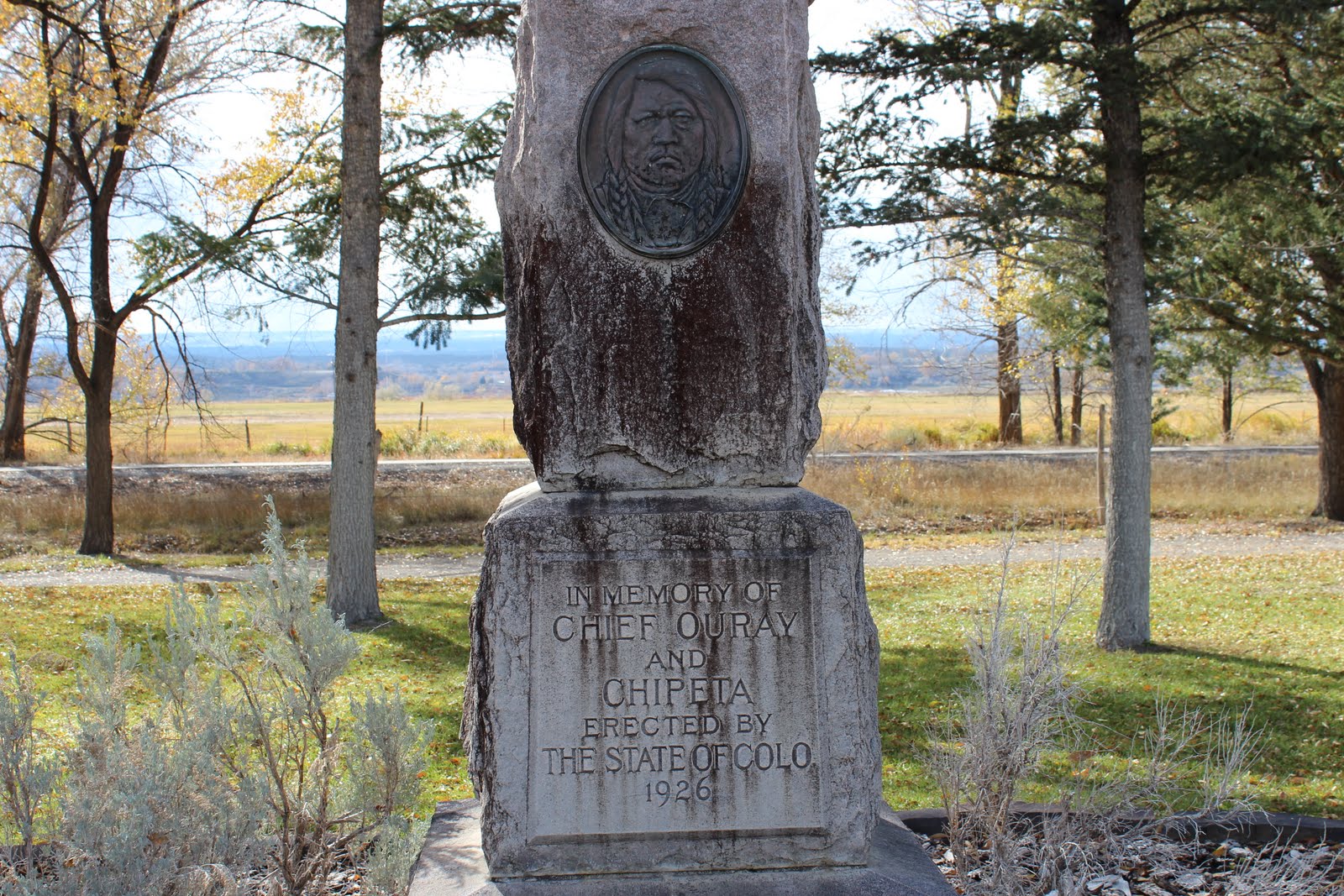
Chipeta Falls
We passed Chipeta Falls, named after the wife of Ute chief Ouray. After the Meeker massacre in 1879, which Ouray’s group had not been involved in, Ouray helped negotiate the release of white captives by the Ute, with Chipeta helping searchers locate them. Nevertheless, Ouray’s group was forcibly relocated to Utah along with the other Utes and he died soon after. Chipeta lived on until 1924, a proponent of peace known late in life for spending her money on orphan children. She was buried in the appropriately named Bitter Creek in Utah but subsequently reinterred with her husband at their farm in Montrose.

Chipeta Falls
The Curecanti Needle
At last Ranger Greg held up the logo of the Denver & Rio Grande, explaining that we were approaching the Curecanti Needle. I snapped a photo of it looking downstream.
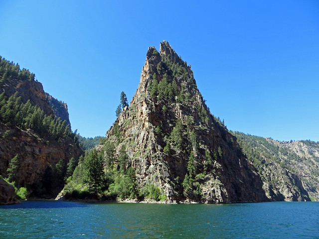
The Curecanti Needle
Later I shot it looking upstream, the vantage point the original lithograph was made from. This was also where Curecanti Creek empties into the lake, the spot where I had stood on the shore at the end of the Curecanti Creek Trail a few days earlier.

Cliff Projection
Turnaround
We passed an enormous rockfall, which had left a fin of rock projecting from the canyon wall. Some canyon walls showed many layers of eroding rock.
When the lake suddenly widened, we had reached the far end of our journey. I took a final look downstream and then the Curecata 2 turned about and headed back upstream.
More projections stuck out from the side of the canyon. As the reservoir’s bottom lifted beneath us, occasional metal bars became visible from the side of the canyon. Ranger Greg explained those were the remains of the old telegraph line which ran above the railroad bed. One was stuck into a rock which protruded from the lake.
Captain Steve had to be careful through here what with the ever-shallower lake bed and the occasional driftwood. Finally the old railroad bed began to emerge from the waters of the lake – the end of the Pine Creek Trail. I got a good shot of one of the old telegraph poles sticking out of the canyon wall.

The Railbed Disappears
I Walk the Line
We disembarked, thanking the Park Service men, and while the rest of the group headed back toward the trailhead, I was the only one who chose to head downstream along the remains of the railroad bed. I wanted to hike all of the Pine Creek Trail, plus I wanted to avoid being stuck on those interminable stairs behind a large group of elderly couples and families with children.
I was rewarded with a close-up look at the interesting rock along the canyon wall. It was 0.55 miles from the boat dock to the end where the railroad bed sank beneath the water. I followed the example of a bird and posed out on a rock, and walked past a very dark section of wall where erosion exposed lighter rocks.
On my return trip I passed the boat dock, where Ranger Greg was prepping the next boat load of tourists. The lake narrowed and the current increased to where you would swear this was just a river. I reached Pine Creek, where the railroad bed disappeared again and the many stairs beckoned.

Pine Creek Stairs
Climbing Up
The stairs are a combination of stone and wood sections, sometimes dodging trees which provided valuable shade during the ascent next to burbling Pine Creek. I had walked a total of three miles going down to the boat, from the boat to the end of the line, and back up to the trailhead, while the boat had made an 11-mile round-trip on Morrow Point Reservoir.

Superb Mexican Food at Añejo Bistro & Bar
Añejo Bistro & Bar
I drove back to Gunnison for lunch, thankfully heeding TripAdvisor’s advice to eat at Añejo Bistro & Bar. It is a narrow and deep little bar/restaurant tucked in along the west side of Main south of US 50. The online advice said there were a few tables in the back and indeed the waitress offered to let me sit at the bar up front or walk past the kitchen unit to the tables at the rear. I ordered my usual, steak fajitas, unaware that I was about to have some of the best Mexican food of my life.
The cook prepared fresh salsa for me. I grew up eating cooked salsa at El Chico and it remains my preference, but this fresh salsa was amazing. It had just the right mix of ingredients, flavor, and spiciness. Oh, this boded well!
My steak fajitas were an excellent cut of meat. The biggest downfall of Bartlesville’s Mexican restaurants is the poor to mediocre quality of their meat. El Chico has much better meat, but even it pales in comparison to what is served at El Plazuela at Santa Fe’s famous La Fonda Hotel and, now I know, what they serve at Añejo’s in Gunnison. Even better, it was served with superbly cooked onions and peppers and portabello mushrooms. The rice was fluffy and flavorful, and so on. There is now a three-way tie for the best fajitas ever: La Rosa in Bend, Oregon; La Plazuela in Santa Fe, New Mexico; and Añejo’s in Gunnison, Colorado. And Anejo’s had the best salsa and was the cheapest. The Hendersons called a bit later and I told them I’d already had lunch but they should try Anejo’s. They did and reported it was indeed superb. Bravo!
It was a delightful end to my adventures for the day. I spent the remainder of the day editing photos and blogging. This trip has been so packed with adventures that I was often three days behind on posts. The next day I would rise for breakfast with the Hendersons and a return to the Black Canyon of the Gunnison, then take a scenic drive south to Pagosa Springs.
Click here for a slideshow from this adventure


What a fun adventure…is that part of Colorado enduring drought too? Are the burn bans still in effect out there? Any issues with smoke from the wildfires in NM and elsewhere in Colorado? Or are those fires too far away to cause any issues for your holiday?
It is hot and dry there with fire bans statewide. The only smoke issues I encountered were hazy views on the scenic drive the next day, although the Little Sand fire near Pagosa Springs shut down the Piedra River trail which I had hoped to return to for a longer hike.