Junebug Day 1: The Rim of the Volcano

June 14, 2012

Junebug Day 1 (click image for slideshow)

Each summer I take a vacation in a cooler clime to escape the dreadful summer in Joklahoma for awhile. This summer’s escape came unusually early for two reasons. First, the contract bargaining, which I lead for our local teacher’s union, was early in the second week of June and I’m always eager to go have some fun after that big event. Second, my colleague Betty Henderson and her husband, John, invited me to join them at their usual June getaway of a cabin on Taylor Reservoir in south central Colorado. Heeding Ben Franklin’s advice, I agreed to stay two nights with them there with three nights at nearby Crested Butte beforehand and afterward a couple of nights in my usual haunt of late, Pagosa Springs, with another return trip to Santa Fe, New Mexico.

I’m calling this trip Operation Junebug because I bugged out of town in June, leaving Bartlesville to visit Oklahoma City the day after we concluded bargaining. This post is for the first real day of my vacation as I ventured northwest from my hometown, crossing parts of four states on my way to an overnight stay at Pueblo, Colorado.

When You Leave Amarillo, Turn Out the Lights

Texas Rest Area

I hit the road a bit after 8 a.m. and drove west along I-40 across the windswept plains across into Texas, stopping at the Gray County Safety Rest Area for a stretch and the view. I reached Amarillo, Texas in time for lunch. Frankly, I’m not fond of Amarillo, but then again I’m not fond of the panhandle area in general. Whenever I finally work in a trip to Palo Duro Canyon near Amarillo that sentiment will likely change, but for now the Texas panhandle is grin-and-bear-it country for me.

I spotted a Cracker Barrel and pulled off, even though I’ve never really liked the meals at this popular chain. It had been several years since I’d been to one and “home cooking” sounded good. I ordered the Thursday special of turkey and dressing. It was adequate, but far inferior to the offering at the late lamented Marie Callendar’s and not even up to Bartlesville cafeteria levels. The mediocre food and crass commercialism further cemented my bias against poor Amarillo, so I was glad to head northwest. It was still daylight, though, so I did not follow Bob Wills’ instructions to turn out the lights.

Rain Again?

Braving the Volcano

Rains became visible to the northeast as I headed toward Capulin Volcano National Monument, bringing back awful memories of my attempt last summer to visit El Malpais National Monument, which resulted in an immense wave of muddy water gushing all over the dashboard and interior of the windshield. Not again!

I stopped briefly in the aptly named Texline at the border with New Mexico to see the Texline Tornadoes water tower. Just outside of Clayton, New Mexico were some fun metal sculptures for sale. Did you know dragons had eyelashes? Me neither. Along with another full dragon were a longhorn, dinosaurs, and more.

I pulled out my Colorado map to check my route (with Trixie the GPS I embrace Reagan’s motto: trust but verify) and my foreboding grew. The map had some odd brown areas…I wondered if they were designating something when I realized they were more dried mud from last year’s misadventure. Aaargh! But the skies were clearing around the volcanic cinder cone when I arrived and the big lava flows by the road led me to go ahead and invest $5 and a bit of time. Boy, am I ever glad I did!

The pretty ranger at the visitor center had laryngitis but squawked that I should put my receipt on my dash, handed me a brochure, and I knew better than to ask any questions. I drove up the road encircling the cone, noting the much heavier vegetation shrouding this cone of cinders, ash, and rock debris compared to the one at Newberry in central Oregon which I visited in 2009. Capulin means Chokecherry in Spanish, so some of the vegetation here gave the volcano its name although there are also many junipers as well as pinyon and ponderosa pines.

Along the drive up the cone my sense of VACATION finally kicked in. My face cracked into a broad grin and I happily gawked at the terrain dwindling below. The panoramic view from the parking area at the lowest edge of the crater was quite lovely with the active clouds. It was time for a hike on a couple of trails up top.

Capulin Volcano

In the Crater

Into the Crater Vent

Capulin exploded 60,000 years ago and the cone rises 1,300 feet above the plains to 8,182 feet above sea level at the highest point on the rim. The parking area is at 7,877 feet and I first descended 105 feet to the bottom of the crater vent, posing by the rocks along the way. The bottom was a jumble, not a jungle.

Around the Rim

I then ascended back up to the parking lot, where Princess (my trusty 2001 Camry) was joined only by one motorcycle. The rain had cooled temperatures from the low 90s in Amarillo to the upper 60s here and I was thoroughly enjoying the cool damp air.

I followed the rim trail up and around, keeping a wary eye on the storm in the distance. I could tell I’d started the day in OKC at elevation 1,200 and was now climbing up to 8,182. My calves are quite strong from all of my hiking and I’m in good condition, but the climb up the steep rim trail had me gasping and my leg muscles starting to ache. Altitude, compounded by hours of sitting in Princess, was taking its toll. I was glad I’d been gulping water and panting away to stave off altitude sickness.

The trail wound its way up and finally provided a view of the crater inside the rim. A viewpoint showed I had circumnavigated halfway around the rim and a very distant flash of lightning had me scurrying onward since I was near the high edge of the rim and did not wish to become a lightning rod.

The Rim of Capulin Volcano

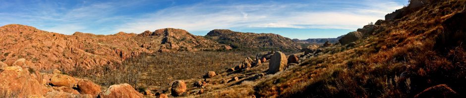
I took in the view to the east and then shot one final panorama looking into the crater and another looking outward. Even though I only hiked 1.15 miles, I thoroughly enjoyed it and will stop here again some day to take in the Boca trail down below, which winds around a lower vent area. But the afternoon was waning, the rain was approaching, and I had far to go. So I wound my way back down the side of the crater, admiring the rounded form of Jose Butte in the distance.

I drove northwest toward the mountains and the town of Raton, where I turned north to cross Raton Pass into Colorado. I decided to exit at Trinidad, which turned out to be another great choice.

Trinidad

Trinidad

This turned out to be a very cute little town of 9,000 which has preserved its historic downtown. There’s the requisite large bank, cute old buildings, the stern courthouse, the Victorian mansion turned into a museum with beautiful grounds, and a proud city hall. And yep, they have many brick streets. There are also many churches, of course, but one which caught my eye was built in 1890 and is now an Italian restaurant. TripAdvisor said it was good, so I parked and went in.

There was an enormous chandelier in the dining area, occupying the former sanctuary. Downstairs was a bar, but my friendly waiter, Julio, seated me in the sanctuary with some female company. The bread and water girl, a tanned college student with admirable décolletage on display, was also a comfort, but I’ll admit I enjoyed Julio’s brilliant smile and gracious manner even more – he made me feel like I was a welcome and honored guest.

Simpson’s Rest

High above the town is a prominent ridge with a big “Trinidad” sign echoing the one I’d seen at Raton. Wikipedia informed me this was Simpson’s Rest and I could drive up there. You betcha!

Princess has almost 195,000 miles on her now, but she got new struts awhile back and I made sure to check the air in the spare tire before the trip, so the steep and rutted gravel road leading up to old Simpson did not deter us from reaching our goal: the DADINIRT sign…oh, I mean TRINIDAD!

Simpson’s Rest

The rocks had the expected graffiti, and poor Simpson’s monuments had their signage stripped and replaced by spray painted scrawls. But both the flag and a bird were flying, the late afternoon sun was shining, and this perch provided a panoramic view of the town below. I posed up top and Princess posed as well, and then we headed back down the slope.

The Orphan and Another Crack

Beautiful clouds to the west adorned my drive northward toward Pueblo. I passed El Huerfano, the Orphan, a lonely butte landmark on the plain.

Along the exit ramp off I-25 for my hotel, a flatbed truck in front of me spat out a stone which created a fresh star in my windshield, a few inches from a previous star created years back. I repaired the earlier one fairly well with a Wal-Mart kit, so tomorrow I’ll see if I can fix the new one in a timely manner. That will delay my trip westward by a bit, but thankfully my schedule at Crested Butte is flexible.

Overall, despite the unfortunate ending, I enjoyed the day much more than I’d anticipated. It is a long hard slog from the middle of Oklahoma to Pueblo, but the stopovers at Capulin Volcano and little Trinidad saved the day.

Click here for a slideshow from this day of the trip

Junebug Day 2: Black Canyon of the Gunnison >

Posted in day hike, photos, travel | 3 Comments

Summer Fiction

June 9, 2012

Beneath the patio parasol, in the rising warmth of the sunny Saturday morning, I read

terse mental dispatches from a female spy of the future, working undercover by the Mediterranean Sea

as told in 47 boxes. The shimmering leaves in the trees whisper to me below the soft drone of a distant lawn mower. I am transported from the blue-black waters of the Mediterranean to one perfect summer of green grass.

The town was, after all, only a large ship filled with constantly moving survivors, bailing out the grass, chipping away the rust… It was this then, the mystery of man seizing from the land and the land seizing back, year after year, that drew Douglas, knowing the towns never really won, they merely existed in calm peril, fully accoutered with lawn mower, bug spray and hedge shears, swimming steadily as long as civilization said to swim, but each house ready to sink in green tides, buried forever, when the last man ceased and his trowels and mowers shattered to cereal flakes of rust.

So what did Ray say about that which finally claimed him? Did something wicked his way come?

Death doesn’t exist. It never did, it never will. But we’ve drawn so many pictures of it, so many years, trying to pin it down, comprehend it, we’ve got to thinking of it as an entity, strangely alive and greedy. All it is, however, is a stopped watch, a loss, an end, a darkness. Nothing.

Yet the stories remain. They endure so long as we read them, remembrances carried by the warm summer breeze.

Posted in books, music, random | Leave a comment

An Afternoon at Osage Hills

June 2, 2012

The second Saturday of my summer break sustained cooler weather which attracted me back to Osage Hills State Park for a long walk. I turned in at the bike trails area, surprised to see ribbons and signs for “Tour de Dirt” but no vehicles. Evidently some sort of biking event had occurred or was forthcoming, but was not yet in full swing.

Tour de Dirt Bikers (click image for slideshow)

I set off down the red loop and a snake, which had been sunning itself in the creek, darted away as I approached. I found that the event organizers had put up tape to direct bikers around the red loop. Recent rains had left a few tiny pools on the creek beds I needed to ford and I passed the large conglomeration I call Turtle Rock. Higher up the hill the creek bed had more pools.

Suddenly several mountain bikers looped past me. I’d see far more bikers on this day in the park than ever before, each of them unfailingly polite in letting me know they were coming and thanking me for clearing out of their way. It turns out the actual racing portion of Tour de Dirt would be the next day, Sunday, so I suppose they were familiarizing themselves with the course.

New Sign

The few flowers I saw were mostly wild petunias. I reached the Osage Trail and decided to head south a ways towards Camp McClintock, wondering if the park boundary was still unmarked. A few hundred feet from the trail intersection I spied a new sign demarcating the boundary and forbidding any but Boy Scouts from proceeding. I like the Scout slogan of Do a good turn daily, but I’m certainly no Boy Scout. So I dutifully turned around and returned to the red loop, discovering that the race organizers had installed a new ramp on the most treacherous portion of the trail.

Not surprisingly there were more pools near The Grotto, although the falls were not running. The trail led onward and I found that the race course diverted to follow part of the blue loop. I trekked onward to the creek and crossed the prairie, noting that the “social trail” shortcut to the tower trail was part of the racecourse. It was beginning to dawn on me that several of the odd trails I’ve noted at the park, sometimes providing shortcuts and other times paralleling the hiking trails, are all part of a mountain bike racecourse used for this event. Just when you think you know everything about a park’s trail system, you learn something new.

I walked to the park office area and bought a Coke by the restroom, then followed the trails to the picnic area which was filled with vehicles of the mountain bikers. I paused to swing for a bit in the unoccupied playground and then walked by the pool, which was helping cool off some of the more portly park guests. I walked down to the Sand Creek waterfalls, where an odd splash caught my eye. My waterproof boots allowed me to walk out into the stream to find the rocks responsible for it. The rope swing over Sand Creek awaited users.

Learning to Row

I walked over to the cliffs, finding people jumping off from there for the first time in my many visits. Mountain bikers are risk takers, after all. I left them alone and walked up and over the hill to Lookout Lake, where a family was struggling with the oars in one boat while behind them Three Men in a Boat fared little better. I tried not to laugh out loud at their struggles, glad to see one fellow give up on rowing and opt to fish.

I wrapped up my walk, having hiked 7.8 miles in about four hours. By the time I was finished, it had warmed up considerably and I was more than ready to head home and shower off the layers of sunscreen, insect repellent, and sweat which I’d built up.

Here’s a video from my afternoon walk:

Click here for a slideshow from this day hike

Posted in day hike, photos, travel, video | Leave a comment

Art and Commerce in Bentonville

June 1, 2012

In late April I first visited the new Crystal Bridges Museum of American Art in Bentonville, Arkansas. But that was a hiking trip and I stayed outside, walking the 4.5 miles of trails on the grounds, saving the art treasures of the interior for a later visit. June began with a rainy day, perfect for touring the art museum in which a Wal-Mart heiress has invested $317 million.

I stopped in Joplin for a tasty lunch at the Red Onion Cafe, which was quite busy. I’d return that evening for dinner at Cheddar’s.

Crystal Bridges Museum of American Art

Crystal Bridges (click image for slideshow)

Once again I had to park in the outer lot and take the pleasant winding Orchard Trail to the entrance. Most of the wildflowers had lost their blooms by now, but there were still some splashes of color. I passed Roxy Paine’s Yield and took the elevator down to the courtyard and entered the museum. I checked in at a booth and paid $10 for the temporary exhibit, “The Hudson River School: Nature and the American Vision”. I could not take photographs in it, but am delighted to report that they had Thomas Cole’s The Course of Empire, a series of paintings I have admired since I first saw a slide of them in my undergraduate art history class at the University of Oklahoma. It was great to see them both in person and displayed properly; I hadn’t realized that the central The Consummation of Empire painting was slightly larger than the others to either side.

I liked several of the paintings in the galleries, which are laid out chronologically, but most of my attention was drawn to the striking sculptures anchoring each area.

Proserpine

Proserpine

Thankfully the rather awful early portraits of the American Colonial period, with their flat amateurish style lacking proper shading and perspective, were accompanied by the gorgeous sculpture Proserpine by Hiram Powers from around 1840. The somber expression of the goddess of flowers, combined with her quite sexy topless emergence from framing acanthus leaves, is alluring. This was the second of five versions of the goddess Powers produced. The first had her emerging from an elaborate basket of spring flowers and later versions had simple beading. Over the years Hiram sculpted almost 200 versions of Proserpine.

The curators had placed a painting of Frances Deering Wentworth by John Singleton Copley nearby, with her décolletage contrasting to that of Proserpine. I also composed my own shot of a silhouetted man, frozen by the beauty before him.

The Choosing of the Arrow

The Choosing of the Arrow

The next section of the first gallery had another wonderful sculpture of the human form, The Choosing of the Arrow by Henry Kirke Brown, from 1849. The musculature of the athletic youth is beautifully portrayed as he bends his arm to retrieve another arrow from his quiver. The handling of the figure echoes ancient Greek and Roman sculptures, but Brown travelled to Mackinac Island in Michigan to observe the Ottawa and Chippewa tribes and his observations led him to include the topknot. He was commissioned by the American Art Union, a New York art lottery organization, to produce twenty casts of this work. Subscribers to the organization had a chance to win gorgeous works such as this.

Free

Free

A later gallery had another striking sculpture, this time a basswood carving from 1876, by Emma Marie Cadwalader-Guild, entitled Free. It depicts a African American slave, now freed, but still feeling the pressure of his bondage as he leans against a tree stump. The carving, her first modeled from life, was perhaps used to help her create a bronze statuette she exhibited in Paris, London, and Munich.

There were some fun paintings by James Henry Beard, including It Is Very Queer, Isn’t It? from 1885, depicting a chimpanzee holding a copy of Darwin’s Descent of Man and ruminating with a chimp skull and human skull nearby.

The Bubble

The Bubble

Harriet Whitney Frishmuth liked to capture motion in her sculptures, so The Bubble bronze from 1928 has a dancer, modeled on Yugoslavian ballet dancer Desha Delteil, manipulating one in her gyrations. I like how the curators illumined the white glass sphere, making it as much of the focus of the piece as the dancer.

Lest you think I ignored all of the paintings, I did take a shot of The Lantern Bearers by Maxfield Parrish in 1908. Those lanterns really seem to glow when you are there standing in front of the work, which he created for Collier’s magazine by using bright layers of oil color separated by varnish, applied alternately over a base rendering. The museum acquired it for $4.3 million.

The Groundhog

One set of galleries were rooms enclosed by a glass-sided bridge with an arced roof, helping me to orient to my surroundings even as I was protected from the light rain. Several of us enjoyed watching a groundhog snacking on one flower after another in one of the exterior plantings. I captured the fun on video.

Other Works

Also fun was the Walking to Borås wood sculpture by Jim Dine, catching Pinocchio in midstride. In the final gallery I was struck by the photorealistic Untitled (After Sam) by Rudolf Stingel in 2006. It is a self-portrait based on a photograph by Sam Samore, showing Stingel in a melancholy state. The photographic appearance of the face and pillow fabric were startling and impressive, requiring that I get very close to the canvas to be able to see it was painted.

A reading area between two galleries had a courtyard window featuring Big Red Lens by Frederick Eversley, a large cast polyester lens he fashioned in 1985. I wish the curators had placed an outdoor sculpture in the courtyard, as that would have been far more interesting to look at through the lens than a set of doors.

One of the more disturbing works in the museum was Rêve (Dream) by Alfonso A. Ossorio. My eye was drawn to the long hairs on the punctured and bound male torso, making me think alternately of snakes, vines, and flames. That part was pinging my gaydar, and Ossorio must have had a feverish dream, what with the unsettling imagery and color scheme.

Crystal Bridges Architecture

I liked the architecturally imposing museum restaurant, a near-twin of the other bridge room but open-air instead of being filled by two large gallery rooms. However, the restaurant entrance featured Claes Oldenburg’s Alphabet/Good Humor sculpture, looking like a giant ice cream bar composed of alphabet pasta, which was not particularly appetizing.

Bentonville

A few blocks away from the museum was the downtown square, home to Sam Walton’s original five-and-dime store which began the Wal-Mart story. I’d visited there with my friend Jeff Silver decades ago and on this day found the square blocked off for ArtsFest, a gathering of booths, food vendors, and musical entertainment. Despite the drizzle it was fun to walk the tiny festival and see one of John Sewell’s erotic carved female torsos, with strategically placed knots, alongside his humorous walking vessel. The Confederacy is represented by a large statue of 2nd Lt. James H. Berry in the center of the square. I ate a funnel cake and then headed home, having enjoyed my rainy day in May…okay, June.

Bentonville

Click here for a slideshow from this day trip

Posted in art, photos, travel, video | Leave a comment

Starting Summer in Redbud Valley

May 30, 2012

Redbud Valley (click image for slideshow)

One of the prettiest walks in the Tulsa metro area is Redbud Valley, an oasis along Bird Creek northeast of Tulsa, just east across the Rogers county line. Its surroundings are much more functional than scenic: to the south is the Lafarge Cement Plant and an industrial area, to the east is Waste Management’s Quarry Landfill, to the north is the quarry for Greenhill Materials, and a few miles to the east is the Port of Catoosa. Redbud Valley is a legacy of Dr. Harriett Barclay, a botanist at the University of Tulsa who valued the many flora abounding on this plot of land with a travertine spring issuing from a high bluff of Oologah limestone. She spearheaded an effort, assisted by the Nature Conservancy, the now-defunct Tulsa Tribune, and University of Tulsa, to preserve this land, which is now part of the City of Tulsa’s Oxley Nature Center.

The trails were built by Boy Scouts and students at the University of Tulsa. My friend Carrie Fleharty first showed them to me several years ago and I’ve been back a number of times, including some visits with photos in October 2009 and January 2011. Fellow science teacher Betty Henderson and I decided to walk the trails on a warm day in late May, celebrating the first week of our summer break and compensating for a float trip with friends which was cancelled by an uncertain forecast.

We ascended the stone steps to the top and crossed the thin-soiled woodland to the prairie, which was alive with grasshoppers and butterflies. We then climbed down the ravine to the base of the long limestone bluff, where we found no water issuing from the travertine spring cavern, which was closed. The trail led along the base of the high bluff, with overhanging rock making the trail fun and scenic. Betty provided some scale for a shot of the bluff and I ventured into a tiny cave opening which was not closed.

Betty and the Bluff

When the trail split, with one part running along the base of the bluff and the other running down along the bottomland near Bird Creek, Betty and I split up, with me taking the bluff trail. I navigated between trees and under long overhangs created by the eroded bluff face. The greenery was abundant, with trees leaning out seeking sunlight. The trail led through large fissures in the bluff face and a huge cleaved rock, one of my favorite spots. The trail neared the end of the west face of the bluff, and then rounded the north end and descended to join the creek trail, with Betty soon appearing for the brief walk back to the parking lot.

The only trail segment we did not cover between the two of us was the Woodland Fork, which is a shortcut bypassing the prairie. It is always a pleasure to visit this oasis nestled in the northeast corner of the metropolis Tulsey Town has become.

Click here for a slideshow from this day hike

Posted in day hike, photos, travel | 2 Comments