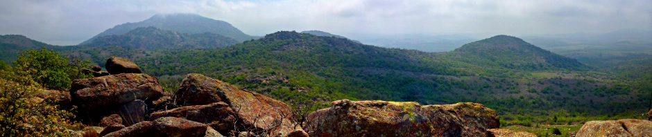
I celebrated the first day of my Spring Break 2012 by hiking five miles at Osage Hills State Park.

Spring Blossoms (click image for slideshow)
I celebrated the first day of my Spring Break 2012 by hiking five miles at Osage Hills State Park.
Spring Blossoms (click image for slideshow)
One of the most popular pages on MEADOR.ORG is the one about the Pathfinder Parkway. Today I received an interesting comment from Bob Curtis:
Hopefully you can help me out. Back in the 50′s/60′s, was there a large asphalt race track located between Tuxedo Ave and Frank Phillips Ave, just about where the orchard is located? I have asked many people about this about this and have always got a no, but I could have sworn that my Dad took me by there one time when I was a kid and showed me it. I believe he said it was not used very often.
Thanks …..
Occasionally I get very specific questions generated by my Bartlesville history pages, but often they are about specific people whom I cannot possibly trace down. But occasionally one of my Bartlesville history books will cough up a clue. The above question seemed answerable by using old maps and aerial photographs, so I took the bait.
First I went to the USGS Store’s interactive map and found the 1971 topographic map for Bartlesville. It did not show anything but the orchard between Frank Phillips and Tuxedo, but it did indicate a small oval track north of Tuxedo, located between the sewer plant and the cement plant. (You can click any of the images in this post to enlarge them to their full scale.)

The 1971 topographic map did show an oval road or track, but north of Tuxedo, not between Tuxedo and Frank Phillips.
Could that be what Mr. Curtis was recalling? I needed some photography to check that out. My next stop was the USGS Earth Explorer where I zeroed in on the same area looking for old aerial photographs. This was more difficult, but I did find imagery of the area from 1954 and 1971. Here’s the area in 1954:

In 1954 there was no orchard, no cement plant, and no racetrack, either.
So in 1954 there was definitely no race track anywhere around there. Instead of an orchard and Blazer ball fields, there was just a farm field. But in 1971 there definitely was some sort of oval track just west of the cement plant:

In 1971 there was a small oval track north of Tuxedo between the cement plant and the sewage plant.
That’s not a huge track, but it is about half a city block in length and bigger than a baseball field. So to a kid 50 years ago it probably seemed much larger than it looks here. Here’s a zoom in on it:

Zooming in on the suspect racetrack.
Hmmm. Perhaps bleachers on either side? Now here’s the same area today:

The orchard area today.
So the area in question is still a clear space, with visible tracks, surrounded by the Pathfinder on the north, the house and field where the horse lives on the west (with the sewage plant farther west of that), the cement plant on the east, and Automasters to the south. I suspect Automasters takes cycles or other vehicles out for a spin on that land.
Here’s a big zoom of the area, showing that the oval thing-a-ma-bob was located just south and east of my favorite bench on the Pathfinder, where I like to sun myself and watch the horse that lives just south and west of there.

Zooming in on that area today.
So I think there was indeed some sort of track there at one time and that is probably what Mr. Curtis recalls from his childhood. I’ll encourage him to go inquire about it at Automasters…they may know something about it. I’m impressed once again by what one can find on the internet if you know where and how to look.
3/15/2012 UPDATE: Patrick Yokley’s father confirms this was a Micro Midget racetrack:
Bartlesville Micro Midget Racers Association was organized in Sept. 1958.
President Johnny Pearson, Kenneth Coonfield
Vice President, Donna Fox Secetary
Treasurer, Lew Fesserman
Business Manager/Promoter and Kenneth Tate Trace
Supervisor/Flagman + a membership of 25 people.
Other members were Jim Clause, Paul Fox, Johnny Hankins, Johnny Sawyer, Curtis Wilkerson, G.B. Brown Jr., Bob Milton, Francis Rourke, Buddy Small, Roy Putman, Jim Cable, Dee Strum, Walt Thompson, Clinton Clopp, Mary Alice Pearson, Virginia Hankins, Kenneth Roland, Eddie Coonfield, Tommy Fresserman, D.C. McKibbin, Tom Carman and Marvin Schaal.
Quarter Midget racing for children was added later. The inter-club competition heats were held on Sundays at the track at the north end of Quapaw. The local track was constructed in 1960 and named “Phillips 66 Speedway”. I do not know what was used prior to this date. I assume they went to other tracks until they could afford to build one.
The track was 1/8th mile oval with medium banks. The long dimension ran north and south. The track was asphalt with concrete and wooden bleachers. The facility had a concession stand, parts and repair services, press facilities, and complete medical facilities manned by two local doctors, Dr. Elvin M. Amen and Dr. Merle D. Fox.
The opening race was on Friday Aug. 21, 1960. It was quite an event. The most well-known entry was Marty Robbins from Nashville, Tenn. Yes, the country and western singer. On Saturday he was leading the race when he was involved in a crash. He was not hurt nor were the other two drivers. Kenneth Coonfield won the race in the twin-cylinder Konigs class.
Even with the low banking, the racers reached speeds of 60 mph in the straight-a-ways and 30 to 40 on the curves. These cars had 19 to 23 cubic inch engines and weighed 320 pounds. The cars cost $400 to $500 to build.
There was an International Championship race held on Aug 19, 1961 with some 150 racers. The prize purse for the event amounted to a whopping $1,500 total. It made it into the major Oklahoma newspapers.
3/18/2012 UPDATE: I walked the Pathfinder a few days after this post to locate what remains of the speedway. The asphalt track is entirely gone, with just a bit of concrete poking through the overgrowth in one area and then there are the overgrown remains of the west and east stands.

West Stands

West Stands

East Stands
10/20/2017 UPDATE:
This post continues to get traffic, and Rich Scaler has kindly shared some great photos he found in a garage sale.
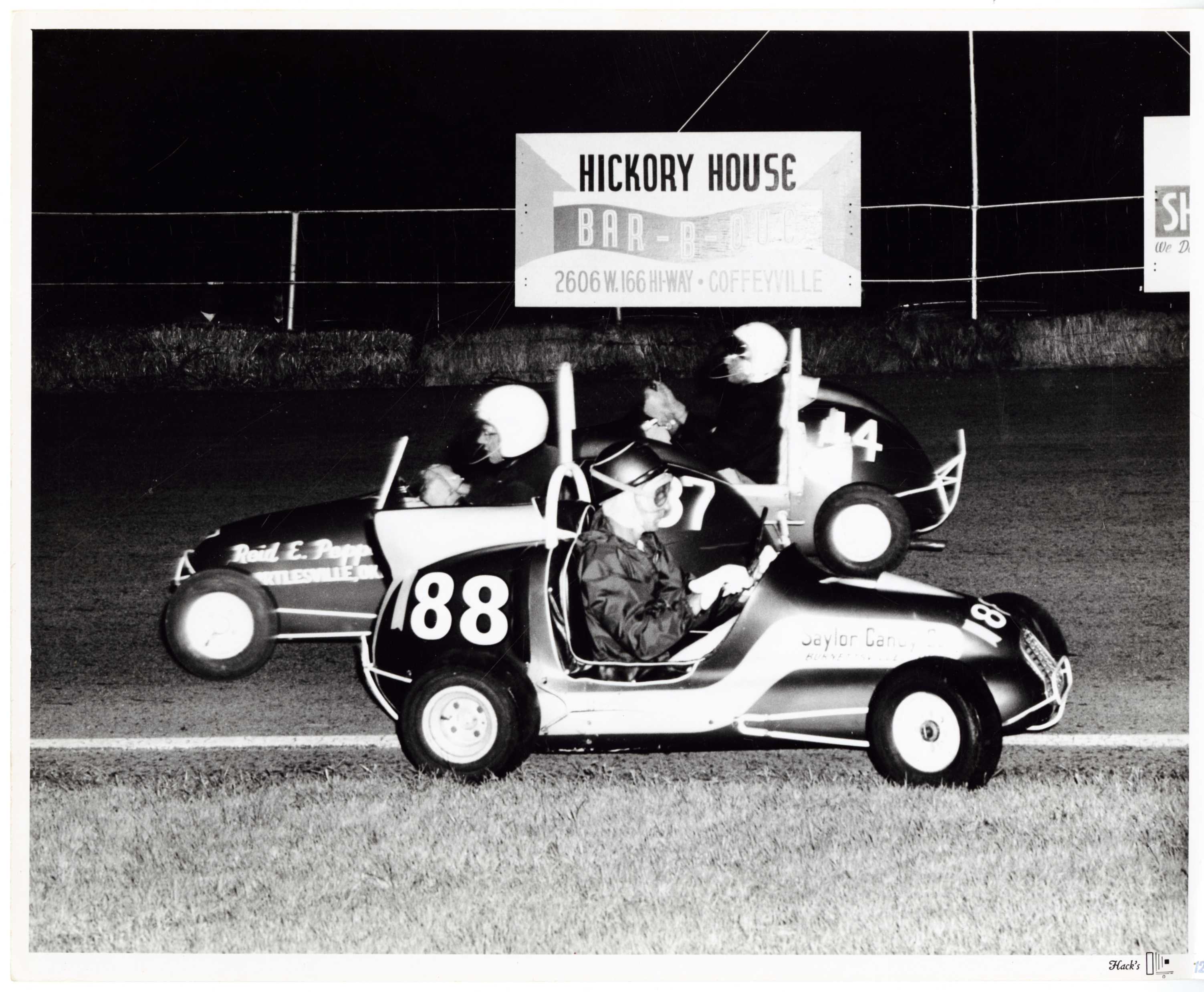
Racing
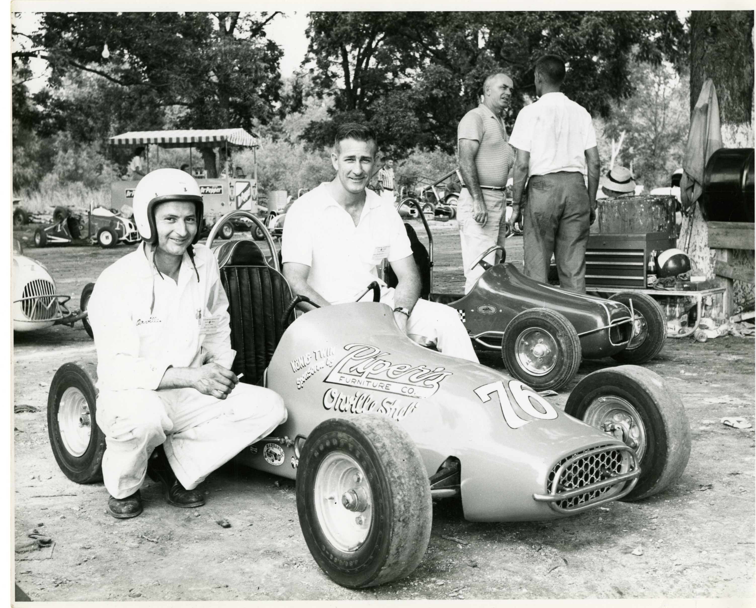
Orville Sheline and Bob Radabaugh in 1964-65

Coming around the curve

Aerial view of a race

El Dorado Lake (click image for slideshow)
Kansas has now passed Missouri in days hiked for me since I started tracking my day hikes in July 2009, but that certainly reflects proximity more than trail quality. The flat topography of the Sunflower State means most of its trails are rather boring, and today’s hikes at El Dorado were no exception. I’m pretty lucky that the Table Mound Trail and Elk River Trail at Elk City, the best ones I’ve seen in Kansas, are so close.
I’d never been to El Dorado, so I presumed it was pronounced like Colorado, but the Kansas incarnation is pronounced El Duh-RAY-doh. The Spanish conquistadors never found their El Dorado, or City of Gold, but I did spot black gold outside of town at the large Frontier Refinery after a 2.5 hour drive northeast.
I was lured to the state park at the reservoir just east of town because it boasts seven trails amidst the Flint Hills. Well, what they call Flint Hills we call Osage Hills, but the El Dorado area is pretty darn flat overall. Frankly I’ll take our Osage Hills state park over the one at El Dorado since even though ours is much smaller, with a pathetic 30 acre lake compared to the 8,000 acre El Dorado reservoir, my interest is hiking trails, and the trails at Osage Hills are far more interesting. The season did not help today’s photography, of course, since there are few signs of spring as of yet.
Before turning off to the park I drove by the Butler County Courthouse in El Dorado, which has a silver figure of justice high above the front veranda. Then I drove over to the lake, locating a self-pay station at the park office where I could purchase the requisite $3.70 daily vehicle permit required to hike any of the trails. My first target was the 3/4 mile Teter Nature Trail, named after the family which owned the area until the reservoir was constructed in 1974. The trail winds through eight acres of riparian timber just east of the Honor Farm, a minimum security correctional facility which closed in 2009.
Like almost all nature trails, the signage was useless. Some was of the numbered type which means little without the never-provided key. Others were small signs denoting tree species, but all but one were broken.
I was glad that the trail quickly left the mown path through a flat grassland to dive down into a creek area, or “riparian” area as the pretentious would have it. I managed to extend my hike here to 1.33 miles by following a side loop until it was completely blocked by a large fallen tree. I bushwhacked back to the main loop and continued on from there. The trail climbed back up the hill and, as it was noontime, I almost lunched on a hillside bench. But the surroundings were so bleak that I decided to wait for a different trail location. The trail soon exited back onto the flat grassland south of the dam and I returned to my car. I decided I should try the nearby trails in the Walnut River Area.
A friendly guardhouse guy at the campgrounds swapped my handwritten day pass for a preprinted one he said would let me drive on through past the other guardhouses, and he gave me a color Lake Guide. I first wandered over to the Big Oak campground, where I parked at the restrooms and walked over the river to the Walnut Hollow day use area. There were a few geese and a few fishermen, with an ADA bridge and concrete trail. I quickly drifted off onto the soft ground beside the trail and made a 0.8 mile loop. The only part of the trail I found particularly photogenic was the campground with its tall trees.
I drove over to the other side of the campgrounds, crossing the river again to take the Walnut Ridge trail. Another bridge took me to where someone had built a stick shelter out of a fallen tree. I startled a deer, which made a gorgeous leap across the brush which I naturally could not capture in the camera. I found a big tree with bridge and bench which made a decent lunch spot. A stream had eroded its bank to show two trees with intertwined roots.
Sadly the trail was soon over and the next section was a wide concrete path snaking over to the aptly named Linear Trail. The daunting perspective looking either way along the trail was less than appealing in my hiking boots. I was glad to find a grassy trail paralleling the Linear Trail and followed it while freight trains rolled by on the busy Union Pacific railway to the northeast. I reached the dam and climbed up top, taking another series of out-of-focus shots with my camera. I am eager for the new Canon superzoom camera to be released this month so I can assess its reviews and see if it can replace my dysfunctional Panasonic one.
The camera behaved better when I drew abreast of the Linear Trail, allowing me to shoot its straight shot to the southwest. I descended, determined to stray from the line, which I did by ducking off to the Black Diamond bike trail. Soon I was surrounded by birds flitting from branch to branch ahead of me as I walked past tall trees in the bottomland. Soon I was back at my car, having hiked 2.5 more miles.
I drove east to the lake overlook, built with more style than most. I had to agree with some graffiti since I love “summer” too, although I do always seek an escape from the scorching heat in these parts. The shelter did its best to make the lake view more interesting. I drove over to the Shady Creek trail, but it looked very short and dull, so I turned about and drove up the western shore of the lake to the far north end of the Boulder Bluff Equestrian Trail, lured by a note of a Rock Quarry Area.
Sure enough, an old quarry there had been flooded by the lake, and a fisherman was plying its depths from one bank. The eroded limestone along the shore was interesting, with stumps and other flooded tree remains poking up out of the water out past the quarry cove. Leaving the flooded forest, I crossed to the other side of Quarry Cove, climbing up over the hillside and down to a point with huge eroded slabs of pockmarked rock.
I’d tacked on another 0.9 miles, bringing my total at El Dorado Lake to 5.5 miles. I exited the area, passing a wading fisherman. I wasn’t tired of hiking, but I’d exhausted everything but the long equestrian trail, which made an unappealing run beside the railway. So I drove back to Sedan, Kansas where I’d passed hiking trail signs at the city lakes.
It turns out that there is an old road from the Old Sedan City Lake to the new one a couple of miles to the south which has been turned into a hiking trail. I turned off at the north entry road to the old lake, finding it was a 1935 relief project for local and transient laborers. They’d built up long rock walls with interesting buttresses and caps. The spillway creek area had some nice erosion. I climbed down for a closer look, but the confounded camera loused up all of those shots.
I hiked down the old road toward the new lake in the dimming light, reaching the north end of the lake to capture the sun lowering through the overcast sky and shooting the smoky clouds. Then I trotted back along the road since dusk was approaching, managing to slip on the trail once and fall, muddying my jeans. An ignominious end to a somewhat disappointing day, but I did manage to boost my hiking total for the day to eight miles.
I’ve done enough Kansas hikes to last me awhile. Geography has led me to conduct most of my hikes to the southeast of Bartlesville, and my focus shall now return there, except for a possible expedition to Black Mesa during Spring Break.

Léo doing a podcast in the TWiT Cottage (Photo by Ron Schott)
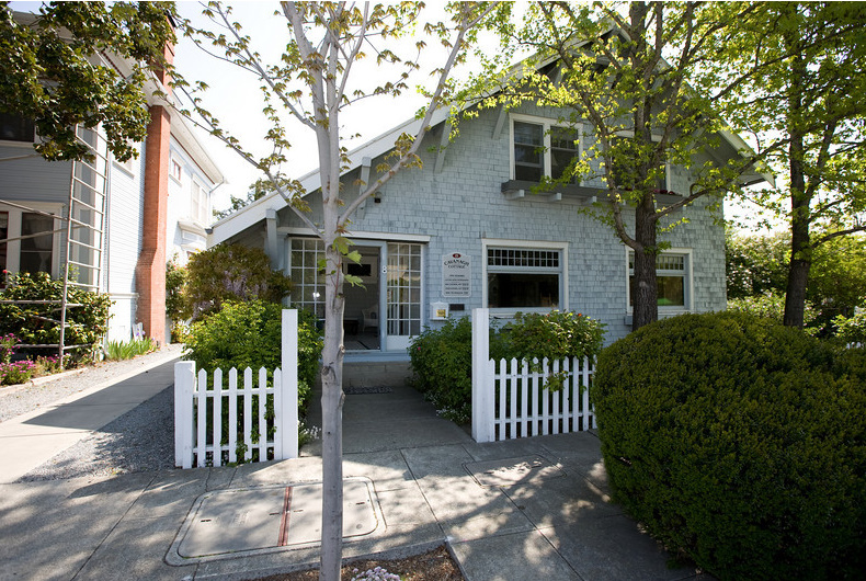
The TWiT Cottage where it all started
For years I listened to his audio podcasts on my iPod and then my iPhone. He started broadcasting video along with the audio, and I would sometimes watch the video versions on my Apple TV or iPad.
But I started regularly watching the video versions once I had an iPad 2, especially since it can send the videos over to my HDTV via AirPlay to my second generation Apple TV. I can now effortlessly switch back and forth between the tablet and the big TV.
I regularly watch these TWiT shows:
Léo built up from a single show recorded in a tiny garret studio in a cottage. He steadily added more shows and hosts, eventually taking over the entire cottage and ramping up to several million dollars per year in advertising to support a franchise of over 30 weekly and daily netcasts, all centered around digital technology in its various forms.
The staff grew commensurately and were soon filling up every nook and cranny of the tiny cottage. So Léo recently spent over $1.2 million renovating an old furniture factory building into the TWiT Brick House studio.

The new TWiT Brick House studio (great HDR photo by Trey Ratcliff – click to enlarge)

The new TWit Brick House studio and the location of my brick in the wall
I’ve done my bit to support all of the infotainment his shows provide by donating monthly to the cause and by purchasing a brick in a fundraiser to help build the new studio. The bricks are displayed in the lobby, and they posted GigaPans so I could find where mine wound up.
It is fun to see it mounted there since I have no idea if I’ll ever make it out to Petaluma to see a show live. If you love technology, check out TWiT.tv!

The Brick House before the remodel

Lobby of the TWiT Brick House
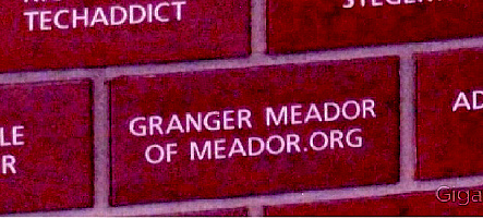
My brick in the wall at the TWiT Brick House
POSTSCRIPT:
This isn’t the first fundraising brick I’ve purchased. Downtown Bartlesville’s Centennial Park features this:

My brick in Bartlesville’s Centennial Park

This year I’m picking out a new favorite song for each month. New to me, that is, not necessarily new to the world! Last month it was Florence’s Shake It Out.
In February I discovered Duffy’s song Mercy and absolutely LOVE it and recommend the entire Deluxe Edition of the Rockferry album from which it came in 2008. Here’s the official video:
 I first heard it while sitting in a booth at Garfield’s, finding my shoes flitting back and forth and my head bobbing and nodding uncontrollably. My iPhone’s SoundHound app identified the song for me, which I downloaded on the spot from iTunes and began pounding in the car as I drove away.
I’m recommending the whole album, which is chock full of retro-pop breakup songs penned by Duffy with several different talented songwriters. Mercy is by far the snappiest song of the bunch, but others also show Motown and other rhythm and blues influences along with echoes of Dusty Springfield, Carole King, Phil Spector, and more. Personal favorites are I’m Scared, Stepping Stone, Rain on Your Parade, Stop, Serious, and Distant Dreamer. The title track, Rockferry, is a bit overwrought for my tastes, however.
Mercy
(Hit the beat and take it to the verse now)
Yeah yeah yeah
Yeah yeah yeah
Yeah yeah yeah
Yeah yeah yeahI love you
But I gotta stay true
My morals got me on my knees
I’m beggin’ please
Stop playin’ gamesI don’t know what this is
Cause you got me good
Just like you knew you wouldI don’t know what you do
but you do it well
I’m under your spell.You got me beggin’ you for Mercy (yeah yeah yeah)
Why won’t you release me (yeah yeah yeah)
You got me beggin’ you for mercy (yeah yeah yeah)
Why won’t you release me (yeah yeah yeah)
I said release me (yeah yeah yeah)Now you think that I
Will be somethin’ on the side
But you got to understand that I need a man who can take my hand
yes I doI don’t know what this is
but you got me good
just like you knew you wouldI don’t know what you do
But you do it well
I’m under your spellYou got me beggin’ you for mercy
Why won’t you release me
You got me beggin’ you for mercy
Why won’t you release me
I said you better release me (yeah)(overlay)
(You look at me and think we’re the same kind
Cause you don’t know what I’ve got in mind
I want a bit more than I’m asking for
But I just don’t want to waste my time
You think that I’ll be the other girl
Just like there’s nothing in this world
I wanna have fun, go get me some
I just don’t know where you’re comin’ from)I’m beggin’ you for mercy
Why won’t you release me
I’m beggin’ you for mercy
You got me beggin, you got me beggin’, you got me beggin’Mercy
Why won’t you release me
I’m beggin’ you for mercy
Why won’t you release meYou got me beggin’ you for Mercy
I’m beggin’ you for Mercy
I’m beggin’ you for Mercy
I’m beggin’ you for Mercy
I’m beggin’ you for mercyWhy won’t you release me yeah
yeah
break it down





 Meador Manor