For 2012 I’m going to pick a favorite new song each month to share: my favorite discovery of the preceding month, be it old or new and no matter what genre it occupies. At 45 I’m hardly the youth I was in high school and college, aware of all of the top hits, even the ones I despised. Now I have no earthly idea of what is popular since I no longer have music television or bearable radio stations to inform me.
Modern technology could come to my rescue if I were into Pandora or Spotify or other streaming music services. But the over ten thousand songs in my iTunes collection keep me satiated so that I have to actively decide to seek out something novel.
Regrets collect like old friends
Here to relive your darkest moments
I can see no way, I can see no way
And all of the ghouls come out to play
And every demon wants his pound of flesh
But I like to keep some things to myself
I like to keep my issues drawn
It’s always darkest before the dawn
And I’ve been a fool and I’ve been blind
I can never leave the past behind
I can see no way, I can see no way
I’m always dragging that horse around
And our love is pastured such a mournful sound
Tonight I’m gonna bury that horse in the ground
So I like to keep my issues drawn
But it’s always darkest before the dawn
Shake it out, shake it out, shake it out, shake it out, ooh woaaah
Shake it out, shake it out, shake it out, shake it out, ooh woaaaah
And it’s hard to dance with a devil on your back
So shake him off, oh woah
I am done with my graceless heart
So tonight I’m gonna cut it out and then restart
Cause I like to keep my issues drawn
It’s always darkest before the dawn
Shake it out, shake it out, shake it out, shake it out, ooh woaaah
Shake it out, shake it out, shake it out, shake it out, ooh woaaah
And it’s hard to dance with a devil on your back
So shake him off, oh woah
And it’s hard to dance with a devil on your back so shake him off
And given half the chance would I take any of it back
It’s a fine romance but its left me so undone
It’s always darkest before the dawn
Oh woah, oh woah…
And I’m damned if I do and I’m damned if I don’t
So here’s to drinks in the dark at the end of my road
And I’m ready to suffer and I’m ready to hope
It’s a shot in the dark and right at my throat
Cause looking for heaven, found the devil in me
Looking for heaven, found the devil in me
Well what the hell I’m gonna let it happen to me
Shake it out, shake it out, shake it out, shake it out, ooh woaaah
Shake it out, shake it out, shake it out, shake it out, ooh woaaah
And it’s hard to dance with a devil on your back
So shake him off, oh woah
Shake it out, shake it out, shake it out, shake it out, ooh woaaah
Shake it out, shake it out, shake it out, shake it out, ooh woaaah
And it’s hard to dance with a devil on your back
So shake him off, oh woah
I spent most of January 2012 fighting sinusitis, unable to take advantage of unseasonably warm weather for day hikes. Finally, four weeks after my previous day hike on New Year’s Eve, I had recovered sufficiently to contemplate hiking on the final weekend of the month, which again arrived weirdly warm, reaching the upper 50s on Sunday.
I knew I didn’t want to travel too far, yet I hoped for something novel. A perusal of the map showed I’d exhausted most of the nearby opportunities in Oklahoma. So I scrolled the map north into Kansas. Many months ago the husband of my friend and coworker Betty Henderson had mentioned there were trails at Big Hill Lake near Cherryvale, and I settled on them.
I spent Saturday doing laundry and reading a thin volume Betty had given me: The Benders: Keepers of the Devil’s Inn. It told the particulars of a group of four serial killers, an older couple and a younger couple, who set up a one-room Hell House on the Prairie near Cherryvale in the early 1870s and set about doing away with passersby on the Osage Trail linking Independence and Fort Scott. They evidently murdered 17 people over three years, mostly by hammering in their skulls and slitting their throats. They successfully fled the scene before locals caught on and were never held accountable. The house was dismembered by souvenir hunters, but their hammers are in the Cherryvale Museum and almost all of their victims are buried at Benders Mounds just north of Big Hill Lake.
I wouldn’t be driving by those mounds, but instead focused on the Ruth Nixon hiking trail located five miles south of them along the west shore of the lake near the dam. There is also a 17-mile bridle trail around the north end of the lake, but I couldn’t find any online trail maps, just a biking trail site saying the bridle trail is shaped like an H with the cross-segment along a gravel road across the lake called Rea Bridge. So I wasn’t sure if I could reach the bridle trail from the Nixon trail or not.
I arrived at the dam overlook at 10:15 a.m. and followed the signs to Pearson-Skubitz Big Hill Lake. Only a government bureaucrat could think of such a terrible name. Everyone really just calls it Big Hill Lake after the Osage Indian leader Pa-In-No-Pa-She (Not Afraid of Longhairs), or Big Hill Joe as he was known by whites. The band of Osage Indians he once led lived in a village a few miles to the northwest before their land was purchased/stolen and they were shifted south into Oklahoma in 1872. I have no idea who Pearson or Skubitz were; Public Law 95-625 gave the lake that terrible prefix without bothering to say why.
It turns out my camera was not focusing properly for the first part of my hike. I suppose it is as out of practice as I am after weeks of convalescence. So my shots of the arched observation platform and panorama from it had to be sharpened in Photoshop. I located the south trailhead for the Ruth Nixon Trail nearby, with a nice big trail map sign revealing that the trail hugged the shoreline northward to one of the parking areas for the bridle trail. So I could extend the roughly one-mile trail from there.
I was immediately greeted by a broken-down bridgelet and the discovery that the trail area had been burned over. So it is no great tragedy that my camera was on the blink and I can only offer post-sharpened images of the denuded surroundings and a burned-down tree. I trudged northward to where the lake has not been cleared for boats and finally reached a long fishing berm where the trail came to an end. I located the bridle trail parking area, where I was told the trail was closed from 10/30-12/11 and 1/1-1/8 during the firearm deer seasons. I was well out of that, so I continued northward some distance from the lake on the blue-blazed horse trail.
The trail followed the fence line long enough to worry me that it would not be worthwhile, but then turned toward the lake. Along here I spooked a group of five deer a couple of times, seeing their white tails rapidly bobbing away.
I’d not used the many benches along the Nixon trail and wondered where I’d sit down for lunch, but then right about noon I found a sawed stump where I could sit down and eat. After continuing northward only a bit more, I began hearing many nearby gunshots. They were close enough to be unnerving and I donned my orange cap and vest and reversed course back to the trailhead, finding an alternate route to avoid most of the fenceline section. I hope those shooters were having better luck than I: hours later, when I downloaded what I had in my camera, all I found was a blurry mess.
I’d hiked 7.75 miles but it wasn’t even 2 p.m. yet. Based on the poor winter scenery and gunshots I had no interest in hiking other parts of the trail system, but I had read about a new trail system being constructed just north of Parsons at Tolen Creek at the junction of highways 59 and 400. So that would be next.
I drove half an hour over to Parsons, pausing to look at the doughboy at the courthouse and then found the unmarked turnoff for the Tolen Creek Trails. This area is under development, with wide gravel trails and associated bridges under construction. It is currently somewhat unprepossessing and afflicted with highway noise, but once the trails are finished and more grass is planted it will make for a fairly pleasant two-mile walking loop excepting the noisy aural environment.
I liked how they had curbed the trail around the big fishing pond with rough rocks; I don’t know if they plan to line the entire trail that way, but it would make it look nicer. A new bridge with a bowed rail plank led across the creek to the unfinished east part of the property, which wound around to two more large bridges where I encountered some fellow walkers.
So I headed home, stopping off in Independence for a refreshing dipped cone at the Dairy Queen. When I arrived home I could tell I was out of shape from my month without any hikes and collapsed for a short nap. I quickly recovered, however, and was ready to edit photos and compose the blog post. I’m rather disappointed that my camera, which up to now had been a strong performer, is having focusing issues. Most of my later shots at Tolen Creek were fine, but a few showed the same lousy focus which plagued all of the shots at Big Hill Lake. It may be time for a new camera. If I do invest in one, I’ll steer away from a Panasonic Lumix this time, although I’ll insist on another pocketable one with superzoom and built-in GPS.
I wasn’t a big comic book collector, but I did read DC 3-packs in the early to mid-1970s. Marvel comics never caught on with me – their artwork seemed cruder to my eyes and I didn’t care for all of the bickering and angst amongst its characters…too much drama!
The front and back books of my DC 3-packs were usually Justice League of America and Action or Detective Comics (aka Superman or Batman) while the middle would be some lesser title like Superboy or Green Lantern/Green Arrow. Since I only had a couple dozen or so comic books in all, I read and re-read some of those comics again and again, enough that images from several of the stories lingered over thirty-five years later.
My comic books were discarded decades ago, and although I would sometimes wish I’d kept Dagger in the Sky and other tales, I presumed I’d never see them again. Comics were printed on cheap paper and how could you possibly sift through the hundreds of titles at a comic book shop and hope to find the few you fondly remembered?
Well, the internet puts everything at your fingertips these days. Online databases let you see the covers from any mainstream comic book and you can then use that info to track down a digital download. Recently I’ve re-acquired a number of titles from my youth and enjoyed revisiting their artwork, if not their juvenile storylines.
You can click on any of the images here to enlarge them.
Memorable images from my youth
Dagger in the Sky from 1972’s Superman #256 was the story I remembered best. I was always struck by that plane-shaped hole ripped through the fabric of spacetime.
Dramatic action
And the dramatic take-off of the jet from the hanger lingered in my mind’s eye as well. I loved Superman stories where he used his brains as well as his brawn, since Superman was enough of a deus ex machina himself without needing silly assistance from robot Supermen and other junk from his Fortress of Solitude. I disliked stories involving kryptonite, especially the many weird variations, and despaired when Mr. Mxyzptlk would make another annoying appearance. Gosh, did I really like Superman? Doesn’t sound like it, does it?
First person shooter
The next month brought Detective Comics #428 with a dramatic first-person shooter cover. But I was never as fond of Batman as I was of Superman. I loved the campy Batman TV show, but the comics of the 1970s were a very different take on the caped crusader. They were dark and seething with rage, although not as down and dirty as Frank Miller’s influential 1986 The Dark Knight Returns, which truly isn’t my cup of tea in storyline or artwork. And while I liked the first of the Tim Burton Batman movies, they went downhill fast. The new Christian Bale movies are better, but are also quite grim.
A noirish Hawkman caper I liked
That same 1972 issue of Detective Comics had a moody noir-style Hawkman story which I liked for its somber atmosphere. I never read much of Hawkman, but that particular short tale stuck in my mind.
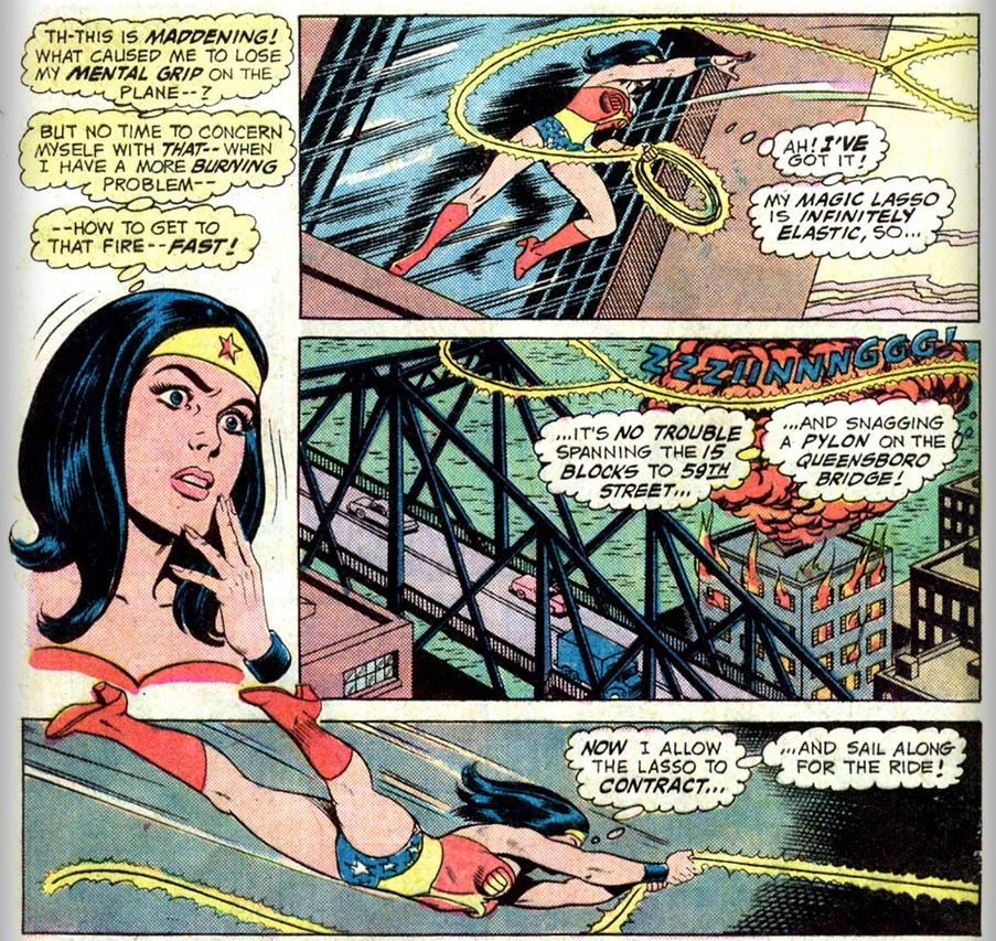
I always preferred Justice League of America stories to the comics dedicated to a single character. They had more variation in style and content. I was no doubt influenced by the Super Friends television show, and Wonder Woman in the comic books was a far more interesting female character than anyone in the sappy Superman Family comics, even if she was rather dull in Super Friends.
Wonder Woman was the brainchild of William Moulton Marston, a Harvard-educated psychologist and lawyer and inventor of the lie detector. That explains the magic lasso’s truth-telling power, but Charles Lyons points out that “Marston filled his stories with bondage (both male and female), spanking, sorority initiation rituals, cross-dressing, infantilism, and playful domination.”
Wonder Woman in a typical act of bondage
Lyons offers up a revealing comment by Marston in 1946:
Tell me anybody’s preference in story strips and I’ll tell you his subconscious desires…Superman and the army of male comics characters who resemble him satisfy the simple desire to be stronger and more powerful than anybody else. Wonder Woman satisfies the subconscious, elaborately disguised desire of males to be mastered by a woman who loves them.
She'd changed some by the 1970s
The original Wonder Woman
Wonder Woman changed styles with the times, starting out with a 40s hairstyle and ruffling skirt which were long gone by the time I read her tales in the 1970s Justice League comics.
But she retained her habit of either getting trussed or chained up herself or gleefully doing it to others.
A Sexy Superboy?
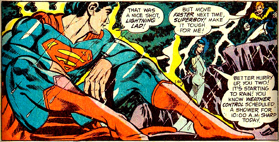
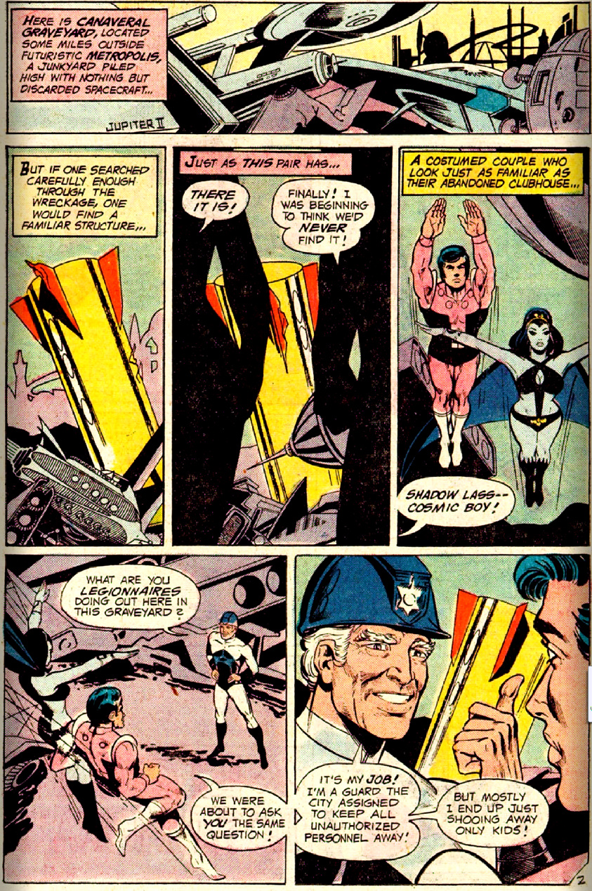
The most sexualized artwork I read as a kid was, oddly enough, in Superboy. Even at age 9 I could pick up on some of the homo- and hetero-erotic vibes. We all know what those teenage superheroes were really up to, don’t we? The costuming left little to the imagination, for males or females, but as a prepubescent I was no doubt even more distracted by the visual Star Trek references in their spaceships. The female costumes were also a reminder of 1960s Star Trek: the outfits, or lack of them, which Bill Theiss draped over the guest stars.
Your place or mine?
She used too much bleach when washing her costume
Which is stranger: Cosmic Boy's outfit or the junked U.S.S. Enterprise?
The 1970s were part of the Bronze Age of comics. The Golden Age had ended in the 1950s with the attacks by Fred Wertham and the consequent Comics Code. The Silver Age had brought back many superheroes in revamped costumes and modernized origin stories. The Bronze Age I grew up in added more self-consciously darker and “socially relevant” storylines, which did little for me.
I certainly didn’t like all of the parallel worlds that built up in the storylines to explain away various contradictions. Eventually DC had the Crisis storylines of the 1980s which revamped all of the continuity. I wasn’t reading any comics by then, so I missed out on all that. And I also missed out on the switch from mass comic reading by kids to avid collecting by adults. Readership declined but revenue was bolstered by special editions and collectors.
The only time I read any comics after elementary school was when I heard Superman died. I picked up a graphic novel collection of the follow-up storyline of Superman’s return, struggling to decipher its maze of alternate Supermen and the like. It really didn’t seem worth the effort in the end; the artwork was impressive, but the convoluted tales certainly weren’t nostalgic for me, being far removed from what I’d read as a kid.
Some years later I was convinced by a highly positive mention in Time to read the Watchmengraphic novel, which was extremely dark but also a great story. I also read the first Sandman books, but although Gaiman is a great author they got a bit too ethereal for me.
Then DC announced a few months ago that it was completely rebooting its entire line, discarding all of the old continuity and starting fresh. They’d also be offering their new line in iPad-friendly versions with the same kind of auto-panning and zooming that Marvel had in its digital line.
That sounded intriguing since I could just download a few books on my iPad and not have to worry about the overload of ponderous continuity from decades of stories. Two of my favorite television franchises, Dr. Who and Star Trek, suffered from such problems of backstory overload, although I was an avid enough watcher of every Trek series to keep up with the dizzying complexities.
The New 52 at DC has a rather digital look. And Wonder Woman is like money: always inflating.
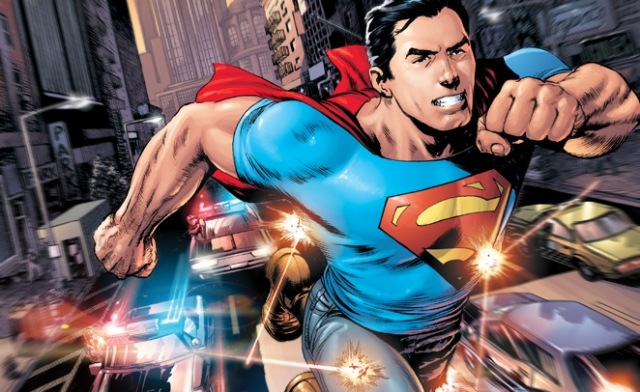
So I’ve bought and read the first three of the new Action Comics with Superman. He’s weaker than before and in this storyline hasn’t really figured out how to be a superhero yet and is leaping about in jeans, not flying around in full spandex. It’s actually been fun and I’ll keep reading it for awhile until I tire of it.
The New Action Comics
There is a separate Superman comic book line where it appears he’s older and more polished with more stuff about Krypton, but that doesn’t interest me. And I’ve sampled and rejected The Savage Hawkman and some Marvel comics. I’m just not the target audience for most of this stuff. The fact that I complain more than praise throughout this article is a giveaway that comics really aren’t my thing, although I like bits and pieces.
I’ll wrap up with something interactive you can try if you like. I found a silly online quiz that supposedly identifies which superhero you most resemble in terms of your personality. Here’s what I got:
You are Green Lantern
Green Lantern
65%
Superman
55%
Spider-Man
55%
Hulk
50%
Robin
50%
Iron Man
40%
The Flash
30%
Supergirl
25%
Batman
25%
Wonder Woman
15%
Catwoman
10%
Hot-headed. You have strong
will power and a good imagination.
Well, I never really cared much for Green Lantern (let alone this summer’s movie version which I wasted money on), but I have to admit that while I don’t want to read about it, if I had to live it I’d prefer a magic ring to bare knuckled fisticuffs. And having to keep that darn ring charged up isn’t all that different from keeping the iPhone and iPad ready to go, is it?
I’ll wrap up 2011 with a lengthy post about four trails I hiked at Lake of the Ozarks on the last day of the year.
Coping with Hotel Living
Earplugs are my strategy for some hotels. The new one I stayed at in Osage Beach was, as reported in online reviews, run by a friendly couple but suffered from poor architecture. It had a large central corridor which functioned as a resonance box for the indoor pool at one end and all of the inevitable slamming doors from typical thoughtless guests. But my earplugs kept me undisturbed, the bed was comfortable, and the continental breakfast was varied and fresh. It’s a shame earplugs can’t compensate for a cramped bathroom, but it was a budget hotel after all.
Lake of the Ozarks Area
On the last day of 2011 I’d hike on four different trails in the Lake of the Ozarks State Park, straddling it with hikes at the west and east end. These added to the previous day’s hike there and a hike in September 2010 at nearby Ha Ha Tonka. I haven’t exhausted the trails in this area, so I’ll be back in 2012. The long drive from Bartlesville means I will need to stay at an area hotel, so I might try returning here over Spring Break. I wouldn’t like the big summer crowds.
Grand Glaize Trails
By 8:45 a.m. I was on the first trail, which was only a few miles away in the Grand Glaize area on the west edge of the state park. The area name refers to a flooded creek but the origin of the name is uncertain. It lies only a few blocks east of the south part of Osage Beach (aka Laguna Beach), and the area is known for its summer partiers. The state has redesigned the park entry road, which fooled Trixie the GPS, but I had little trouble finding the trailhead for the Rocky Top Trail, a 2.5 mile double-loop.
Okay, I apologize for that. Let’s get back to the trail…
It was still in the 40s so I opted to walk the trail so that I’d be in the sunlight along the lake shore for the start of my hike. I walked past a shelter and down to the shore, where a bright sun was climbing the sky. A fisherman was standing in his boat close to shore and we waved as the trail hugged the shoreline. I reached the waterway which separates the two trail loops and crossed it so I could ascend the adjacent hill to an overlook. The trail, like both of yesterday’s, followed a ridgeline to a point. But this time it was a broad high cliff providing a sweeping eastward view of this arm of the lake.
I knew the nearby Shade Ridge Trail would be less interesting, as it simply hugs the lake shore connecting the marina to the Pa He Tsi area. But it was so close I couldn’t pass it up, so I drove over to the trailhead, discarded my heavier jacket and ear pops since the temperature had climbed into the 60s, and crossed a short bridge onto the trail. It hugged the lake shore part of the way, providing ready access to the water where I could see a fishing boat silhouetted by the glare of the morning sun. Along the trail there were pleasant views of the lake developments. I peered down into a fallen log’s maw, but thankfully nothing came popping out at me.
Squirrels scampered about, as they had on parts of the earlier trail, but they were skittish and would not pose for the camera. I forded a small steady stream and arrived at the closed entrance to the Pa He Tsi area. The name refers to the Big Osage tribe or “campers on the mountain” in contrast to the Little Osage or U-ʇseɥ-ta or ‘”campers in the lowlands”.
I was craving pizza and Yelp said there was truly excellent pizza to be found at the Alley Cats bar to the north in Lake Ozark. I don’t care for smoky bars, but the lure of crispy tasty pizza was irresistible. So I made my way over, finding I had to cross Bagnell Dam. The half-mile long dam was constructed by Union Electric of St. Louis from 1929-1931 and rises 148 feet from bedrock (so it’s about twelve stories high and seven blocks long). It was named for the town site where it was built, which of course is gone today. At full capacity 30,000 gallons of water can flow each minute through each of the dam’s eight turbine generators, producing 215 megawatts of electrical power.
The dam impounds 600 billion gallons of water and forms over 1,150 miles of shoreline along what the company called the Osage Reservoir, the Missouri legislature named Lake Benton, and everyone still insisted on calling Lake of the Ozarks: the largest man-made non-flood control lake in the country. Since the lake level is very steady, unlike many flood control lakes built by the Army Corps of Engineers, the shorelines have been intensively developed by private interests. Recently the Federal Energy Regulatory Commission ruled that many structures are actually on utility-owned land and ordered thousands of home and businesses to be moved, causing widespread concern and consequent clarifications.
The main road into Lake Ozark, a tourist strip replete with restaurants, bars, and shops, runs over the narrow top of the dam which clearly was meant for smaller cars. You are supposed to creep along at 25 miles per hour, which I dutifully did to the dismay of several young fools behind me, who recklessly zipped around my car both before and after we crossed the dam. I certainly wouldn’t want to be around here in the summer swarm. I’ll take a lonely forest or mountain trail over swarming crowds of tourists any day.
The bar was small and a bit smoky, but the pizza was superb. The bartender proudly pointed out the huge trophy they had won in a pizza cook-off and I had to agree that it was some of the best pizza I’d ever had. Bikers pulled in and drank as I happily consumed my hot, thin, and crispy mushroom confection.
I recrossed the narrow dam and drove up to an overlook. The electric utility had put up a nice set of displays and a viewing platform, along with one of the massive old turbines. The 1931 turbine is cast steel, weighs 50 tons, and rated to produce 33,500 horsepower at 90 feet of water pressure at 112.5 rev/min. I know, only a physics teacher could love such statistics!
It was time for the afternoon hike, which I planned for some hiker/equestrian trails at the stables on the east side of the huge state park. I reached the empty Hidden Springs Trailhead at 1 p.m. and set off down the wide trail. Thankfully there was little prominent manure and I enjoyed the wriggling descent down toward the lake. Now it was the afternoon sun forming my silhouette as I strode through tall trees past an almost illegible sign which read “Half Way There”.
In front of some low islands a number of birds were lined up along a floating log in the lake. The wind was whipping and I hung onto an odd tree arch on the promontory before climbing back up to the zigzagging trail. I reached an intersection with the south loop of the immense Trail of the Four Winds. The south loop is 9.25 miles long while the north one is 4.25 miles and the 13.5 mile trail is clearly popular with equestrians since there had been a number of horse trailers at its trailhead.
This part of the long trail led down toward the water. Eager to get a better look at the birds, I followed it down. Ferns were growing alongside the trail and I reached the shore where I could see birds fishing in the water, riding the stiff wind and diving to the water after prey.
I followed the Trail of the Four Winds for a couple of miles, passing high bluffs and then making a winding ascent between waterways, but the views were limited and I finally decided to turn back. Rather than wind my way back around the waterway I bushwhacked down it and across, finding more tree fungi in the form of wide white fans. An opossum beside the trail eyed me warily as I passed, but wasn’t scared enough to play possum. I trudged back up onto the Hidden Springs Trail and eventually the Trail of the Four Winds split off and I returned to my car for the long drive home.
Day Hike Statistics
It had been a satisfying end to 2011, with me tacking another 9.5 miles onto my day hike total, bringing it up to 326.3 miles for the year. Since I hiked 50 days in 2011 that averages to 6.5 miles per day. I continue to rack up many auto miles finding new trails, having exhausted so many trails since July 2009. Since then I have hiked 56 days in Oklahoma, 23 in Arkansas, 11 each in Kansas and Missouri, 9 in Oregon, 8 in Colorado and 3 in New Mexico. But there are still some unexplored trails in Oklahoma and many more in Missouri and Arkansas beckoning my boots. Summer vacation continues to be a great time to pick up more trails in Colorado or the Pacific Northwest and escape July in Joklahoma.
I’m still eager to get out and walk about, shooting pics and listening to audiobooks. I agree with Nate Desmond of Practical Manliness about the benefits of day hiking, but for me #5. Relieve Stress ranks above #3. Foster Relationships since I use solo day hikes as a chance to escape from people and work, indulging in my own favorite pastime. But I’m not a complete loner: I do share my photos and write extensively about each trek. I know some folks who just look at the photos, some who read every detail, and several of my friends never look at my posts, period. And that’s just the way it should be. As Cicero wrote, “Suum cuique pulchrum est.” To each his own is beautiful.
The forecast called for unseasonably mild weather for the final two days of 2011, so I decided to try again for day hikes at Lake of the Ozarks. I tried to do so last May but rain changed my plans. The sprawling lake is over 4.5 hours from my home, so I needed to stay in a local hotel overnight. This time I opted to first try for some trails at Pomme de Terre Lake about 45 miles southwest of the larger lake and stay overnight at Osage Beach, hiking at the Lake of the Ozarks the following day.
The sun ascended as I drove along narrow old US 60 to Nowata. Road work forced me on a long detour south to Chelsea, where I had to wait on a long freight train. Chelsea is where Oklahoma’s first oil well was drilled, although the first commercial oil well was drilled in Bartlesville. I finally reached Vinita and I-44, which took me up to Springfield where I bought gas and a Lunchable and headed north to Pomme de Terre.
The fancy French name translates to “apple of the earth” and refers to potatoes, although the French trappers who named the river the lake is formed from probably were referring to the potato bean, which the Osage Indians in the area ate. I drove through Bolivar, seat of Polk County, Missouri as shown by its old-fashioned courthouse.
I passed the first burial mound as the trail headed down the ridge toward Indian Point. Before the lake was built this ridge lofted above Pomme de Terre River and Lindley Creek. The trail led straight down to the point and the wind only increased as I walked. The water was very choppy but that didn’t stop one boat from churning and bouncing through it.
The point was a highly eroded low rock promontory. The wind was unbearable up top, but there was a side channel allowing me to duck behind the rock for a warm and sunny shelter out of the wind. The rock sloped off into the water, making me feel like a flood survivor grateful for a scrap of high ground. A speedboat zoomed by as I broke open my Lunchable and enjoyed a snack.
The rock around me was so eroded it was almost frightening. I peered around the rocky bluff and spotted two fishermen standing out in their boat down the shore, also enjoying the shelter of the point. I’d make a comment about the craziness of fishing on a windy day like this, but I was out hiking, so I’ll stay mum.
I then drove over to the Hermitage area on the north shore of the lake, but it was closed from December through February and thus my second planned hike was nixed. I set course for the Lake of the Ozarks, hoping to hike at Coakley Hollow as Plan B. But that entire area of the park was gated off with a sign that it was closed due to flooding. Okay, Plan C. I do wish these state parks would post trail closings on their websites!
Just down the road was the trailhead for the Honey Run trail, which my Hiking Missouri book described as a 2.5 mile loop. But the trail has been reconfigured into a 12.75 mile long trail with an initial 3.1 mile linear segment leading to north and south loops of 4.4 and 2.6 miles respectively. That’s great, but I only had two hours to hike so I couldn’t even make it to the first loop. It was too far to drive around to yet another trailhead, so I set out to do what I could.
The trail led off through another Ozark savanna on a ridge above Honey Run, which would never come into sight on this short hike. The trail turned to follow a downward ridge. I could easily imagine I was back at Indian Point, but before they built the dam and flooded the valleys to either side.
Eventually I wound around to a waterway and either needed to reverse and trace back my course or bushwhack. I opted to bushwhack up the watercourse to intercept the trail higher up and cut off a long loop. I rested on large felled tree, then posed with the setting sun behind me before shooting close-ups of the fungi growing on the trunk.
I crossed more fallen trees, recalling I’d seen a lot of wind damage at Pomme de Terre, which had wiped out some of the twisted oaks mentioned in my hiking book. The thin soils here provide little grip for the roots.
I passed long low mounds of rock which clearly were not burial mounds but instead had once formed the trailbed with a thin line of rocks marking its other edge. But the reconfigured trail passed higher along the slope, occasionally using the old rock lines but then deviating. Frequent tree blazes, yellow here while those at Pomme de Terre were blue, made the revamped trail easy to follow. Much better than the mostly unmarked trails in the Wichitas, although there were quite a few rock blazes in the Granite Hills.
I wrapped up the hike, adding 2.25 miles to the 3.25 miles I’d hiked earlier. It was time for an early supper, which I found at a Mexican restaurant in Osage Beach. I was diverted along a brand new bypass around the strip tourist town and it was strange to exit onto a broad wide highway lined with businesses but almost devoid of cars. Being here out of season with big empty stores, condos, and hotels and with the new bypass redirecting most traffic, the town felt very odd.
Trixie the GPS didn’t know about parts of the bypass and complained bitterly. The rapid development here explains why Google Maps was also very confused about the location of my new hotel. I finally located it miles from where Google said it would be and turned in early, ready to hike some nearby trails tomorrow and then head back home before New Years Eve.

 For 2012 I’m going to pick a favorite new song each month to share: my favorite discovery of the preceding month, be it old or new and no matter what genre it occupies. At 45 I’m hardly the youth I was in high school and college, aware of all of the top hits, even the ones I despised. Now I have no earthly idea of what is popular since I no longer have music television or bearable radio stations to inform me.
 And for January 2012 my choice is Florence + The Machine with Shake It Out from the Ceremonials album. I discovered it through NPR’s All Songs Considered and its 2011 show of listeners’ favorite albums.














 Meador Manor