Tracking Me Down

The press has been going on about how smart phones effectively transmit your movements when they upload information on cell tower locations, etc. Duh, that’s what happens with a smart phone.

Far more interesting to me is that the controversy led someone to write nphonetrack for Windows computers and iPhone Track for Macs, which can extract the cell tower database from your iPhone’s backup file in iTunes. I keep my iTunes backup file encrypted, so I had to remove that before the nphonetrack utility could generate a map for me in Google Earth. And now I’ve updated my iPhone’s operating system and that means this location cache will be restricted in size, no longer backed up on the computer, and cleared out whenever I turn off location services on the iPhone. So this may be the last time I’ll see something like this:

My iPhone Track (click to enlarge)

I find this fascinating. You can see the tracks from my trip to Pagosa Springs, Colorado last summer. And I’ve managed to smother with cell tower pickups all but the northwest quadrant of Oklahoma, along with big chunks of Kansas, Missouri, and Arkansas.

I’m not all that bothered by tracking. In fact, I run Google Latitude when I’m on a solo trip so that my parents and a few close friends can actively monitor my position if they wish. And my posts on Facebook and my blog make it fairly clear when and where I am on my regular hiking expeditions. But if I ever want to disappear, I’ll certainly need to turn off my phone’s location services!

Posted in technology, travel, web link | Leave a comment

A Long Walk in the Woods

McGee Creek NSRA (click image for slideshow)

Until this weekend my day hike records show the longest hikes had been 13 miles at both Eagle Creek in Oregon and Queen Wilhelmina in Arkansas and 14.5 miles on the Elk River Trail up in Kansas. On Saturday, May 7, 2011 I set a new personal record with an 18.4 mile long walk in the woods in far southeastern Oklahoma. Between Atoka and Antlers is McGee Creek State Park and 10 miles from there, at the northeast corner of McGee Creek Lake, is the 8,900 acre McGee Creek Natural Scenic Recreation Area. It has 25 miles of trails for hikers, mountain bikers, and equestrians in keeping with its designation as a wilderness-type recreational experience for non-motorized activities. Gas boat motors are prohibited in the area as well, although I saw a boat flagrantly violating that edict, roaring past the Whiskey Flats point more than half-way through the quiet zone.

The trails I travelled…

McGee Creek Lake was developed from 1979-1986 by the Bureau of Reclamation, prompted by Oklahoma City’s continuing need for water and Oklahoma City, Soda, Atoka County, and the City of Atoka all have water rights to it. It is 160 miles due south of Bartlesville and about 3.75 hours away. I knew the layout of the trails meant I’d need a very long hike, so I booked a room in Atoka for Friday night so I could spend over eight hours on the trails on Saturday before driving home.

I made a straight shot of the drive down to Atoka and had dealings with five of its 3,000 citizens for my overnight stay. Each of them was gracious and kind and spoke with that distinctive Little Dixie accent. The City of Atoka was founded in the 1850s and named for Captain Atoka Oshlatubee, Choctaw Chief of the Pushmataha district, who came to the area in 1833 after signing the Treaty of Dancing Rabbit Creek, which began the process of relocating the Choctaw people from Mississippi to Oklahoma in 1830. So it is no surprise that the main street through Atoka is Mississippi Avenue. Atoka’s name was derived from the Choctaw `hitoka’ or `Hetoka’ and means `ball ground.’ Atoka is reported to be the site of the oldest Catholic parish in Indian Territory, and oldest Freemason and Order of the Eastern Star chapters in Oklahoma. Captain Atoka built the first log cabin in Atoka in 1850, where he later operated a stage station. Like many Native Americans, he fought for the Confederacy in the Civil War. He was killed in the war and is believed to be buried near Farris.

The internet had steered me to the Comfort Inn for my stay. The room was okay but had unusually high ceilings, perhaps to compensate for its narrowness but reminding me of my paternal grandparents’ old Cities Service company house which they had moved from Grabham Station to Independence, KS. It had very high ceilings because it dated back to the days before air conditioning. The hotel room furnishings were spare but serviceable and my stay was satisfactory except for a loud rumbling noise after midnight which shook me awake and continued for several minutes. Earlier I’d heard freight trains rumbling by, but this was clearly something happening in the room behind my bed. I knew it was mechanical and not simply the beast with two backs; had someone’s Magic Fingers bed malfunctioned? Later I noticed the elevator to the next floor was behind that wall, so it was probably elevator trouble. Thankfully it only lasted five to ten minutes and was over for good.

Ranger Station

It was a 30 mile drive from the hotel to the remote Natural Scenic Recreation Area, tucked away 13 miles north of Highway 3 on Centerpoint Road, which is paved but rather rough for the last few miles. I stopped at the ranger station to fill out the free permit. The park limits the number of guests doing various activities, but I saw no other hikers on the trails the whole day, only one group of 10 equestrians. The permit asks for your name and activity, including when you are heading out, which trail you’re leaving on, and when you expect to return. You leave a carbon copy at the trailhead and turn in the original when you are done. This is the first time in almost 100 day hikes in which there has been a reasonable system to allow rangers to really know who is doing what and when they should be back.

I drove west from the ranger station to park at the trailhead for the Carnasaw Nature Trail, which promised an overlook of the lake and the canyon to the north carved by Little Bugaboo Creek. Like many such overlooks, I found the view completely blocked by tall trees, although the rock formations were nice and there was spiderwort along the trail. Soon I reached the west end of the Rocky Point Trail, which led southeast past the eponymous rocky point, which I circumnavigated via a side trail.

Rocky Point

Little Bugaboo

I turned northeast upon reaching the Little Bugaboo Trail, which crosses and then runs alongside Little Bugaboo Creek. After relaxing at the pretty ford, I came upon some small orange mushrooms alongside the trail and some lanceleaf tickseed. While ticks don’t hatch from its seeds, the bloodsuckers are abundant in this area of Oklahoma and I had thoroughly sprayed my limbs and the openings in my clothes with Backwoods Cutter to keep the critters away. Either the ticks were not out in abundance or the Cutter was working well, for I never picked up a tick all through the long hike. The trail meandered through the trees and then alongside the creek, affording a better view of its run through the woods.

I reached the Box Spring Camp Area, which is the intersection of several trails and features spiderwort and other wildflowers and butterflies. I took the Whiskey Flats trail, which led westward over a mile down to the shore of McGee Creek Lake with a campfire spot and a view of the Little Bugaboo Creek entering the lake. I sat beside the water for an early lunch. As I finished I heard the Ghost Riders draw up behind me. It was the party of 10 equestrians, a friendly group of several couples and some children. I call them the Ghost Riders because I thought I snapped a picture of them, yet found no such photo on my camera card. They asked me how far I would be hiking and I guessed 14 miles, which had them expressing admiration for my stamina. Bidding them farewell, I hustled up the Whiskey Flats trail with the party on my heels, managing to outpace their leisurely ride. It was fun to hightail it up the hillsides toward the rim of Bugaboo Canyon, pretending I was an outlaw with a posse after me.

When I reached the Box Spring Camp Area I headed northeast on the South Rim Trail with a rocky bluff overlooking the Bugaboo Canyon. Midway along it I reached another overlook spot of projecting rocks with a view which, sure enough, was blocked by trees. But I posed atop the pretty rock formations. The South Rim Trail along here was clearly an old logging road, which is the origin of most of the trails in the Natural Scenic Recreation Area. The trail ended and I made a sharp westward turn onto the North Rim Trail.

Fellow traveller

This run of trail had three memorable features. First was the last remnants of a fallen tree, parts of which looked like wooden shark teeth. Next was a tree which looked like bent taffy. Finally I had a dramatic pause when I realized a long snake was lying across the trail alongside a fallen tree limb. Thankfully it was a non-venomous black ratsnake. He refused to yield right of way, just sticking his tongue out at me. I returned the favor and, giving him a wide berth, walked onward to the Wildcat Canyon trailhead.

Wildcat Canyon, like Bugaboo Canyon, runs southwestward down into the lake. I passed thistles and ferns as I descended toward the lake, with the trail ending many yards from shore, leaving me to navigate the steep and rocky creek bed to where the canyon enters the lake. I had hiked nine miles to this farthest end of my hike. The temperature had reached the low 80s, so I was grateful for the forest shade as I retraced my path all of the way back to Box Spring Camp Area, where I took a fresh section of the South Rim trail toward the ranger station. I passed a large cleared field with a lingering chimney of what may have once been a homestead.

Wildcat Canyon Thistle

Arriving back at the ranger station, I began walking the mile along the road to where my car was parked. The trail riders I had met at Whiskey Flats appeared, heading out for the West Boundary Trail. They asked how far I’d come and when I said my tracker said I was at the 18 mile mark and I had one more mile to go back to the car, they were mighty impressed. We parted and when I reached my car I swigged some water and took advantage of the lonely spot to completely strip down and wash up, putting on all fresh clothes for my drive north to McAlester for a big Mexican dinner at Patrón Grill.

There weren’t many scenic highlights on my longest day hike, but I welcomed the long walk in the woods after a stressful week at school filled with meetings and one 14-hour work day. Various obligations will keep me in the Bartlesville area for the next couple of Saturdays, so I may not make it out to any new trails for awhile as the school year winds down to a close at the end of May.

Click here for a slideshow from this day hike

Posted in day hike, photos, travel | 1 Comment

A Visit to Lake McMurtry

Lake McMurtry (click image for slideshow)

It was a sunny spring Saturday and, having been cooped up the previous weekend with rain and a facility planning project, I was looking for a new and dry place to hike. Rain chances in the area were 20% or more, worsening to the east and south. So I consulted my Oklahoma Hiking Trails book and found that Lake McMurtry, eight miles northwest of Stillwater, had a number of hiking and biking trails maintained by a local bike club, the Red Dirt Pedalers. Nearby Lake Carl Blackwell is larger and also has trails, but they are primarily equestrian and bikes leave far fewer droppings. And the rain chance was only 10% out that way. So a little after noon I pulled up at the ranger station on the west side of the lake, which has two of the four lake trails, paid the $6 day use fee, and followed the ranger’s advice that the orange trail was more challenging and scenic than the blue trail.

At the trailhead there was one trail biker gearing up. The weather was sunny 70s with a breeze so he was in the usual tight biking outfit and the “helmit” the sign “reccomended” for bikers, while I had on old black jeans, a wicking T-shirt, and my Tilley hat. I doused my calves, boots, socks, pant cuffs, and arms liberally with Cutter Backwoods insect repellent since I knew ticks were out and about. Backwoods Off is easier to find in stores around here, but Consumer Reports had tipped me off to the superior Cutter product. Cutter isn’t as greasy as Backwoods Off, works well, and has no strong scent. I also put some sunblock on since I’d be out for several hours to complete the 7.6 mile hike. I got started before the biker, but of course I soon heard him wheeling up behind me and stepped aside to let him pass, exchanging greetings and good wishes.

Soon I had a nice view of one of the large inlets on the west side of the lake. Traipsing northward, I startled a turtle into retreating into his mobile home. The entire trail was well maintained and marked with both signposts, quarter-mile markers, and ribbons. Thankfully it has several large loops so you don’t have to run over your own tracks too much. The area was more wooded than I had thought it might be, although the soil was sandy and the landscape rolled gently along with occasional steeper creek runs. The trail ran by a few primitive campsites with limited access and views of the lake and then followed a gravel road for a bit to cross an inlet.

For the first couple of hours I heard steady gunshots from a gun range just west of the lake. I was grateful when the shooters eventually gave up and allowed the landscape to quiet down. When the trail turned east toward the lake from the gravel road, I skirted the edge of a rough grassy meadow and saw the biker had already completed the main loop and was heading back my way. Through the day I would be passed by four or five more bikers and one runner, and most of them looked like cowboys. OSU college student Cowboys, that is.

The trail ducked back into the trees and then ran along the shore of the inlet I’d skirted earlier. I passed what looked like a tree blasted and burned by lightning and reached the tip of a peninsula, with a strong breeze blowing southwest across the lake to cool me down. The rocks along the shore were nicely eroded and the breeze was welcome.

I was shooting with my new Panasonic Lumix DMC-ZS10 camera, an upgrade from my ZS3. The zoom has increased to 16x, the megapixels to 14, the colors are more saturated, and the camera’s speed is noticeably better. But the real attractions were the built-in GPS and having a new camera without a scratched screen or the light smudge that had started appearing in the ZS3’s photos. I left the camera’s GPS running throughout the hike and did not notice much battery drain. It takes awhile for any device to get a GPS lock, so I’ll leave the camera’s GPS running when I know I’ll be shooting multiple photos. It was great having GPS coordinates already in the photos when uploading them to Flickr – that will save me oodles of time for future posts. I stuck with using the Everytrail app on my iPhone to track and upload my trip to the web for an interactive map with iPhone photos.

I wanted to check out the movie mode, so I shot a mossy rock in the water which the waves had brought to life. I then paused for a snack and managed to tip my sealed Diet Crush bottle over and watched it roll off the rocky bank down into the water below. Drat! I managed to fish it out and dry it off, only to be disappointed by the taste. Ew, I’ll stick with regular Crush from now on. So when the bottle tipped over again, uncapped this time, and poured orange soda across the rock, I let it flow and shot a video of its progress.

It was time to move on, and I walked north up the peninsula on the well-marked trail. Here and there were tiny blue flowers amidst the grass. The trail made a fun switchback along a stream and a portion resembled a toboggan run. The trail finally began to loop back southward and I came across the remains of an old automobile beside the trail with seats reduced to springs. It looked like it had been driven right into the ground. Soon I was back at the trailhead.

My TomTom GPS app had led me past the Stillwater airport on the way over from Bartlesville, but for the return trip routed me west then north up to Perry, where I stopped to see its CCC Lake.

Click here for a slideshow from this day hike

Posted in day hike, photos, travel | 2 Comments

A Turn of Phrase, A Snatch of Song

Do you have songs in which you wait, eagerly, for that magic moment when a certain turn of phrase or instrumental bit seizes hold of you? Those are the things which sometimes earn a song an extra star in my iTunes library, moments which indelibly mark those songs in my consciousness.

Sometimes a companion has been able to perceive (or at least pretend to hear) what I’m raving on about, and occasionally one has told me of their favorite bit of a song.

Teddy Thompson, Leonard Cohen’s Tonight Will Be Fine

Leonard Cohen is a songwriter who really and truly is a poet. His songs are replete with wonderful lines, images, phrases, and truths. And there is a part of Tonight Will Be Fine that ran chills down my spine when I first heard it sung by Teddy Thompson, whose cover of this song is peerless. Best of all, when I showed this clip to one of my best friends, without pointing out why I loved it so much, right after this bit she sighed and said, “Oh, what a wonderful line.” It begins at 1:08 in the video:

Oh I choose the rooms that I live in with care
The windows are small and the walls are bare
There is only one bed, there is only one prayer
And I listen each night for your step on the stair


Paul Simon, Graceland

In the title song from perhaps his best album, Paul sings this wonderful bit at 1:30 in the video:

She comes back to tell me she's gone
As if I didn't know that, as if I didn't know my own bed
As if I'd never noticed 
The way she brushed her hair from her forehead
She said, 'Losing love is like a window in your heart
Everybody sees you're blown apart
Everybody sees the wind blow'

He was writing about his failed marriage to Carrie Fisher, a relationship which inspired several of his songs in that period. I can’t see, but I can hear the wind blowing through Paul in those lines, and I grow wistful in remembrance of those endearing little mannerisms of those I have loved.


ABC, All of My Heart

I believe this is ABC’s best song and it comes from their amazing debut album, Lexicon of Love, which I’ve gone on about before. I could pick many favorite rhyming couplets off this record, but here’s an example of someone else telling me of a line they loved. Back when I was playing this album regularly in the car, my love sang a line to me, telling me how much she liked it. It was the line about the lipgloss at 1:46 in the video:

Spilling up in silk and coffee lace
You hook me up a rendezvous at your place
Your lipstick and your lipgloss seals my fate

Mind you, she wore lipgloss and it certainly sealed my fate. Martin Fry’s voice soars on seals in the line, which really sells it. Little did we know that in a few years these lines from the song would apply to us:

Once upon a time when we were friends
I gave you my heart, the story ends
No happy ever after, now we’re friends

The Bangles, Going Down to Liverpool

This song is an extreme example of a tiny little bit of sound that always thrills me, for reasons I cannot fully explain. The song itself is a melancholy one for me, with its talk of the United Kingdom’s UB 40 unemployment form and the narrator’s attempt, to me in vain, to escape conformity and the working world. When my first major romance ended, I was despondent and often blasted this song in my car, waiting for that magic moment.

And it really isn’t much at all! At 2:42 in the video you’ll hear a tiny extra low rumble of the strings in the background during the word pleasant in the chorus, a very slight rattling error in the playing which I love. Try blasting the volume up and see if it strikes a chord for you, but frankly it probably won’t. My best male friend at the time humored me at first, then teased me for liking such an odd little bit of sound.

While I love this mellow cover by the Bangles of a song by Katrina and the Waves, that insignificant little rumble is what cinches it, perhaps because so much of the production and playing in the song is spot on and then that tiny little rumble tells me there’s a human being playing the instrument.


Johnny Nash, I Can See Clearly Now

Here’s another example of a musical bit that thrills me, and it is far cheerier. Midway through Nash’s wonderfully optimistic song, from 1:17 to 1:48 in the video, he throws in a swelling crescendo that makes my heart soar.

Magnificent. And notice how it just doesn’t have the same power at 1:23 to 1:54 in the popular cover by Jimmy Cliff.


Simon and Garfunkel, Keep the Customer Satisfied

Now for a song where something kicks in and takes the song higher and higher all of the way to the end. I waxed on earlier about Paul’s writing in Graceland, but in this older song there’s a bit of great organ playing early on, but then it is the wonderful horns and recording by renowned engineer Roy Halee that makes me crank up the volume and lift my arms in praise as if I were at a gospel singin’. Listen to how the horns start kicking in at 1:06 in the video and then really drive the song to great heights from 1:27 onward, with the drummer really thrashing his kit starting at 1:55. Oh my! In 1971 Roy won the Grammy for Best Engineered Album for this song and the others on Bridge Over Troubled Water. He certainly earned it.

And yes, I know the song is a commentary on having to write commercial songs to keep customers like me satisfied. In this case, very satisfied.


Ben Folds Five, Army

There is a similar great use of horns in Army by Ben Folds Five, at 2:06 in the video right after the ricky-tick piano bit midway through, although they don’t carry the song out to its finish.


Benmont Tench in Tom Petty’s Melinda

Sometimes it is not just a bit of song or verse, but a particular artist’s bravura performance that I eagerly anticipate in a song. That is certainly the case for Benmont Tench’s piano playing starting at 2:40 in the video. This is the kind of thing that made me beg my parents to let me start piano lessons when I was in pre-school.


Bernard Purdie on The Five Stairsteps’ O-o-h Child

And while I’ve never played the drums, I’m mightily impressed by Bernard Purdie’s tight performance on this song, enhanced by the great moments when the engineer rolled them left-to-right across the speaker field at 1:40 and back right-to-left at 2:02 in the video.


Pink Martini, Flying Squirrel

And I’ll close with a performance which is a collection of great instrumental solos by performers in my favorite live band, which I’ve driven six hours each way to hear on more than one occasion. One special instrumental after another, piling up into a magnificent whole. I love China Forbes’ singing and she is part of a band par excellence.

Posted in music, video | 1 Comment

Bartlesville: A Mixture of Stability and Change

I began teaching in Bartlesville 22 years ago, moving here at age 23 for my first teaching position, one I’ve yet to relinquish. In many ways Bartlesville has changed little over those decades, but in other ways changes are quite noticeable. I was prompted to write this post both by my own anecdotal impressions and a community profile from the regional United Way. I’ll throw in interesting charts from their report throughout; you can click them to enlarge.

When I moved here after growing up in the sprawling million-person metropolis of the Oklahoma City area, I was struck by how small a town of 35,000 could seem. I was no longer anonymous; when old friends visit me here they comment on how all around town people know me by name, something you just don’t see in a huge city. For years I regularly drove to Tulsa each Saturday to eat out and see movies. The restaurants are naturally more varied and better in the big city – sadly for me, Bartlesville cannot attract an El Chico. And I didn’t enjoy going with a friend to the movies in Bartlesville where I found myself observed by my students and quizzed by them the next week about the person I’d been seen with. Their curiosity was natural, but I wanted more privacy.

Bartlesville's population trend is flat as a prairie

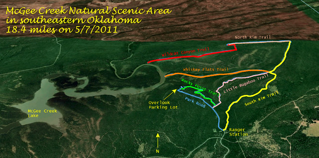
Bartlesville has only grown to 36,000 as of the 2010 census and still has that small town feel. But I’ve grown to like the advantages of living in a town small enough that you can easily grasp what is going on and even play a meaningful part in town life. In my case I’m extensively involved in school district planning thanks to my track record of achievement, elected office in the teacher’s union, and the openness of our administration. I don’t want to disappear into a big city and in recent years I’ve switched my Saturdays from Tulsa trips to hiking treks. While that certainly has not saved me any gas and it means I see friends in Tulsa less often, it keeps me in better physical and mental shape to spend hours walking in the great outdoors rather than strolling idly through Tulsa’s shopping malls.

Almost 2/3 of the people in our region north of Tulsa have what I consider a long commute

I certainly prefer living here to living in Owasso, although the latter is growing madly thanks to its close proximity to Tulsa and boasts better dining and shopping. Mind you, I don’t cook to any meaningful extent, so restaurant dining is a big deal to me. I see how ConocoPhillips folks moving up from Houston sometimes live in Owasso and gladly suffer what seems to them a minor commute. But I’d hate living in Owasso because, like so many bedroom communities around big cities, it lacks a soul. There is no “there” there; it feels like a strip-mall and big-box store shopping district surrounded by houses, lacking the central downtown Bartlesville has with its large corporate towers, Community Center, and historic structures. I like living in a place with some history.

One reason Bartlesville has not grown much in 20+ years is that Phillips Petroleum was the big employer in town and it kept downsizing the local operations until finally merging with Conoco in 2002. The city managed to hold its own, diversifying with smaller employers, but the merger a decade ago shifted many high-income and highly educated executives and engineers to Houston when the refining, wholesale marketing, and exploration and production divisions shifted way down south. Up here we now have more accountants, human resources, and information technology folks, although thus far we still have the research center and that certainly provides community support for my field of science education.

17.5% of the folks in Washington County are 65+

But over the past decade the typical Bartian has become older and poorer. I’ve always noticed how many more retirees and fewer college-age people there are in Bartlesville because we only have a couple of small institutions of higher education. But the United Way data quantifies that in Washington County 17.5% of the population is 65+ while the percentage in Tulsa County is only 12.1%.

Oklahoma is losing young adults

Overall, Oklahoma is shedding folks who are between 34 and 47, and this cripples our economic power and tax revenues. Hence the importance of the young professionals groups here and in Tulsa who seek to improve the environment for their peers and thus staunch the flow, helping young adults have a happier stay in our state so they remain with us as they mature into their late thirties and early forties.

The students in the corridors at the school where I teach are also noticeably poorer in dress, language, and behavior, showing the impact of increasing poverty and broken homes. I have fewer students in physics than ever before and a smaller percentage of my student are attending selective universities.

Over half the elementary school children in Bartlesville qualify for a free or reduced lunch

One clear indicator at school of poverty levels is the number of students who qualify for a free-or-reduced lunch. The rate has more than doubled in our district since I came here. Now over half of our elementary school students qualify.

Fewer people are married

The United Way’s profile shows the changes in the homes those children grow up in. The percentage of folks in Washington County who were 15 years or older and married plummeted from 62% in 2000 to 55% in 2009. I’m part of the problem, of course: my “never married” group has risen from 18% to 23% in that time.

Typical families vary by race

But I don’t have any children, and it is interesting to note how children of different races often grow up in very different families. Notice how much more likely an Asian American child in Washington County is to grow up in a married household (85%) than an African American child (51%), with over 40% of African American children growing up in a household headed by a female. But Hispanic families fall into almost identical category percentages as Caucasians.

Female-headed households are way up

Overall, the percentage of households with children headed by only a female has exploded since I came to town, rising from 14% to 24%.

More teenagers are giving birth

The percentage of teenagers giving birth in Washington County rose from 10% in 1980 to 15% in 2008.

When I was in high school, having a child out of wedlock and teen pregnancy were shameful occurrences. There’s a reason the term bastard became a pejorative – the value society placed on wedlock for a child’s upbringing (and for legal inheritances). That stigma is fading, but so is that of teen pregnancy. Some single teenage mothers celebrate their pregnancy and their babies, even though the statistics on the future for them and their children are horrifying.

There are more and more single moms

In Washington County, the percentage of women giving birth who were single has risen from 6% in 1980 to 38% in 2008. Egads!

Look at the median income for female-headed households

Take a look at the very low income level for female-headed households.

The middle class is shrinking at both ends

Across our nation the era after World War II saw the immense growth of the middle class, but we are now in a long-term trend where the middle class is shrinking and the gap keeps growing between the very rich and the very poor.

Bartlesville, a city of workers

The Great Recession we have lived through in recent years is shown in rising unemployment here in Bartlesville, but happily the overall rate remains low and has not even reached the rates we saw in the recession of the early 1990s.

1/3 of Oklahoma are obese

One thing I find particularly striking is how fat Oklahomans have become. When I hike in Colorado or hike or walk city streets in the Pacific Northwest, people are much thinner and healthier. Our whole culture is eating improperly and not getting enough exercise, but Oklahomans are worse off in part due to their poverty. The poor buy cheap processed food which is less nutritious and higher in calories, and easier to prepare, than more expensive fruits and vegetables and the various ingredients needed for healthier cooking, which also takes more time and is a greater relative burden for the stressed-out working poor.

I still like living here in Bartlesville, which continues to win awards as a great low-cost place to live with a good quality of life compared to many other places in our region. But the trends are worrisome. These problems are not insurmountable, but they are not going to be addressed when our state’s voters elect politicians who keep cutting not only taxes but also overburdened state services. Oklahomans have done more with less for years, but there is a limit.

Posted in politics, random, web link | 11 Comments