Waterfalls: Day 6 of the Oregon Trails

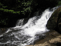
Alsea Falls (click for slideshow)

Alsea Falls (click for slideshow)

I woke up today and had a hearty breakfast at the Agate Beach Inn’s Starfish Grill.  Lots of driving today, since I headed over 70 miles inland to visit Alsea Falls and Green Peak Falls.

I drove east on Highway 20 until I reached Burnt Woods and, despite that fearsome name, turned off onto forest roads towards Mary’s Peak, the highest peak in the Oregon Coast Range.  I saw almost no one for miles, making me a tad nervous as Trixie, my V7 GPS navigatrix, guided me from one gravel road to another.  But the mountains gave Trixie fits and I hadn’t brought my Oregon Gazetteer (cursed airlines and their luggage weight limits), so I wound up on the wrong side of the peak facing a signpost that warned me I was on corporate land (as if I couldn’t tell from all of the ugly clear cuts) and could not continue without permission.  Being a good little boy, I retreated, muttering to myself that it was too cloudy for good views anyway.  At best I was being respectful of property ownership, but in fact it was a failure of courage.  There was no phone service out there, but later I reconstructed my wanderings with Google Maps.

Trixie steered me onto the Tum Tum Road, which reminded me that it was approaching lunchtime.  So I drove back onto Highway 20, past Philomath and into Corvallis.  My breakfast had been so large and late that I wasn’t all that hungry, so I used Yelp to steer me to Le Patissier, a French bakery owned by Didier and Trinidad Tholognat.  With names like that and my only French being a week of instruction in the fifth grade, I wasn’t surprised that I could barely decipher what was on offer.  But the Pain Au Chocolat in the display case beckoned and I was relieved to discover that it was a variant of the croissant with a chocolate strip in the middle.  I’d navigated to Yum Yum Road.

I drove on to the true goal for the day, the Alsea Falls Recreation Area.  This is a remote location with few signs and several wild drivers with the Bureau of Land Management who careened by me on the curves in their pickups.  What with my Hawaiian car license tags I’ve been saying “Aloha!” to other drivers, but with these guys all I could manage was “Whoa!” before they disappeared into the dust.

Alsea Falls drops perhaps 100 feet along the south fork of the Alsea River, although that is broken up into multiple smaller falls at this time of year with swimmers taking advantage of the reduced flow.  I took a shot of the upper falls and then went downstream where I could move out into the flow, courtesy of my waterproof hiking shoes, for a snapshot or two and a panorama.

I hiked about five miles around the area, including up along Peak Creek to Green Peak Falls, which drop about 50 feet.  A couple and their dog were out in the middle of the downstream flow from Green Peak Falls, so I followed their lead although I missed my trekking poles.  I’d left them in the car since the trail was so gentle.  Feeling pleased that my shoes were still keeping me dry, I promptly slipped on a mossy rock and fully immersed both shoes in Peak Creek.  My SmartWool Light Hiking Socks, thinking I was suddenly sweating profusely, attempted to sop up the entire creek.  They failed, but I got the shot.

I squished my way back to the car, where I changed my shoes, socks, and shirt.  Trixie urged me to go back to the coast via “Alsea Deadwood Highway” and “Lobster Creek Road” and “Unnamed Road” and the like through the Cummins Creek Wilderness of the Siuslaw National Forest.  But, tired of forest roads of dubious quality, I insisted we backtrack to Monroe and take state highways from there.

Highway 36 spun me right round, baby, right round like a record, baby, right round round round.  My apologies to Ratt, but 36 was a bit tedious as it wound its way slowly toward the coast with hardly another car in sight.  I was glad to finally hit 126 where the road improved (and of course the traffic increased) as it paralleled the Siuslaw River to the coast.

Highway 101 rides the coastal cliffs from Florence north to Yachats.  One magnificent mile upon another flew by and I passed Cape Perpetua, which I visited briefly in 2006 and will be hiking all day tomorrow.  North of Yachats I reached the Fireside Motel, where I had reserved a room for two nights.  This was the only reservation I couldn’t fully complete online, so I wondered what I’d find.

Only the best room with a view on the trip, I dare say.  I’m sitting here in my room a few feet from the ocean next to a big window that looks directly out on the Pacific.  I’m leaving the drapes open tonight so that I see the ocean first thing when I wake up in the morning.  Well, after I put on my glasses.  Sigh.

Yelp tried to lead me to the Drift Inn for dinner, but there was nary a parking space to be had there.  So I drove to Le Roy’s Blue Whale, where I had a serviceable fish and chips and a slice of chocolate cream pie.  Now it is dark, I am tired, and you have a slideshow of photos and even a movie of the waterfalls to view.  Enjoy!

[Next post: Cape Perpetua and Smelt Sands: Day 7 of the Oregon Trails]

Didier and Trinidad Tholognat
Posted in day hike, travel | 1 Comment

Cascade Head and Newport: Day 5 of the Oregon Trails

Yaquina Head Lighthouse (click for slideshow)

Yaquina Head Lighthouse (click for slideshow)

I loved this road sign at the Cascade Head trail today, for I did indeed have pedestrain by the time I finished hiking 6.2 miles and going up and down 1200 feet.

The day began with a ho-hum breakfast at the Pig ‘N Pancake at Lincoln City…nice building, but the food was nothing special.  But Motel 6 doesn’t offer continental breakfast, so whatcha gonna do?  It was chilly and foggy today, which didn’t bode well for the views on my hike.

I drove north a few miles to the Nature Conservancy’s Cascade Head area which they preserve for some butterflies as well as hiking enjoyment.  The trail was an interesting mix of forest and grassland with what on a clear day would be a spectacular view of the Salmon River and Lincoln City down below.  But today I could only snap a cloudy shot of the river from the trail well below the summit, although the panorama was still impressive.

After that, my ascent was fog-bound and the views were non-existent.  But I still enjoyed reaching the summit, snapping some of the plant and animal life, and happily the trail then re-entered the forest and was quite beautiful.  I refrained from listening to my iPod on the ascent, enjoying the sounds of the ocean and the grassland.  But for the long descent I indulged in some more fun lectures by OU’s Professor Rufus Fears courtesy of the Teaching Company.  I met him back in 2004 when he won the Oklahoma Medal for Excellence in university teaching while I received the one for secondary teaching and since then have enjoyed many of his wonderful lectures on great books, history, and classical Greece and Rome.

By one o’clock I was back at the car and truly weary.  So I drove into town and had a memorably bad French dip sandwich at McMeniman’s Brewpub.  Yelp.com did me wrong this time!  ‘Twas a dry sandwich, which the incredibly salty au jus could not put right.  Their decision to call it an “American” dip should have warned me off, for Americans do love salt.  I was on the upper floor of the restaurant where one poor waitress struggled to service too many tables, both indoors and outdoors, dragging food up from the floor below.  But the part that bothered me most was how the floor and table shook every time anyone walked by – I prefer my meals without tremors.

I then drove south to Newport and took in the Oregon Coast Aquarium.  Nothing new – I’ve been to so many aquariums I can predict all of the exhibits by now.  But I did take some cursory shots of a pigeon guillemot and tufted puffin in the aviary and a sea otter.

I checked into the Best Western’s Agate Beach Inn, which I recalled from 2006 had a lovely view of Yaquina Head.  Today the view is misty, but as I write my room’s window wall’s sliding glass door is open so I can hear the ocean and see the Yaquina Head lighthouse beacon pulsing through the dusky air.

Dinner was at Izzy’s smorgasbord, so I cobbled together salad, corn, peas, green beans, and other sautéed vegetables with a bit of fried chicken, a tiny slice of mushroom pizza, and dessert.  Methinks I was overcompensating for lunch.

It was still light, so I paid the day use fee to revisit Yaquina Head, which I toured extensively in 2006.  I had left my usual camera in the hotel room, so I snapped not one, not two, not three, but four different odd shots of the lighthouse using some of the iPhone filters.

Then it was back to the hotel for a dip in the pool to relax and then today’s blog posting and slideshow.

I’ll try to sleep in tomorrow, although I note that 12 people just filed into the room next door and they are suitably noisy.  Egad, I hope they will disperse to other rooms or that will be one crowded bed!  Sounds like a night for ear plugs and Ambien.

The plan for tomorrow is to take a scenic drive inland two hours to hike at Alsea and Green Leaf Falls (if my poor feet don’t rebel), then drive back out to Yachats on the coast for the night.

[Next post: Waterfalls : Day 6 of the Oregon Trails]

Posted in day hike, travel | 2 Comments

Neahkahnie Mountain and Two Haystacks: Day 4 of the Oregon Trails

Atop Neahkahnie Mountain (click for slideshow)

Atop Neahkahnie Mountain (click for slideshow)

After another continental breakfast, I checked out of the Microtel and drove south.  I made a brief stop at Cannon Beach to photograph their Haystack Rock, which is 235 feet high and proclaimed the world’s third largest coastal monolith.  However, later in the day I would photograph another Haystack Rock at Pacific City, and that one is 100 feet higher, but is not proclaimed as the first or second largest coastal monolith.  Perhaps they went by volume, or it’s all tourist twaddle.

From there I drove down Highway 101 to Neahkahnie Mountain.  Rising 1634 feet above sea level, the mountain features a trail with a 700 foot elevation gain over a 1.5 mile hike and rewards the climber with a spectacular view south over the coastal town of Manzanita.

After traveling along a rough gravel road a mile or two off Highway 101 I reached the trailhead.  A group of bicyclist adventurers were there for the ascent, although they had to hoof it rather than pedal it.  The main trail wraps around a ways below the summit, but my handy Hiking the Oregon Coast
book told me about a very steep and rocky side trail that went to the summit.

The view from the top was as spectacular as promised, and one of the bicyclists was kind enough to take a photo of me at the summit.  I had to descend the way I came up to reach my car, whereas the bicyclists were able to go on down the other side of the mountain where their van would be waiting.

I then drove in to Manzanita to catch a glimpse of it from ground level and thought about grabbing lunch, but several restaurants were closed on Monday in this tourist town.  So I drove on down Highway 101 to the Tillamook Cheese Factory.  There were scads of people there!  I can only imagine the madhouse it must have been over the weekend.

I ordered the “Centennial Grilled Cheese Sandwich” with fresh cheese from the factory and honoring the founding of the area dairy farmer cooperative in 1909, which has grown to 110 farms.  The wait was 30 minutes and for most of that there were no free tables in the place.  But one finally opened up and I welcomed two other fellows who were also waiting for a table.  My sandwich came with a good salad, but they forgot the dressing.  No doubt a misguided effort by the waitress to make the lunch a tad healthier.

One of my lunch companions was a fellow from Portland who was the caretaker for the other older gentleman, who had a speech impediment and other handicaps from some past accident.  Revealing I was from Oklahoma prompted the man being cared for to reveal he had previously lived in Nebraska and Missouri before his accident.  When I mentioned enjoying the Ozark lakes, he said he used to do some slalom water skiing there.  So I’m certain he was grievously injured when he fell off a single ski at high speed.  Note that if he claimed otherwise, I would naturally ignore his protests.  No dirty little facts should get in the way of my beautiful theory.

Bidding my table companions farewell, I headed to the ice cream counter, a primary draw at the factory, for a delicious treat.  Then, deciding to further enrich the cooperative, I bought a T-shirt proclaiming my love for the Oregon coast.

It was a short drive on into Tillamook where I turned off Highway 101 onto the Three Capes Scenic Drive, which hugs the coast.  The first part west out of Tillamook is the best since it literally runs along the shore, with the ocean a few feet below the edge of the road.  Later one reaches Cape Meares, which I visited in 2006 and skipped today since it was cloudy along that stretch of the ocean.

My progress along the Three Capes drive was greatly slowed by paint trucks as they worked on the roadway’s center stripes and shoulder lines.  I followed the white striper for so long that I began to worry some paint spray might be coating the rental Saturn, but a later inspection laid that to rest.  But it did point out how dirty the car had become, so I ran it through a car wash when I filled up in Lincoln City.  Well, to be accurate, someone else filled it up.  Oregon doesn’t allow you to fill your own car – you have to let an attendant take care of it, although since 2001 motorcyclists have been allowed to fill their own tanks.  Go figure.

After passing Cape Lookout, I decided to drive out onto another sand spit, the Bob Straub State Park at Pacific City, which occupies the Nestucca sand spit.  So the beach is a huge expanse of sand bounded on the north by the taller Haystack Rock.  The park has trails and I briefly tried one.  But while I don’t mind climbing short mountains and hiking 13 miles along the coast, I am utterly defeated by a trail made of sand.  It was such a slog that I soon realized there were better ways to spend my time.

Which brings me to winning $8 off the Siletz Indians.  My day ended in Lincoln City, where I had a nice halibut dinner with salad at the Dory Cove restaurant.  Then I wandered through the Chinook Winds Casino, operated by the aforementioned Indians.  I avoid casinos for the most part, but decided to try some “nickel slots” and when I finally received a $20 payout on a 20 cent bet, putting me $8 ahead, I cashed out.  And promptly spent 1/4 of my net winnings at the Motel 6 vending machines.  Easy come, easy go.

So another day ends with this blog entry and today’s slideshow.   Tomorrow I’ll hike some of the trails at Cascade Head.

[Next post: Cascade Head and Newport: Day 5 of the Oregon Trails]

Posted in day hike, travel | 2 Comments

The Oregon Coast Trail: Day 3 of the Oregon Trails

Hiking the Oregon Coast Trail (click for slideshow)

Hiking the Oregon Coast Trail (click for slideshow)

I slept in today, recovering from the strenuous hike up Saddle Mountain yesterday.  After a continental breakfast at the Microtel I finally drove south to Ecola State Park and arrived at the trailhead at Ecola Point at 10 am.

I decided to hike the coast today, thinking it might be a flat relief from the mountain, but that was not the case.  I did about 13 miles of trail today, and all of it was up and down, clambering up about 600 feet on Tillamook Head along the Oregon Coast Trail.  This part of the Oregon Coast Trail was originally used by the Clatsop and Tillamook Indians, and during Lewis and Clark’s winter stay in the area Clark came along here from Fort Clatsop up north to see a beached whale at one of the creeks.

Beginning at Ecola Point, I hiked 1.5 miles north to Indian Beach.  I’d been here back in 2006, when I did a late afternoon hike partway along the Clatsop Trail until dusk.  I caught a nice shot of Ecola Point with the moon overhead back then.

Today I took a gravel service road on north from Indian Point over toward the Tillamook Lighthouse, and then rejoined the Oregon Coast Trail that wound up and around Bald Mountain and Clark’s Mountain towards Seaside.  Along the way I passed through the hiker’s camp for backpackers, where I also came across an abandoned radar station from World War II.

The trail wasn’t as well maintained on north beyond the hiker’s camp, with lots of muddy sections.  I had taken one trekking pole along, and that helped me navigate the muddy trail, although I do have some muddy jean cuffs.

There were some nice viewpoints looking out to Tillamook Rock Lighthouse, which is now a columbarium (storage for cremain urns).  This was a desolate and storm-tossed posting in its day, with a storm in 1896 tossing a 135-pound boulder through the roof into the kitchen!

After hoofing it over six miles toward Seaside, I found a rock where I could sit down for a snack on the trail and then reverse course.  This time on the way back south I took the more scenic trail along the oceanside on the Clatsop Loop Trail between the hiker’s camp and Indian Beach.

It was interesting to see how different the Indian Beach area and the natural arch at Ecola Point appeared at 10 am and then later around 5 pm.  But after 7 hours of hiking along 13 miles of coastal trail, I was hungry and my feet were beginning to really ache.

So I drove back to the Microtel for a shower and then drove into Seaside for a  big tasty lasagna and salad at Guido and Vito’s Italian Cuisine, followed up with a single dip of chocolate mint ice cream at the Dreyer’s shop.  Then it was back to the Microtel to blog, prepare today’s slideshow, and rest my weary hooves.

Tomorrow I plan to drive south and hike up Neahkahnie Mountain for what are promised to be spectacular ocean views if the “partly cloudy” forecast isn’t a spoiler, and then mosey on down the coast past Tillamook (where I visited the cheese factory and air museum back in 2006) to the Motel 6 in Lincoln City.

[Next post: Neahkahnie Mountain and Two Haystacks: Day 4 of the Oregon Trails]

Posted in day hike, travel | 1 Comment

Garden, Trail, and Sea: Day 2 of the Oregon Trails

Day 2 in Oregon (click for slideshow)

Day 2 in Oregon (click for slideshow)

Day two of this Oregon trip started an hour later than usual for me, but that was 5 am Pacific.  You see, my circadian rhythm is still on Central Time, so to me I slept in an hour and woke at 7 am Central.  So if I do the same tomorrow I should be back in sync – right?  Er…

At 5 am on a Saturday one has some time to kill, so I asked Yelp.com where I should get breakfast.  It recommended the nearby Cadillac Cafe and its delicious hazelnut French toast plus egg and bacon.  Yummy to the tummy!

When dressing I had realized that I forgot a belt for my cooler seashore hikes, so I decided to visit Jasper Johns (Target for the uninitiated) to prevent a wardrobe malfunction.  While there I picked up some cheap bottled water for my day hikes.  Deciding to skip the interstate, I instead drove city streets along the flanks of Mount Tabor, the extinct volcano perched in northeast Portland.

Today I took full advantage of my friend Betty Bio’s help.  She had said the Japanese Garden over in Portland’s Washington Park was superb.  So from Jasper’s I drove down to the Willamette River, crossed over into downtown, and then climbed the heights overlooking Portland from the west.  And the garden did indeed affect me – I was snapping photos like the stereotypical Japanese tourist.

After so much peaceful contemplation, I balanced the day by hitting the highway toward the seashore, which was packed with Portland citizens fleeing the city.  By early afternoon I reached the Camp 18 restaurant near Elsie, lunching in its large timber frame dining hall.  Since I had French toast for breakfast, it seemed appropriate to have a French dip and French fries for lunch.  Two of the waitresses admired my new Escher tattoo – pity it will wear off soon.  Then it was a short drive on to the Saddle Mountain turnoff.

Seven slow miles along a narrow and rather dippy forest road brought me to the trailhead.  Saddle Mountain takes the prize as the most strenuous hike on my agenda: 1623 feet of elevation gain in about 2.6 miles of trail.  They’ve made lots of trail improvements to help – long stretches have fencing pegged on the trail to hold the rocks, prevent erosion, and give you some grip.  Other sections are built up with rocks, there are a few cable rails, and more.  All of which are needed!  It was a long, steep climb, reminding me of my 2006 trip to Oregon when I clambered up and down the side of Crater Lake and up and down Multnomah Falls.  I tried not to think too much about gravitational potential energy, but it was a struggle.

Unfortunately the summit was in clouds by the time I made it up there, but it was still fun to feel like we hikers were on the edge of an abyss.  I took a very narrow side trail from the summit over to a rocky promontory, discovering a fellow hiker had left a tiny American flag at the end for fellow adventurers.  Cold winds began to blow across that rocky point jutting out into the clouds, and I made an Audioboo from there to capture the moment.

Remember I said I had Betty Bio’s long-distance help today?  On my many past day hikes I’ve always just made do with tennis shoes and a tiny backpack, but she insisted on buying me hiking shoes and trekking poles for my birthday for this trip.  Saddle Mountain proved her case: the boots made me more sure-footed and the trekking poles allowed me to use my arms to help me clamber up the many steep trail segments.  And on the descent my reliance on the poles left me feeling like a mildly retarded mountain goat.  I won’t need the poles on my seaside hike tomorrow, but they were a godsend on Saddle Mountain.

After hours climbing up and down some of the steepest trail segments I’ve encountered I longed for the flat beach.  So I drove on down to Seaside and checked in and showered at the Microtel.  Never been in one of these before.  The rooms are indeed smaller than usual, but are well-designed and appointed.  I liked it better than the Motel 6 in Portland, although that stay was quite tolerable.  More Microtel and Motel 6 stays to come on this trip, although a couple of nicer hotels are coming up soon.

For dinner I drove downtown with its tourist shops and many noisy motorcycles in town for the weekend.  The crowds convinced me to take a side street to a nice little pizza joint, and Italy is next door to France, after all.  I followed that up with some tasty mint chocolate chip ice cream from the strip.  Eating junk food may be my subconscious attempt to compensate for all of the exercise!

I took a final short walk over to the ocean to say hello to the water and goodbye to the sun.  My camera had run out of storage space, but I had fun using my iPhone’s photo filters for the odd shot or two.

I’m uploading photos tonight for the latest slideshow, but will skip editing the various video clips for another time.  Tomorrow I plan to hike the Oregon Coast Trail above the beach all day – if my energy and body hold up I might walk the 6.5 miles from Ecola Point back up here to Seaside for lunch and then back in the afternoon to Ecola Point for the car.  13 miles of flat trail sounds like a piece of cake after Saddle Mountain’s five miles today.

[Next post: The Oregon Coast Trail: Day 3 of the Oregon Trails]

Posted in day hike, travel | 3 Comments