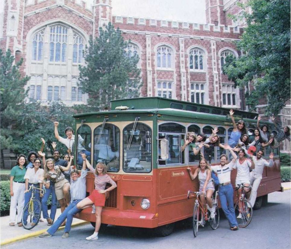
My only regular rides on a “trolley” were as an undergraduate at the University of Oklahoma, which began running the Boomerville “trolley” in 1980. It was made to resemble an old-fashioned trolley, complete with wooden interior seats, but ran around campus on rubber tires, not tracks, and was propelled by an internal combustion engine. There were a few of that style of trolley in the university’s system while I was there from 1984-1988, but they soon added regular coach buses, which I greatly preferred. They had far more comfortable seats and were air conditioned.
The University of Oklahoma started running the Boomerville “trolley” in 1980
I have ridden one actual trolley, the Saint Charles Streetcar Line in New Orleans, which is the oldest continuously operating streetcar line in the world. I’ve seen the Old 300 trolley along the Columbia River in Astoria, Oregon. But I’ve never been to San Francisco, so I have not experienced its famous cable cars.
Real trolleys were once commonplace. Oklahoma City had an extensive system from 1903 to 1947, including interurban lines that stretched north to Guthrie, south to Norman, and west to El Reno. Oklahoma City brought streetcars back in 2018 on new tracks that make a couple of loops downtown, but if you want to experience a historic trolley, you need to go west to El Reno, where the Heritage Express Trolley runs a 1924 car on a 1.5-mile loop.
Tulsa once had three electric railway companies, with service starting in 1906 and peaking in 1923 with 21 miles of rails. An interurban ran to Sand Springs until 1955 and to Sapulpa until 1960.
I’ve posted here before about some of the remains of the interurban one can spot along the Pathfinder Parkway near Robinwood Park, and there is still a diagonal Interurban Drive northeast of the park that follows part of the old route that once led past the unincorporated Tuxedo community as it headed north to Dewey.
My father was born in Dewey several years after the interurban folded. But he still got to ride an interurban trolley in the years before World War II, because his family moved north to rural Kansas.
My grandfather had left farming in southwest Missouri in 1923, bringing his family to Dewey in a covered wagon pulled by a team of horses. His brother-in-law, Enoch Weston, was working as a power plant operator at the Dewey Portland Cement Company, and my grandfather hoped to land a job there.
After a considerable wait, he was hired at Dewey Portland, starting out in the foundry and later becoming a machinist in the plant’s machine shop. In 1936, my grandfather got a job as a machinist for the Cities Service Gas Company. Although Cities Service was headquartered in Bartlesville, and would not leave it until 1968, the job site was an isolated compressor station up in Kansas.
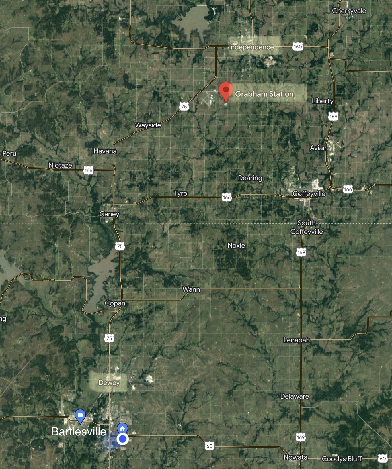
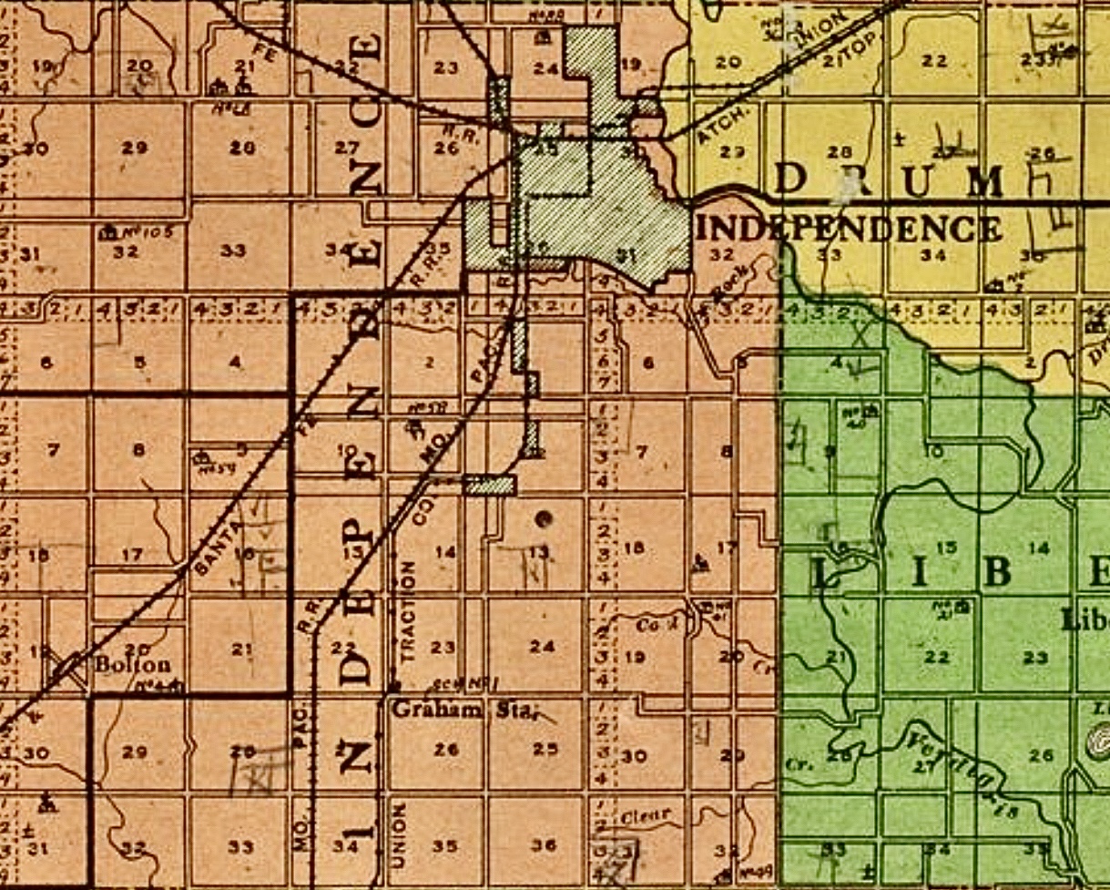
Map to help you locate Bartlesville and Dewey in Oklahoma and Grabham Station and Independence up in Kansas
The family moved 27 miles northwest as the crow flies, and maybe 35-40 miles by road, to Grabham Station about five miles southwest of Independence. Dewey was a small town, small enough that the Meadors once packed into their Studebaker Erskine on Saturday nights to drive four miles to Bartlesville to shop and people watch. But Grabham Station wasn’t even a town.
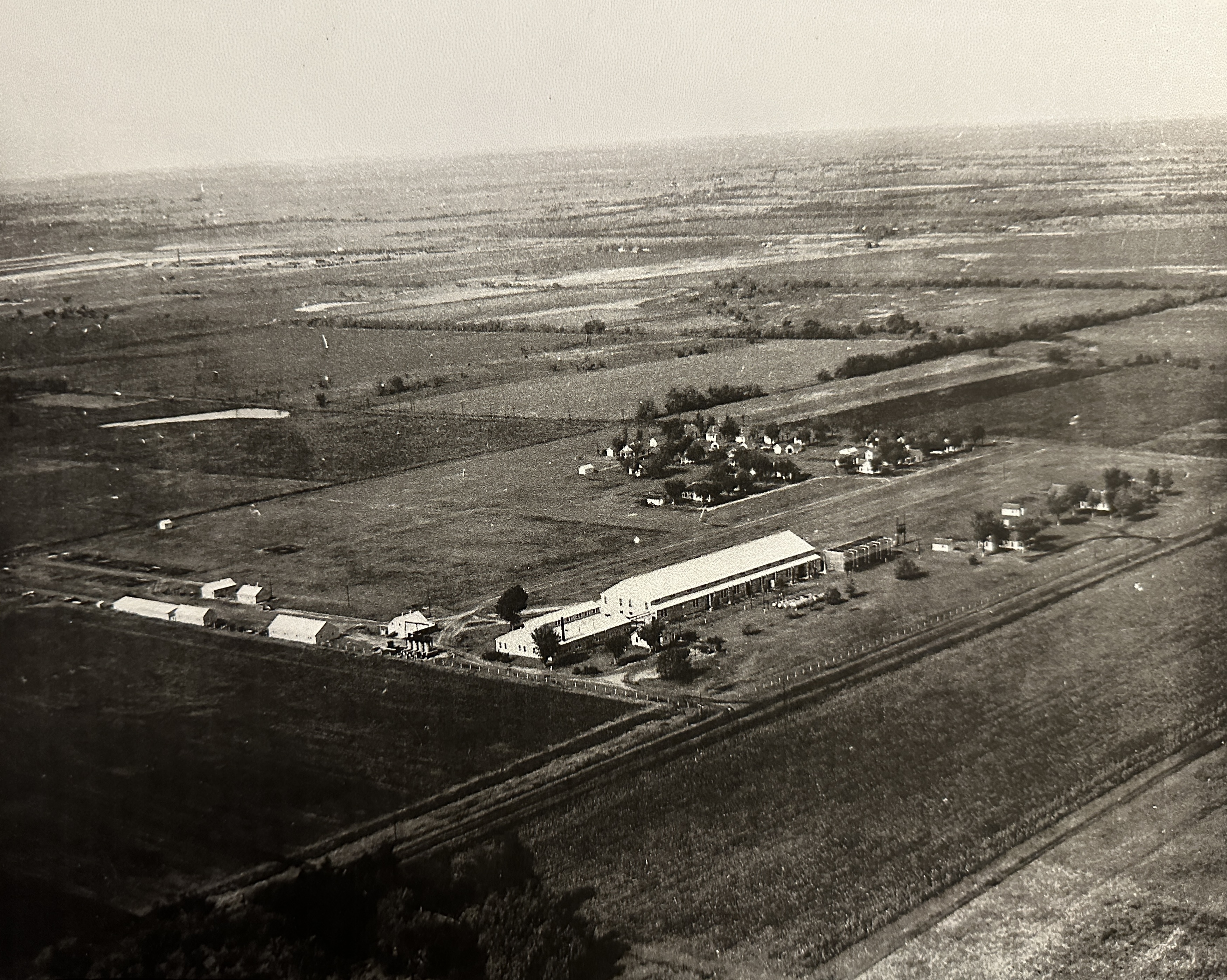
Grabham Station, where my father lived from 1936 to 1943
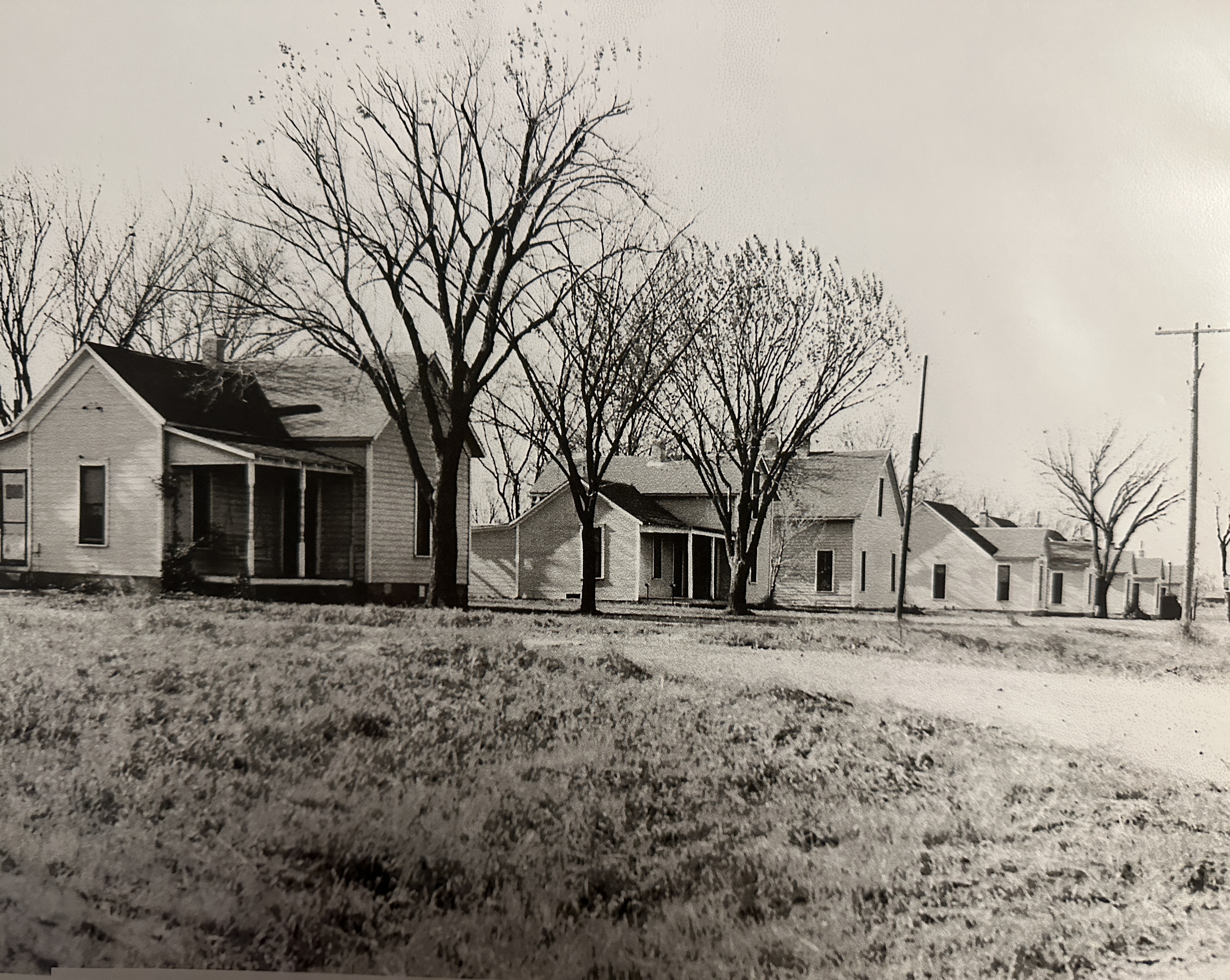
The station compressed natural gas to send it down pipelines to various cities and industries. A pipeline division was stationed there, along with a pipe yard and welding shop. There were about 20 company houses at the station, which employees rented at a modest rate of about $2 per room per month.
Company houses at the Cities Service Gas Company’s Grabham Station
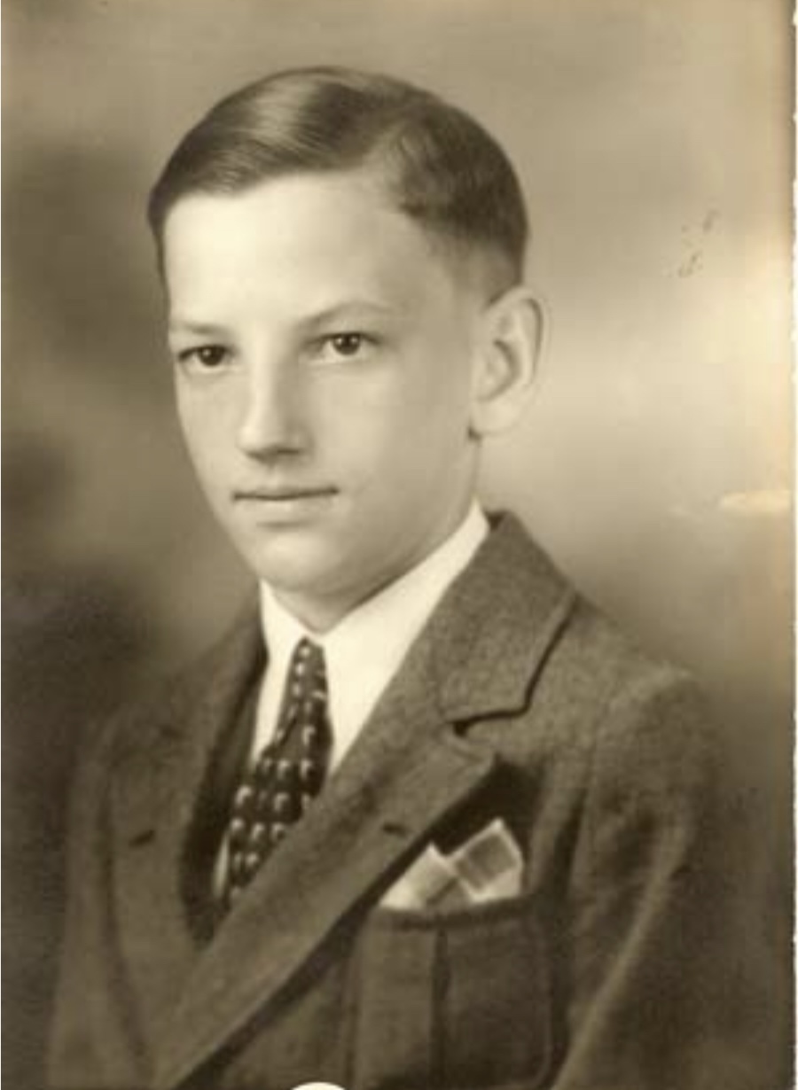
My father’s 8th grade graduation photo in his first suit
I got to know those old houses pretty well, since when he retired, my grandfather purchased two of them and moved them nearer to town and Independence Community College. Those houses were where my grandparents and one pair of my aunts and uncles lived when I was a kid.
My father attended 7th and 8th grades at the Maple Grove one-room schoolhouse about a quarter-mile from the station. As you might guess from the above photos, Dad said there sure wasn’t any grove of maple trees around the school when he attended.
Dad was a pretty smart cookie, being named the 8th grade salutatorian among the 176 rural school 8th graders in Montgomery County. He posed for his 8th grade graduation photo in his first suit.
More to the point for this post, his graduation meant that it was time for him to leave the one-room schoolhouse for high school in Independence.
He could have ridden his bicycle, as he often did in good weather for the quarter-mile to Maple Grove. But to reach Independence, he would have to travel two miles east on a gravel road to then take the paved 10th Street five miles north into town. He only did that a few times, since it was far easier to ride the interurban.
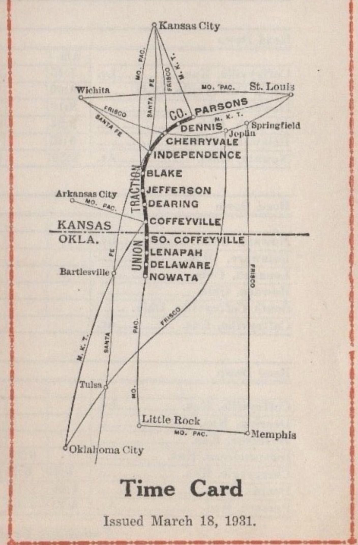
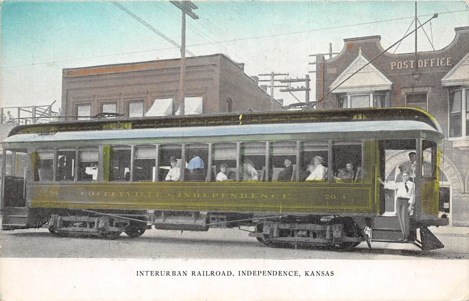
The Kansas interurban my father rode; Grabham Station was just south of Blake
The Union Traction Company was created in 1904 and initially linked Coffeyville, Independence, and Cherryvale, Kansas. By the 1930s it had grown to reach 88 miles from Parsons in the north down to Nowata in Oklahoma. It ran right past Grabham Station, and remained in operation until 1947.
The “Union Traction Co.” is the interurban trolley line, running east of the Missouri Pacific Railroad; this old map misspelled Grabham Station as “Graham”; I recently noticed Google Maps had the same mistake, which I corrected
My father wrote:
The rural kids that rode this electric trolley were pretty rowdy at times. A small portion at the rear of the car was closed off from the rest of the car. This rear section was called the “smoker” because that was where smoking was allowed. Isolated as it was from the motorman, it became a favorite area for the “wild bunch” to gather. There was lots of cutting up and loud noise back there. A favorite trick to pull on the motorman was for several boys to get off at one stop and, as the trolley pulled away, one of the boys would run behind the trolley and pull down the mast that rode the hot wire above the car. This disconnected the electric power to the car and stranded it. The poor motorman would have to get out and re‐engage the power mast before the car could move on down the track. Of course the boys would have scattered by then and the poor motorman would not be able to tell which one was the culprit. Don’t you know it took a lot of patience to be a motorman?
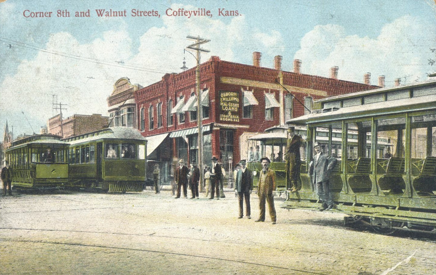
The interurban intersects the city streetcars in Coffeyville; the interurbans were larger and had low grills to protect their wheels
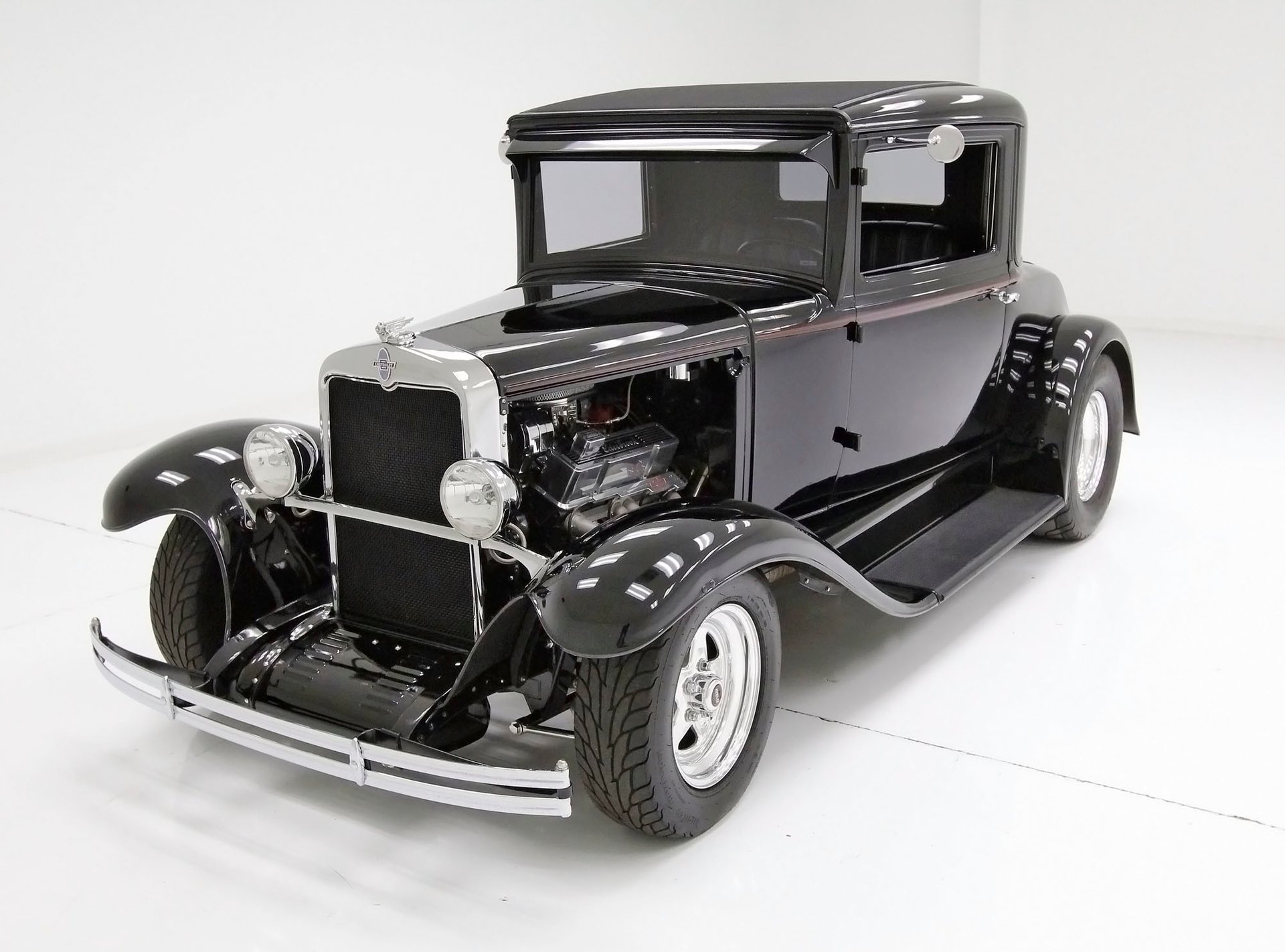
Dad would ride the interurban throughout high school, including for jobs at a couple of grocery stores and a year of junior college, until he was inducted into the U.S. Army in 1943. After service in Denver, Europe, and the Philippines, he returned to Independence before enrolling at Kansas University in Lawrence. He didn’t own a car until he bought a 1930 Chevrolet coupe in 1946. I like a story he told about that first car:
It only ran part of the time. I say that because it had a bad habit of suddenly quitting as I was driving along. I found that by getting out and raising the hood, disconnecting the gas line from the carburetor, back blowing the line to the gas tank by using my tire pump, connecting the line back, and closing the hood, I could be on my way once more. Needless to say, when this occurred in traffic it was not only irritating but quite dangerous.
The problem was solved by my fishing a large silk or rayon rag, that had long streamers of thread along its edges, from the gas tank. The streamers had been periodically floating into the opening to the gas line and stopping the flow of gas to the motor. Problem solved!
Later a valve broke off and exited through the side of the engine block. My father haggled with a shade tree mechanic to replace the valve and braze shut the hole for $35, which he said made the car worth at least $45 at that point! He ended up borrowing $435 from his father to buy a 1929 Ford Model A coupe that served him better for a couple of years.
Despite the hassles of owning and maintaining an automobile, the shift from streetcars to private automobiles was commonplace, with few trolleys surviving for long after World War II. We tend to romanticize trolleys, but most towns are now designed around the automobile, ensuring its continued dominance. Streetcars are now just a rare novelty, and interurbans a distant memory.
Buzz, buzz, buzz went the buzzer Plop, plop, plop went the wheels Stop, stop, stop went my heart strings As he started to leave I took hold of his sleeve with my hand And as if it were planned He stayed on with me and it was grand just to stand With his hand holding mine to the end of the line.
On most recent Wednesday evenings I have shared on my Facebook profile some remembrance from the past. After dutifully applying the #grangerthings and #ThrowbackThursday hashtags, I decide whether a post should be public or instead restricted to my over 1,900 friends on that social media platform. That’s a Hobson’s choice, of course, since once you post anythinganywhere on the internet, you should consider it public. Yet sometimes I apply the restriction as a sort of modesty panel which any of my Facebook friends can flip up with a screenshot.
Mining My Past
For months, I’ve been mining remembrances from the old photograph albums that came to me in April 2022 after my father died and my mother moved from Oklahoma City to an independent living facility here in Bartlesville. It wasn’t practical to plant a huge bookcase packed with photo albums, genealogy notebooks, and the like in her apartment, so it landed in my bedroom.
My father’s silent standard 8mm movie camera and projector he purchased in 1961
It took some digging to free my car from the big snow of Christmas 2009 in Oklahoma City
While scrounging for another photo that could prompt a little story from the past, I glanced up at the film reels on the top shelf and remembered something. I visited my folks in Oklahoma City over Christmas in 2009, and a big snow trapped me there for several days until I could dig out.
A few days after Christmas, we were looking for some entertainment. I set up my father’s old projector in their living room, aimed my digital camera at the screen, and we spent a few hours watching the old home movies he had shot.
I captured a few clips from that, and they were stashed somewhere in my digital archive. I located them and noticed one from when I attended preschool at the First Christian Church as a three-year-old. I added some music, and voila: Preschool in 1969.
I’m the towhead in the clip, decked out in my corrective shoes and black socks. But I was a bit at a loss for a story to go with the clip. I was too young to form any lasting memories of preschool. My mother had dutifully recorded in her Our Baby book that my teacher was Mrs. Carol Koop, and that my best friend at preschool was Robbie Deaton. I figure Robbie is the kid in the matching raincoat in the clip who is trying to blow bubbles.
So my thoughts turned to First Christian itself, which was billed as the Church of Tomorrow with its striking egg-shaped sanctuary dome made of thin-shell concrete, its louvered education building, and rocket-shaped bell tower. It was completed in 1956 and was the brainchild of preacher Bill Alexander and the young architects R. Duane Conner and Fred Pojezny. Sadly, the acoustics of the dome were atrocious, and Alexander and his wife were killed in a plane crash in 1960, but his ultramodern church was still thriving when I was at preschool there in 1969.
The Church of Tomorrow
I found a photograph of one of the classrooms when the church was first opened.
Classroom at the Church of Tomorrow
Decline and Demolition
That’s where a typical #grangerthings post would end. But something rather dramatic happened at that location less than a year ago.
The end of the Church of Tomorrow came in 2022
The Church of Tomorrow campus was demolished in 2022. What killed an iconic church that had made the National Register of Historic Places in 1984? The same thing that led to the recent closure of the First Christian Church in Bartlesville.
Now, we’re venturing into religion here, so allow me to reassure you that I’m approaching this dispassionately. I am interested in trends, their symptoms, and causes. I am not at all interested in sharing my personal religious views, how they have changed over my lifetime, nor in proselytizing for or against whatever views you hold.
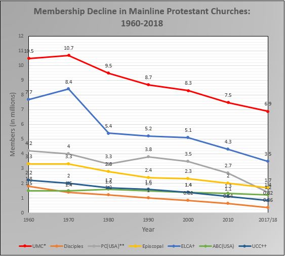
With that perspective in mind, I invite you to consider the membership timeline for the Disciples of Christ since my preschool days.
The Disciples of Christ is one of the “Seven Sisters” of what is called “mainline” protestant churches in the United States of America:
American Baptist Churches USA
Christian Church (Disciples of Christ)
The Episcopal Church
Evangelical Lutheran Church in America
Presbyterian Church (USA)
United Church of Christ
United Methodist Church
They are called “mainline” because they once had churches on most of the main streets of American towns, and when I was in preschool, almost 1/3 of my fellow Americans were members of one of them. At the time, together they outnumbered the Catholics, while less than 1/5 of my fellow Americans were in Evangelical Protestant denominations.
So were folks switching to Evangelical churches? Well, the Evangelicals did experience a surge from 1983 to 2000, fueled in part by televangelists. Their share of the population jumped from 17% in 1972 to a high of 30% in 1993. However, they had dropped to 22% by 2018.
I’ve witnessed this locally, with a growing number of non-denominational congregations even as mainline churches shrink and sometimes close. Ryan Burge is a PhD political scientist with many peer-reviewed publications and he is also a Baptist preacher. His analysis is that a shift from the mainline to non-denominational churches was once a primary factor, but now the non-denominational growth is more due to their attracting people who were raised as Catholics.
However, I must not give you the impression that we’re just seeing a shift from one form of Christianity to another. The total share of Protestants in the USA has shrunk markedly since the 1960s, dropping from around 70% to almost half that in the Gallup Polls, and there is no corresponding rise in Catholicism.
Instead, we have seen a significant rise in the religiously unaffiliated. Overall, the share of Christians in the USA has dropped from about 90% as late as 1992 to about 63% now, while the religiously unaffiliated have increased from 5% when I was a kid to almost 30% today.
Soon there will be more non-religious Americans than Evangelicals or Catholics, and many more mainline churches will disappear. As for why, there are multiple causes. Burge’s analysis is that “secularization, politics, and the internet are the major causal factors” that have given rise to the No Religion surge. He covers this in detail in his book The Nones: Where They Came From, Who They Are, and Where They Are Going.
The shift away from organized religion is most apparent in the younger generations, but all of them show the same trend in the past 15 years.
It isn’t as though a third of Americans have become atheists, however. The Nones don’t engage in religious practices, but their beliefs are diverse. Consider the responses when Americans were asked to choose among six degrees of religious belief.
So as of 2021, only 7% of the population reported themselves as atheists and another 9% as agnostics. Half the population still claimed to be true believers and another one-third still reported some degree of belief in a higher power.
Time changes everything except something within us which is always surprised by change.
Thomas Hardy
I find these sweeping changes fascinating. When I was a kid, over 40% of US adults smoked. That has plummeted to less than 14%. I am similarly surprised by how support for same-sex marriage leaped from 27% in 1996 to over 70% today. Now the USA is steadily de-churching, something that happened in Western Europe decades ago. Having been surprised by earlier sea changes, I shan’t predict the change in religious affiliations during the time I have left.
Fifty-odd years after I left its preschool, the raw red soil of my hometown is again revealed where the Church of Tomorrow once stood.
All that remains of the Church of Tomorrow is a parking lot, and…
Regardless of its causes, I instinctively view that red wound as another sinister signpost of my approaching old age. The elementary schools I attended in Warr Acres have also been razed. Time marches on, and I explore my nostalgia through my weekly remembrances, hopefully without wallowing in it.
When I captured that aerial view, I noticed that the bell tower remains at the northwest corner. So I used Google Street View to view that surviving emblem of what I once knew.
…the bell tower, now used only for cell phone antennas.
It is now just a tower for cellular antennas. How symbolic.
We arrived in Santa Fe and checked into the Casita Bonita studio guesthouse at the Santa Fe Motel & Inn. We always enjoy our stays there, although on our next visit I will try to rent the more spacious Casita Fina next door.
Dinner was from Tomasita’s just down the block at the Rail Yard, although we used Doordash so that we could relax and enjoy our food in the casita’s courtyard.
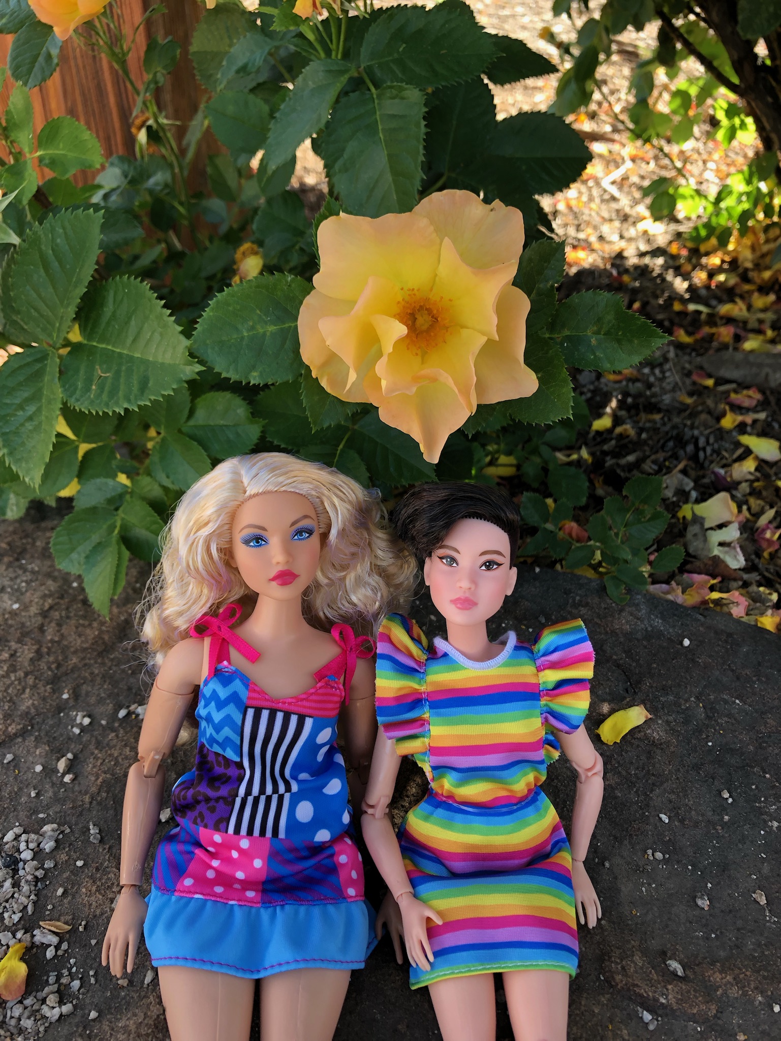
Casita Bonita
The Barbies hold our latest tile
Wendy had her Barbies pose on a chair in the courtyard, with one holding the fun tile that came with the rental.
I snapped a photo of Pueblo Feast Day by David Bradley, a 1961 graduate of the institute. It is one of a series of paintings in which he churns American culture. The Lone Ranger, a blonde with a Gucci handbag, and a member of “Heck’s Angels” were among the guests at the table in this version.
[Spanish colonists] first abducted and then later purchased war captives from surrounding tribes. Those ‘ransomed’ were primarily from mixed tribal heritage, including Apache, Comanche, Kiowa, Navajo, Pawnee, and Ute. The colonists took these individuals to their households, where they were taught Spanish and converted to Catholicism. They were forced to work as household servants, tend fields, herd livestock, and serve as frontier militia to protect Spanish settlements. Many endured physical abuse, including sexual assault. The Spanish called these captives and their children ‘Genízaro.’ The term originated from a Turkish word for slaves trained as soldiers.
The Santo Tomás feast day ceremony culminates on Sunday with El Cautivo (The Captive) Dance, which has been performed at Abiquiú for more than 150 years. Dancers dress as their ancestors, with face paint, feather hair ornaments, and ankle bells. They also wear dollar bills pinned to their ceremonial clothing, signifying their “ransom”—being purchased by the Spanish from other tribes—and the beginning of their enforced servitude. Spanish law allowed them to be free after 10 to 15 years.
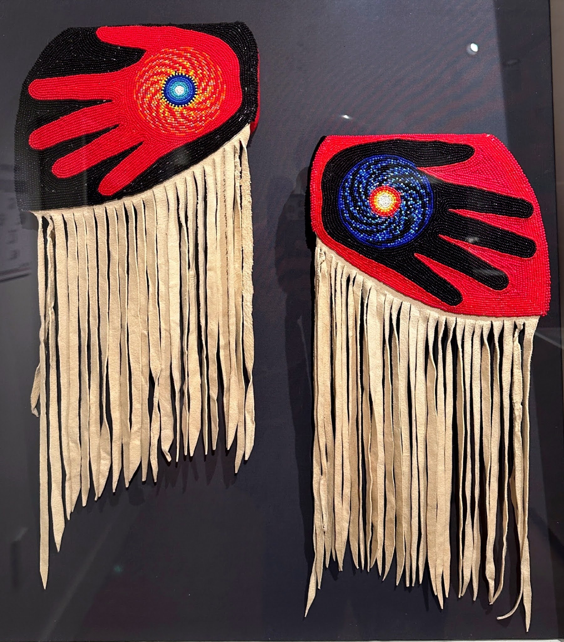
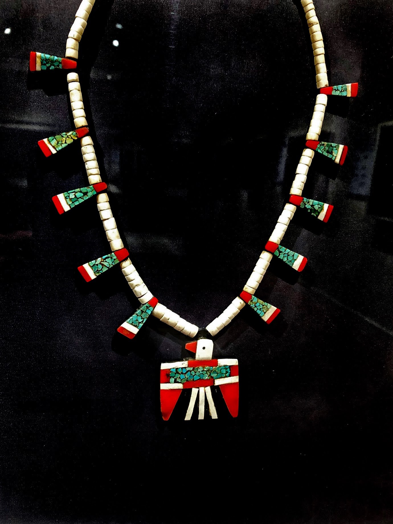
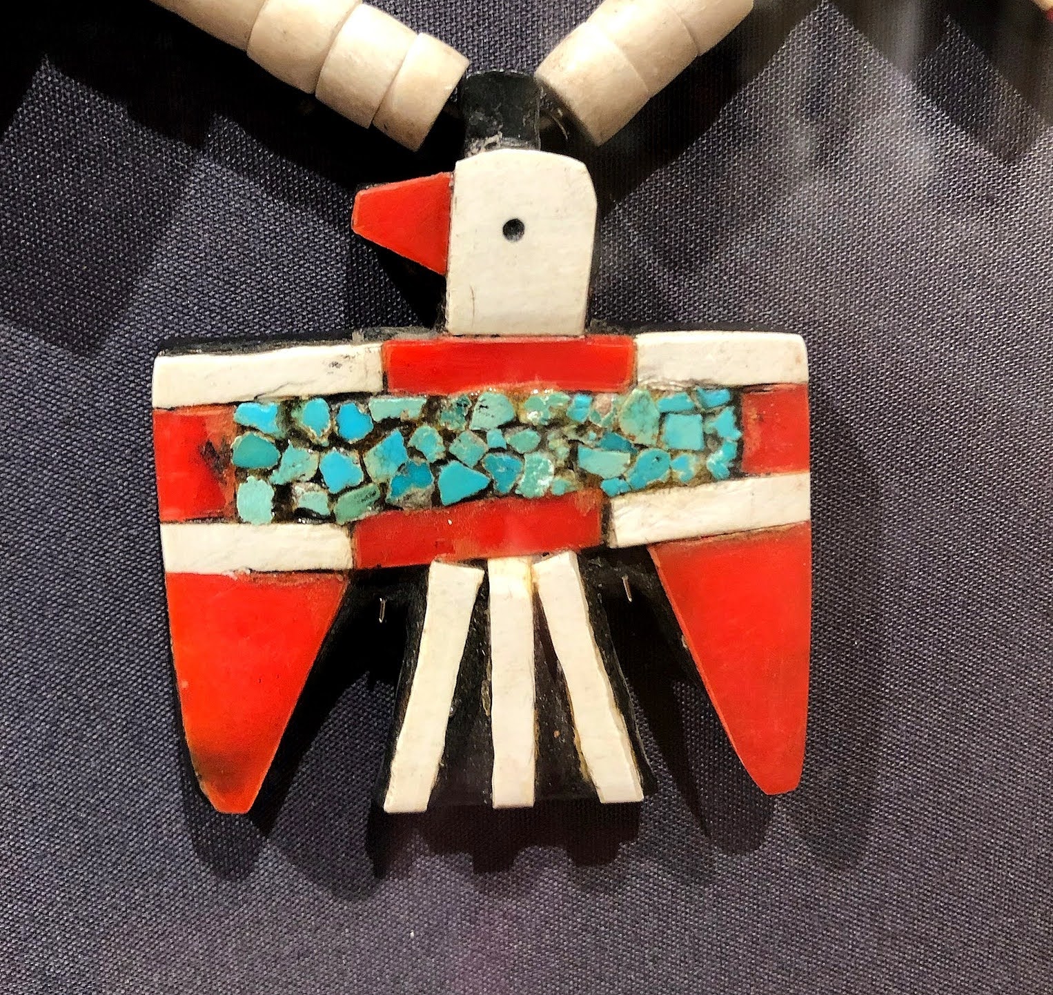
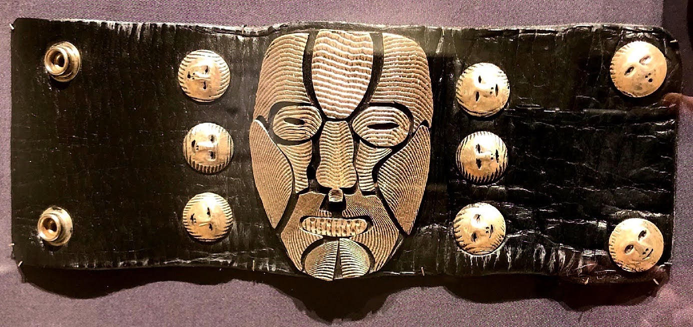
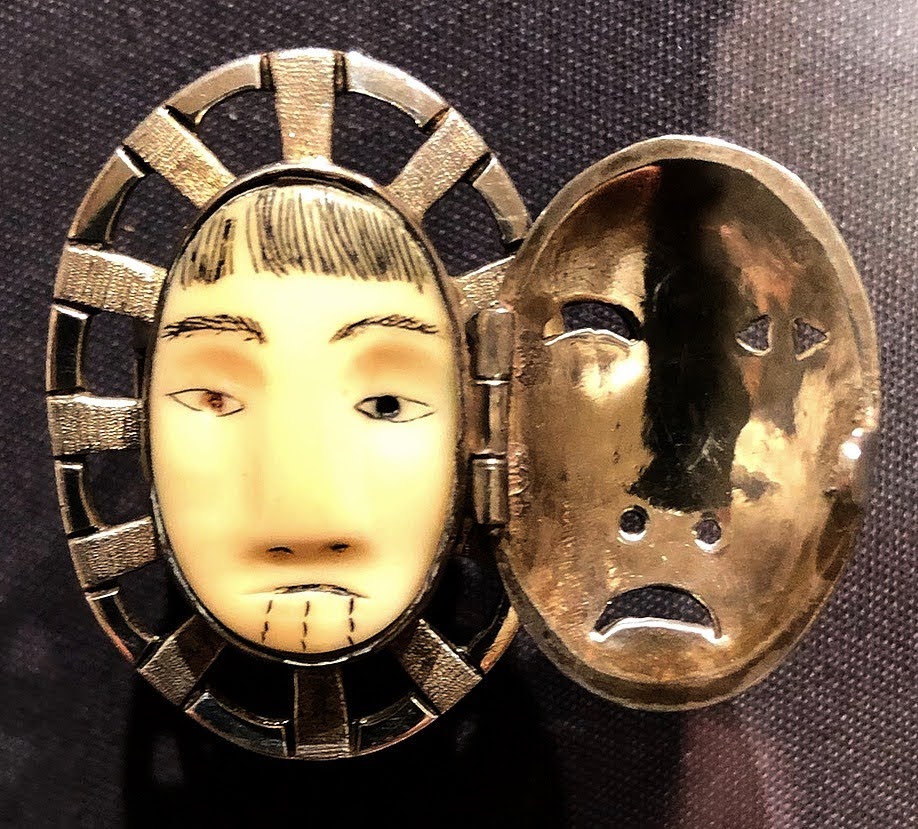
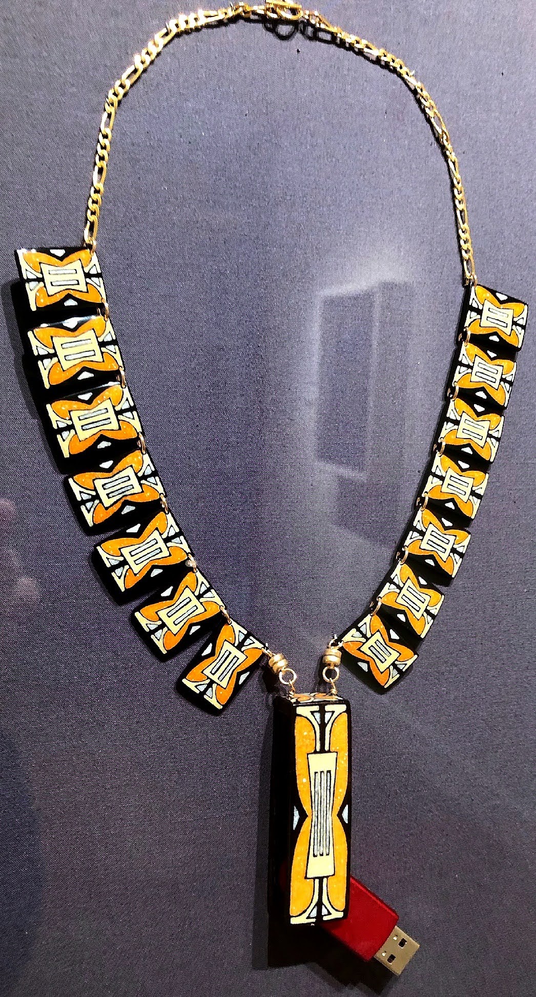
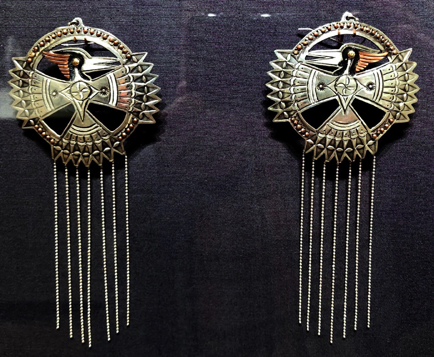
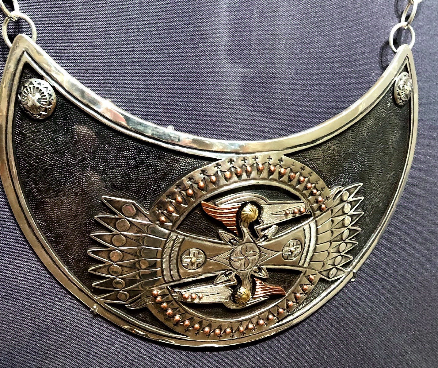
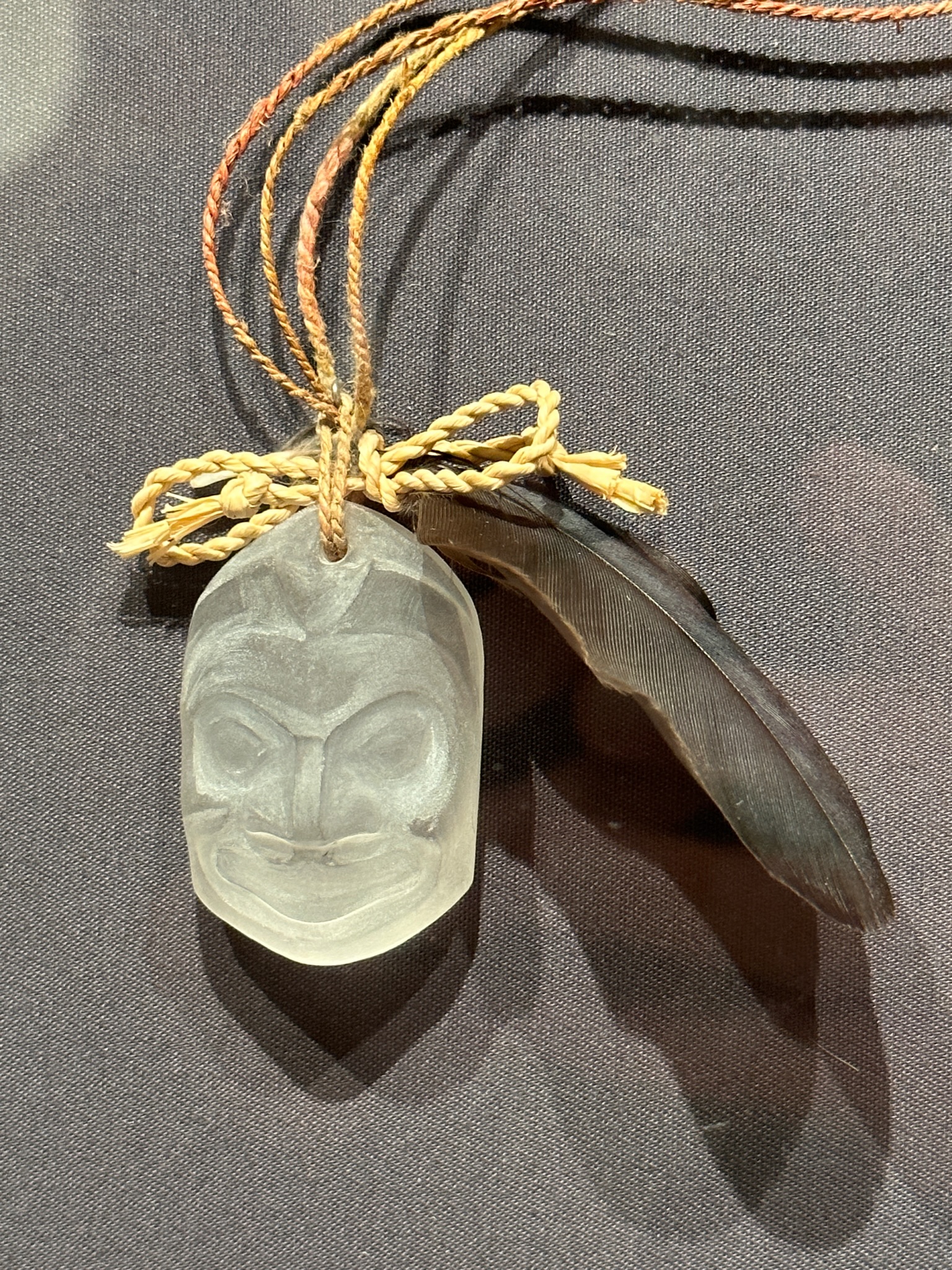
The institute had mounted an exhibit of contemporary jewelry created by more than 100 artists.
It was a short walk to another museum with NARM privileges, the New Mexico Museum of Art. Before we delve into the exhibits, I will indulge in its architecture.
The Architecture
The museum was completed in 1917 in the Pueblo Revival style which was codified 40 years later as one of a few style options allowed in central Santa Fe. The architecture imitates the appearance of traditional adobe Pueblo architecture using rounded corners, irregular parapets, and thick, battered walls often stuccoed and painted in earth tones. The style includes projecting wooden roof beams called vigas, and curved and stylized beam supports called corbels.
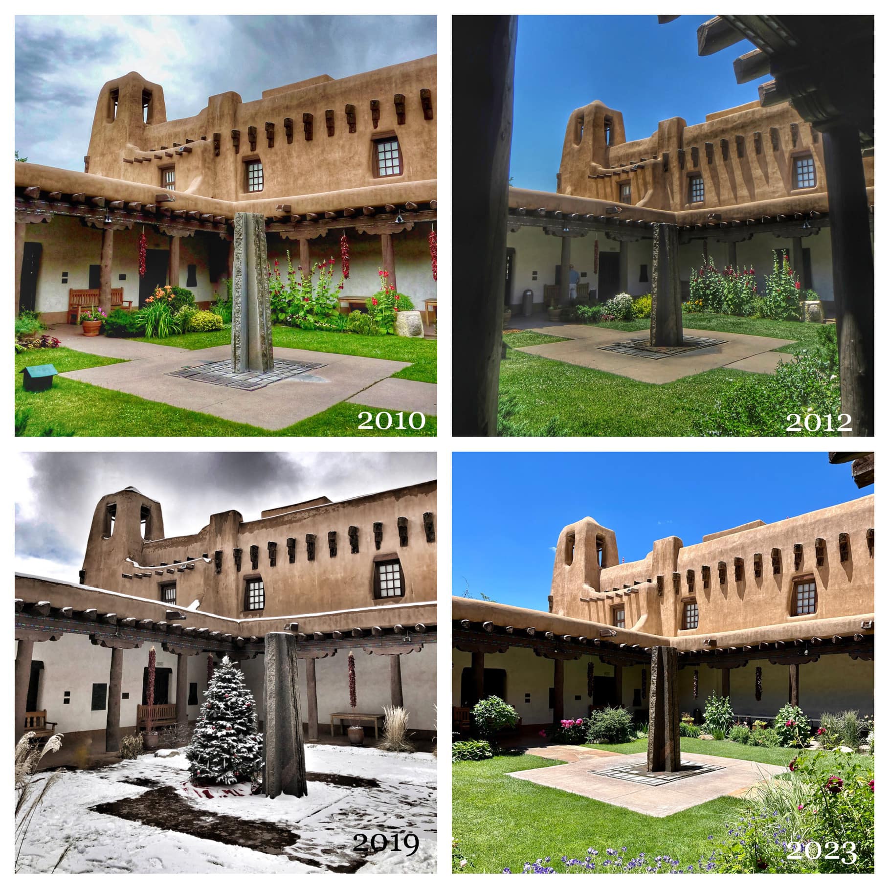
Here is the same view of the courtyard from some of my visits over the years:
Views over the years of the courtyard at the New Mexico Museum of Art
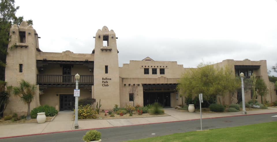
The museum was designed by architects Isaac Hamilton Rapp and William Morris Rapp as an enlarged and modified version of the New Mexico building they made for the 1915 Panama-California Exposition in San Diego, which still stands as the Balboa Park Club. They modeled the structure after the church and convent at Ácoma Pueblo.
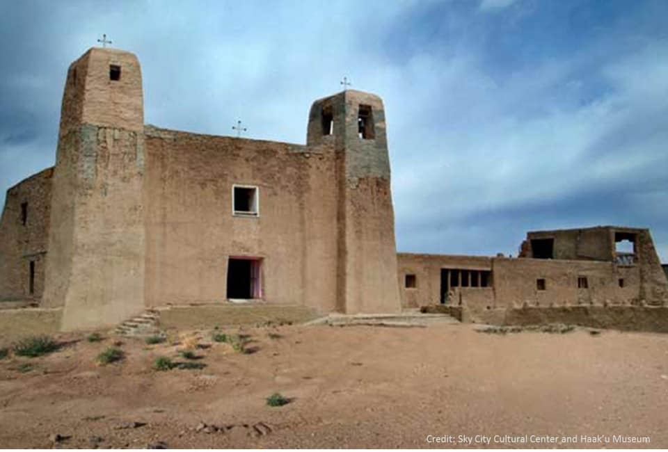
New Mexico building made for the 1915 Panama-California Exposition in San Diego, which still stands as the Balboa Park ClubMission San Estévan del Rey at the Ácoma Pueblo
Mission San Estévan del Rey, constructed between 1629 and 1641 at the Ácoma Pueblo, is the oldest church of European construction remaining in New Mexico. It was founded by Franciscan Father Juan Ramirez in 1629. Ácoma was hostile to Spanish rule, and the inhabitants participated in the 1680 Great Pueblo Revolt. The building was repaired and restored in 1810, 1902, and 1924. Ácoma is a “living” pueblo and has been continuously occupied since the 12th century.
Isaac Hamilton Rapp went on to design the beautiful La Fonda Hotel off the plaza. Upon completion of the original incarnation of La Fonda in 1920, he promptly retired to Trinidad, Colorado, having lost his architectural partners to premature deaths. Rapp’s contributions to Santa Fe architecture precede that of well known southwestern architect John Gaw Meem, who arrived four years after Rapp’s retirement and became his major successor. Meem ensured that the regional Spanish Pueblo Style that Rapp helped to recapture became a norm in Santa Fe by 1957, as enforced by strict city ordinances.
In addition to the courtyard, we looked at the murals in the museum’s St. Francis auditorium, which looks like a church but is a secular gathering place.
St. Francis Audtorium
The Art
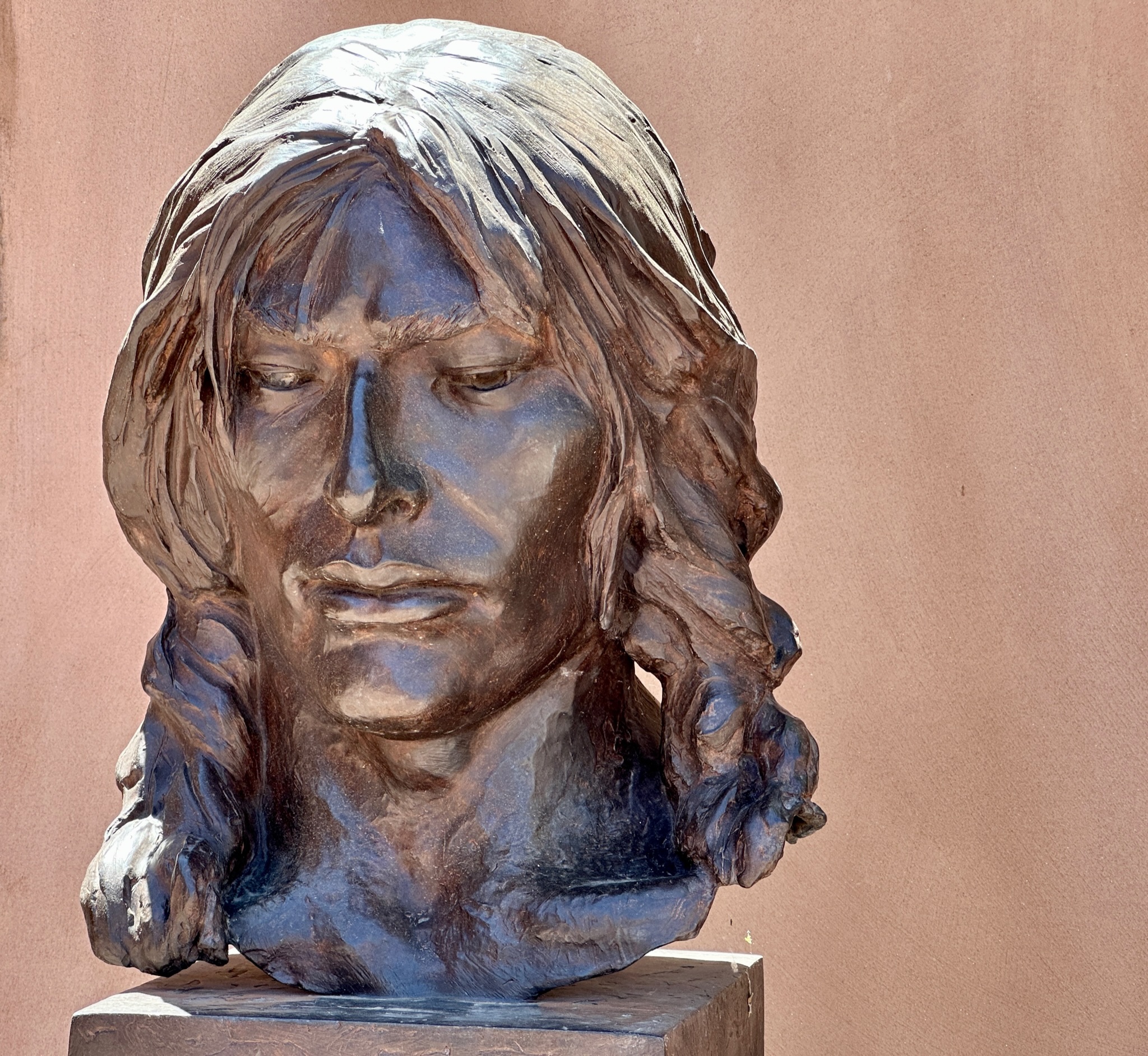
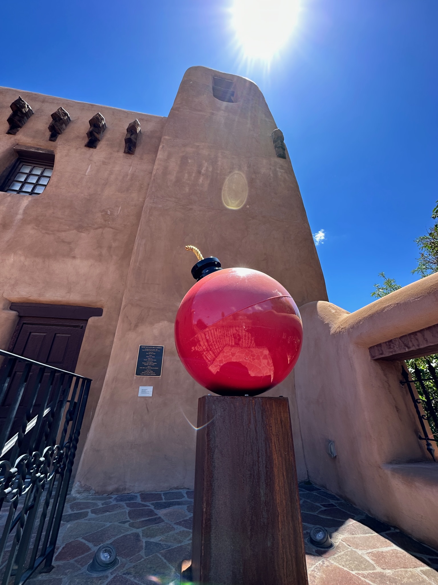
You pass through the back of the auditorium to reach the exterior sculpture garden, where my favorite works were the large Native American by Glenna Goodacre and Martin Cary Horowitz’s immense Cherry Bomb.
There was an exhibit of glasswork that included a self-portrait by Frederick Hammersley.
Self-portrait by Frederick Hammersley
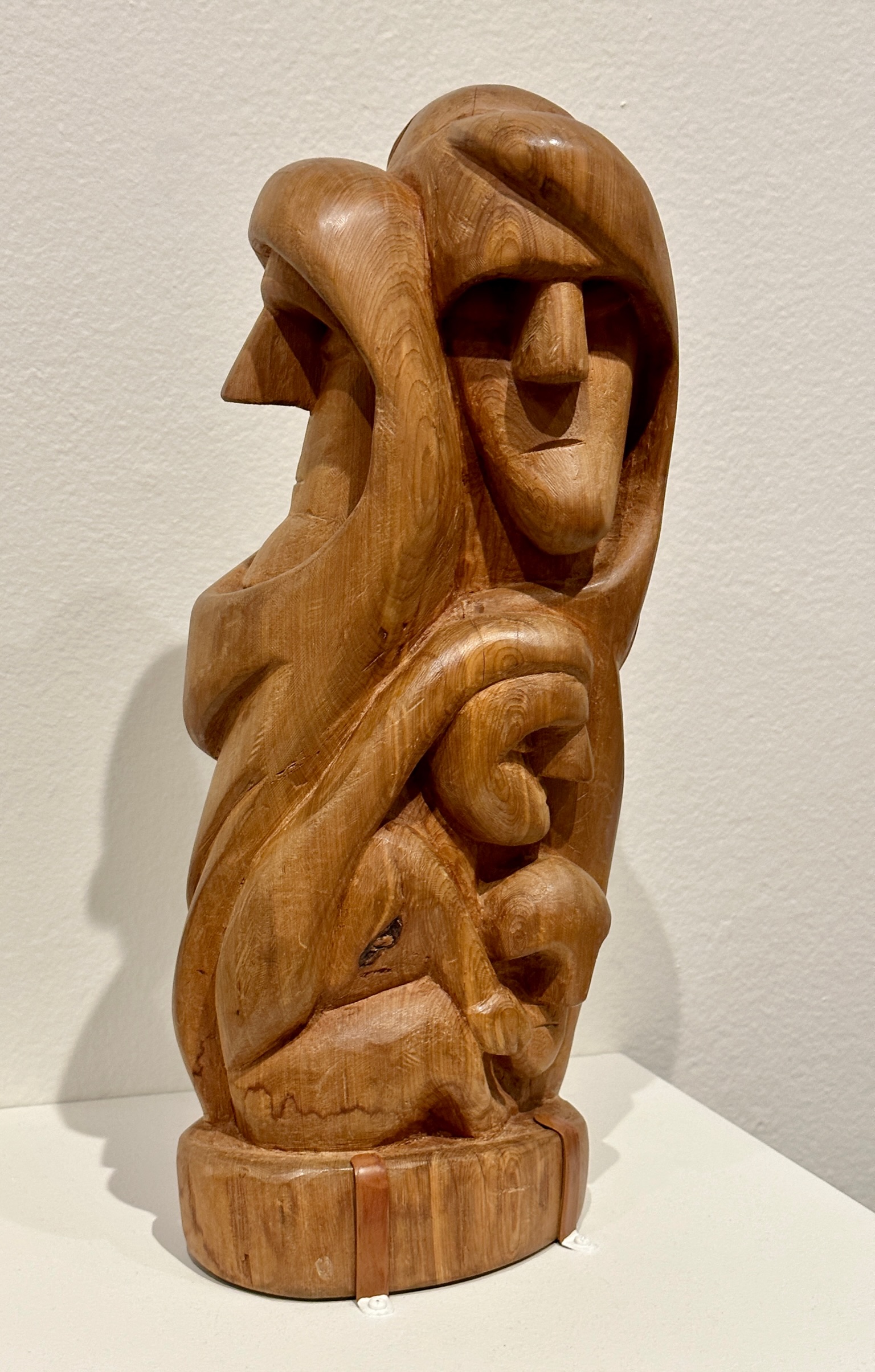
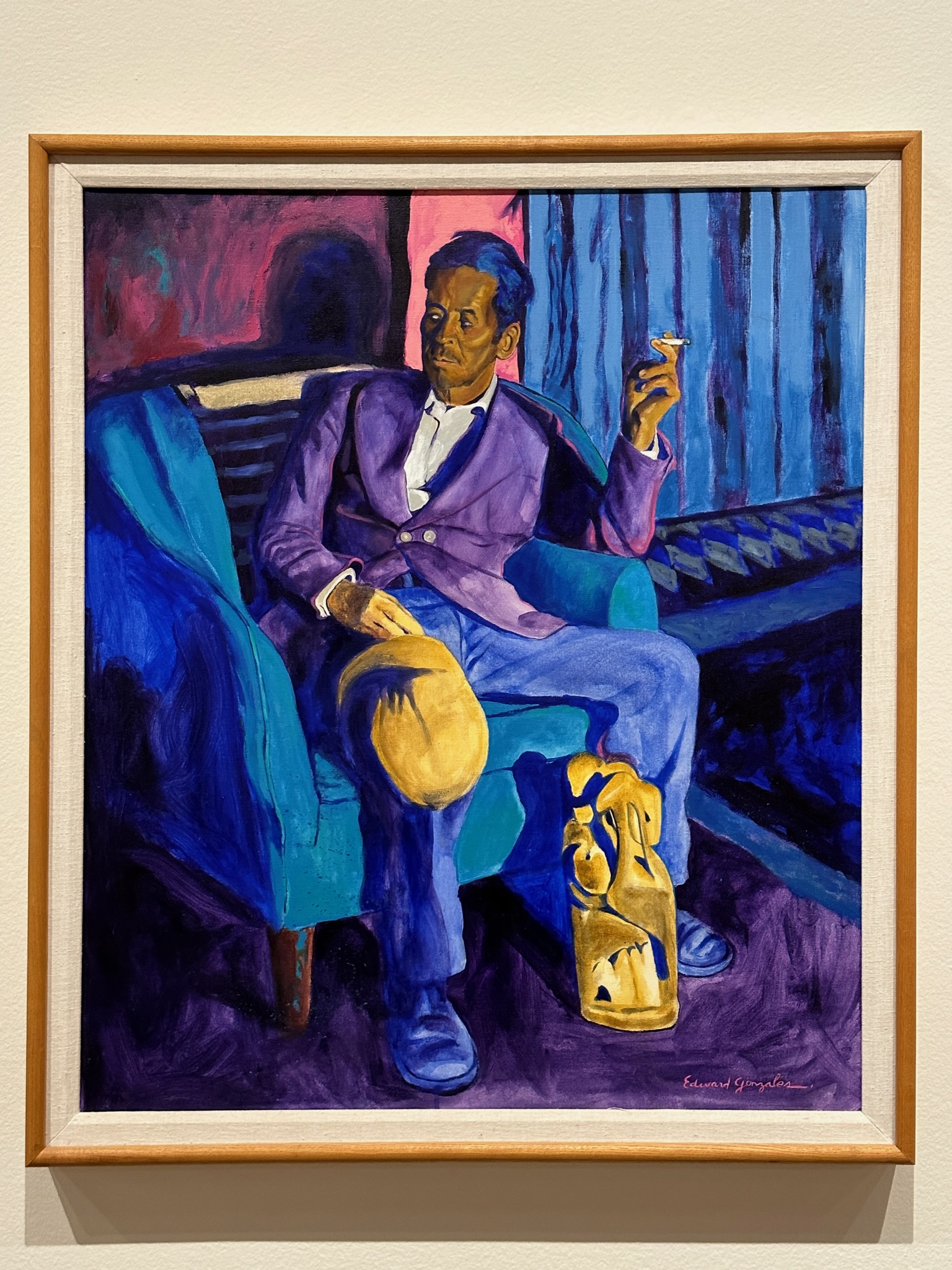
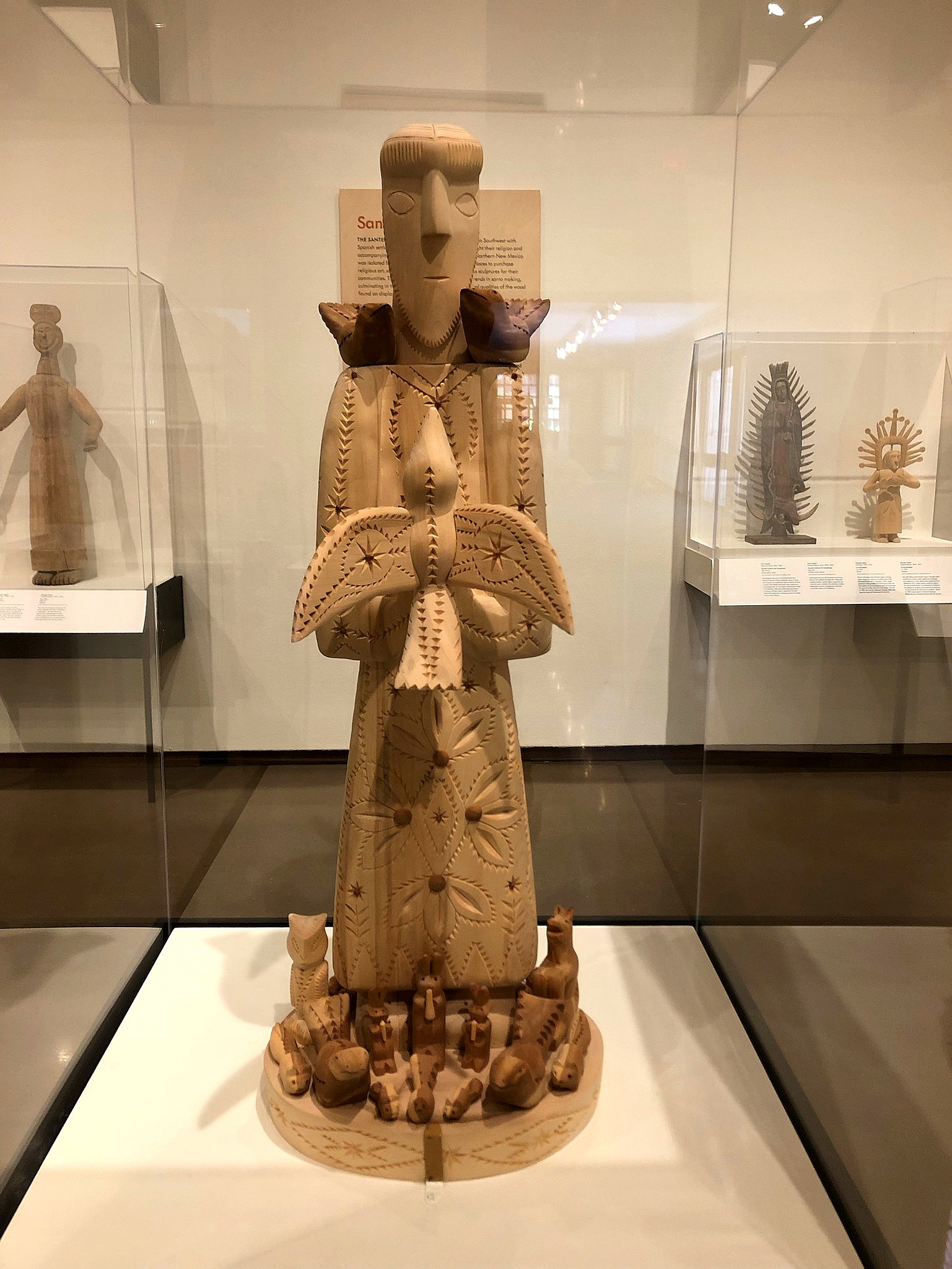
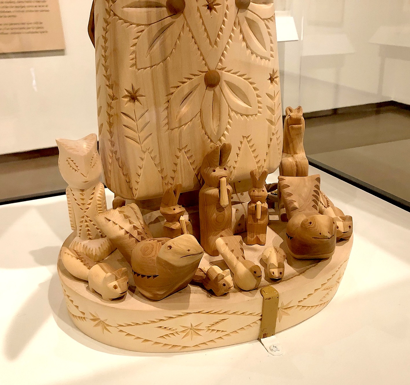
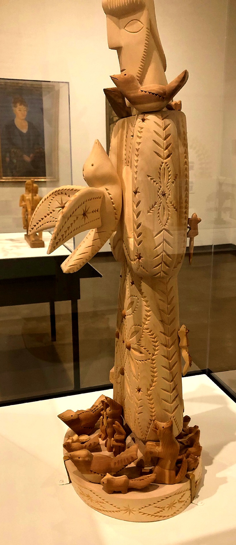
We lingered at a woodcarving exhibit. I liked how they displayed a work by Patrocino Barela, and included a painting of him by Edward Gonzales.
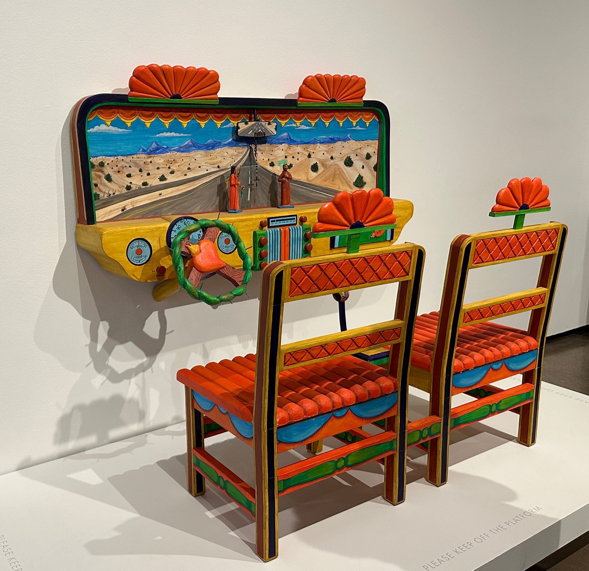
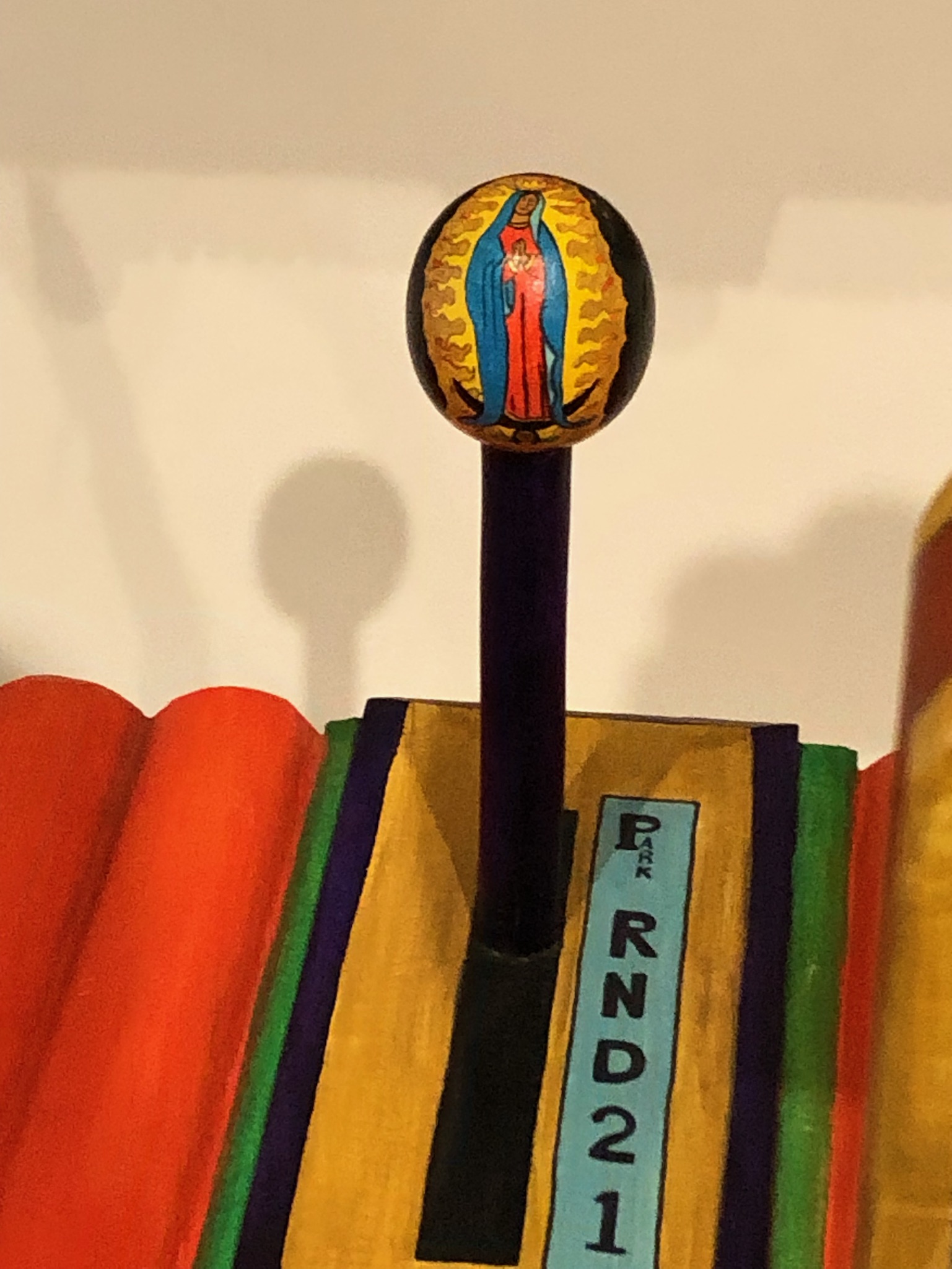
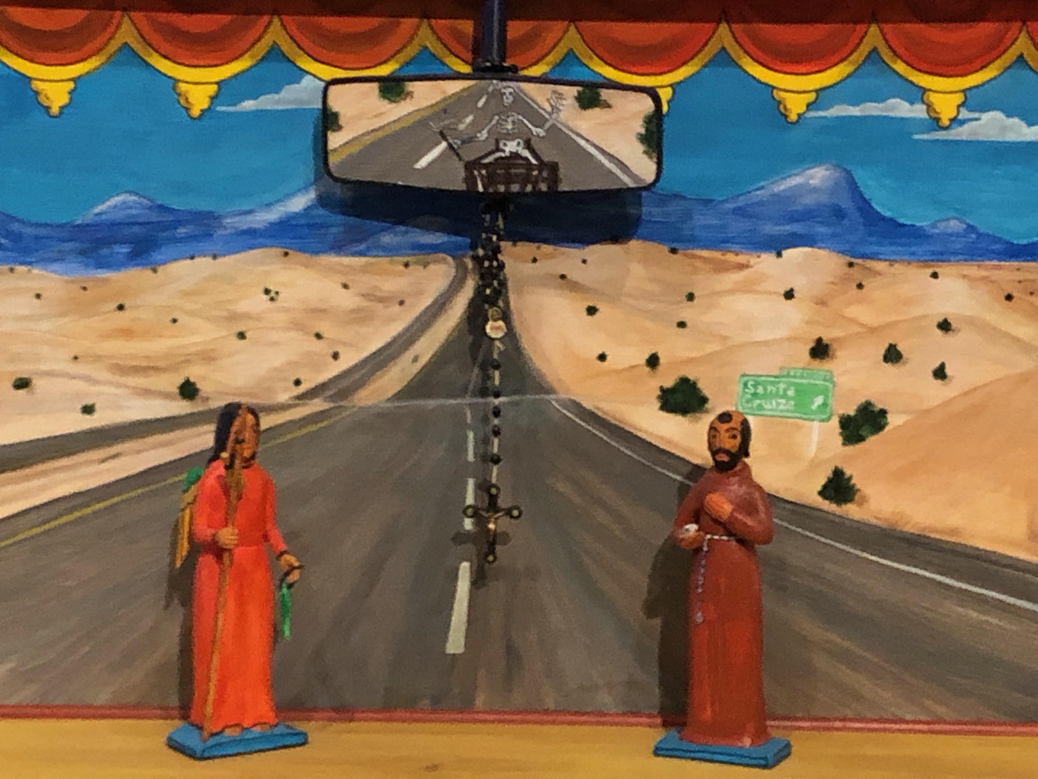
Wendy and I were impressed by the Chima Altar, Bertram’s Cruise by Luis Tapia. It was a dashboard altar inspired by his mother’s car.
A death cart with the skeletal figure of Doña Sebastiana is visible in the rearview mirror.
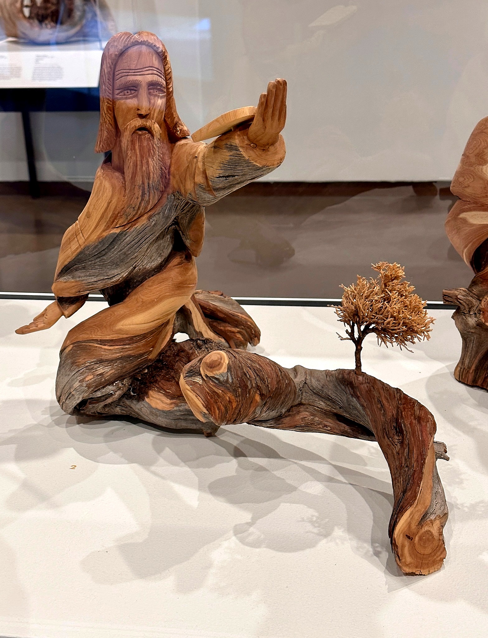
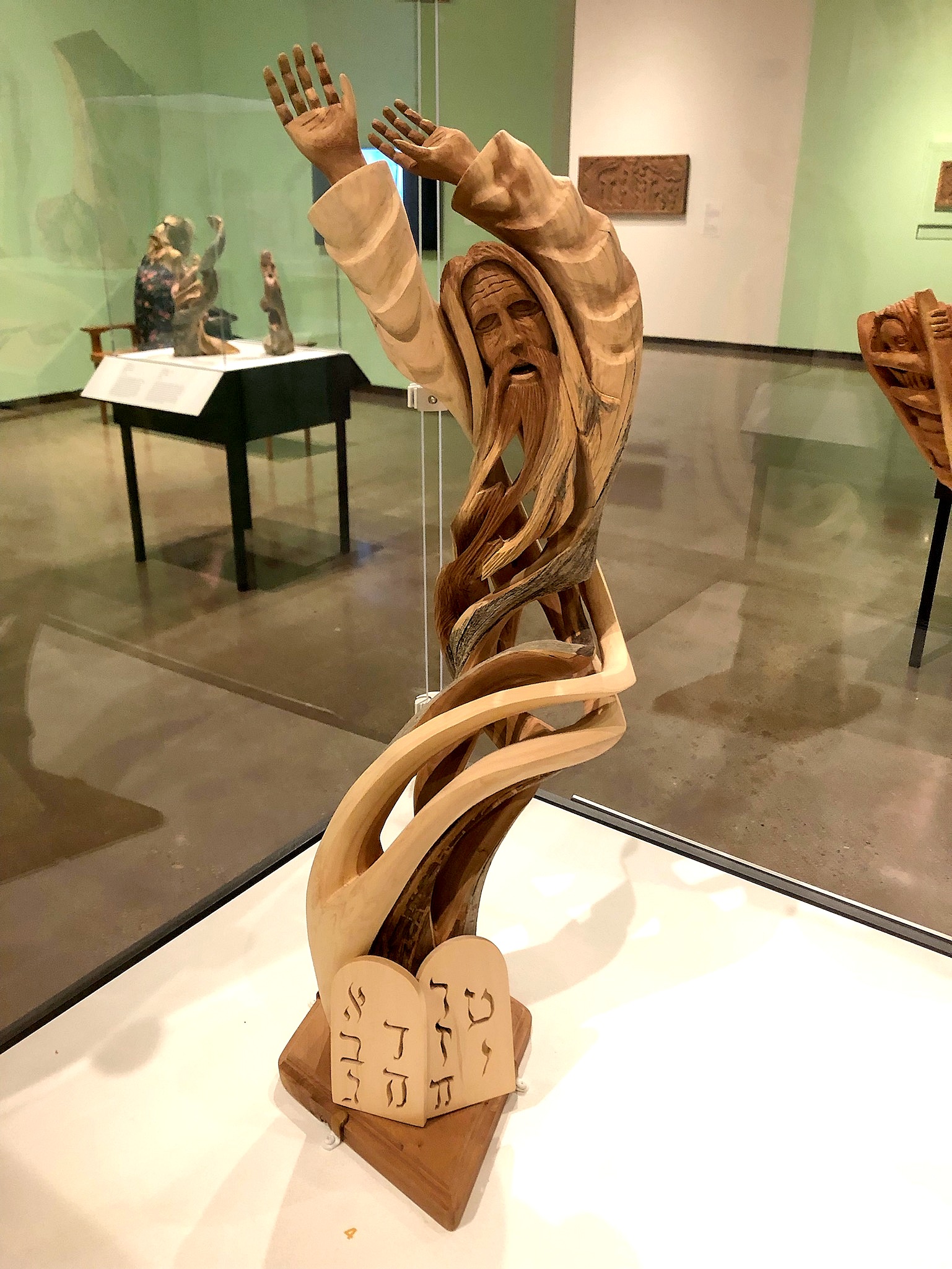
There were striking cedar carvings of Moses by Leonardo and Jacob Salazar.
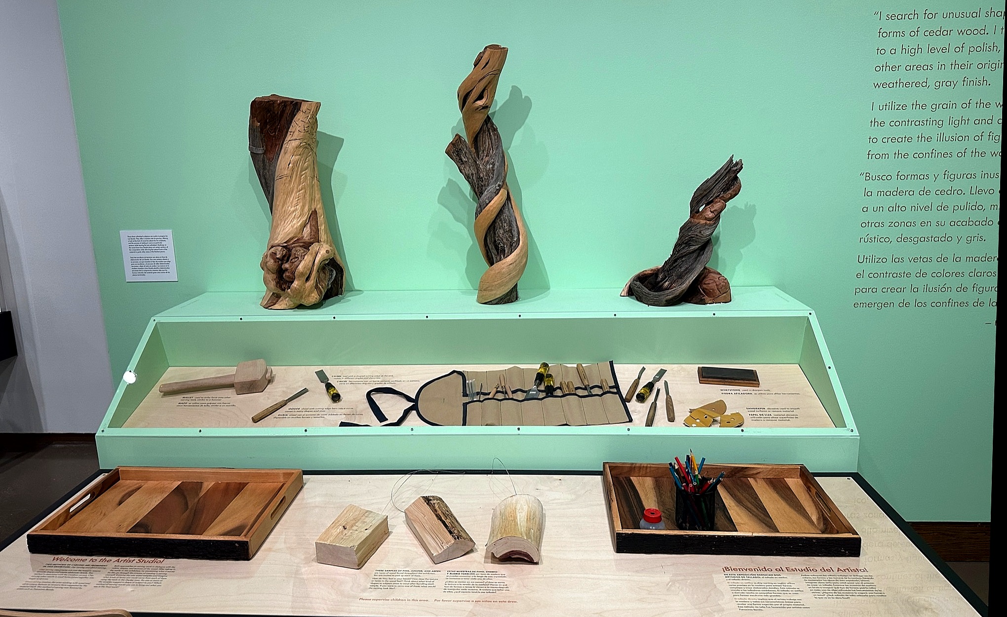
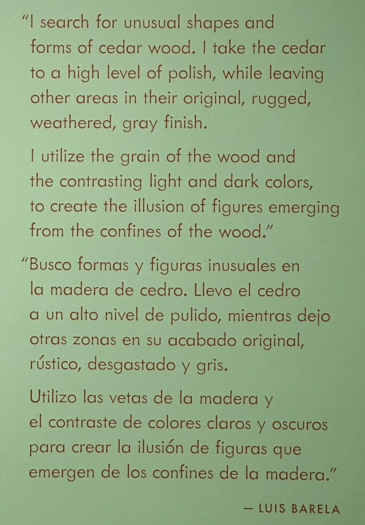
A display of the the tools of Luis Barela accompanied some of his works.
Wendy liked the Saint Francis of Assisi carvings in cedar and aspen by Gloria López Cordova.
We had dinner at the Plaza Cafe’s south side location, dining on chicken fried steak and tacos. Wendy said their green chile was good.
Nedra Matteucci Galleries and Garden
I prefer museums over galleries, but I had read that the garden at the Nedra Matteucci gallery shouldn’t be missed. So the next day we took another 15-minute walk past the state capitol to its location south of the many galleries along Canyon Road.
Forrest Fenn, of treasure hunt fame, launched the gallery in 1972 and sold it to Matteucci in 1988. She reportedly sold it in 2022, saying it would become condominiums. But it was still open and operating for our visit, and the staff were welcoming and congenial.
The works were completely out of our price range, filling room after room of a rambling building. An example is that Henry C. Balink’s Sioux Chief – 1930s Pine Ridge Reservation was for sale at $125,000.
Sioux Chief – 1930s Pine Ridge Reservation by Henry C. Balink
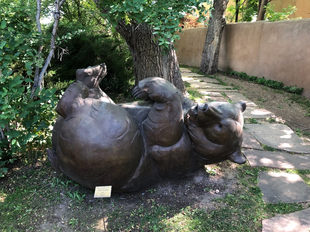
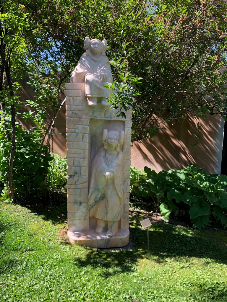
The sculpture garden was indeed impressive, with a large elephant statue, several different bear statues, and more scattered about the beautiful grounds. The property was a four-acre tract with an orchard and vegetable farm when Forrest Fenn acquired it over 50 years ago.
Nedra Matteucci Galleries Sculpture Garden
My favorite work was Ya Ta Hey by Glenna Goodacre. That is a Navajo greeting that literally means it is good.
Ya Ta Hey by Glenna Goodacre
Since two of her pieces around town had arrested my attention, I looked up Glenna Goodacre. She passed in 2020 at age 80. Two of her most well-known works are the Vietnam Women’s Memorial in Washington, DC and the observe (heads) side of the Sacajawea dollar coin.
State Capitol
Wendy and I then walked back along the Paseo De Peralta past the 1966 state capitol roundhouse. We decided to see if there was art inside, and indeed there was, both near the rotunda and all along the corridors.
There was an interesting abstract piece by Margarete Bagshaw in a display area.
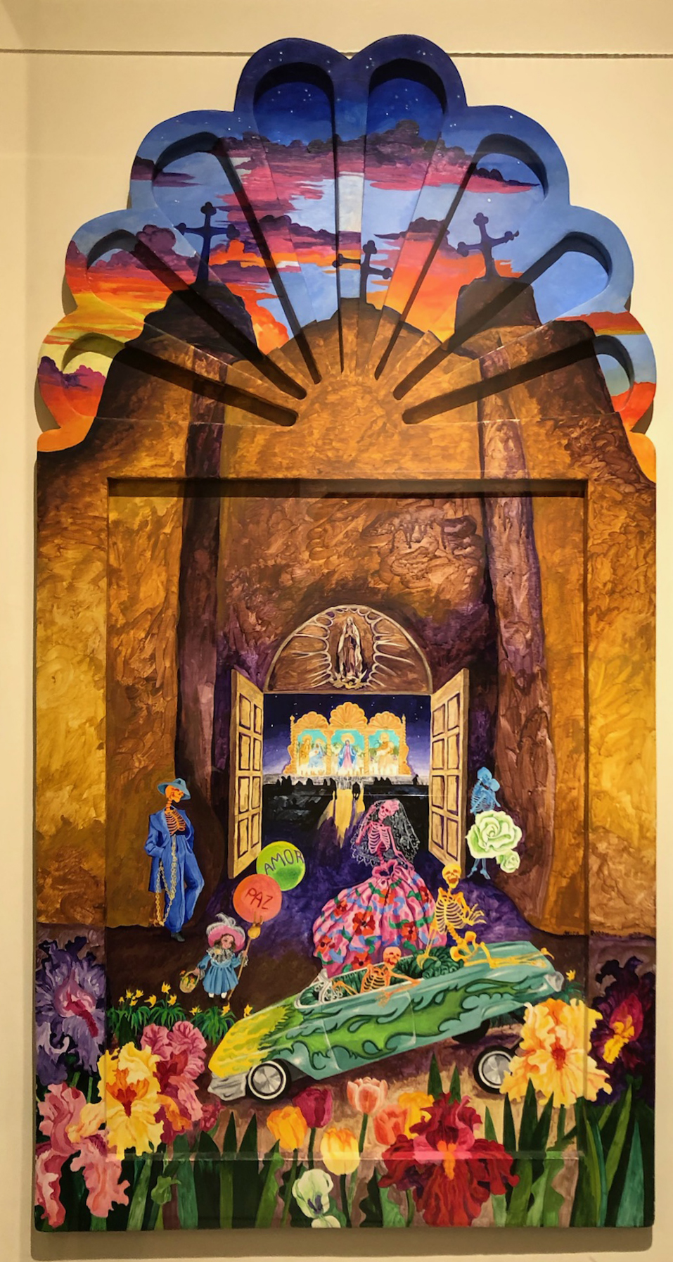
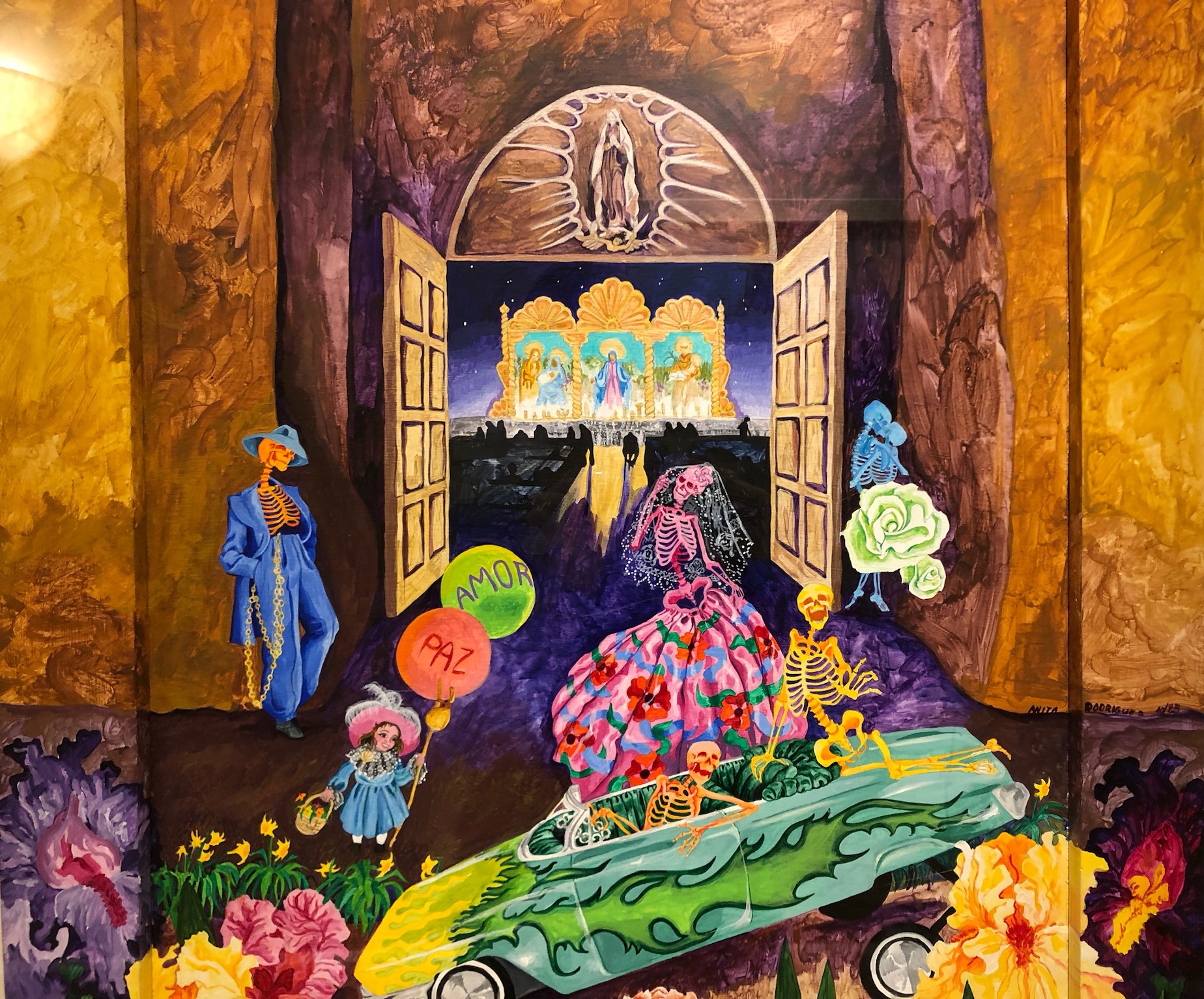
Along the first-floor corridor, Wendy liked My Lowrider Heaven by Anita Rodriguez.
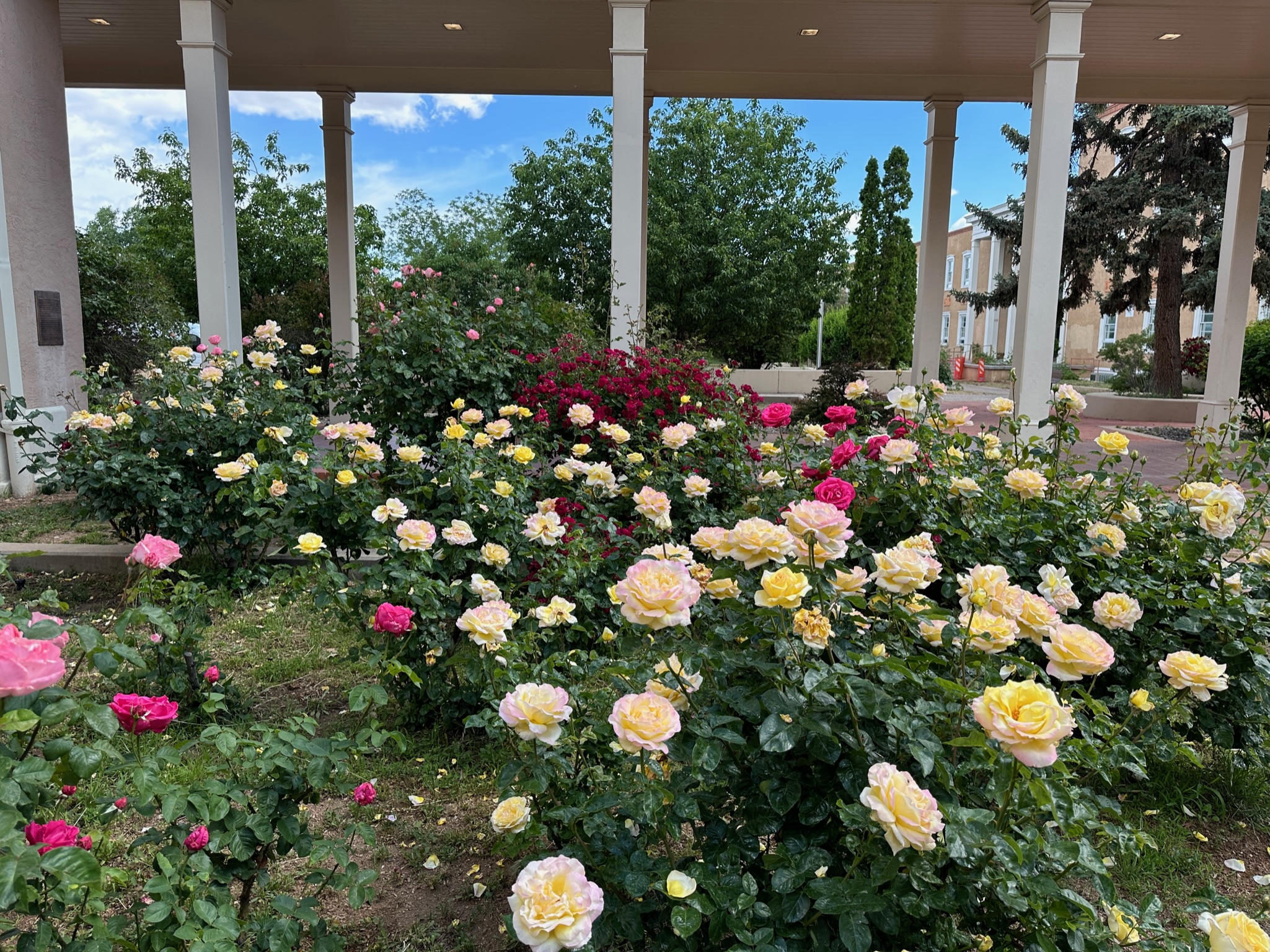
We made the round of the entire first floor, deciding to save the second floor for a future visit. Wendy remembered that a section of the capitol grounds has large rose bushes, and she requested that we go check them out. They did not disappoint.
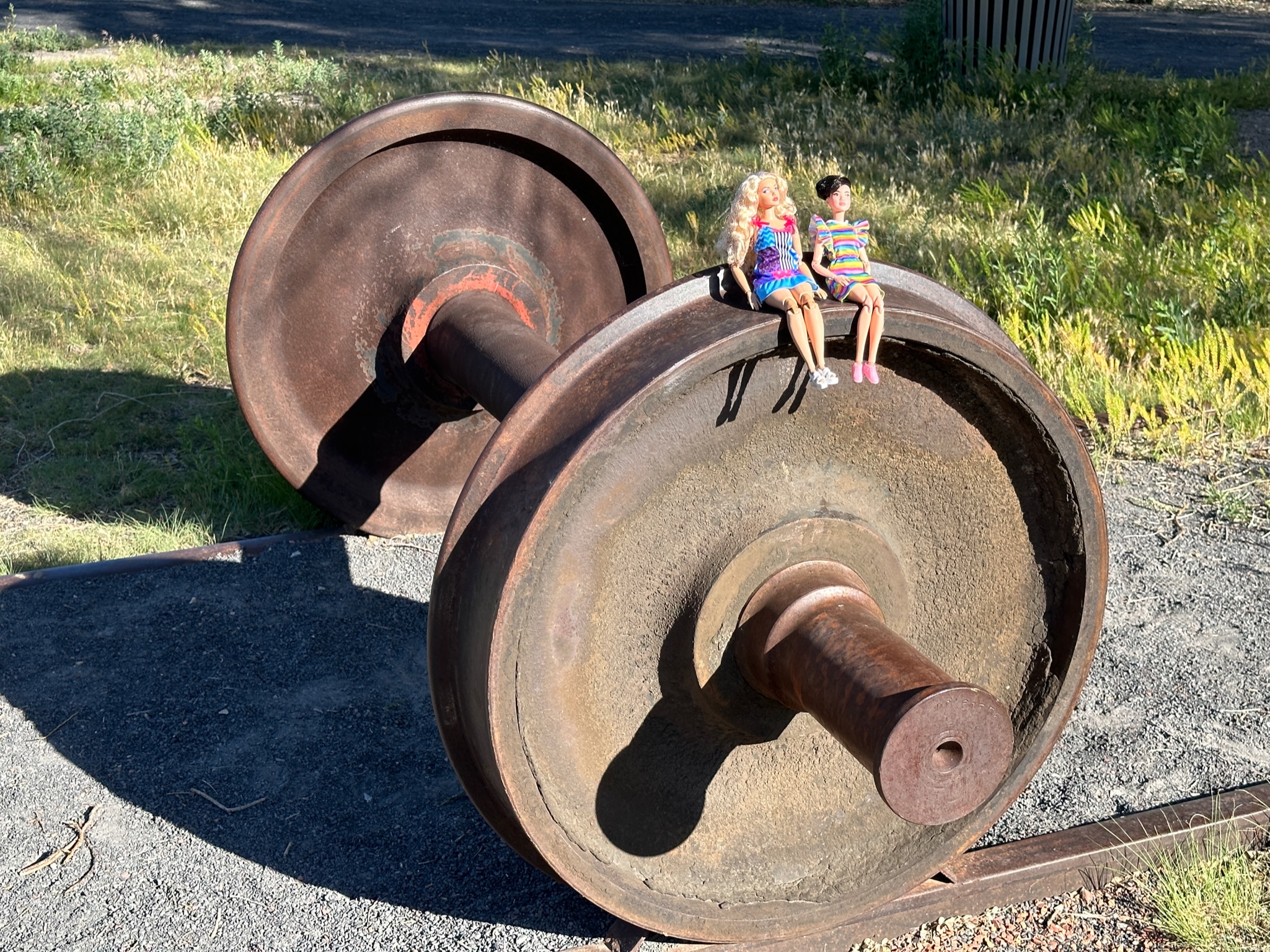
Rail Yard
We made our way back to the casita, where we had Doordash bring us some Burrito Company food. Then we walked over to the Rail Yard Park, where Wendy’s Barbies posed by the plants, and on top of an axle and wheels.
We wrapped up our day with Pizza Centro. On our last evening in Santa Fe, I noticed how the wooden latillas of the casita’s coyote fencing were silhouetted in one of the side windows.
The next day we would take the low road by the Rio Grande to Taos and then cross the Sangre De Cristo Mountains to Trinidad, Colorado.
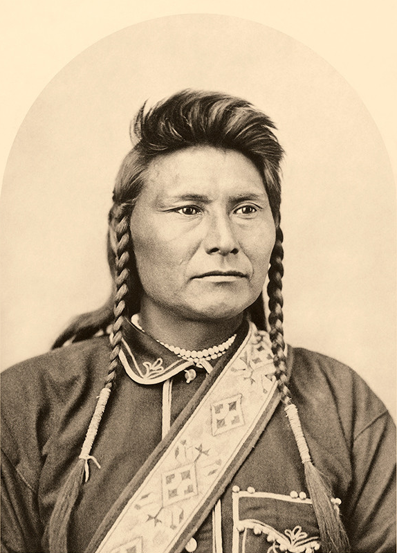
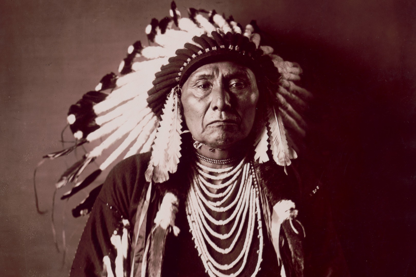
Earlier this summer, Wendy and I were in Trinidad, Colorado at the A.R. Mitchell Museum of Western Art. There was an exhibit of photographs by Edward Curtis, and I wasn’t at all surprised to see a print of a photograph he took in 1903 — of a man who would be dead within a year.
Seeing that famous portrait of Chief Joseph of the Nez Perce took me back almost 50 years to my elementary school days. And that journey in the mind not only led me to consider the Nez Perce War, but the Culture Wars of today.
Chief Joseph in 1903
I was in 4th or 5th grade at Putnam City Central Intermediate in Warr Acres, one of many Oklahoma City suburbs. Each student was assigned a different First Peoples tribe we were to research and present about. I was dissatisfied with what little the school’s library had on the Nez Perce. Being a precocious student, my teacher made a special arrangement for me.
The PC Central campus stretched for 4/10 of a mile along US 66 with multiple district administration buildings scattered about its perimeter. I was told to go west a few blocks and across a back street to an anonymous wooden building. It was the home of the district’s “Indian Education” program, and they had a far more extensive and advanced collection I was allowed to search through on multiple visits. I remember climbing up on a chair to retrieve heavy volumes and loading and watching filmstrips as I tried to grasp the tribe’s tragic history.
The Nez Perce War
What I found made a lifelong impression on me about betrayal, adversity, leadership, and fortitude. And now, almost five decades later, I can simply use Wikipedia, with some cross-checking on its accuracy, to share the story again.
Lewis & Clark Encounter the Nez Perce
At the time of the Lewis and Clark expedition, the nimíipuu, whom French fur traders called the Nez Percé, or pierced nose, had more than 70 permanent villages, of 30 to 200 individuals each, across parts of present-day Washington, Oregon, Montana, and Idaho. The tribe fed the explorers and gave them fresh horses, with Lewis and Clark entrusting their worn horses to the Nez Perce to be fattened up while they ventured onward.
When the Corps of Discovery returned the following spring, again hungry and exhausted, the tribe constructed a large tent for the explorers and again fed them. The explorers desired fresh red meat and offered an exchange for a Nez Perce horse. The Chief was offended at the idea of an exchange, saying his people had plenty of young horses and if the explorers wanted to use that food, they could have as many as they wanted. The party stayed with the tribe for a month before moving on with their recovered original horses.
Eighty years later, the tribe’s relations with whites were quite different.
Reductions and Betrayals
We took away their country and their means of support, broke up their mode of living, their habits of life, introduced disease and decay among them and it was for this and against this they made war. Could anyone expect less?
General Sheridan
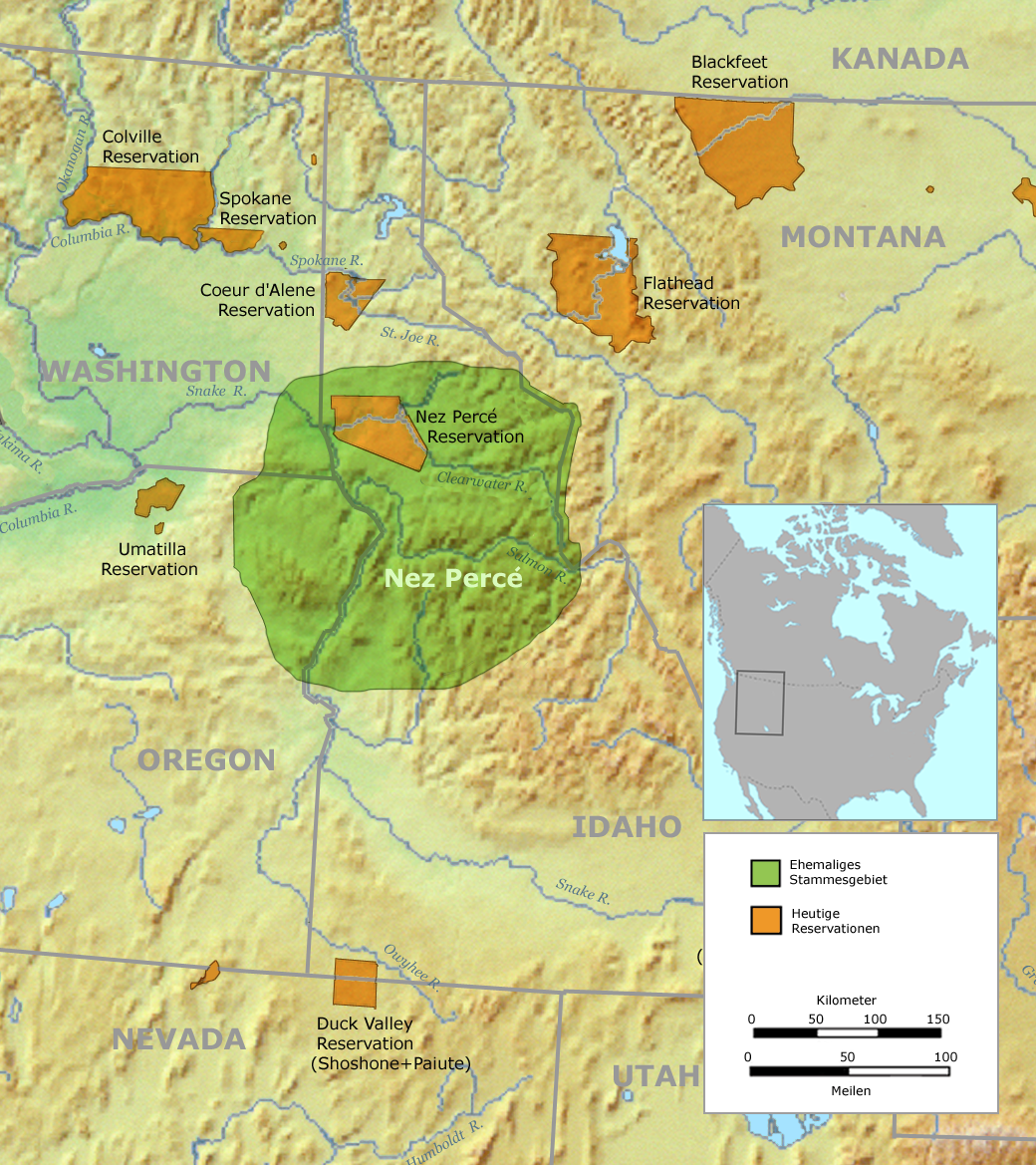
In 1855, the federal government forced the Nez Perce to accept a reservation that was about half of their indigenous territory. The 1855 reservation is in green in the map below.
The land promised to the Nez Perce is in green
Chief Joseph
No white settlers were to be allowed on the reservation without the tribe’s permission. But in 1860 gold was discovered in Idaho and 5,000 gold-seekers rushed onto the reservation. They illegally founded a city on the tribe’s land, and ranchers and farmers followed the miners. The settlers plowed the prairies the tribe depended on for subsistence. The government did not honor the treaty.
Even worse, in 1869, a group of Nez Perce were coerced into signing away 90% of their reservation, leaving them with only the orange area in Idaho within their former, already reduced, and unprotected boundaries.
The Nez Perce who approved the 1869 treaty were mostly Christian, while many Nez Perce who mostly followed the traditional religion refused to move. That included the band of Hin-mah-too-yah-lat-kekt, who we know as Chief Joseph, who lived in the Wallowa valley in northeastern Oregon. Disputes there with white farmers and ranchers led to the murders of several Nez Perce, and the murderers were never prosecuted.
Powderkeg
Tensions between the Nez Perce and white settlers rose in 1876, and General Howard ordered the non-compliant bands to move to the reservation in 30 days, jailing their old leader, Too-hul-hul-sote, for speaking against the move. The other tribal leaders, including Chief Joseph, considered military resistance to be futile and reported to Fort Lapwai as instructed.
Days before the deadline, the White Bird band of the tribe held a tel-lik-leen ceremony with warriors parading on horseback while boasting of their deeds. One old warrior challenged the presence of several young participants whose relatives’ deaths at the hands of white settlers had gone unavenged. Three of the young warriors set out to nearby settlements and killed four white men and wounded another.
Caught up in the fervor, sixteen more young men rode off to raid settlements. Chief Joseph was away from camp when they killed at least another 14 whites. When Joseph returned to camp to discover this catastrophic development, he considered an appeal for peace, but he realized it would be useless.
The Battle of White Bird Canyon
General Howard sent out 130 men to punish the Nez Perce. The Nez Perce sent out a truce party under a white flag, with orders not to fire unless fired upon. For reasons unknown, civilian volunteer Arthur “Ad” Chapman, who could speak their language, made first contact with the Nez Perce truce party and fired at them.
The Nez Perce returned fire, beginning the Battle of White Bird Canyon. 34 U.S. Cavalry soldiers were killed and two wounded, with two volunteers wounded. In contrast, only three Nez Perce warriors were wounded, and the Nez Perce warriors retrieved 63 carbines, many pistols, and hundreds of rounds of ammunition. They had won, despite being outnumbered two to one and fighting uphill with inferior weapons. As for Chief Joseph, he may have fought in the battle, but he was not a war leader.
The Fighting Retreat
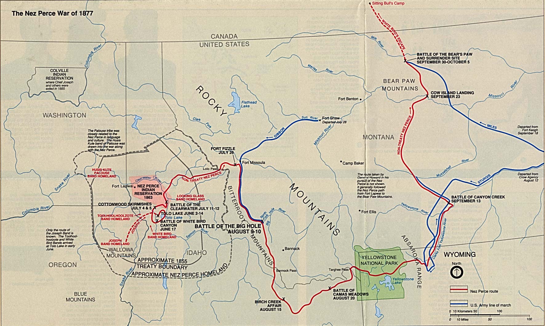
The Nez Perce knew that victory was only temporary, and thus began their desperate fighting retreat across 1,170 miles of Oregon, Idaho, Wyoming, and Montana. 250 Nez Perce warriors and 500 women and children, along with 2,000 head of horses and other livestock, set off toward Montana, seeking assistance from the Crow.
The map below shows their incredible fighting journey from their homelands through the Bitterroot Mountains and across Yellowstone National Park. Having been rebuffed by the Crow, they headed northward in a failed attempt to reach Sitting Bull’s Camp in Canada. Over several months they outmaneuvered and battled more than 2,000 pursuing U.S. soldiers.
The long fighting retreat of the Nez Perce in 1877
The Surrender
They were only 40 miles south of the Canadian border, believing they had shaken off their pursuers, when General Miles led a surprise attack on September 30. There was a fierce battle followed by a siege in freezing weather.
Joseph, who was in charge of protecting the camps during the long retreat, said his band could have escaped if they had left their wounded, old women, and children behind. But many of the war chiefs had died, and he was unwilling to continue. He negotiated to allow his people to return to the reduced reservation in Idaho.
These words attributed to Chief Joseph moved me greatly when I first read them almost 50 years ago:
Tell General Howard I know his heart. What he told me before, I have it in my heart. I am tired of fighting. Our chiefs are killed; Looking Glass is dead, Too-hul-hul-sote is dead. The old men are all dead. It is the young men who say yes or no. He who led on the young men is dead.
It is cold, and we have no blankets; the little children are freezing to death. My people, some of them, have run away to the hills, and have no blankets, no food. No one knows where they are—perhaps freezing to death. I want to have time to look for my children, to see how many I can find. Maybe I shall find them among the dead.
Hear me, my chiefs! I am tired; my heart is sick and sad. From where the sun now stands, I will fight no more forever.
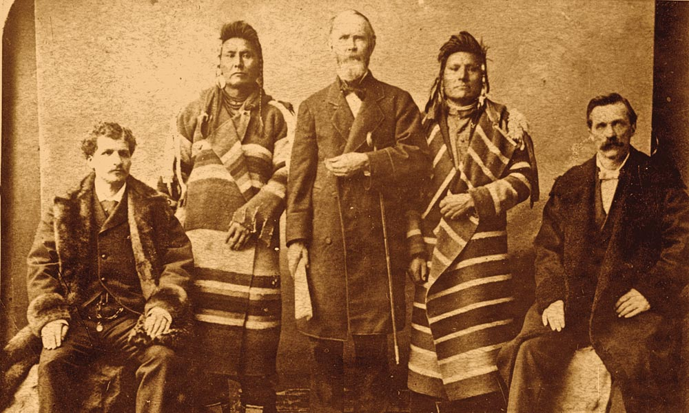
But Chief Joseph did not speak those English words. His speech had to be translated. And who was the translator? None other than the civilian Ad Chapman, who had fired upon the truce party almost four months earlier, setting in motion the Nez Perce War.
Chief Joseph is second from left; Arthur “Ad” Chapman is at far right
Betrayal and Exile
As an elementary student, I shared Chief Joseph’s famous speech, and ended the tale there. But there were more betrayals to come, including seven years of exile in what would become Oklahoma.
General of the Army Sherman violated the surrender terms, overruling allowing the Nez Perce to return to Idaho. Chief Joseph and his followers were taken to Fort Leavenworth, Kansas and held as prisoners of war for eight months in a swampy bottomland. One author described them as “400 miserable, helpless, emaciated specimens of humanity, subjected for months to the malarial atmosphere of the river bottom.”
Chief Joseph travelled to Washington, DC to plead that his people be allowed to return to Idaho or at least be given land in Indian Territory. He met with the President and Congress.
When I think of our condition, my heart is heavy. I see men of my own race treated as outlaws and driven from country to country, or shot down like animals. I know that my race must change. We cannot hold our own with the white man as we are. We only ask an even chance to live as other men live. We ask to be recognized as men. We ask that the same law work alike on all men. If an Indian breaks the law, punish him by the law. If a white man breaks the law, punish him also.
Let me be a free man—free to travel, free to stop, free to work, free to trade where I choose, free to choose my own teachers, free to follow the religion of my fathers, free to think and talk and act for myself—and I will obey every law or submit to the penalty. Whenever the white man treats the Indian as they treat each other, then we will have no more wars. We shall all be alike—brothers of one father and one mother, with one sky above us and one country around us, and one government for all.
from Chief Joseph’s speech at Lincoln Hall, Washington, DC in 1879
So Chief Joseph’s people were allowed to leave Leavenworth, not for Idaho, but to be relocated on a small reservation near modern-day Tonkawa, Oklahoma. Conditions in “the hot country” were little improvement over Leavenworth, and many died of epidemic diseases during their seven-year exile there.
Never to Return Home
In 1885, Joseph and his followers were finally granted permission to return to the Northwest. They were allowed to settle on the Colville Reservation in Washington at the town of Nespelem.
In 1899, the government finally offered Joseph’s people allotments on the Nez Perce reservation in Idaho. But the Nez Perce there, who had accepted the 1869 treaty, had converted to Presbyterianism. Chief Joseph declined, still hoping to return to his home in the Wallowa Valley in northeast Oregon.
By 1901, the Colville Reservation had been cut in two, with the government neglecting to pay an agreed sum for the northern half. The southern half was opened for mineral entries and prospectors streamed in. A visitor to a mining camp within two miles of Chief Joseph’s tepee said the herds of tribal ponies were startled twice daily by rock blasting. There were about 1,000 Nez Perce in Nespelem, of which 127 were of Chief Joseph’s band. His band were given regular rations of food, clothes, and agricultural implements, but they had to ask permission to leave the reservation, leading an observer to construe them as still practically prisoners of war.
Joseph had had nine children, five girls and four boys, but they were all dead. One had died after the move to Nespelem, two had died in Indian Territory, and the rest had died in Idaho. The Chief showed a visitor a picture of one daughter who had grown to womanhood and been married, telling of what a good girl she had been.
Edward S. Curtis
In 1903, Joseph was invited to speak in Seattle by professor Edmond Meany of the University of Washington. He took Joseph to a football game with some 4,000 cheering spectators. Joseph seemed baffled by the game but enjoyed it while smoking a cigar he had been offered.
The old chief was exhausted that evening when he was set to talk at the packed Seattle Theater. Through a translator he said,”My heart is far away from here. … I would like to be back in my old home in the Wallowa country, my father and children are buried there, and I want to go back there to die. The White father promised me long ago that I could go back to my home, but the White men are big liars.”
It was in Seattle that Edward Curtis took his photographs of Chief Joseph.
Another Curtis photograph of Chief Joseph
Chief Joseph had also visited with his third U.S. President that year. Having previously met with Rutherford Hayes and William McKinley, he visited President Theodore Roosevelt in Washington, DC to continue to plead that his band be allowed to return to their home in the Wallowa Valley in northeast Oregon.
His pleas were never answered. Joseph died in 1904 at age 64. His band of the Nez Perce still live to this day on the Colville Reservation in Washington.
No Easy Answers
The Nez Perce were reliant on a seasonal subsistence cycle of fish and game and root resources. That lifestyle required a lot of undisturbed open land, incompatible with the lifestyle of white farmers and ranchers. While the tribe had adapted well to the introduction of the horse, the intrusion of white settlers, the war, and the devastation wrought by smallpox, malaria, influenza, measles, and other epidemics reduced the tribe by 70%, from about 6,000 members to about 1,800, over the course of the 19th century.
The U.S. government reflects the priorities and interests of its citizens, and when those do not align with its own ideals the result can be greed, oppression, and injustice. That is particularly true for interactions with a minority people who look, live, and believe differently.
Black Americans were often enslaved and did not gain citizenship until 1868, and it took a century before the civil rights movement abolished legalized segregation, discrimination, and disenfranchisement. First Peoples were not even considered persons under U.S. law until 1879. Women, including white women, were not guaranteed the right to vote until 1920, and First Peoples were not even granted citizenship until 1924.
So while we can empathize with Chief Joseph’s quest to return to the Wallowa country, we can also recognize that if his band had returned there, relentless conflict with the entrenched white farmers and ranchers would have been the likely result. And are we to feign surprise that a government failed to constrain, let alone evict, voting citizens of a majority race in favor of a minority people who lacked citizenship? Such naivety is unsustainable.
Chief Joseph and his band certainly were unjustly robbed of their homeland. However, correcting that wrong is an easy thing to desire, yet a hard thing to accomplish.
Culture War
There is no redemption in that long, sad tale of thievery, murder, revenge, war, betrayals, and the many needless deaths of people from both cultures.
But I am grateful that I was exposed to those bitter truths at a young age. Frankly, I had already been exposed to tales of hatred, betrayals, vengeance, and death in the Holy Bible of my parents’ religion. But living in Oklahoma, surrounded by the remnants of displaced and decimated First People cultures, the stories of Chief Joseph and of the Trail of Tears resonated with me more than those set in ancient Israel, Canaan, Babylon, and Egypt.
These days, extremists in state governments decry “wokeness” and seek to suppress, distort, or even deny the truth about our shared history and systemic failures, as if schoolkids can’t handle it or might be brainwashed into hating their own culture and heritage.
Pish posh! I am grateful that public schools shared the truth with me that our nation, and especially Oklahoma, have a long history of oppression, thievery, broken promises, and unjustifiable deaths. That didn’t lower my self-esteem or lead me to be ashamed of my race or despise my homeland. Heck, I devoted my career to serving Oklahomans — to give back to and build up our state, not tear it down.
That is because those same public schools also instilled in me empathy, understanding, and compassion. They taught me the value and honor of service. They taught me the impossible ideals that our flawed and contradictory founding fathers espoused in the Declaration of Independence, the Constitution, and the Bill of Rights, and our long endless struggle to approach them.
My teachers trusted me to learn from both the bad and the good. I learned the words of Chief Joseph alongside Lincoln’s Gettysburg Address. I traced the Trail of Tears as well as the route of the Corps of Discovery. I learned about the Confederacy and the Union, the KKK and the NAACP. I learned about the dangerous extremism of McCarthy and the Weather Underground. I was taught that people can evince both decency and depravity.
The test of a first-rate intelligence is the ability to hold two opposing ideas in mind at the same time and still retain the ability to function. One should, for example, be able to see that things are hopeless yet be determined to make them otherwise.
F. Scott Fitzgerald
Oklahoma is still struggling with its tortuous history, from how to negotiate tribal sovereignty to what a race massacre of a century ago means today, and so much more. I will always choose freedom over oppression, truth over lies, and forbearance over vengeance — because the public schools in what some call Indian country taught me ugly truths alongside beautiful ideals. Those very contradictions are what empower us to learn from the past so that we may strive to build a better future.
Wendy and I head west each summer for a vacation. We timed this year’s outing so that we could rendezvous with friends in Manitou Springs, Colorado. That led us to revisit Santa Fe, New Mexico for a few days and then stop in Trinidad, Colorado on our way to Manitou Springs.
This is a well-traveled track for us. The phrase Westward Ho! often comes to my mind whenever we head out on one of these trips. I might have picked that up from some old westerns on television in my youth, since I haven’t read Charles Kingley’s 1855 historical novel. I note that its full mock-Elizabethan title is Westward Ho! Or The Voyages and Adventures of Sir Amyas Leigh, Knight of Burrough, in the County of Devon, in the reign of Her Most Glorious Majesty, Queen Elizabeth, Rendered into Modern English by Charles Kingsley. Indeed.
Johnnie’s in Oklahoma City
When my parents still lived in Oklahoma City, Wendy and I would stop there on our way to Amarillo, Texas and take them out for lunch. Dad passed away in March 2022, Mom moved to Bartlesville the next month, and I said my goodbyes to our old OKC neighborhood in a series of posts earlier this year. So we didn’t venture to Windsor Hills, but we did stop for burgers at the Johnnie’s Charcoal Broiler on Britton Road.
I have written about it in a post on OKC hamburger joints. They’ve heavily remodeled that location since the days long ago when my folks would periodically eat there with a group of Cities Service Gas retirees and their spouses. That made the visit less bittersweet for me.
Johnnie’s on Britton todayJohnnie’s on Britton as I remembered it
I enjoyed my burger, with shredded cheese on it just as Johnnie Haynes used to serve it, while Wendy enjoyed one with his famous hickory sauce.
Amarillo
It rained as we drove along Interstate 40 to Amarillo. In the past, we have often stayed at the Drury Inn & Suites on the city’s western edge. But I wanted to mix things up on this trip and also hopefully avoid the feedlot smell that often wafts in from the west there.
So I’d booked a room at the downtown Embassy Suites. We parked at a garage next door and wheeled our luggage over. Heavy rainfall earlier in the month had caused major flash flooding in the city, which relies on playa lakes to contain water, but that didn’t impede us other than to prevent us from dining at Calico County, a favorite restaurant.
Wendy in Amarillo
TripAdvisor led us to walk a few blocks to Napoli’s, an Italian restaurant. The food and service were excellent, with us enjoying bread knots, mozzarella sticks, and a mushroom pizza. I bought Wendy a rose from a fellow making the rounds of the dining rooms. She posed with it as we walked by The Heart of Amarillo, a sculpture the Amarillo National Bank built to recognize and support the local hospital’s neonatal units.
We enjoyed a good hot breakfast at the hotel and checked out, heading to the botanical gardens on the city’s western edge. Fortunately, we only smelled flowers there, not feedlots. It was a beautiful stop.
Gallery One
Gallery Two
Gallery Three
We had lunch at an Applebee’s and then drove west on the interstate. I pulled over by one of the feed lots so that Wendy could have one of her Barbie dolls pose with the cattle.
Barbie visits the feed lot
We then drove onward to Clines Corners and headed north into Santa Fe.