Bartlesville is the seat of Washington County in northeast Oklahoma. The county is a north-south strip that is only about 10 miles wide and 40 miles long. The smallest county in the state, it lies along the eastern border of Osage County, the state’s largest. Named after George Washington, the county was formed at statehood in 1907 on land that had once been controlled by the Caddo, served as buffalo-hunting grounds for the Osage from 1760-1825, and then was part of the new Cherokee Nation after their forced relocation from Georgia.
Washington County is the smallest in Oklahoma
The first verified school in the county opened in 1874 at Silver Lake, one of the few natural lakes in Oklahoma, just south of modern-day Bartlesville, back when it was still Indian Territory. These days, the county is dominated by four school districts which serve 8,300 students. So how many one-room schools do you think operated in the county from 1874 through the closing of the last ones by the 1950s?
In 1912 a district saw its expensive school, which was less than two years old, burn up with the fire department forlornly looking on, unable to spray a drop of water on it.
The two largest oil tank farms in the world once enabled two county districts to build four rather fine school buildings, only one of which is still standing a century later. One of those districts had a fellow build the first school buses in the state, but they were all horse-drawn.
A tornado flattened one school in the 1930s while its two teachers and 70 schoolchildren sheltered in a ditch across the road.
That spiced things up, and I threw in additional trivia questions designed to confound my audience. If I have successfully whetted your appetite, dig in with my Google Slides presentation:
After completing our tour of Antelope Canyon and having lunch in Page, Arizona, we had a five-hour drive to reach our trip’s penultimate hotel in Moab, Utah. Although Moab is only 155 miles northeast of Page, and they both lie along the Colorado River, the highway route is 270 miles. One has to travel east for hours across the arid landscape of the Navajo Reservation before turning north. We turned off at Kaibito for a restroom break, but I allowed our TomTom GPS to guide us along a bumpy dirt road to return to the highway, something Wendy did not appreciate. She declared a moratorium on unpaved back roads for the remainder of the trip.
We passed sandstone buttes that reminded us we were passing within a dozen miles of Monument Valley, made famous in the westerns of John Ford. I’d originally planned to divert to see it, but couldn’t make that work out given the availability and timing of our slot canyon tour. So we only admired small buttes in passing as we journeyed to Moab.
We were both weary and hungry by the time we reached Wilson Arch, 24 miles south of Moab. It spans 91 feet and rises 46 feet above the desert floor and was the largest arch we saw on the trip, having decided to forgo Arches National Park just north of Moab to concentrate on other less popular attractions. Soon we were driving northwest up Spanish Valley towards Moab’s downtown at its far end.
Arriving late, we pulled into a Wendy’s for dinner. While driving back through town to the Best Western Plus Canyonlands Inn, we passed a truck that someone had converted into a hiking boot. In addition to hiking and mountain biking, the area also offers kayaking and boating along the Colorado River and four-wheeling across the desert mesas.
The small town’s catering to tourists comes after a uranium mining boom that began in the 1950s and lasted until the 1980s. The Christian Bible tells of Moab, lands located east of the Dead Sea. However, early residents of the Utah town were uncomfortable with the name, as the Bible claims the Moabites descended from a titular ancestor conceived when Lot’s eldest daughter, sheltering with him and her sister in a cave after the destruction of Sodom and Gomorrah, got him drunk and they incestuously conceived a son. Much earlier in its history, there were petitions to change Moab’s name, but those failed.
The next day we enjoyed lunch at Sweet Cravings Bakery & Bistro, and would return for lunch the following day as well. Their paninis were fresh and delicious. I had them put turkey and swiss with mayo and lettuce on sourdough, while Wendy ordered their Adventure Inn panini, substituting cranberry sauce for the mayo and adding jalapeño jelly and cream cheese.
After lunch we headed north past the Colorado River and turned west on Highway 313 towards Dead Horse Point. I’d read online that the free state park offered spectacular views of the Colorado and surrounding canyons and was a closer and free alternative to Canyonlands National Park.
The name was a bit offputting, arising from a legend that the point of the mesa high above the Colorado was once used as a corral for wild mustangs. Cowboys rounded them up, herded them across a narrow neck of land, and then fenced that off with branches and brush. Horses were selected from the herd corralled by the steep cliffs falling off on each side. The sad part of the legend is that the remaining horses were left to die of thirst, trapped on the point 2,000 feet above the Colorado.
Bright blue colors visible on the distant floor in the panoramic shot were not the Colorado River, which is quite green, but instead potash evaporation ponds lined with vinyl and partially filled with tinted water. Potash is potassium chloride and used in plant fertilizer. A mine pumps water down into the Paradox Formation to dissolve the potassium chloride salt. The water is then pumped up into the ponds to evaporate, leaving behind the salt to be harvested by twenty-ton scrapers.
At the park’s visitor center, we took in the sweeping view to the east. The Colorado River meandered by 2,000 feet below. We enjoyed shopping at the gift shop, which was well stocked with interesting items. It was a short drive south from there to the point itself, where we passed through an example corral fence at the neck.
That evening we drove to the south end of Moab and circled back along its east side, climbing the valley wall toward the sand flats for panoramic views to the south towards the red cliffs of the valley’s opposite wall and the peaks of the La Sal mountains 20 miles to the southeast.
Sheer vertical cliffs, stained with desert varnish, rose to 900 feet above river as we meandered 15 miles upstream to the northeast. It was another stunningly beautiful scenic drive in Utah and a wonderful end to the day.
The next day we packed up for the return to Salt Lake City. We stopped in at Sweet Cravings again for lunch, and Wendy enjoyed shopping at Lin Ottinger’s Rock Shop. Then we drove northwest for 4.5 hours to the airport in Salt Lake. We saw rain falling across the landscape and odd yellow gaps in the storm clouds.
Eventually we were headed north on I-15, managing to hit rush hour traffic as we drove north along the Wasatch Range. Trixie the TomTom GPS app guided us along, warning us about impending traffic jams and how long it would take us to clear them. It steered us onto the I-215 beltway to finally arrive, road and traffic weary, at a Courtyard by Marriott. We checked in and walked over to Roberts Restaurant for a delicious dinner. Wendy enjoyed some salmon, while I feasted on an excellent steak.
The next morning we checked our Ford Fusion in at the airport and flew back to Tulsa. After so many days in the arid high desert, we both were struck by how green the landscape appeared as we descended. We were back in Green Country and glad to be home.
I suspect that we will aim for a cooler area of the country for our June 2019 getaway. But we enjoyed some truly spectacular scenery looping across the high deserts of Utah and far northern Arizona on our arid adventure.
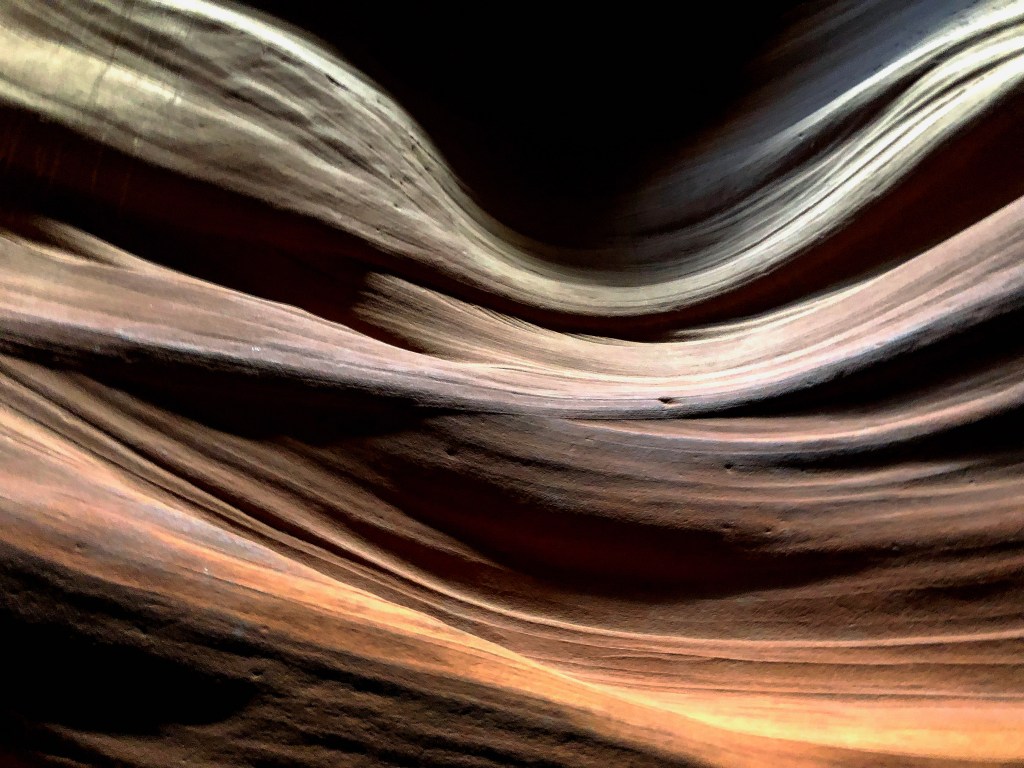
The anchor for our trip was one of the shortest, yet most beautiful, hikes we will ever enjoy: a walk through the Upper Antelope Slot Canyon. Its popularity and location in the Navajo reservation require one take a guided tour with a licensed operator. Months ahead of time I opted to book with the company founded by the late Ray Tsosie. I knew we would prefer a mid-day tour so that hopefully sun rays would penetrate into the narrow canyon for memorable photographs.
At 10 a.m. we dutifully showed up at the tour store, a converted gas station in downtown Page. We checked in and waited to board one of the old pickups outfitted with passenger benches in its bed for the ride from downtown Page. Our guide was Leonard Nez, a tall Navajo with a dry wit. He took our tickets as we boarded with a group of German tourists and told us to hang on.
He meant it. We cruised the 4.5 miles to turn off Highway 98 at a wide and dry section of Antelope Creek’s bed. Then we had a very bouncy and fun three-mile ride along the sandy creek bed to where the creek cut a 500-foot long narrow slot the Navajo call Tsé bighánílíní, which means ‘the place where water runs through rocks’. When we pulled up at the entrance to the canyon, Leonard got out, and with black humor, silently pointed and counted his jolted passengers to see if anyone had fallen out along the way.
Rainwater, especially during monsoon season from mid-June to late September, collects in the Antelope Creek basin above the slot canyon sections. Its velocity and sand load increase as it rushes into the narrow slots, eroding passageways. Another similar short section of canyon farther downstream, the Lower Antelope Slot Canyon, can also be toured. That part is longer than the Upper Canyon, and narrower in spots, with some uneven footing and has five flights of stairs, while the Upper Canyon is a smooth and level walk with more frequent sunbeams.
Leonard ensured we had no packs. Some folks in the past spread cremation ashes in the canyon, requiring that it be closed so a medicine man could bless and cleanse it. Flash flooding also closes the canyon, of course, and a 36-hour flood in 2006 kept the Lower Canyon closed for months; 11 tourists died there in 1997.
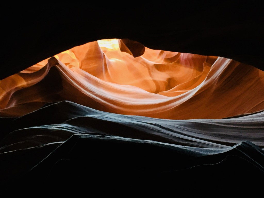
Our visit, however, was sunny and hot with no rain. It was a relief to enter the canyon’s shadows, with Leonard rapidly taking and setting each of our cameras for better shots.
The beautiful smoothed sandstone walls rose high above our group, and Leonard began stopping and using a laser pointer to help us imagine bears, famous profiles and faces, and other animals from the undulating shapes and projections. We passed a tree limb that had been stranded high up on the walls for many years after it was deposited by a flood.
On the rapid return through the canyon to the truck, I took Leonard’s advice to silently and discreetly duck behind one of the photography tour groups so I could get a nice shot of one of the light shafts.
Our group of Germans with a couple of Okies boarded the truck to bounce our happy way back to Page. This brief but memorable experience was Wendy’s favorite part of our trip.
We returned to Gone West for lunch before heading out on a 4.5 hour 270 mile journey east and north to Moab, Utah where we would visit Dead Horse Point and drive along a beautiful stretch of the Colorado River.
The highlight of our trip would come at the lowest point in our looping journey: a walk through the Antelope Slot Canyon near Page, Arizona. So we needed to make our way south out of Utah down to the Glen Canyon Dam which impounds Lake Powell. The terrain meant we would have to drive a long arc west, south, and then back east.
Scenic Highway 12 continued to impress as we traveled west toward Bryce Canyon. A few small towns dot the arid Bryce valley. After we found that Foster’s Family Restaurant in Bryce was now the UpTop Steakhouse and only open in the evenings, we backtracked to Tropic for lunch at Rustler’s Restaurant.
Tropic was named by pioneers seeking to promote it as a more temperate location than its competitors. In the late 1880s, the Mormon farmers in the area diverted water from the East Fork of the Sevier River into the often-dry Paria River drainage to irrigate their fields. They dug, mostly by hand, a 15-mile ditch which still runs today. We saw the Sevier River’s water flowing through the Tropic Ditchnear the Mossy Cave Trail at the north end of Bryce Canyon.
The surrounding hillsides had the characteristic look of the famous eroded amphitheaters of Bryce Canyon National Park a few miles to the southwest, which nature carved out of the pink Claron limestone of the Paunsaugunt Plateau. Unlike the Grand Canyon, Bryce was not carved by flowing water, but instead by frost-wedging and chemical weathering.
For 200 days a year the temperature cycles above and below freezing in that area of Utah. During the day, melt water seeps into fractures only to freeze at night, expanding by 9%. The ice exerts a tremendous pressure of 2,000-20,000 pounds per square inch. Over time this “frost-wedging” shatters and pries rock apart. In addition, rain water, which is naturally acidic, slowly dissolves the limestone, rounding off edges and washing away debris. This creates fins of rock jutting out from the cliffsides, which then erode into free-standing hoodoos.
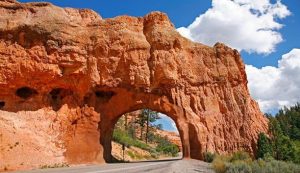
Road Arch at Red Canyon
We shopped for trinkets in Bryce and then continued our journey west. A dozen miles across the northern end of Bryce Canyon, Highway 12 runs through Red Canyon, the western edge of the valley, with its own erosion of the Claron limestone. The road passes through two manmade arches in the rock, which were fun to drive through.
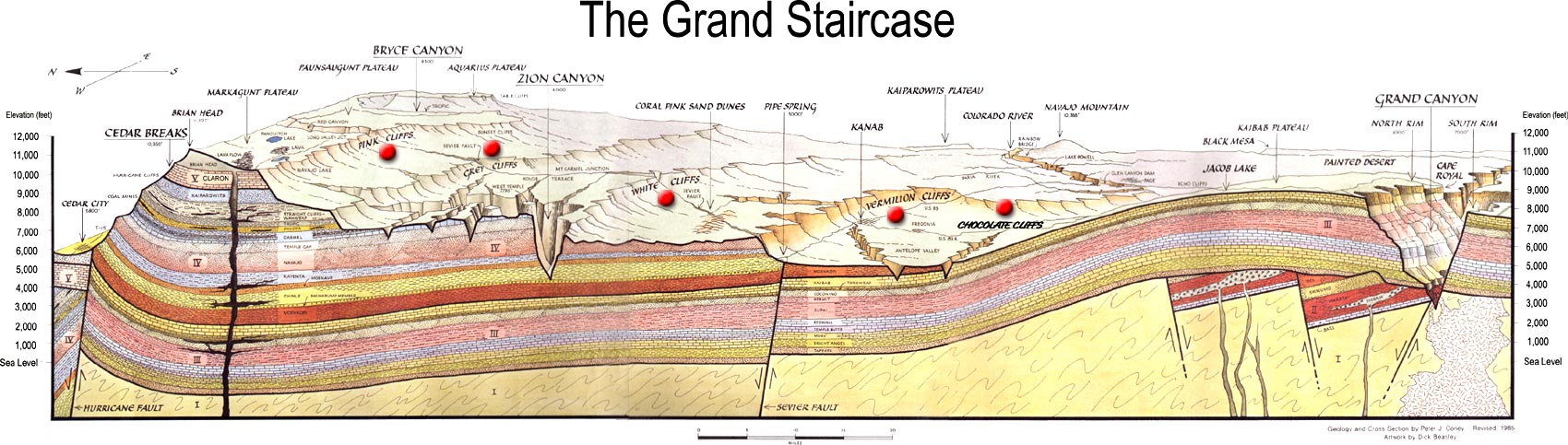
Too soon we left Highway 12, and the rest of the drive to Page was uneventful. We followed highway 89 down the Grand Staircase, a term Clarence Dutton coined for the steady descent, layer by layer, through the sedimentary rock formations from Bryce Canyon south to the Grand Canyon. The pink cliffs of Bryce give way to grey, then white, and eventually the Vermilion Cliffs we had driven by the previous summer, ending in the chocolate cliffs that form the top layer of the Grand Canyon.
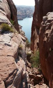
The high desert we drove through heading back east in far southern Utah towards Lake Powell was quite inhospitable. It became even more desolate as we dipped south into Arizona. It would never occur to one to stop and stay in Page, Arizona were it not for the formidable Glen Canyon Dam and associated natural and man-made wonders.
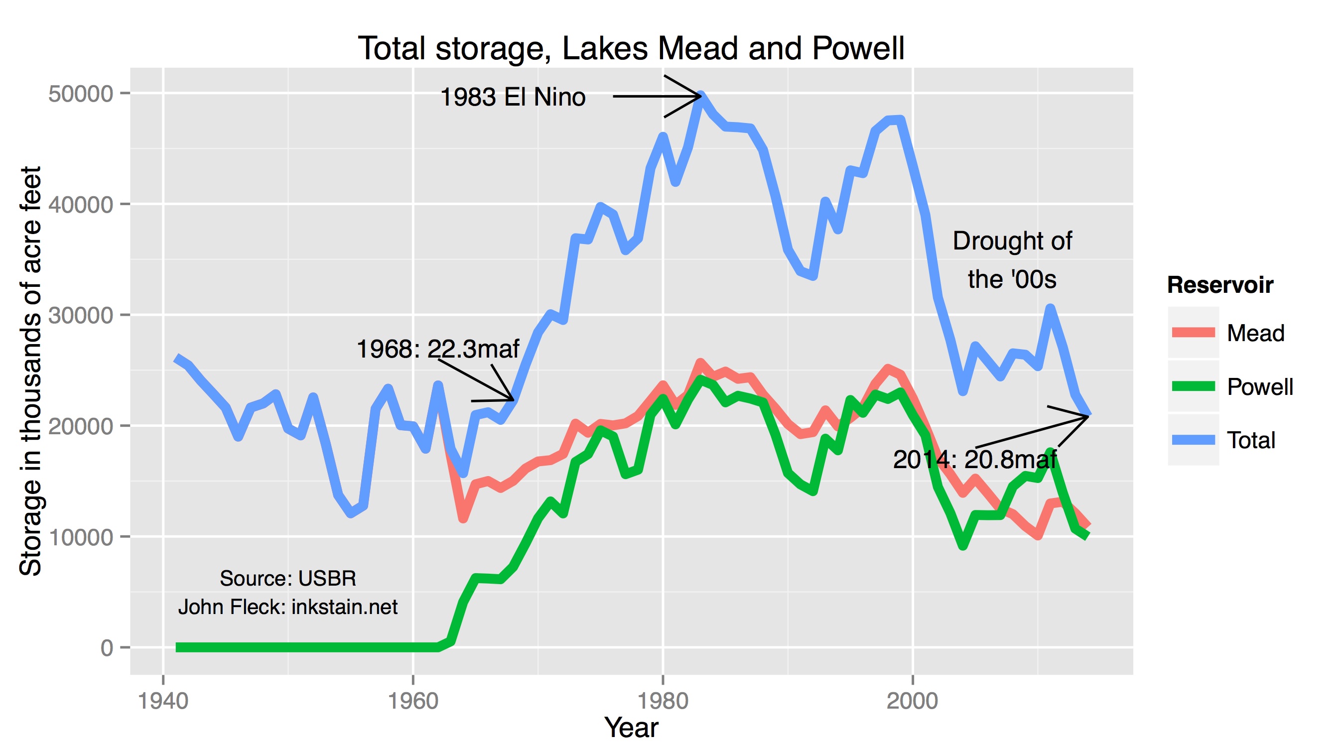
Lakes Mead and Powell have not recovered from the drought of 2000-2005
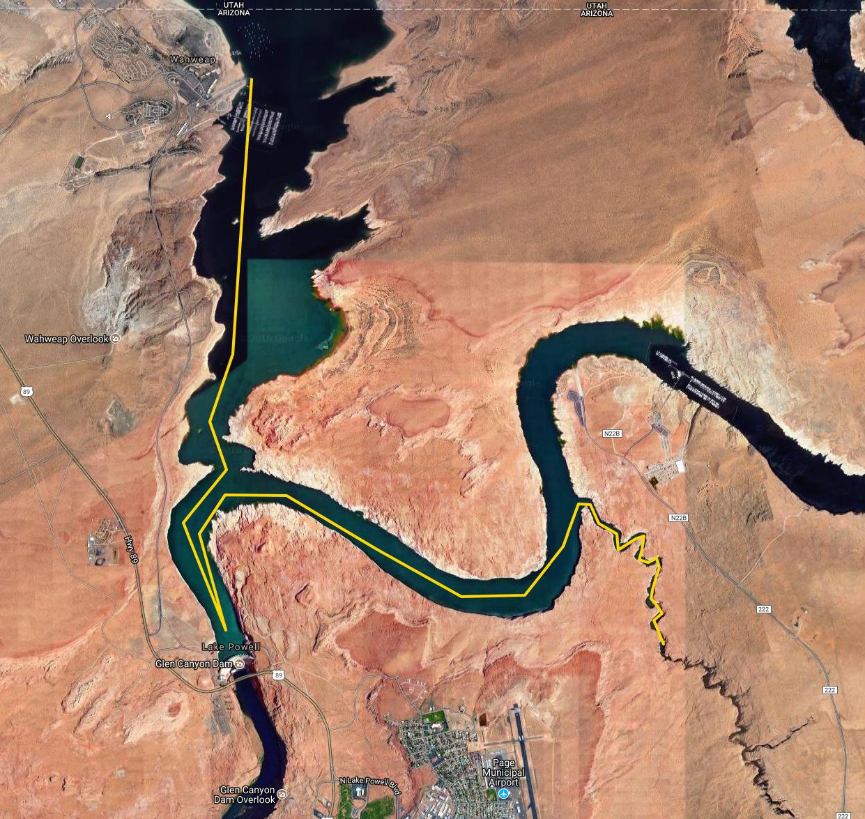
We were glad to arrive at the Days Inn in Page, where we had a nice dinner at the Gone West restaurant. The next morning we drove to the Wahweap Marina for an Antelope Canyon boat cruise. Wahweap is a Paiute word meaning “bitter water” and dates back to when the mineral-laden trickles of water in the area were unattractive. Now all that and much of Glen Canyon is subsumed under the cool clear waters of the lake.
There was quite a crowd in the marina waiting to board the boat, hiding from the brutal sunlight outside. We sat on the upper deck by a retired couple from New Jersey. They were fun to visit with and in the middle of their own adventure out west with some other retirees. I wore my Tilley hat, of course, but made the mistake of wearing shorts and forgetting to protect my legs with sunscreen. The heat and sunlight were intense, leaving me with an itchy sunburn by the end of the 90-minute cruise.
The weathering in some places exposed the layers of sedimentary rock, created hoodoos, and in spots yielded bright orange sand. There were quite a few houseboats on the lake, although for me the intense heat and sunlight, with little vegetation, left me with little desire to linger.
We returned to the marina and struggled to cool off inside the resort before heading back to Page. That afternoon we laundered clothes, and I bought some aloe vera gel for my sunburned legs. The next day we would revisit Antelope Canyon via a guided walking tour through its upper slot canyon.
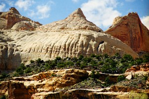
A reef sounds rather out of place in this dry desert land, but locally it refers to a rocky barrier to land travel just as ocean reefs can bar travel on the sea. The national park is a thin strip of land running north-south which encompasses the Waterpocket Fold, a 100-mile long monocline which is an S-shaped warp in the rocks likely formed as continental plates collided to create the Rocky Mountains. Pools in the eroded rocks capture rainwater, and a colorful section near the Fremont River is called Capitol Reef because of white sandstone dome formations that resemble the domes placed upon many capitol buildings.
Capitol Reef viewed from the International Space Station
We didn’t have time to explore or hike in the park, but did drive over to its northern entrance to take in Panorama Point and the Goosenecks Overlook. Highway 24 runs along the base of the stacked red layers in the Mummy Cliffs. A side road took us to a parking area, with a short slickrock trail leading up a rise for the views. Slickrock is smooth, weathered sandstone which sheds water instantly and can be dangerous to hikers as well as horses wearing iron shoes, but is fine for bikes and jeeps. In this area, the sandstone was either slickrock or heavily pockmarked.
Wendy patiently waited while I scampered about taking in the vistas atop the slabs and ridges of sandstone. Then we drove to the Goosenecks Overlook, where she shied away from the quite windy overlooks 800 feet above Sulphur Creek. Over the past six million years the creek has cut its winding way deep into the rock.
Sulphur Creek has cut through the Moenkopi Formation of mud and sand from shallow seas and floodplains of 245 million years ago, on down through the Kaibab Limestone deposited in shallow seas 270 million years ago and which is the top layer of the Grand Canyon 160 miles to the south. The creek has further penetrated to the White Rim Sandstone formed from coastal sand dunes 280 million years ago. This carved layer cake of deposition is quite beautiful, but we were both drying out in the hot dessicating wind.
So we were glad to hop back into our Ford Fusion for the drive along Highway 12 towards Escalante. We found relief from the heat as we drove from the desert up into the forests of Boulder Mountain, climbing from 6,300 feet to over 9,000 feet through large stands of aspen, pine, spruce, and fir. The Larb Hollow Overlook provided a view of the Henry Mountains, the last mountain range to be added to the map of the United States back in 1872. 350 bison roam freely there, one of only three free-roaming and genetically purebred herds left on our public lands. We could see the Lower Bowns Reservoir in the distance as well as jutting rock formations.
The road descended from the mountain to the town of Boulder, and then ran along the Hogback, a razorback ridge of slickrock high above Calf Creek to the west and Boulder Creek to the east. We stopped after that impressive if somewhat harrowing drive to view Calf Creek’scanyon.
It was late by the time we passed through Escalante and reached Slot Canyons Inn, where I had rented the Moonrise Casita while a wedding party had commandeered the remainder of the inn. We were truly remote, with no reliable internet or cell service. That remoteness frustrated our news routines, but did provide dark skies which we could view from the entry deck’s recliners. Wendy treasures privacy and fashioned a blind of paper towels for one high window. I thought she was being a bit paranoid until later in our stay when a small drone buzzed about overhead. Those darn paparazzi follow us everywhere! 🙂
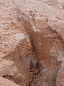
We were not tempted to continue down Hole in the Rock Road to its canyons, instead struggling back north along the 12 miles of rough road to Escalante. Along the way I pondered how the road gets even rougher if you turn south for the 50-mile journey that ends in the Hole in the Rock itself at Lake Powell.
In 1880, an expedition of Mormons trying to settle in southeastern Utah widened that narrow crack in the canyon rim above the Colorado River to reach a ford. The drop to the river was nearly 2000 feet with an average grade of 25 degrees, although some places were as steep as 45 degrees.
Construction of this passageway was very difficult, plagued by lack of wood, forage for cattle, bitter cold, and diminishing food supplies. Blasting powder and picks were used to widen and/or fill various sections of the crevice. At the lower part of the Hole, a road was constructed on the side of a sheer cliff wall. Although a three-foot shelf had already existed, an extension to the shelf was formed by driving two-foot stakes into the rock and piling vegetation and rocks on top. This portion of the trail was nicknamed “Uncle Ben’s Dugway” in honor of its engineer, Benjamin Perkins. After six weeks of picking, chiseling, drilling, blasting, and digging, the Hole-in-the-Rock road had been completed. Even after they finally crossed the Colorado, the pioneers had another 120 miles of arduous travel before they reached Bluff, Utah.
Hikers at Hole in the Rock above Lake Powell
One-third of the Hole in the Rock slit now lies beneath the waters of Lake Powell. The Hole was only used for a year before the settlers shifted the route a few miles over to the better Hall’s Crossing. The incredibly rough “modern” Hole in the Rock Road to the area is one of the most traveled in the monument, but is still hellish despite being graded 20 or more times each tourist season.
The terrain in this region is unforgiving. Later in the week Wendy and I would take the modern route 191 through Bluff as we traveled from Page, Arizona to Moab, Utah. The modern roads make long sweeping arcs to avoid the rough mesas and canyons on either side of the Colorado River.
Upon returning to Escalante, we purchased the most normal food we could find at a hipster grocery. We had already sampled the two major restaurants in town. We had a kindly server at the Circle D while the best thing about Boots Cafe was its large taxidermied bear.
This was the most remote area we visited during our vacation. The lack of services and sparse population allowed me to fully relax, knowing that I was truly away from work. Both Wendy and I preferred to avoid the crowds by shunning the pay areas of the multiple national parks along our route.
The next phase of our trip would take us past Bryce Canyon down to Lake Powell in Arizona, where we would take a sunny boat tour and a shaded guided walk through a picturesque slot canyon.