
Alsea Falls (click for slideshow)
I woke up today and had a hearty breakfast at the Agate Beach Inn’s Starfish Grill. Lots of driving today, since I headed over 70 miles inland to visit Alsea Falls and Green Peak Falls.
I drove east on Highway 20 until I reached Burnt Woods and, despite that fearsome name, turned off onto forest roads towards Mary’s Peak, the highest peak in the Oregon Coast Range. I saw almost no one for miles, making me a tad nervous as Trixie, my V7 GPS navigatrix, guided me from one gravel road to another. But the mountains gave Trixie fits and I hadn’t brought my Oregon Gazetteer (cursed airlines and their luggage weight limits), so I wound up on the wrong side of the peak facing a signpost that warned me I was on corporate land (as if I couldn’t tell from all of the ugly clear cuts) and could not continue without permission. Being a good little boy, I retreated, muttering to myself that it was too cloudy for good views anyway. At best I was being respectful of property ownership, but in fact it was a failure of courage. There was no phone service out there, but later I reconstructed my wanderings with Google Maps.
Trixie steered me onto the Tum Tum Road, which reminded me that it was approaching lunchtime. So I drove back onto Highway 20, past Philomath and into Corvallis. My breakfast had been so large and late that I wasn’t all that hungry, so I used Yelp to steer me to Le Patissier, a French bakery owned by Didier and Trinidad Tholognat. With names like that and my only French being a week of instruction in the fifth grade, I wasn’t surprised that I could barely decipher what was on offer. But the Pain Au Chocolat in the display case beckoned and I was relieved to discover that it was a variant of the croissant with a chocolate strip in the middle. I’d navigated to Yum Yum Road.
I drove on to the true goal for the day, the Alsea Falls Recreation Area. This is a remote location with few signs and several wild drivers with the Bureau of Land Management who careened by me on the curves in their pickups. What with my Hawaiian car license tags I’ve been saying “Aloha!” to other drivers, but with these guys all I could manage was “Whoa!” before they disappeared into the dust.
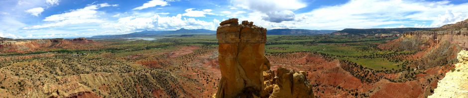
Alsea Falls drops perhaps 100 feet along the south fork of the Alsea River, although that is broken up into multiple smaller falls at this time of year with swimmers taking advantage of the reduced flow. I took a shot of the upper falls and then went downstream where I could move out into the flow, courtesy of my waterproof hiking shoes, for a snapshot or two and a panorama.
I hiked about five miles around the area, including up along Peak Creek to Green Peak Falls, which drop about 50 feet. A couple and their dog were out in the middle of the downstream flow from Green Peak Falls, so I followed their lead although I missed my trekking poles. I’d left them in the car since the trail was so gentle. Feeling pleased that my shoes were still keeping me dry, I promptly slipped on a mossy rock and fully immersed both shoes in Peak Creek. My SmartWool Light Hiking Socks, thinking I was suddenly sweating profusely, attempted to sop up the entire creek. They failed, but I got the shot.
I squished my way back to the car, where I changed my shoes, socks, and shirt. Trixie urged me to go back to the coast via “Alsea Deadwood Highway” and “Lobster Creek Road” and “Unnamed Road” and the like through the Cummins Creek Wilderness of the Siuslaw National Forest. But, tired of forest roads of dubious quality, I insisted we backtrack to Monroe and take state highways from there.
Highway 36 spun me right round, baby, right round like a record, baby, right round round round. My apologies to Ratt, but 36 was a bit tedious as it wound its way slowly toward the coast with hardly another car in sight. I was glad to finally hit 126 where the road improved (and of course the traffic increased) as it paralleled the Siuslaw River to the coast.
Highway 101 rides the coastal cliffs from Florence north to Yachats. One magnificent mile upon another flew by and I passed Cape Perpetua, which I visited briefly in 2006 and will be hiking all day tomorrow. North of Yachats I reached the Fireside Motel, where I had reserved a room for two nights. This was the only reservation I couldn’t fully complete online, so I wondered what I’d find.
Only the best room with a view on the trip, I dare say. I’m sitting here in my room a few feet from the ocean next to a big window that looks directly out on the Pacific. I’m leaving the drapes open tonight so that I see the ocean first thing when I wake up in the morning. Well, after I put on my glasses. Sigh.
Yelp tried to lead me to the Drift Inn for dinner, but there was nary a parking space to be had there. So I drove to Le Roy’s Blue Whale, where I had a serviceable fish and chips and a slice of chocolate cream pie. Now it is dark, I am tired, and you have a slideshow of photos and even a movie of the waterfalls to view. Enjoy!
[Next post: Cape Perpetua and Smelt Sands: Day 7 of the Oregon Trails]


Pingback: Cascade Head and Newport: Day 5 of the Oregon Trails « MEADOR.ORG ~ The virtual world of Granger Meador