
Ha Ha Tonka (click image for slideshow)
So I was up at 5 a.m. Saturday morning to prep my trip, have a Country Breakfast at Eggbert’s, and by 7 a.m. head east on pitiful US 60 to Vinita, where I could then take I-44 northeast to Lebanon, Missouri. On the drive I listened to a technology podcast and then, to spur me onward, I listened to Meat Loaf’s thundering and theatrical Bat Out Of Hell album. I especially enjoyed the energy and tortured vocals of the live version of the title track. I’ve been reading Tearing Down the Wall of Sound: The Rise and Fall of Phil Spector, and on Meat’s album You Took The Words Right Out Of My Mouth (Hot Summer Night) was a great example of how Spector influenced others.
I wasn’t too thrilled about having to drive through Lebanon. A quarter century ago my friend Jeff and I were teenagers returning from a trip to St. Louis when my 1978 Chevy Monte Carlo started acting up on I-44 and we pulled into Lebanon for service. The car was running very rough, a coolant hose had greatly expanded but not burst, and the mechanic at the local Chevy dealer was an incompetent crook who said all we needed to do was have a friend of his cut out the catalytic converter. We knew that was malarkey, so we had to go to a different shop where they could properly diagnose the problem (failing ignition coil, as I recall). Unfortunately they only took cash and couldn’t get to the car until the next day. Noting the prospective payment for parts and labor, Jeff and I had very little spare cash, and back then we were too young to have credit cards. So we had to spend the night at the cheapest joint we could find, the memorably misnamed Bell Motel, which should of course been called Hell Motel. Here’s a postcard of what it was like when it was new, and here is what it became. When we finally were back on the road the next day I drove like a Bat Out of Bell.
On this return trip so many years later, I drove straight through Lebanon, avoiding the east side where the Bell Motel was once located. I stopped at the disturbingly named Kum & Go for some fuel for the car as well as myself, picking up a turkey sandwich I could eat out at the park. Then I drove the rural highways over to Ha Ha Tonka.
Back in 1909 Missouri’s governor proposed this area for the first state park, but it didn’t become one until 1978. As told on Conor Watkin’s website, Kansas City businessman Robert Snyder bought the area around Gunter Spring in 1904. Unlike Thomas Sayman, another businessman who bought Roaring River and then donated it to the state, Snyder spent considerable funds constructing a stone castle, carriage house, greenhouses, and water tower on the site. But he was soon struck down in one of the state’s first automobile accidents. The projects were gradually completed by his sons in a less elaborate fashion. They lost a court fight over Bagnell Dam and the Lake of the Ozarks and declining fortunes eventually led them to lease the property out as a hotel. It burned in 1942, leaving only the sandstone water tower, which was burned by vandals in 1976. Today the native sandstone remains of the castle and carriage house remain, and the water tower’s roof has been restored.
Gunter Spring was renamed Ha Ha Tonka by a land speculator, who claimed that was Osage for ‘Laughing Waters’. That’s doubtful and other sources say it means ‘Laughing Spirit’, but one verified factoid is that almost 50 million gallons of water gush out of the spring each day. The spring area features caves, sinkholes, natural bridges, and bluff shelters which are all formed from the remains of a collapsed underground cavern system.
I stopped at the park office where a perky young woman, whom I would later see out on the trail with a lucky young man, gave me a detailed trail map and pointed out various locations where I could park and then walk to the park’s main features. I declined to drive around from site to site, of course, instead parking at the central Colosseum sinkhole area where I could have a picnic lunch and then wind my way through about eight miles of interconnected trails to see everything on foot.
I enjoyed a turkey sandwich and tangelo at a picnic table at the parking lot, but the peaceful surroundings were disrupted when a group of male motorcyclists buzzed in, yakking and cursing about their bikes. They weren’t about to leave the asphalt, however, so it wasn’t long before they roared off. By then I had donned my hiking boots, sprayed down with Cutter insect repellent, slathered on some sunscreen, and was ready to head out.
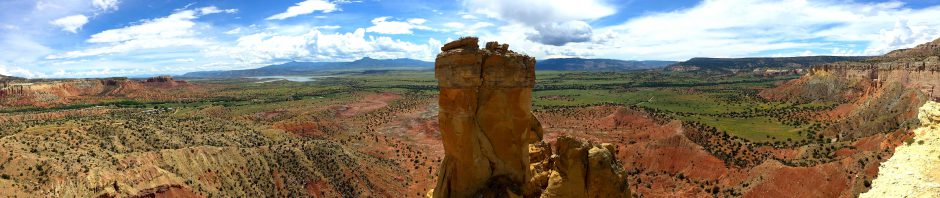
It was only a short walk to the large natural bridge, which I walked under, the ceiling many feet above my head. The trail led on through the Colosseum sinkhole, which has steep sides and is 300 by 500 feet. A later gap in the trees provided views of the Castle Ruins and Water Tower perched high above the chasm of the Ha Ha Tonka Spring below. Winding my way above and around the spring I was provided repeated views of the Water Tower. I’m glad they’ve repaired the roof, as this is a striking building on the hillside, its eighty foot height allowing it to jut above the trees. The early afternoon sun provided a nice contrast of light and shade on its native sandstone, and lit up the interior through openings in its thick walls. Originally the large tank was at the top of the tower, with living quarters below that for property employees. That explains why a water tower would have a chimney, but I’m not sure I’d sleep well with thousands of gallons of water perched above my head all night.
I passed the remains of the stables and carriage house, which burned at the same time as the Castle. Then I saw the eerie eastern facade of the Castle Ruins. Families were strolling around the grounds, snapping photos of each other against the ruins. We could see the surviving interior walls and foundations, and the southern facade featured a walkway beneath the buttresses. On the south side of the ruins was what I presumed to be the remains of a fountain, with a nice view of the Lake of the Ozarks to the west.
I then took the Quarry Trail, which looped northwest of the ruins. Turkey vultures circled overhead, no doubt roosting on the 250-foot high bluffs below the ruins and above the spring. I was listening to a Hercule Poirot mystery on my iPhone, and found it more interesting than the shallow quarry where the stones were harvested for the buildings. Then I went back around the spring and down the trail to its mouth.
This spring is not as photogenic as the smaller spring at Roaring River, but you can sense its power in the heaving surface of the water gushing out into the Lake of the Ozarks. Far above I could see the ruins. Soon I came upon a large island, which had a perimeter trail passing by “balanced rock”, an unprepossessing dolomite boulder perched near the west end of the island. Circling around to the north side of the island I found the massive bluff towering overhead and a father and son fishing where the cool flow from the spring mixes with the lake.
Walking upstream on the northern flank of the island I admired part of the spring’s flow across some rocks and reached the narrow barred entrance to Island Cave. You can get a permit to explore this cave and another one if you have a hankering for narrow dark holes. I happily stayed in the sunlight, strolling off the island over to the Boulder Ridge Trail, although I found a large tree fungus more interesting than the namesake lichen-covered stones.
I then returned eastward on a different trail branch, past the Ha Ha Tonka Post Office. This stone building was operational from 1872 to 1937, and I was struck by how little clearance there is between its front step and Highway D through the park. I shot a passing pickup to illustrate why this post office wouldn’t meet modern safety standards!
I then strolled by a large concave bluff wall, called Devil’s Promenade, which had some tricky trail footing and led to the Devil’s Kitchen sinkhole and cave shelter. This small cave had a skylight in the rear which I photographed both from within the shelter and from up on top. Yet another parallel to Roaring River, which has its own Devil’s Kitchen, although that nicer rock shelter partially collapsed in my lifetime and is not as inviting as it was in my youth.
The outstanding feature of my final trail segment, the Acorn Trail, was a section of eroded bluff. Over the course of a few hours I had travelled 7.8 miles on the Colosseum, Dell Rim, Castle, Quarry, Spring, Boulder Ridge, Devil’s Kitchen, and Acorn trails. I saved the 2.5 mile Dolomite Rock trail and the 6.5 mile back country Turkey Pen Hollow trail for a future visit. Perhaps I’ll spend a weekend in the area and take them along with some trails at nearby Bennett Spring.
I was quite hot and sweaty by the time I returned to the car, so I stripped off my shirt and washed up. Finding the parking lot deserted, I took the opportunity to hop in the car and discreetly change out the rest of my clothing. Wearing fresh duds and with the air conditioner running full blast, I headed back toward Lebanon. I then zipped down I-44 to Springfield. I was surprised at all of the new development on the southeast part of town, no doubt driven in part by the entertainment boom in nearby Branson. I stopped in a T.G.I. Friday’s for a surprisingly good dinner and then headed home. I’d left Bartlesville at 7 a.m. and was back in town before 10 p.m. after a great day trip. I eagerly look forward to more of these during the all-too-brief autumn season.


