
Roman Nose State Park (click image for slideshow)
November 15, 2010
I have visited Roman Nose State Park, situated a few miles north of Watonga, Oklahoma, on multiple occasions. Watonga is famous for its cheese, although the remnants of Hurricane Erin back in 2007 blew away the cheese factory which had operated there since 1940. Just recently the factory reopened, but sadly it is now located in Perryman, Texas since that town offered a financial incentive.
My most vivid memories of Roman Nose are from a camping trip my friend Jeff and I made there over two decades ago. We went up a trail and decided to head cross-country downhill rather than make a long loop. Big mistake – the hillside was littered with hidden cacti and my feet and legs took a beating. I think it was on that same campout that we got so cold in our tent that we gave up and drove over to the lodge and rented a room to warm up!
On a mid-November Sunday morning I breakfasted in Oklahoma City with my father and then drove out to Roman Nose. My Oklahoma Hiking Trails book recommended a 6.25 mile loop around the edges of the park, and I followed that plan with a small deviation to avoid repeating part of a trail. As for the lodge, it sits down on its own drive down by Boecher Lake and I only saw it from across the water on this trip. A Daily Oklahoman newspaper article that same morning indicated the lodge had been renovated, but I was far more interested in the trails.

Roman Nose Park Entrance
Entering the park I saw the striking and familiar sign of an American Indian with a Roman Nose. Arkansas has erected beautiful three-dimensional painted signs at each of its state parks, and Oklahoma has at least one park with a memorable sign. The park is named for Henry Roman Nose, a Cheyenne Indian Chief who owned the 600 acre allotment that encompasses the present-day park. He wintered in his tepee in the canyon from 1887 until his death in 1917, escaping the cold winds up on the plains.
I drove past the golf course and lodge drive and turned to pass the general store and travelled up the western shore of Boecher Lake and adjoining Watonga Lake. There were several people in the campgrounds and a number of fishermen out on Watonga Lake. At the end of the drive I parked beside the trailhead for the Lake Loop, shooting a photo of the park’s trail map sign with my camera since it provided more detail than the one in my hiking book. I should have shot that sign with my iPhone instead of my Panasonic superzoom camera, as it is easier to zoom and scroll images on the iPhone’s display.
Just to the left of the trail was a steep hill. I took a rough side trail to the top to get a nice view of Watonga Lake. I could see a boat along the shore near the earthen dam, with the lake surrounded by eroded mesa walls. Then I clambered back down to the trail and followed it across the dam. There I had a nice view of a fisherman out enjoying the placid water.

Fisherman on Watonga Lake
After crossing the dam, the mown grass led me past the base of Inspiration Point, the highest point in the park, and led (or misled) me back around to a field on the east side of Bitter Creek before suddenly ending in a loop. I’d noticed a branching trail a ways back, which must have been the intended route.
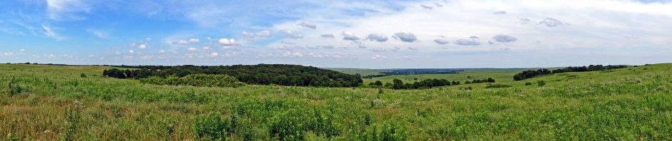
So I backtracked a bit and took the side trail, which wound around the northeast side of Inspiration Point. This section of trail, like many others, is open to horses. I tried to dodge their deposits but as I took a switchback up the east side of the hill toward Inspiration Point I kept smelling horse manure. Sure enough, I’d managed to get some on my boots and I was hard pressed for awhile to find a suitable surface or plant material to rid myself of it. The hillsides were covered with red cedars and eventually I had reached Inspiration Point for a panoramic view of the lake and dam below and the gap in the mesas where Bitter Creek runs northeast to eventually join the Cimarron River, changing its name to Salt Creek along the way. Through the gap I could see the white gleam of grain silos scattered about the landscape.

Bitter Creek Gap
From the peak I could see a housing development crouched on the hillside just above the park boundary. The entire park is only 540 acres, so it was practical to circumnavigate much of it by trail in a few hours. It has an interesting history. What I’ve pieced together is that the road I had driven to the trailhead was once the railroad bed for tracks that led to a gypsum mining operation that was once located right where Lake Watonga is today, with employees living in the ghost town of Bickford a mile or so to the northeast. Bickford died out in the 1920s and John Buell Cronkhite and his brother, Cap, designed and began building a recreational facility in the canyon in 1925. They were sons of Will Cronkhite, who owned the Bitter Creek Ranch adjoining the area to the west. The family constructed a forty-foot dam to form a 15 acre lake that was 35 feet deep at the dam. However, a tragedy occurred on June 17, 1926 when Loree Cronkhite drowned in the lake. The family abandoned development of the resort and in 1935 sold the park site’s 540 acres to the city of Watonga, which in turn gave the land to the State Parks Department. Officially titled Roman Nose Resort Park, it was one of the original seven Oklahoma State Parks, constructed by the Civilian Conservation Corps and opened to the public in 1937.
Leaving Inspiration Point, I followed a trail along the park’s eastern boundary with a canyon stretching out along my right. Eventually it dipped down into the canyon’s trees and then popped back up to the rim, making a series of switchbacks along the park’s southern border. Sometimes the path crossed extensive patches of cacti jutting out from the gypsum rocks, looking just as sharp as I remembered from the 1980s. At one point a ghostly white deciduous tree stuck out in the canyon below, surrounded by cedars. The trail eventually passed by a cave-in where a spring had undermined the gypsum beds.
Eventually the trail ran back north to Boecher Lake and I visited a scenic lookout I remembered from years back. I could see colorful paddle boats, which I was tempted to commandeer for an unauthorized excursion. Off to one side of the trail was a hidden side outlet where Boecher Lake feeds into Watonga Lake.

Boecher Lake Outlet
I took a trail across the Boecher Lake dam for a panoramic view across Watonga Lake. I passed a miniature golf area. Its vine-covered trees and odd figurines helped make the scene a tad eerie without children scampering about.
I brought the 6.3 mile hike to a close after three hours, feeling famished. So I drove an hour northeast to Enid for a late and, unfortunately, lamentable lunch at its El Chico. They no longer had El Chico’s “old way” queso available at this franchise, only proferring a thicker complimentary queso that was quite inferior. I then zipped back to Bartlesville to end the weekend with laundry duties. Next weekend I hope to make another day hike, perhaps to Missouri or Arkansas, weather permitting.


Pingback: Charon’s Garden « MEADOR.ORG
Meadow is a pedantic.
How ironic. *Meador
Pingback: Roamin’ at Roman Nose | MEADOR.ORG