
Yellow Rock at Devil's Den State Park (click image for slideshow)
I had a Silver Dollar breakfast at Eggberts and dawn was breaking as I drove down US 75 to Tulsa, then heading due east on 412 to Fayetteville to catch the I-540 bypass south to the park. Arriving at the visitor center before 10 a.m., I picked up a trail map, but it had no more detail than what I’d already found online. I planned to hike four trails in the park, making several loops for a total of six or seven miles. I first hit the nearby Devil’s Den Nature Trail which sports several geological formations. Fellow hikers, including some of the fairer sex in colorful regalia, were in evidence. But I often had areas of the trail to myself, including the Devil’s Den area with its eroded sandstone bluffs with their many layers, some lichen, and sealed caves. The area was very rocky and treacherous both due to slipping rocks and the many leaves covering them – I made heavy use of both trekking poles and still managed to tumble once onto my rear.
Returning to the main trail, I ascended to another sealed cave where a series of wide crevices have opened up. I decided to go off the main trail to see more of them, ascending to the top of the mountain into a wilderness area where I found crevices with crisscrossed trees, crevices with mossy walls, and a crevice topped by a felled tree trunk. I then bushwhacked in a large circle to return to the main trail, which had a crevice running alongside it and a right-angle crevice which is near one entrance to the Devil’s Ice Box, a now-sealed cave which pours out a stream of cool air blown through it from above.
The trail then wound past bluffs with heavy bowl erosion patterns. The many large stone steps were clearly the blessed work of the good old CCC. Eventually I reached the Twin Falls area, although it was too dry to see much. The large upper falls area did have some drips. One of the most fascinating parts of this trail was the building-sized hunk of eroded sandstone which reminded me of the Casa Milà in Barcelona by Spanish architect Antoni Gaudí. Bowl erosion had formed various portholes and tunnels through the stone. The trail eventually wound back down the Lee Creek, which created the valley the park occupies. There I found a few ruins at the location of the old Donald homestead.
Having completed my first trail I decided to set off south down the west side of the creek along the Lake Trail. The CCC built a dam to create the eight acre Lake Devil along here and there was a low-lying building near the north edge of the lake which was quite picturesque. The big rock dam was interesting and climbable. Some boys were fishing from one end and I enjoyed scrambling over to the spillway to get a close look at it. A statue of a CCC worker had been erected nearby.
Then I was off along the shore of Lee Creek. The Lake Trail became the Woody Plant Nature Trail as it wound by a campground. A large bluff drew me down to the creek and nearby I saw a fellow traversing the creek via a suspended line, cheered on by onlookers. Farther on I found a spot where a huge slab had fallen beside the creek and took advantage of a convenient rock as a lunch spot, dining on a turkey sandwich I had bought on the road. I took the time to snap a self-portrait and then, rather than retrace the lake trail back to the other trailhead I wanted, wound my way uphill along Highway 170 up to a CCC overlook.
Far below I could see the bridge in the heart of the park which I’d crossed earlier to reach the west side of Lee Creek. The Yellow Rock Trail ran from the shelter northeast along and down the mountainside. There were some nice eroded bluffs and I was delighted to see my shadow as the sun finally broke through the overcast which had lingered all day. Perfect! I scampered down sunlit steps, knowing I’d have good light when I reached the famous Yellow Rock Overlook. I’d saved it for the end of the hike so the sun would have more time to break through.
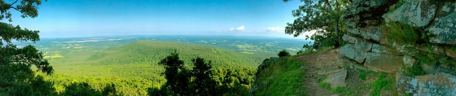
The overlook was larger than I’d expected and I faced north to shoot the famous Yellow Rock itself with both my regular camera and my iPhone, as well as in a panorama. The side of the mountain was dotted with trees bearing the final remains of autumn. I had plenty of company at the overlook, including a fellow who lay down facing the edge. But not wanting to interfere with other shutterbugs, I waited until all the other hikers had vacated the area to venture out on the rock for a self-portrait, although my timer didn’t last long enough to get a side shot. The view was tremendous, and the view south was spectacular as well. Farther along the ridge I saw a twisted cedar and bluff crevices. The remainder of the Yellow Rock Trail back to Lee Creek was also scenic, with bluffs viewed from overhead and some nice overhangs above the trail. One section of bluff had Halloween rocks of black and orange.
I’d hiked about 6.75 miles by then and was ready to call it a day. So I drove back to Tulsa for dinner and just managed to beat the evening crowds at Zio’s and get a table without waiting. I then drifted through a Borders for book ideas – bless them, Amazon is eating their lunch and I’m not helping, using the Tulsa bookstores to browse but then purchasing books on my Kindle.
Thanksgiving Break approaches, but I don’t know yet if my schedule will allow for more day hiking then or not.


Pingback: Hiking the Devil on Sunday « MEADOR.ORG
Pingback: The Trails at Devil’s Den & Crystal Bridges « MEADOR.ORG
Howdy would you mind stating which blog platform you’re using? I’m looking to start my own
blog soon but I’m having a hard time deciding between BlogEngine/Wordpress/B2evolution and Drupal. The reason I ask is because your layout seems different then most blogs and I’m looking for something completely unique.
P.S Sorry for getting off-topic but I had to ask!
I use the Choco theme on wordpress.com.