
Above Quanah Parker Lake (click image for slideshow)
I paid the price for too many colas at yesterday’s supper: a sleepless night in my room at Quartz Mountain. I finally drifted off and did not get up until 8:15 a.m. A cold shower woke me up, but not by choice. The hot water was malfunctioning and while the water wasn’t frigid, it was uncomfortably chilly. I had a hot breakfast in the Sundance Cafe and overheard other diners mentioning the chilly start to their day, so I wasn’t the only one who had suffered.
I packed out and headed to Granite at the opposite end of Lake Altus. Granite is known for two things: granite markers and a state reformatory. Which to visit? Let’s see…

Will Rogers in Granite
I found Willis Granite Products fittingly located at the intersection of Mountain Avenue and Quarry Drive. They extract from Headquarters Mountain and beside the entrance they’ve erected a likeness of Will Rogers comprised of 195 granite panels. Entitled “Giants of the Plains”, it points to missing likenesses of Sequoyah and Jim Thorpe, which were mentioned in a 1980 edition of Oklahoma Today but never constructed.
There is also a fake cemetery, or “cemetary” as shown on its sign, created from tombstones created by the Willis firm for a Texas veterinarian and his wife. After retirement they eventually opted to have the stones returned to the quarry from which they came. I liked Penelope Prichard’s epitaph: Life is like a piano. What you get out of it depends on how you play it. There were stones for the satisfied woman, several with sayings of Will Rogers, a plea from a widow woman yearning for comfort, among many others.
As I left town I passed the reformatory, but didn’t know of anyone there hoping for a visit from me. So I rolled on through Lone Wolf, Hobart, Roosevelt, and Snyder, making for the southwest corner of the Wichita Mountains Wildlife Refuge. Somewhere west of the Treasure Lake Job Corps Center are the remains of Ison’s Folly.
George Ison staked an 80 acre claim there in 1866 and he and his son Silas moved in permanently in 1901 as the Wichita Mountains Forest Reserve was being established. Silas had married Dove Murray, sister of the Oklahoma Governor “Alfalfa” Bill Murray. The Isons fought the U.S. government to remain on the 80 acre plot and George died in the 1930s. Silas continued to work the area and in the 1940s was finally awarded “squatter’s rights” for the remainder of his life, which worked out to about 30 years since he died in 1972. He and his father established four mines: the Atlas, Old Maid, Mennonite, and Half Moon. They sunk 13 shafts on their property and built a stone walkway up a stream from a stone cabin to a hand-built rock dam. My goal was to locate the remains.

My search for Ison’s Folly
Edward Charles Ellenbrook’s book mentioned a faint trail off the Indiahoma Road near the southwest edge of the refuge. I first tried bushwhacking close to the boundary, but in traipsing about for almost 1.5 miles all I found were buffalo and erosion. Figuring I’d missed the spot, I drove on eastward and parked, backtracking and pacing off the distance from the Job Corps center. There were many animal trails, so I just followed one and rambled all over the wooded area streams searching for any signs of the Isons.

A ha! Found the walkway…
Just when I was about to give up, I stumbled across a section of pipe and a drain trap. Perhaps this was from the stone cabin? I headed northwest up a stream and finally came across the granite terraced walkway. It was quite overgrown in spots with multiple treefalls. I struggled upstream and finally saw the rock dam and tiny adjacent zircon mine. What Ellenbrook’s book said was a 20 minute walk had turned into a multi-hour search.

Ison’s Dam
I clambered up for a better view of the dam and behind it found no water, as the stream flowed under the silt and out from its base. Climbing higher up the defile I located one obvious large shaft with a tree growing out of it and farther upstream found another cutout. I climbed up its tailings pile for a closer look.
I finally stopped climbing upstream when cedar overgrowth grew too thick and backtracked to the dam. The water trickling into the pool below reminded me of a huge ripple tank. Perhaps I should haul my physics students out here to see some diffraction action.
I sat down for a snack while I enjoyed the view and shot a video:

Ison’s zircon mine
Then I bushwhacked over to the zircon mine, the front of which is now a brick wall. There was only a tiny pool behind it. I returned along the tree-strewn terrace, grateful for the clearer patches. I searched about for a large tree since Ellenbrook said the cabin remains were nearby. A newspaper article said the cabin was bulldozed in 1976.
I found a large tree but no remains thereabouts. Scouring the area I finally found a stone where someone had collected a number of bricks stamped St. Louis. This was as much Ison debris as I would find – I hadn’t waymarked the pipe and drain trap I’d seen earlier and never did relocate them. Around here a big elk zipped by along the edge of the woodland – I only saw his rump so it is just as well the camera wasn’t ready.

Being watched
I was weary of bushwhacking for hours on end and made my way to the road, happily leaving the wooded area to follow animal trails in the grassland. Longhorns eyed me warily as I traipsed back to my car. The calves tried to emulate the adults, but their attention spans were noticeably shorter. One cow eyed me from a downed fence. I don’t think it mowed down that fence, but I wouldn’t argue with it anyway.
I then drove north and east, where buffalo were entertaining drivers. I was heading for a real trail this time: the one leading up Little Baldy Mountain and over to the dam at Quanah Parker Lake.

Little Baldy Mountain & Quanah Parker Dam
I parked in the visitors area at Camp Doris. Buffalo blurred by across the road as I made my way to the unmarked trailhead. There is a true paucity of signs on these trails. The only sign I did find was almost illegible, but I could make out Stairway to the Sky, which sounded most appealing.

Steps on Little Baldy
I’d already crossed a bridge over a dry creek leading into Quanah Parker Lake and climbed one flight of steps earlier along the trail. I lost the trail to the sky stairway, so I circumnavigated Little Baldy until I spotted them. I climbed to the summit, where I found a couple of metal stakes pounded into the granite.
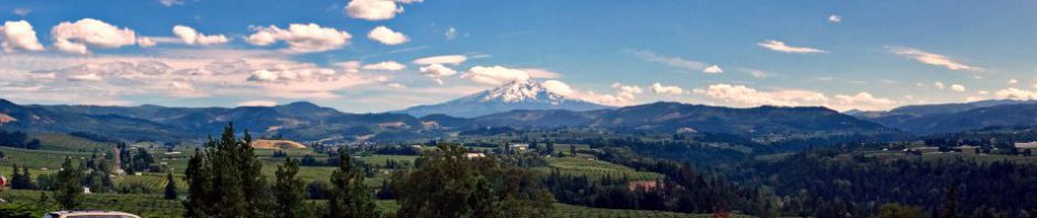
I shot a 360 degree panorama and then shot a self portrait I entitled A Little Baldy Atop Little Baldy Mountain. I also got a closer shot with Quanah Parker Lake in the background. In the distance I could see the chasm carved by Quanah Creek.
I then descended the Stairway to the Sky and made my way over to the dam. I was pleased to find it was designed with stairs and a walkway across the top. I crossed and looked back to admire how the dam was joined to the rock. I was surprised to find a small lower pool below the main dam, formed by a small downstream dam. This demanded investigation!

Quanah Parker Dam

Double dams
I clambered downslope and used animal trails to reach the lower dam. I made my way out onto a bar to get a shot of both dams along Quanah Creek and then made my way upstream to admire the reflections in the lower pool. I then recrossed the dam, following a trail over to the lake shore and used it for an alternate route back to my car, crossing a different footbridge than before.
I drove out of the refuge, stopping at the east entrance to walk uphill to the old road and the 38 foot long archway of native stone that once marked the park entrance. The west side glowed in the setting sun as I left the refuge, eager to return sometime in 2012 to explore a few more sights mentioned in Ellenbrook’s guidebook.

Old entrance to the refuge
I hiked 8.2 miles today, bringing my day hike total for 2011 to 311 miles. I might just add some more to that tomorrow as I journey back home.


Pingback: Windy Walks in the Ozarks « MEADOR.ORG
Pingback: From the Parallel Forest to the Central Peak of the Wichitas « MEADOR.ORG
I found your post re: Ison’s Dam in the Wichita Wildlife Refuge extremely helpful. Like you, I tried to follow Ellenbrook’s instructions with little success. Your yellow lines on the satellite map proved valuable. I pulled up the satellite map so I could compare. I believe the following is the simplest (??) way to find the dam. 1. Reconnoiter before parking by driving west from the Job Corp Center. North of the road as one goes W. there is a small open field then trees then a much larger field which is across the road from the small loop South of the highway where brochures can be picked up. Have a copy of Meador’s marked Satellite map and one of that area. 2. park at W entrance old Job Corp area. Walk West on the road until you get to the large field. 3. What trails there exist are small, and at places just bushwack North Staying just West of the large clump of trees. 4. At the N. end of the field just W. of the trees you will find trails that will take you down to the rocky creek (dry the day of my hike) As you go west (L when you reach the creek) you will eventually see Ison’s wall on the S. side of the creek. The creek takes you West to the dam. which is above the level of the creek. (Take Meador’s photo of dam with you) Debris from cabin (?) visible as is brick wall in front of old shaft. Tree in old shaft above the dam. Of interest Dam is slightly curved; it also has some concrete on N side. Don’t expect well marked trail or easy trek along the creek to the dam, but it’s fun to find the dam and the mine shafts. Thanks again for your very helpful post.
Glad you found it! The refuge is a great place to explore. Thanks for sharing these tips.