May 28, 2012
My third and final day of my brief foray to Kansas City would feature day hikes at Knob Noster and Harry S Truman State Parks southeast of Kansas City, closing the second half of a big loop back to Bartlesville that night. The Hampton Inn breakfast area was again packed so I returned to Denny’s for another Grand Slam and then, as I’d done the day before, headed east on US 50. This time I continued on past Powell Gardens for another 30 miles, turning south at Knob Noster. Noster is Latin for “our” so the town’s name means “our hill” and refers to two knob features in the landscape just northeast of the town, which I did not view. Instead I turned south for the short drive to the state park.
Whiteman AFB
Adjacent to the park on the east is Whiteman Air Force Base. It opened in World War II as Sedalia Army Air Field for glider and paratrooper training, later became Sedalia Air Force Base for the B-47 Stratojet bomber, and was renamed after 2nd Lt. George A. Whiteman of Sedalia, a fighter pilot who perished in the Pearl Harbor attack. The base became home to the fourth Minuteman intercontinental ballistic missile wing, with large underground bunkers and launch control centers, for thirty years. It is now the only permanent base for the B-2 Spirit Stealth Bomber, which can strike high-value targets anywhere in the world from this base in central Missouri. The large base also hosts various other air force, army, and navy units. I didn’t see any of the B-2s flying while I was at Knob Noster, but evidently aviation enthusiasts do like to camp at the state park and watch the big flying wings take off and land over at the air base.

Knob Noster Park (click image for slideshow)
Knob Noster State Park
Using a park map as a guide, I parked on the east edge of the park at the south end of the developed area, at the trailhead for the Clearfork Woodland Trail, which is actually a small loop off the larger Hawk Nest Trail. I’d spend this first visit in the park’s northeast quadrant, where the campgrounds and most of the hiking trails are located. The southeast quadrant is a golf course, while the northwest quadrant has a group camp and a newer trail shared with mountain bikes and with denser growth which has not been managed as long as the Clearfork Woodland area. The southwest quadrant has another group camp and an equestrian trail, which was damaged and under repair.
Clearfork Woodland Trail
I immediately saw some prairie roses, which would be the most colorful feature of the landscape in this area. I was on the Hawk Nest Trail, arcing through the woods toward the Clearfork side loop. I shot a full panorama of the area and followed the trail as it bobbed around one of the hollows. A butterfly posed on the trail, showing its wings, and the view across the loop was quite beautiful. Prescribed burns have helped clear out some of the undergrowth, making this a charming area with good circulation on a hot and humid day.

Hawk Nest Trail
Hawk Nest Trail
Soon I was back on the Hawk Nest Trail, heading south. This wider trail led around beautiful tall oak and hickory trees, with denser undergrowth. Sturdy bridges led over creeks, with the tall trees reminding me of some of the more scenic portions of Bartlesville’s Pathfinder Parkway. The trail climbed and curved between the tall trees and sunlight streamed across the undergrowth. The sun filtering through the trees and curving trail made this a perfect woodland hike. The park includes an orienteering courses, and I passed their starting point at a bridge, where I crossed another creek and then popped out of the woodland at the special use area, a huge clearing with a few picnic tables and fire rings as well as more prairie roses.
Discovery Trail
I walked through a picnic area and over to the campground, missing the trailhead for the North Loop at the playground but finding the one for the Discovery Trail on one side of the camp area road. The Discovery Trail is a loop trail off the larger North Loop Trail to the west. The main feature of the smaller Discovery loop is No Name Creek, which runs nears the park’s Visitor Center. The trail runs along the high bank above the creek, climbing to afford a view of the meandering creek below. I found a spot where I could climb down into the creek bed to a fallen tree and strike a pose. I walked up the creek bed a ways, and then returned to the trail and made my way around past the Visitor Center and back around the loop until I intersected the North Loop Trail.

North Loop Trail
North Loop Trail
This trail led through some creek bottomland and then up through some more pretty trees to a clearing and fire line. The park is managed to control some of the second and third growth timber of what was prairie land in presettlement days. I see plenty of prairies in Kansas and Oklahoma, so I don’t at all mind the pretty woodland of tall trees which has developed here. While I liked portions of the North Loop Trail, I preferred the Hawk Nest area.
Lake Buteo
I crossed the park road and walked down past the WPA area and a modern shelter to Lake Buteo. This pretty little eight acre lake was built in 1927 and is quite shallow. It has beaver, muskrat, frogs, snakes, a variety of fish, and even freshwater jellyfish. I suppose there should be hawks about too, since Buteo means hawk in Latin. There is a trail encircling the lake, which crosses the small spillway on stones scavenged from the crumbling walls, made superfluous on this day with no outflow. The old curving stone walls of the spillway had a significant erosion gap.

Lake Buteo
I crossed the earthen dam, enjoying the panorama of the lake, and walked southeast along the lake shore, past a tree with a large distinctive knot and on along the lakeside. I clambered down to sit on a tree which had fallen into the lake and enjoyed a snack lunch there, watching dragonflies darting about the water plants, including large skimmers constantly zooming back and forth.
Leaving my perch, I walked to the marshy southeast end of the lake, which often floods through the action of beavers. One tree had a great gall. I began the trek back along the other side of the lake, seeing my lunch perch across the way. I passed a huge but dead tree and a bridge led across a small inlet back to the dam area, where two butterflies were mating.
I’d walked a total of 6.8 miles on the five trails in the eastern section of the park, and someday shall return to explore Opossum Hollow to the west. And I’ll no doubt revisit the two best trails in the east: Hawk Nest and Lake Buteo.

Tightwad Bank
Tightwad
I wanted to be back home by 10 p.m., which explains why I forsook the long Opossum Hollow Trail to the east and instead drove 50 miles south to Harry S Truman State Park. I leave out the period after the S since Harry’s middle name really was S; that is not an abbreviation. Along the way I had to chuckle at the town of Tightwad, population 69. I was even more delighted when I found there was a Tightwad Bank.
Harry S Truman State Park
Harry S Truman State Park has only two trails, neither of which turned out to amount to much. The Bluff Ridge Trail was rocky and a bit overgrown in places. A tree had two large galls and the trail eventually led along the ridge, with only glimpses of the lake far below. Finally at its far end was an overlook with a panoramic view. On the return loop was another tree festooned with galls.

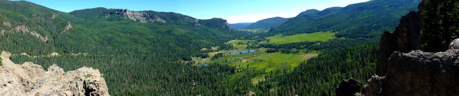
Harry S Truman Reservoir Overlook
It was in the 90s and with full sun and I was quite heated, but I decided to brave the short nearby Western Wallflower Trail. It led across an open prairie top to another overlook, this time viewing westward across another arm of the lake. I could see the Highway 7 bridge I had passed over to reach the peninsula upon which the park is situated. Powerboats roared by, with a large marina visible across the lake. On the return trek I saw a Zebra Swallowtail butterfly.
Homeward Bound
I ended my third day of summer break zigzagging my way homeward across Missouri, feeling I was in the boonies when I saw a turnoff for either highway Z or highway ZZ. I pulled over to shoot the pavilion in downtown El Dorado Springs and later passed a turnoff for highways N or M, which was coincidentally the name of the Agatha Christie mystery I’d listened to on this trip: N or M? I had a tasty dinner at Cheddar’s in Joplin, and afterward was startled by the rays of sunlight bursting through the clouds near the Baxter Springs exit on I-44. I pulled over to see the setting sun pouring through a donut hole cloud. I admired the way the clouds around me were lit and then headed down the interstate with sunset-banded clouds above. This trip was a great start to my summer break!

Donut Hole Sunset
Click here for a slideshow from these day hikes
< Day 2 of Summer Break 2012: Pirates of Powell Gardens


Pingback: Pirates of Powell Gardens « MEADOR.ORG
Most excellent sunset pictures!