June 15, 2012

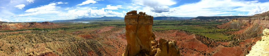
Black Canyon (click image for slideshow)
This post arrives late both because of logistical problems on day 2 of Operation Junebug as well as some health issues on day 3 which I’ll discuss in my third post, which will also be delayed.
Day 2 began in Pueblo, Colorado with a traditional hot breakfast at the Clarion Inn, which also sported incredibly fast WiFi. The only downside to my room was a very loud wall air conditioner that cycled on and off all night. I was itching to get over to the Black Canyon of the Gunnison National Park for the views of that deep chasm, but first I had some repair work to do.
Windshield Repair
A stone hit my windshield just as I arrived in Pueblo the evening before and created a star crack. I knew I had to fix this right away, since dirt in the crack will affect the transparency and permanence of the repair. So I lost almost two hours total buying a repair kit and razor blade at the nearby Wal-Mart and borrowing a couple of spots in their parking lot, one in shade and another in full sun, filling in the star crack as best I could with resin. I’ve done this before on the same windshield with adequate, if imperfect, results. The key is being able to get the glue into the crack.

Windshield Repair
You have to find a shady spot, clean out the crack with a thumbtack, then apply an adhesive ring and nozzle. You squirt in the glue, then use a syringe to apply downward pressure for 10 minutes. Then you reverse and apply a vacuum to it for 20 minutes. Then you remove the nozzle assembly, apply a spot of glue to the remaining pit and smooth a plastic curing sheet over it and let it dry in the sun for 15 minutes. My shady spot on the far side of the building turned out to be an unmarked bus stop as well, so a lady watched me for quite awhile as I worked. She never said a word…don’t bother the mechanic.
I couldn’t get glue into every arm of the star and didn’t get the central pit entirely filled, but it certainly looks better than it did last night and is far less distracting when I’m driving. By the time I was finished it was almost 10:30 a.m., so I headed west on highway 50 toward Cañon City.
Cañon City
TripAdvisor recommended I satisfy my desire for pizza at Pizza Madness downtown. The interior had a big wall mural and I enjoyed some delicious cheese bread and a mushroom and sausage pizza. I picked whole wheat crust as my only sop to healthier eating.

Cañon City
I passed a few old buildings downtown, including the Gothic Revival style Raynolds Bank, built in 1882 from stone quarried at the penitentiary. Colorado’s Territorial Prison opened in Cañon City in 1871 and is now a medium-security facility with the state pen next door with all of its inmates in solitary. My father remembers his parents taking him to see the old prison back in the 1930s. An early form of scared straight? If so, it did wonders since Dad is such a sweetheart. 🙂
Along the Arkansas and Across the Continental Divide
I headed west past Royal Gorge, which I saw with my father two decades ago back when its bridge was still the highest in the world. Cañon City built it in 1929 as a tourist attraction and now charges $26 to cross it and enjoy a variety of rides and other attractions. Having already seen the gorge and bridge, I saved $26, more than paying for the windshield repair, and headed on west.

The Arkansas
This stretch of highway 50 parallels the Arkansas River, with the river straddled by the highway and a railroad track. The winding route is very scenic but you have to really watch the road and your speed.
The road finally reached a broad plain with the Spanish Peaks of the Sangre de Cristo mountain range heaving upward to the south. The bridge at Cotopaxi had a scenic backdrop and soon I was crossing the Continental Divide at Monarch Pass. Then came the steep descent into the high desert country on the western side.
Crossing the divide meant leaving the Arkansas behind. The highway eventually found it could follow Tomichi Creek to the city of Gunnison. The Western State College of Colorado is there, although it is nestled on the east side of town. The city is easy to navigate with nice wide streets, but I did not linger as I wanted to visit the Black Canyon of the Gunnison before this day was out.

Blue Mesa Reservoir
Blue Mesa Reservoir
The Gunnison River joins highway 50 at Gunnison and they track westward together. The Gunnison River is very steep but today its power is thwarted by the Blue Mesa Dam, built in the 1960s for hydroelectric power to form the largest lake in Colorado at 20 miles long and a surface area of over 9,000 acres. Well, that was before the drought.
The prolonged drought in the west has brought the lake down almost 40 feet from its full level and it is currently below 70% of its active capacity. Some islands are now accessible by car. The low level was evident at Wilson’s Landing on the east end of the immense 43,000 acre Curecanti National Recreation Area, which encompasses Blue Mesa along with the Morrow Point and Crystal reservoirs.
The surrounding area has mesas and mountains. I was particularly struck by the Dillon Pinnacles, near the second crossing of highway 50 over Blue Mesa Lake, where erosion has exposed the 30 million year old West Elk Brecchia of solidified volcanic ash and mud. I planned to take a closer look at them another day, having noticed a trailhead at the bridge.
The Black Canyon of the Gunnison
The Gunnison River joins both highway 50 and Tomichi Creek just west of Gunnison and they track westward together. The Gunnison River is very steep and although today its power is thwarted by the Blue Mesa Dam, it used to reach 12,000 cubic feet per second at flood stage on downstream. That gave it the power to cut down as far as 2,722 feet through hard Precambrian gneiss and schist, forming a very deep and narrow canyon in a large uplift area. Sunlight struggles to peer down into this crevice, hence its name.
The multiple stupendous vistas at the Black Canyon led me to shoot one panorama after another, along with several videos, further slowing my editing for this post on my tiny MacBook Air. What a help this little computer has been, even with its limited processing power.
I pulled into the park and paid $15 for my vehicle. It’s a seven-day pass, so I could return later in the week if I wish to. I followed the South Rim road; the north rim road is gravel and the ticket lady said it was a 90 mile trip by car from the park entrance. Since it was already 4:00 p.m., I’d better stick to the south, eh?

South Rim
Tomichi Point
Right off the bat was a stunning view at Tomichi Point. I keep seeing Tomichi Creek and now there’s a Tomichi point? Who was or were the Tomichi? Well, it’s a Ute indian word and various sources claim it means “hot water” or “mountain stream” or “dome-shaped rock” and even “good wintering ground.” The last one seems unlikely, given the severe winters around here! For such a common word hereabouts, it is interesting that there is no clear translation.

Tomichi Point
Anyhow, the view was to the southeast. A couple of miles downstream is a 6-mile long tunnel dug in the early 1900s to provide irrigation water from the high Gunnison, running in its deep mesa canyon, to the low farmlands to the southwest near the town of Montrose. It was the longest irrigation tunnel in the world when it was constructed and is still in use.

Pulpit Rock
Pulpit Rock
The next stop was Pulpit Rock, since I chose to skip the Visitor Center at Gunnison Point. I found a cycle couple out on the immense stone pulpit, enjoying the view and reading the signs. I asked if they wanted a photo and they were delighted to be snapped together out on the rock and did the same favor for me, so I can now see myself preaching to the stones.
The view from on top of the pulpit was inspiring. I shot a panorama, of course. You can see how the north rim, to the left in the panorama, has far steeper walls than the south rim.
Cross Fissures
Most people were skipping the next stop, but I walked over to where the canyon rim projected outward in a fin with a viewpoint on either side. Projecting vertical fins of rock plummeted downward vertiginously toward the hidden river below, providing another spectacular panorama. One view was of a strip of rock descending along the cliff face along another creek fissure. And across my own projecting fin was another viewpoint of how the next fin projecting out into the canyon was broken, creating an island peak.

Cross Fissures

The Narrows
The Chasm: The Narrows of the Gunnison
I skipped the next two viewpoints for one of the most dramatic, with a great view of The Narrows, the shallowest section of the canyon and only a quarter-mile across from rim to rim. Notice the immense rockfall coming down from a side fissure. I shot a video zooming in to the tumbling water and multiple waterfalls on the river below and then following the river tumbling its way through The Narrows before zooming back to the full view from the Chasm View. Needless to say, shallowest is a relative term!
The Painted Wall

Painted Wall
I skipped two more viewpoints to reach the Painted Wall. This is the highest cliff in Colorado, jutting 2300 feet above the river. The Empire State Building would reach slightly more than halfway up this enormous edifice. It has bands of color shooting through the rock, created by molten rock squeezing into fractures and joints in the existing rock and then cooling in place. The bands are more visible in a video I shot than in the still.

Sunset View
Sunset View
The penultimate viewpoint is from a projecting fin looking northwest along the river. The web shows that it looks fantastic when the sun is streaming in, but we were still a few hours from sunset and the sky directly overhead was overcast. But I liked the view anyway, with the narrow band of water rippling off into the distance. At full zoom I could capture the rays of the afternoon sun reflecting off the most distant canyon walls. A video helps provide a sense of scale.

Warner Trail
Warner Trail
The park saves the best for the last. The final stop on the south rim road requires that you park and walk northwest 0.8 miles along a ridge for tremendous views of both the farmlands below as well as the Black Canyon at its deepest point. I’d walked hundreds of yards back and forth from viewpoints to the road, but this was finally a real, if short, hike.
Mark T. Warner was the pastor at Montrose Presbyterian and led the effort starting in the late 1920s to have Black Canyon made part of the national park system. Warner was born and raised in Ohio and came to western Colorado in 1917, so perhaps his background made him especially aware of the canyon’s unique character. President Hoover named it as a National Monument in 1933 and 66 years late President Clinton would expand its boundaries and redesignate it as a National Park.
The view southwest had layers of forest, fields, desert, and distant snow-capped mountains, which were a backdrop for a self-portrait. I was struck by the contrast between the pastoral scene below the edge of the ridge compared to the non-irrigated desert areas. No wonder the farmers around Montrose were desperate enough to have that 6-mile tunnel drilled. But even the desert area was being harvested, but not for crops.
On the other side of the ridge was a cutout view of the north rim of the Black Canyon, with its terrifyingly steep walls. A large tree had broken and died beside the trail, its upper branches pointing toward the end of the trail.

Warner Point
Warner Point
That end came as a bluff crisscrossed by trails made by eager viewers. The view upstream was evident and rewarding, and I posed again, also shooting a video of the panorama. The view downstream presented the canyon true to form: looking pretty black. The view southwest from Warner Point had the jutting walls and pillowed desert leading to flat fields in the distance near Montrose.
I took a shot of a British couple for them when they arrived at the point and then vacated so they could enjoy the vista undisturbed. The trail led back up along the forested ridge, buttressed against erosion in some of its steeper sections. There were a few clumps of flowers along the way, and I paused to shoot a dead tree here on the south rim against the backdrop of the steep north rim.
Back to Gunnison
The trail led downward to my waiting car, ready to race eastward back to Gunnison for dinner. The huge W on the mountainside, for Western State College, signalled arrival. I had an excellent steak at the Ol’ Miner Steakhouse downtown. I’ve passed up its partner at Pagosa Springs on two previous trips, but if the one there offers food like this, that will change.
Up to Crested Butte

Sunset
The sun was setting as I headed north from Gunnison, steadily ascending from its 7,700 foot elevation to over 9,500 feet at Mount Crested Butte. The imposing silhouette of the mountain in the twilight was a bit foreboding, and in fact there was trouble to come.

The Grand Lodge
But I arrived safely at the Grand Lodge and checked in with a very pleasant and helpful night clerk. My room was oddly shaped, with a bay window merging into a window wall with angled panes, but it had a castle tower-like ambience. They already had the television on, playing some soft symphonic music from a music channel and the room was already lit. A table with a lamp was situated in the bay window, and if you look at the far left of the second floor in the exterior photo, you’ll see that lamp silhouetted against the room light. No air conditioning was needed; they’d already cracked one window just a hair and had the ceiling fan softly purring since it was already in the 40s outside. Pretty classy!
Foreshadowing
I settled in and began creating this post and editing photos, but I was exhausted and stopped before I had reached the Black Canyon. My nose had begun dripping, I was coughing up some phlegm, and felt a bit woozy. No, it wasn’t a virus or a bacteria, but I was indeed coming down with something…altitude sickness, despite my precaution of drinking lots of fluids throughout my trip. More on that in the next post – whenever I get it done!
Click here for a slideshow from this day of my trip


Pingback: Junebug Day 1: The Rim of the Volcano « MEADOR.ORG