
TRIP DATE: June 15, 2017 | SLIDESHOW | PHOTO ALBUM
On Day 7 of our Grand Adventure we traveled to Santa Fe with long stops to hike at El Morro and to explore the Bandera volcano and its ice cave.
After the commencement ceremony for the Class of 2017, I was approached by Barbara Davidson, who taught at Bartlesville High for many years and now is a valued substitute teacher. Knowing we were headed to the Grand Canyon, she recommended we visit the Land of Fire & Ice, a volcano and ice cave in New Mexico. So in our hotel room in Gallup I checked the route to the attraction and noticed that if we drove south on Highway 602 out of Gallup into the Zuni Reservation, we could divert east on 53 to visit the El Morro National Monument before we got to the volcano. I’d never heard of El Morro, but noted it had a hiking trail, something which appealed to me greatly. So after breakfast at the hotel I led our two-car caravan there.

El Morro
El Morro is Spanish for “the headland” and denotes a cuesta (a long rock formation that slopes gently upward and then drops off abruptly) situated along a main east-west trail in what is now west central New Mexico. It is known for having over 2,000 inscriptions along its base made over the centuries by Native Americans, Spanish colonials, and Americans. I wonder how long it takes for graffiti to transform from vandalism into historical artifacts?

The Zuni indians have lived in the area for 3,000-4,000 years. Back in 1275 they established the Atsinna pueblo atop El Morro. Atsinna means “place of writings on the rock”, so there were already petroglyphs along the steep outer walls of the cuesta by then. For about 75 years between 1,000 and 1,500 people lived atop the cuesta before the settlement was abandoned.
The Most Famous Inscription
The first European to carve his name on the rock was Don Juan de Oñate in 1605, writing, “There passed this way the Adelantado (conqueror) Don Juan de Oñate from the discovering of the South Sea on the 16th of April 1605.” He had led several expeditions across the southwest, confirming that the region we now know as New Mexico lacked precious metals but could sustain colonists willing to work the land. No doubt he stopped at El Morro because of the pool of water which collects at its base.
You may wonder about the color of the inscription. In the 1920s the first superintendent of the monument went over some of the inscriptions with a hard pencil in an attempt to preserve them, since the soft sandstone deteriorates over time. These days the conservation efforts are less intrusive.
Oñate’s stop at El Morro was six years after he had ordered the Acoma pueblo destroyed in retaliation for the deaths of a party of 12 Spanish soldiers. Hundreds of natives, including women and children, perished in the massacre, and it wasn’t long after visiting El Morro that he was finally held accountable. In 1606 he was recalled to Mexico City as he was laying out the plan for Santa Fe. Oñate was tried and convicted for his cruelty towards the natives and was banished from New Mexico and Mexico City. He eventually returned to Spain to live out the remainder of his life, dying there in 1626 at age 76.
The Inscription Trail
We arrived at the monument around 11:30. After using the facilities and exploring the gift shop, we registered at the desk for the hike, receiving a laminated book on the carvings to be found all around the headland.
Our demanding work schedules led to Wendy and I only going on a few hikes since November 2016. I blame that for my forgetting to activate my iPhone’s MotionX GPS tracking app for the hike. Later I reconstructed the hike by hand in Google Earth.

Some ladies ahead of us on the paved trail made much of the possibility of sunning snakes, but we never saw any. The vertical cliffs above us had interesting darker patches hanging onto the cliff face.

We soon reached the pool at the base of the headland, filled with water from runoff and snowmelt. Originally there was a basin hollowed out by water cascading from above. The first caretaker of the monument deepened and dammed the pool in the 1920s. A rockfall destroyed that dam in 1942, and a new one was constructed.
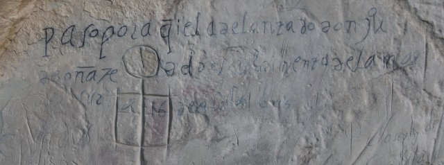
Some of the inscriptions overlapped each other, with a mix of petroglyphs and modern writing. A particularly beautiful one was by E. Pen Long, a member of the U.S. Army from Baltimore who was a member of the Beale caravan of 1857-1859. Reportedly he had the use of tools for carving gravestones, allowing him to sculpt fine details in the soft sandstone. Lt. Edward F. Beale′s group was experimenting with using camels as Army animals in the southwest. Beale’s group included 25 packs camels, part of the Camel Corps, and he was quite impressed by their endurance and packing abilities. The Civil War interfered with the project, and it was abandoned. Unfortunately that didn’t prevent me from seeing the regrettable comedy film based on this project, Hawmps!, back in 1976. I’d already suffered through The Apple Dumpling Gang a year earlier, and am thankful that I remember little of either film over 40 years later. If I have to watch a comedy western, please make it Blazing Saddles.

Speaking of humor, some of the inscriptions are funny. One translates as, “The 14th day of July 1736 the General Juan Paez Hurtado, Inspector, passed by here.” Right below this was added, “And in his company, Corporal Joseph Trujillo.” I’ll wager the General had his back turned. You can see many more images and descriptions of the inscriptions in a blog post by Wayne Chatfield.


As we rounded the tip of the cuesta, there were many inscriptions both high and low, including some that were boxed. Ones ending in U.P.R. were carved by a Union Pacific Railroad survey crew that came by in 1868. That project wasn’t carried through, since the Santa Fe Railroad went through 25 miles north of El Morro, ending its place as a stopover on the route west. Otherwise, El Morro might today be adjacent to I-40 and would no doubt have even more graffiti.
Wendy took a neat vertical panorama shot of the tip of the monument with her iPhone, with the sun glaring down. That illustrated how it was getting pretty warm, and both John and Wendy decided they would prefer not to continue the hike up to the top of the cuesta to view the pueblo ruins. So they took a side trail back to the visitor center while Betty and I forged onward.
The Mesa Top Trail
We passed a nearly vertical smooth face of the monument, unmarred by old graffiti. Up near the top edge of the cuesta we could see a huge slab of rock that would someday separate and fall.

Cavelike openings in the side of the wall are formed when rain atop the mesa enters cracks in the rock, runs down the joints, and comes out of small openings on the side. The seeping water and freeze/thaw cycles weaken the sandstone and forms large holes. The sandstone in this area is only sand grains held together by kaolinite clay, since it was never buried deep enough for pressure to fuse the grains into more solid rock.

We rounded the point where the huge slab of rock will someday collapse and the trail began climbing to the top of the mesa in a series of switchbacks. Up top we had a panoramic view of the broad flatland separating El Morro from another mesa, with the highway running between them.

The flatland was formed when water gradually wore away the softer rocks of the Chinle formation, with the harder sandstones of El Morro and the other mesa resisting the erosion. More than ten thousand feet of sedimentary rocks have been removed over the last few million years to form this landscape, which was under the water of an ancient ocean about 100 million years ago. 40 million years before that, the sand that makes up El Morro was accumulating on a broad desert-like plain.
This geologic history explains the color variation in the layers of El Morro. The dark upper layers are ocean sands, while the light colors below that are from earlier stream and dune sands of the desert period. The valley floor also has a veneer of volcanic basalt that was laid down 100,000 years ago. To the east is the Chain of Craters area of El Malpais National Monument, including the volcano we’d soon be visiting. The most recent eruptions there date back 3,000 years.

Up top we could see how El Morro is a hollowed out headland, with a box canyon eroded behind that. The trail ran along the top of the remaining headland around the box canyon to eventually reach the excavated pueblo ruins atop the far side of the cuesta, although there were unexcavated ruins on the near side as well.

A huge pillar of uneroded stone remained near the center of the box canyon. We walked along the rim, following a marked line across the stone. Tilted shrubby trees grew up top, and we crossed the long joints in the top which erode to create the cuesta’s sharp vertical headland. To our left was a panoramic view of the countryside.
Pueblo indians enlarged potholes on the top of the mesa to capture rainwater, in addition to relying on the pool at the base of the cuesta. Parts of the trail ran along the joints in the rock. I had Betty pose in one joint and at a saddle connecting the two halves of the headland.


We passed by the end of the box canyon, with its flat floor displayed below. The top of the formation had a white layer that had eroded in one spot into a hoodoo. The park service has carved steps and stairways into this layer in various locations, making the trail more accessible and fun. The white layer was its own trail marker, leading us over to the Atsinna ruin. Betty gamefully tagged along behind me as I eagerly scrambled over the rock face.

As we approached the excavated ruins, we could see the line of white stone behind us. This white layer is bleached Zuni Sandstone, formed when active erosion and weathering over 50 million years attacked green clay minerals and feldspar, altering them to white kaolinite clay. Iron dissolved and percolated to form dark crusts and bands lower down. The removal of the iron and alteration of the green clay produced the white bleached zone. Kaolinite is used in many products, including paper, toothpaste, light bulbs, cosmetics, and the old formulation of Kaopectate I grew up with. I will never forget its chalky taste.
We finally reached the ruin of the Atsinna pueblo. The entire pueblo, mostly unexcavated, is about 200 by 300 hundred feet long and parts of it probably were three stories high along the north side. The pueblo was terraced down to the south, providing a southern exposure. In 1954 twelve of the rooms and both a round and a square kiva were excavated by Richard B. Woodbury and a Zuni work crew. The entire pueblo probably had more than 800 rooms.

Today’s hikers are actually walking on the second level of the pueblo, about ten feet above the original ground level. The ground level was filled with debris from the collapse of the upper stories after the settlement was abandoned.
It is speculated that crop failures may have led to that decision, since the people seem to have moved west and founded Zuni villages known in historic times. There, around the present Zuni pueblo, the growing season is longer and irrigation can be practiced.
The pueblo had a commanding view of the lands to the east. We could see the Visitor Center below, where Wendy and John were patiently awaiting our return.


We followed the trail down the side of the cuesta. Pareidolia, our mental habit of seeing faces in nature, had me seeing the profile of a heavily beaded conquistador at the right edge of a formation atop the hillside above us.
Wendy and John were relaxing on the porch at the Visitor Center, having visited with the ranger and conversed with each other while Betty and I sweated our way across the top of the cuesta. I had water while hiking on the trail and at the visitor center, but I was yearning for a cool soft drink, which the monument did not offer. So I was glad the Ice Cave and Bandera Volcano tourist attraction was only a 25-minute drive to the east, as I knew they offered snacks at their trading post. We left El Morro at 2:30 pm.
Ice Cave & Bandera Volcano
Back in the 1930s a trading post was built here with a saloon and dance hall. They mined ice from the ice cave to cool the beer! In 1946, Dave and Reddy Candelaria began operations as a tourist attraction, halting mining of the ice.
While the others in our party explored the artifacts, rocks, pottery, and so forth in the trading post, I found the soft drinks at the rear and enjoyed a cool and freshing can of Coca-Cola. We paid to hike the trails and opted to do the crater trail first. That way we could recuperate from a warm hike up into the crater of the volcano by visiting the cold ice cave.

The crater was northwest of the trading post. The trail went past a spatter cone. When a surge of hot air rushing through lava forms surface tubes and minor vents, it splashes out when the air breaks through to the surface, forming this sort of blow hole.

Soon we were slowly circling and climbing the side of the cinder cone. John commented on how the benches all along the trail were always placed in full sun, making them less than desirable on a hot sunny day like we were having.
Eventually we rounded to where we could see where the side of the crater had blown out. The trail led on past jagged lava formations, and the ladies briefly sheltered in a trailside lava overhang.

Beside the trail we could see colors from various elements leaching from the lava. White areas were calcium, yellow were sodium and sulfur, and red was iron.
The El Malpais region has 29 volcanoes, and Bandera is the largest. Its cinder cone developed 10,000 years ago. Then a massive lava flow broke out on one side and extended 23 miles across the landscape. The extinct crater is about 1,400 feet wide at the top and about 800 feet deep.


We made our way back to the trading post to enjoy its restroom and some cool drinks. Before setting out to see the ice cave, Betty bought a couple bags of dirt spiked with gemstones, arrowheads, and more. She and John have expertise in panning for gold, and Betty showed Wendy how to pan for the gems using a the large sluice set up beside the trading post. John and I sat in the shade nearby and chuckled as Wendy delightedly panned for her rocks.
Then we took the shorter trail south to the ice cave. A long wooden stairway led down into the cave, which was in part of the Bandera lava tube. When molten lava pours out of a volcano, the porous lava is a great insulator, so the surface hardens while a pipeline of lava flows beneath. The Bandera tube is 17.5 miles long, and most of it has collapsed. I had a memorable adventure back in 2009 hiking over a mile through an intact lava tube at the Newberry monument in Oregon.

The cave temperature never rises above 31 degrees Fahrenheit because it contains a 20 foot thick well of ice that has accumulated in a well insulated cave shaped so that the frigid air is trapped. The Pueblo indians knew this as Winter Lake and mined the ice. The thick ice is green with algae and its deepest layer dates back 3,400 years. Mining of ice before 1946 left an ice wall against the back of the cave that reached 12 feet high, but since then the floor has risen as ice accumulated, the rate varying with annual rainfall.
After hours up in the sun, we all loved the cold air down above the ice. We could feel a dramatic shift in temperature as we descended below the overhanging cave mouth. It was startling to see icicles hanging from the lava given the hot day above us. I got a shot of little domes of ice formed by water drips.
Onward to Santa Fe
It had been quite a day, but we had missed lunch and were hungry. So at 5 p.m. we set course to find dinner on I-40. I wanted something filling, so we ended up at the Pizza Hut in Grants. The train track was nearby, and when one of the many trains we had seen throughout the trip rumbled toward us, Wendy whimsically gestured for the engineer to blow the horn. She was overjoyed when he obliged.
Our party arrived at the Hotel Santa Fe at 9 p.m. Wendy had fun arranging the petrified wood she had purchased, along with the gemstones and arrowheads she had panned, in one corner of a countertop in our room. Kion guarded her treasures.

The next day would be the last day of our vacation shared with the Hendersons, as they would be heading home in the afternoon while Wendy and I stayed on for a few days in Santa Fe.


