
At Lake of the Ozarks (click image for slideshow)
I’ll wrap up 2011 with a lengthy post about four trails I hiked at Lake of the Ozarks on the last day of the year.
Coping with Hotel Living
Earplugs are my strategy for some hotels. The new one I stayed at in Osage Beach was, as reported in online reviews, run by a friendly couple but suffered from poor architecture. It had a large central corridor which functioned as a resonance box for the indoor pool at one end and all of the inevitable slamming doors from typical thoughtless guests. But my earplugs kept me undisturbed, the bed was comfortable, and the continental breakfast was varied and fresh. It’s a shame earplugs can’t compensate for a cramped bathroom, but it was a budget hotel after all.
Lake of the Ozarks Area
On the last day of 2011 I’d hike on four different trails in the Lake of the Ozarks State Park, straddling it with hikes at the west and east end. These added to the previous day’s hike there and a hike in September 2010 at nearby Ha Ha Tonka. I haven’t exhausted the trails in this area, so I’ll be back in 2012. The long drive from Bartlesville means I will need to stay at an area hotel, so I might try returning here over Spring Break. I wouldn’t like the big summer crowds.
Grand Glaize Trails
By 8:45 a.m. I was on the first trail, which was only a few miles away in the Grand Glaize area on the west edge of the state park. The area name refers to a flooded creek but the origin of the name is uncertain. It lies only a few blocks east of the south part of Osage Beach (aka Laguna Beach), and the area is known for its summer partiers. The state has redesigned the park entry road, which fooled Trixie the GPS, but I had little trouble finding the trailhead for the Rocky Top Trail, a 2.5 mile double-loop.
This wasn’t Tennessee, but I’ll confess I did have the old bluegrass song in mind as I began my hike. Oh my, but I still love it when Buck Owens kicks it into gear. Hee Haw rubbed off on me a bit, I guess. Gloom, despair, and agony on me.
And since it was New Year’s Eve, I could ask, “Where, oh where, are you tonight?” Yes, they did it on Porter Wagoner too.
Okay, I apologize for that. Let’s get back to the trail…
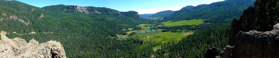
It was still in the 40s so I opted to walk the trail so that I’d be in the sunlight along the lake shore for the start of my hike. I walked past a shelter and down to the shore, where a bright sun was climbing the sky. A fisherman was standing in his boat close to shore and we waved as the trail hugged the shoreline. I reached the waterway which separates the two trail loops and crossed it so I could ascend the adjacent hill to an overlook. The trail, like both of yesterday’s, followed a ridgeline to a point. But this time it was a broad high cliff providing a sweeping eastward view of this arm of the lake.
I spotted a fisherman below the bluff and zoomed in for a look, deciding it might just be a fisherwoman…hard to tell. Across the way were various condos, and boats and birds passed by the point. I could see that I was standing on an overhang of a high eroded bluff and managed to bushwhack down the edge of the bluff and made my way over along its lower and colorful face to stand beneath the overlook. Some large pieces of rocks had broken away, and a bit of greenery was bursting from the bluff. I was very glad I’d made this bushwhack and climbed back past the eroded rock face to the trail, where the Ozark savanna led down into the lake.
I found more tree fungi of various sorts. I returned to the first loop and followed it up to reach a profusion of pockmarked rocks as I exited the forest into a large sloping glade which justified the trail’s name. This truly was a rocky top, with many eroded stones protruding from the grass. I shot a panorama and then exited the glade, which was close to the trailhead. Altogether a most satisfying start to my day.
I knew the nearby Shade Ridge Trail would be less interesting, as it simply hugs the lake shore connecting the marina to the Pa He Tsi area. But it was so close I couldn’t pass it up, so I drove over to the trailhead, discarded my heavier jacket and ear pops since the temperature had climbed into the 60s, and crossed a short bridge onto the trail. It hugged the lake shore part of the way, providing ready access to the water where I could see a fishing boat silhouetted by the glare of the morning sun. Along the trail there were pleasant views of the lake developments. I peered down into a fallen log’s maw, but thankfully nothing came popping out at me.
Squirrels scampered about, as they had on parts of the earlier trail, but they were skittish and would not pose for the camera. I forded a small steady stream and arrived at the closed entrance to the Pa He Tsi area. The name refers to the Big Osage tribe or “campers on the mountain” in contrast to the Little Osage or U-ʇseɥ-ta or ‘”campers in the lowlands”.
I retraced my steps, passing a dead tree which poked at the clear blue sky. The low sun was lengthening my short legs enormously as I walked over to the stream, where some tree roots formed a miniature waterfall. A plane flew overhead toward the nearby landing strip. A couple of fishermen were plying the edges of a cove as I returned to my car. It was time for lunch.
The Lake of the Ozarks and Bagnell Dam
I was craving pizza and Yelp said there was truly excellent pizza to be found at the Alley Cats bar to the north in Lake Ozark. I don’t care for smoky bars, but the lure of crispy tasty pizza was irresistible. So I made my way over, finding I had to cross Bagnell Dam. The half-mile long dam was constructed by Union Electric of St. Louis from 1929-1931 and rises 148 feet from bedrock (so it’s about twelve stories high and seven blocks long). It was named for the town site where it was built, which of course is gone today. At full capacity 30,000 gallons of water can flow each minute through each of the dam’s eight turbine generators, producing 215 megawatts of electrical power.
The dam impounds 600 billion gallons of water and forms over 1,150 miles of shoreline along what the company called the Osage Reservoir, the Missouri legislature named Lake Benton, and everyone still insisted on calling Lake of the Ozarks: the largest man-made non-flood control lake in the country. Since the lake level is very steady, unlike many flood control lakes built by the Army Corps of Engineers, the shorelines have been intensively developed by private interests. Recently the Federal Energy Regulatory Commission ruled that many structures are actually on utility-owned land and ordered thousands of home and businesses to be moved, causing widespread concern and consequent clarifications.
The main road into Lake Ozark, a tourist strip replete with restaurants, bars, and shops, runs over the narrow top of the dam which clearly was meant for smaller cars. You are supposed to creep along at 25 miles per hour, which I dutifully did to the dismay of several young fools behind me, who recklessly zipped around my car both before and after we crossed the dam. I certainly wouldn’t want to be around here in the summer swarm. I’ll take a lonely forest or mountain trail over swarming crowds of tourists any day.
The bar was small and a bit smoky, but the pizza was superb. The bartender proudly pointed out the huge trophy they had won in a pizza cook-off and I had to agree that it was some of the best pizza I’d ever had. Bikers pulled in and drank as I happily consumed my hot, thin, and crispy mushroom confection.
I recrossed the narrow dam and drove up to an overlook. The electric utility had put up a nice set of displays and a viewing platform, along with one of the massive old turbines. The 1931 turbine is cast steel, weighs 50 tons, and rated to produce 33,500 horsepower at 90 feet of water pressure at 112.5 rev/min. I know, only a physics teacher could love such statistics!
The overlook provided a nice line of sight along the dam and one could see the extensive shoreline development. The drive down the other side of the overlook provided a nice view of the dam.
Horse Trails
It was time for the afternoon hike, which I planned for some hiker/equestrian trails at the stables on the east side of the huge state park. I reached the empty Hidden Springs Trailhead at 1 p.m. and set off down the wide trail. Thankfully there was little prominent manure and I enjoyed the wriggling descent down toward the lake. Now it was the afternoon sun forming my silhouette as I strode through tall trees past an almost illegible sign which read “Half Way There”.
Finally the lake appeared and the trail ran northeast parallel to it. It rose to an overlook, but the view was obscured by trees and I bushwhacked downslope for a splendid view.
In front of some low islands a number of birds were lined up along a floating log in the lake. The wind was whipping and I hung onto an odd tree arch on the promontory before climbing back up to the zigzagging trail. I reached an intersection with the south loop of the immense Trail of the Four Winds. The south loop is 9.25 miles long while the north one is 4.25 miles and the 13.5 mile trail is clearly popular with equestrians since there had been a number of horse trailers at its trailhead.
This part of the long trail led down toward the water. Eager to get a better look at the birds, I followed it down. Ferns were growing alongside the trail and I reached the shore where I could see birds fishing in the water, riding the stiff wind and diving to the water after prey.
I followed the Trail of the Four Winds for a couple of miles, passing high bluffs and then making a winding ascent between waterways, but the views were limited and I finally decided to turn back. Rather than wind my way back around the waterway I bushwhacked down it and across, finding more tree fungi in the form of wide white fans. An opossum beside the trail eyed me warily as I passed, but wasn’t scared enough to play possum. I trudged back up onto the Hidden Springs Trail and eventually the Trail of the Four Winds split off and I returned to my car for the long drive home.
Day Hike Statistics
It had been a satisfying end to 2011, with me tacking another 9.5 miles onto my day hike total, bringing it up to 326.3 miles for the year. Since I hiked 50 days in 2011 that averages to 6.5 miles per day. I continue to rack up many auto miles finding new trails, having exhausted so many trails since July 2009. Since then I have hiked 56 days in Oklahoma, 23 in Arkansas, 11 each in Kansas and Missouri, 9 in Oregon, 8 in Colorado and 3 in New Mexico. But there are still some unexplored trails in Oklahoma and many more in Missouri and Arkansas beckoning my boots. Summer vacation continues to be a great time to pick up more trails in Colorado or the Pacific Northwest and escape July in Joklahoma.
I’m still eager to get out and walk about, shooting pics and listening to audiobooks. I agree with Nate Desmond of Practical Manliness about the benefits of day hiking, but for me #5. Relieve Stress ranks above #3. Foster Relationships since I use solo day hikes as a chance to escape from people and work, indulging in my own favorite pastime. But I’m not a complete loner: I do share my photos and write extensively about each trek. I know some folks who just look at the photos, some who read every detail, and several of my friends never look at my posts, period. And that’s just the way it should be. As Cicero wrote, “Suum cuique pulchrum est.” To each his own is beautiful.