

I grew up in Oklahoma City, and when I was little my parents purchased a cabin on Table Rock Lake in the Ozarks of far southwestern Missouri.
That second home was the destination for most of our vacations from 1968 to 1984. Getting there took a long time from the perspective of a child, so I also have vivid memories of the long drive along this route:

That trip originally took about four-and-a-half hours of driving time, which lengthened by an hour when I was in second grade. The Arab oil embargo hit, and to conserve fuel highway speed limits were lowered to 55 miles per hour. That cap held until 1987, by which time I was halfway through my undergraduate studies in college.
The trip would have been even longer had we chosen a more famous road over Interstate 44.
Route 66
The most famous highway in Oklahoma is U.S. Route 66, which was established in 1926. Cyrus Avery of Tulsa championed the development of the route from Chicago to Los Angeles, and it would enter popular culture.
John Steinbeck called it the “Mother Road” in his 1939 novel The Grapes of Wrath. The highway spawned a hit song in 1946, a 1960s television series, and more. I was certainly aware of it, as I lived only blocks away while in grades 1-12.
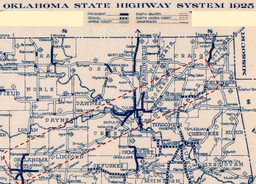
A century ago, the rapid growth of automobiles created a demand for better roads. Oklahoma had 15,000 cars and trucks in 1914 and over half a million by 1926. The dilemma is clear when you look at the 1925 state highway map.
In the excerpt below I’ve outlined original Oklahoma Route 7 from Edmond, north of Oklahoma City, running northeast to Tulsa and Vinita. The route connecting Oklahoma’s two major cities was still graded dirt from Arcadia to Sapulpa, and again just graded dirt northeast of Tulsa from Claremore to Vinita and Afton before it became a paved road heading north to the mining district around Miami.

Cyrus Avery was a businessman with experience in insurance, real estate, oil and gas, and farming. He successfully pushed to bring water from Spavinaw Creek, where he had lived briefly as a teenager, to Tulsa, which ensured its future. He was also an advocate for better roads and responsible for the construction of the Eleventh Street Bridge over the Arkansas River in Tulsa, which was completed in 1915. Avery was appointed to the state highway commission in 1923 and implemented a gas tax. In 1925, he was appointed to the federal Joint Board of Interstate Highways.
Congress had requested a route from Virginia Beach, Virginia to Los Angeles, California. Avery successfully argued that to avoid the high peaks of the Rocky Mountains the road should not cross Kansas but turn south through Tulsa and Oklahoma City and then head west through the Texas Panhandle. He also persuaded the board that a highway was needed along the flow of commerce northeast from Springfield, Missouri through St. Louis to Chicago.
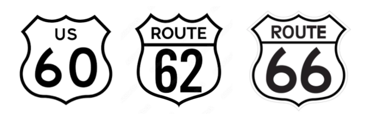
Avery wanted the Chicago-to-LA route numbered 60 in the new numbering scheme, but Kentucky would have been left without a major numbered highway in the overall scheme, and pushed to have 60 designated from Virginia Beach to Springfield and Avery’s route numbered 62. He disliked that number, and instead chose 66, which was ratified by Congress in 1926.
In 1927, Avery pushed for the creation of the U.S. Highway 66 Association to promote paving the route end-to-end and tourism along it. It took a decade to realize that ambition, with it paved from Oklahoma City to Vinita by 1933, the entire way through Oklahoma by 1937, and end-to-end by 1938.
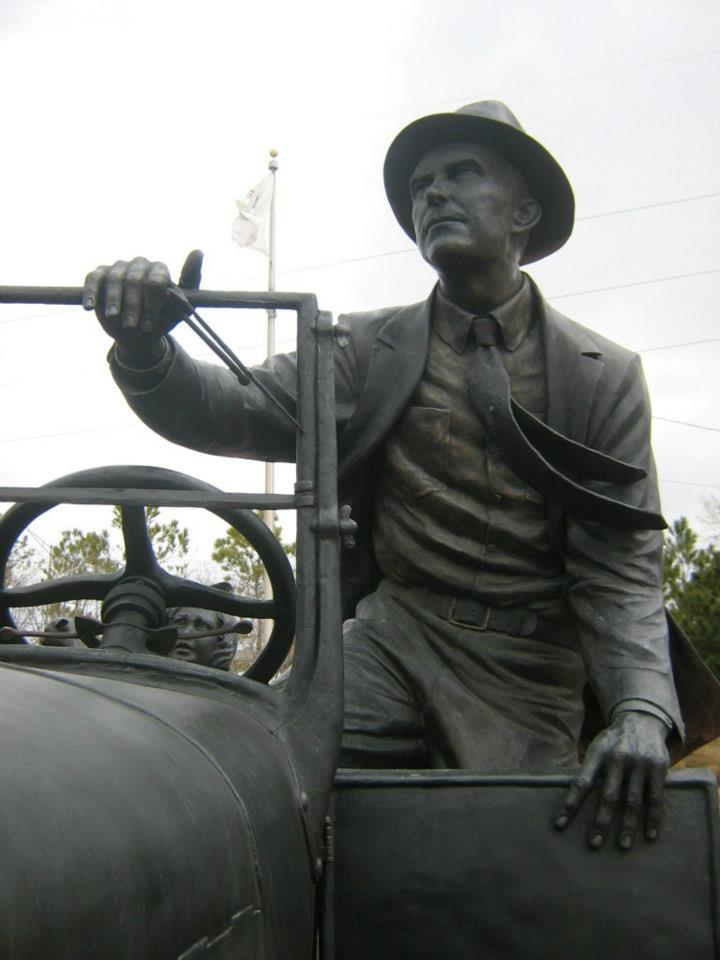
Sadly, Cyrus Avery lost much of his money in the Great Depression. He was unsuccessful in a 1940s race for Tulsa County Commissioner, and a son died suddenly in his 30s. At nearly 80, Cy Avery took a sales job with Lock-Joint, the company that had made the pipe connecting Spavinaw to Tulsa. But through it all, he remained upbeat. On his 85th birthday, Avery remarked, “I’m just a little guy, but I like Oklahoma and this region. I appreciate all the kindness that has been shown me.” He passed away at age 91, while living with his daughter in California…at the end of Route 66.
One of the most popular road songs ever written, Get Your Kicks on Route 66, was penned by jazz musician Bobby Troup in 1946 while driving west to seek his fortune in LA. He credited his former wife, Cynthia, for the half dozen words of the title and refrain. I grew up watching Bobby portray Dr. Joe Early in the television show Emergency! which also starred his second wife, singer Julie London, as nurse Dixie McCall. Here is Bobby singing and performing his song at his second wife’s show in Japan in 1964:
It was Nat King Cole who made the song a hit back in 1946, but I would have loved it had Johnny Gage and Roy DeSoto called Rampart Hospital between calls to have Dr. Early and Nurse McCall sing about getting their kicks on Route 66.
In 1990, author Michael Wallis wrote Route 66: The Mother Road, and his distinctive presence and voice are now inextricably linked in my mind with the old road. Watch the next clip to see what I mean:
You can watch the entire 1994 video here.
Route 66 has various alignments over the years. Here is an online map of its pathways in the Sooner State.
Old 66 was replete with tourist traps, motor courts, and Americana. But the narrow two-lane highway couldn’t keep up with America’s growing car culture. The construction of the new Interstate Highway System began in the mid 1950s and by 1970 Route 66 had been bypassed by interstates 55, 44, 40, 15, and 10. It was decommissioned in 1985.
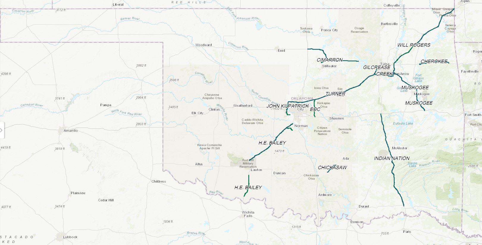
Oklahoma has more drivable miles of Route 66 than any other state, and our family could have taken old Route 66 from Oklahoma City all the way to Vinita before veering off to the Ozarks. But we avoided the road, which was old, slow, and free. Instead we paid to drive on the state’s first turnpikes along Interstate 44.

The Turner Turnpike

The Oklahoma Legislature authorized a turnpike from Oklahoma City to Tulsa in 1947, almost a decade before President Eisenhower and Congress launched the interstate highway system.
Roy J. Turner was the Governor of Oklahoma from 1947 to 1951. A group of Oklahoma City and Tulsa businessmen convinced him of the need for a four-lane divided highway between the state’s two major cities. Traffic studies back then determined that the average speed along Route 66 between the two was only 36 miles per hour.
An interesting thing about Governor Turner is that he wrote songs as a hobby. While he was in office, My Memory Trail was a 1949 single with Henry Jerome and His Orchestra and sung by Hal Barton. And during his term he also composed and published Oklahoma – When the Red Bud Blossoms Bloom.
Turner had established the 9,600 acre Hereford Heaven ranch five miles east of Sulphur in 1933, so I’m not surprised that he had earlier composed the song Hereford Heaven, which was sung by the Flying L Ranch Boys from nearby Davis: Slats, Shorty, Bill, Smiley, and Stumpy. I kid you not.
Roy Rogers’ 1946 film, Home in Oklahoma, was filmed on the Bill Likins’ Flying L Ranch, and the ranch boys were featured. The song begins at the 53:20 mark in that old singing cowboy movie, which I used to have linked below, but good old copyright claims nixed that.
By the way, it was on the Flying L Ranch that Roy Rogers and Dale Evans were married on December 31, 1947. And the boys were there, singing Governor Turner’s songs before the nuptials, switching from “Hereford Heaven” and “Oklahoma Paradise” to “I Love You Truly” for when Roy walked in and “Here Comes the Bride” for Dale. Only in Oklahoma, folks, but it worked well, as Roy and Dale were married for the next half-century until Roy’s passing in 1998.
By the way, Turner’s famous 1936 international champion bull, Hazford Rupert 81st, could easily have been the model for the later portable statues they used to plant in front of the old Sirloin Stockade restaurants of my youth.


The governor’s turnpike was the first one built west of the Mississippi River. It had two 12-foot-wide asphalt lanes in each direction, separated by a low earthen berm that was 15-foot-wide. It stretched 88 miles from far northeastern Oklahoma City to southwestern Tulsa. They originally thought of making the speed limit 90 miles per hour but pulled that back to 70 by opening day.


As research for this post, I purchased something special.
That quaint publication helped me recall that once there were pole-mounted reflectors on the side of the shoulders every 100 to 200 feet down the entire length of the turnpike, and every mile there was a number on a plate on a reflector pole. I couldn’t read in the car, as that made me carsick, so I remember planting my nose on the edge of the door and looking out a side window trying to guess when the next mile marker would go whizzing by. The old reflector and mileage marker poles are gone now, with the shoulders now imprinted with rumble strips down their lengths instead.
I also learned that the Turner had no concrete panels underneath the asphalt. Its “flexible paving design” consisted of 12 inches of compacted soil at the base, 7 inches of crushed stone with a soil binder above that, 3 inches of coarse asphalt above that, topped off with 2 inches of fine asphalt. The brochure includes both a model cross section as well as a cross-section drawing across the entire width of the turnpike. One thing about having to pay for the road is that the Turner’s surface has usually been kept in good shape, especially when compared to the free roads of Oklahoma, which are notorious for being poorly maintained.
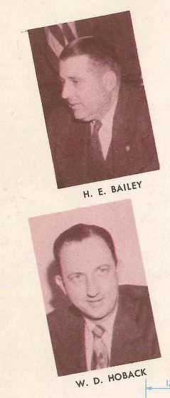
I also learned that the H.E. Bailey turnpike, which I have driven many times from Oklahoma City to Lawton, was named after the engineer who was once the General Manager of the Oklahoma Turnpike Authority, and the Turner’s Hoback Plaza near Stroud was named for the authority’s former Chief Engineer.
The Turner Turnpike has gradually evolved over my lifetime. By 1997, the grassy center median had been completely replaced by concrete barriers. In 2017, 17 miles of the turnpike from the Tulsa end were widened to six lanes with lighting along the median and enough right of way purchased to allow even more lanes to be added in the future, such as truck-only lanes. Eventually the entire turnpike will be similarly widened to handled the ever-increasing traffic, but for now that project is, like many previous turnpike projects, stuck in the courts.
The original toll for a two-axle vehicle was $1.40 one-way, which would would be $15.72 in early 2023 when adjusted for inflation; the actual toll these days is $5 or less. Some people complain how the turnpike was supposed to become a free road after being paid off in 1991, but in 1954 cross-pledging began where any new work on the state’s system of turnpikes is paid off from tolls collected on all of them, and there are now a dozen state turnpikes. I don’t expect any of them to ever become free roads. If they did, they wouldn’t be maintained well.
The Turner Turnpike once included multiple rest stops as well as service plazas. Howard Johnson’s won the restaurant concession. The most prominent was built at mid-way near Stroud on the eastbound side, with an enclosed pedestrian overpass to a parking lot on the westbound side. Howard D. Johnson himself was at its opening in 1953 along with Phillips 66 dignitaries.
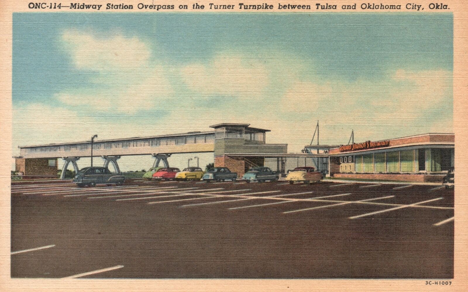
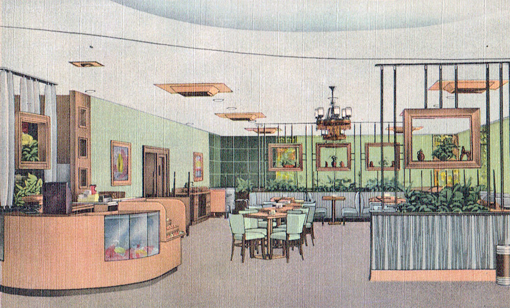


There were also four counter-service cafes linked with Phillips 66 gas stations at Heyburn and Chandler. Phillips built the service areas and sublet the restaurant spaces to HoJo. The Howard Johnson chain peaked in the 1960s, but I have no memories of visiting them. Some of the smaller HoJo stops later became Stuckey’s, with a barrage of highway signs about pecan rolls and the like, but we seldom stopped at those, either.
My father did enjoy having coffee while driving to Tulsa, always packing a long green thermos. We sometimes pulled over at a small rest stop for him to take a sip. He sometimes wanted to enjoy some cheese and crackers, but my mother and I were always raring to keep going until we reached Tulsa where we could have lunch at a restaurant.
In 1985, the old HoJo near Stroud was slated for demolition and the midway service plaza was reworked into the Hoback Plaza, situated in an enlarged center median, with a McDonald’s and a separate gas station and convenience store. Now that plaza is only a stop for westbound traffic. For eastbound traffic, a new Chandler service plaza opened in 2020 with a McDonald’s, Back Forty BBQ, and EZ Go fuel and convenience store.

In 1970, 18 emergency telephones were installed at nine locations along the turnpike. If you lifted the handset, a light would flash in the nearest toll booth indicating the location, and the attendant could answer. As a child, I was reassured to see them along the road, although by 1988, only one of them was actually working, and all of them were eventually removed.
There were manned toll booths at most entries and exits. The driver was handed a long IBM-style punch card. My father would often stow it behind one of the car’s sun visors. When exiting at a later toll booth, the card was given to the attendant, who would insert the card in a machine to ring up the charge and then tear off a perforated end which became your receipt.


I was fascinated by the punch cards, wondering what the various holes represented to the machine. My parents had to keep an eye on me to ensure I didn’t play with the card so much that the perforated receipt end would come loose.
The high cost of manning the toll booths 24 hours a day kept the number of turnpike entrances down. Originally there were only entrances at Oklahoma City, Chandler, Stroud, Bristow, Sapulpa, and Tulsa.
The Legislature approved a toll gate for Luther near OKC in 1971, but that was only built when the Kickapoo Turnpike came along in 2020. Years earlier an unmanned gate was added at Wellston to provide access to Route 66, making it easier to reach Arcadia east of Edmond with its historic round barn and Pops Soda Ranch. A gate was also eventually added at Kellyville in the eastern portion of the turnpike.
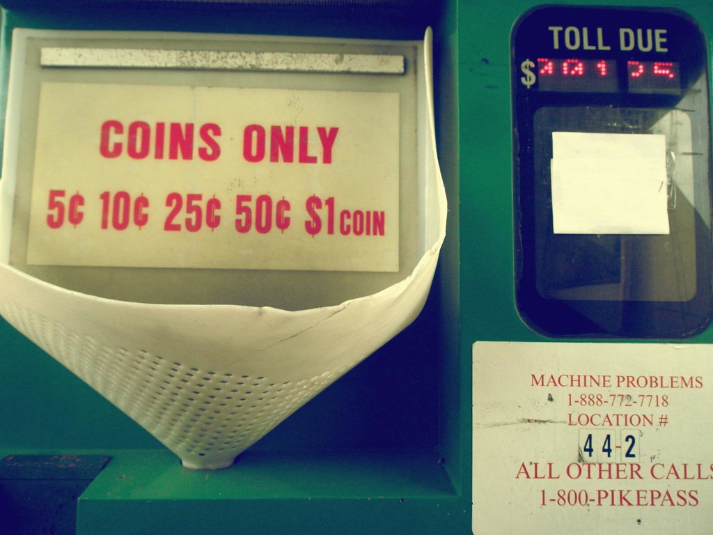
PIKEPASS, an electronic toll collection system, was initiated in 1991. It originally had a large transponder in a yellow plastic box that you affixed to the windshield with Velcro. Later boxes were white and smaller, and eventually those were replaced with small radio frequency identification stickers. I was gratified as the state gradually upgraded its turnpikes with dedicated PIKEPASS lanes which did not require one to slow down at all when zipping by a toll plaza.
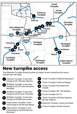
In 2024, the Turner will go cashless and the last manned toll booths will close. The state already installed cameras for PlatePay along eight other turnpikes. They photograph drivers’ license plates with invoices sent to each vehicle’s registered owner. Since they will no longer need to man or maintain toll booths, the plan is to add entrances at N 3505 road at Davenport, S 481st Street at Depew, Post Road near Arcadia, Highway 102 at Wellston, Highway 16 near Bristow, Route 66 near Heyburn, and Highway 99 in Stroud.
It will be interesting to see access increase along the Turner from the original six points to sixteen. Little towns along Route 66 like Davenport and Depew, which withered after the turnpike opened, will see some impact, although I’m not sure if it will help as much as some might hope.
After I moved to Bartlesville in 1989, my journeys along the Turner continued for visits with my parents in Oklahoma City until 2022, when Dad passed away and Mom moved to Bartlesville. Now my trips along the Turner have been sharply curtailed. As for Route 66, I only took it the entire way between Tulsa and Edmond a few times over the decades, although after Pops Soda Ranch opened in 2007, I did occasionally travel along 66 from Edmond to Wellston.
Tulsa
On our trips to the cabin, we would reach Tulsa and drive along what was called the Skelly Bypass. Its first segment, from the Turner Turnpike to Utica, opened in 1953, and the entire bypass along the southeast edge of the city was finished by 1958. Its four-lane bridge over the Arkansas River was the first four-lane highway bridge in the state.

The bypass was named for Tulsa oilman W.G. Skelly. Skelly Drive had no median in those days, just a chain link fence down the middle. The perils were obvious, even to a child. Skelly Drive was notorious in other ways. Highway department employees later testified that they had faked lab tests of construction materials to accept items that did not meet specifications. Some items were double-billed, and private engineers who checked the road found over a half-million dollars in overpayments. A state highway commissioner from Claremore was charged with receiving kickbacks on sod. Those charges were dismissed on technicalities, but in typical Oklahoma fashion there is still a bridge in Catoosa named in his honor.

We often stopped in Tulsa for lunch. I remember stopping at an El Chico at 51st and Lewis. I also remember us pulling into a shopping center and my father going to one restaurant, my mother to another, and me ordering something at Across the Street and then us all meeting back up to eat our respective meals. I felt very mature getting to go to a restaurant and order by myself. Across the Street was a chain of restaurants where you ordered your food from a telephone in the booth.
The Will Rogers Turnpike
A second turnpike from Tulsa to Missouri was completed in 1957, and a year later the Will Rogers Turnpike and the Turner Turnpike were designated as part of Interstate 44. Like the Turner, the Will Rogers had a restaurant near its midway point, but it was even more impressive.

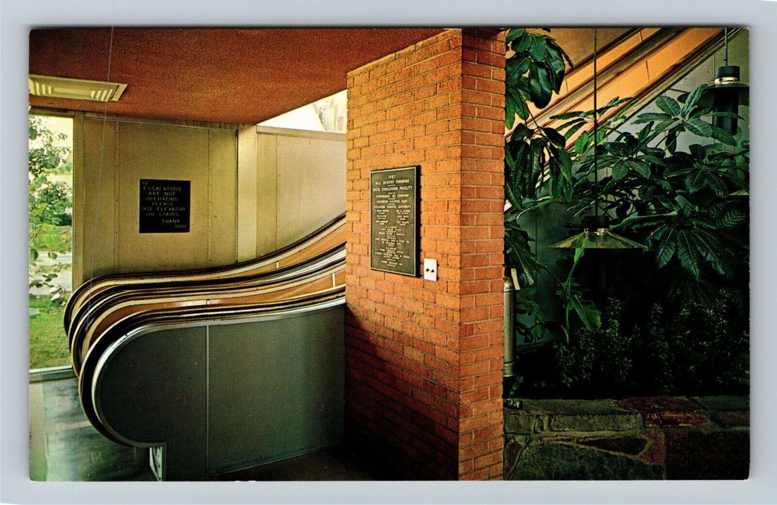
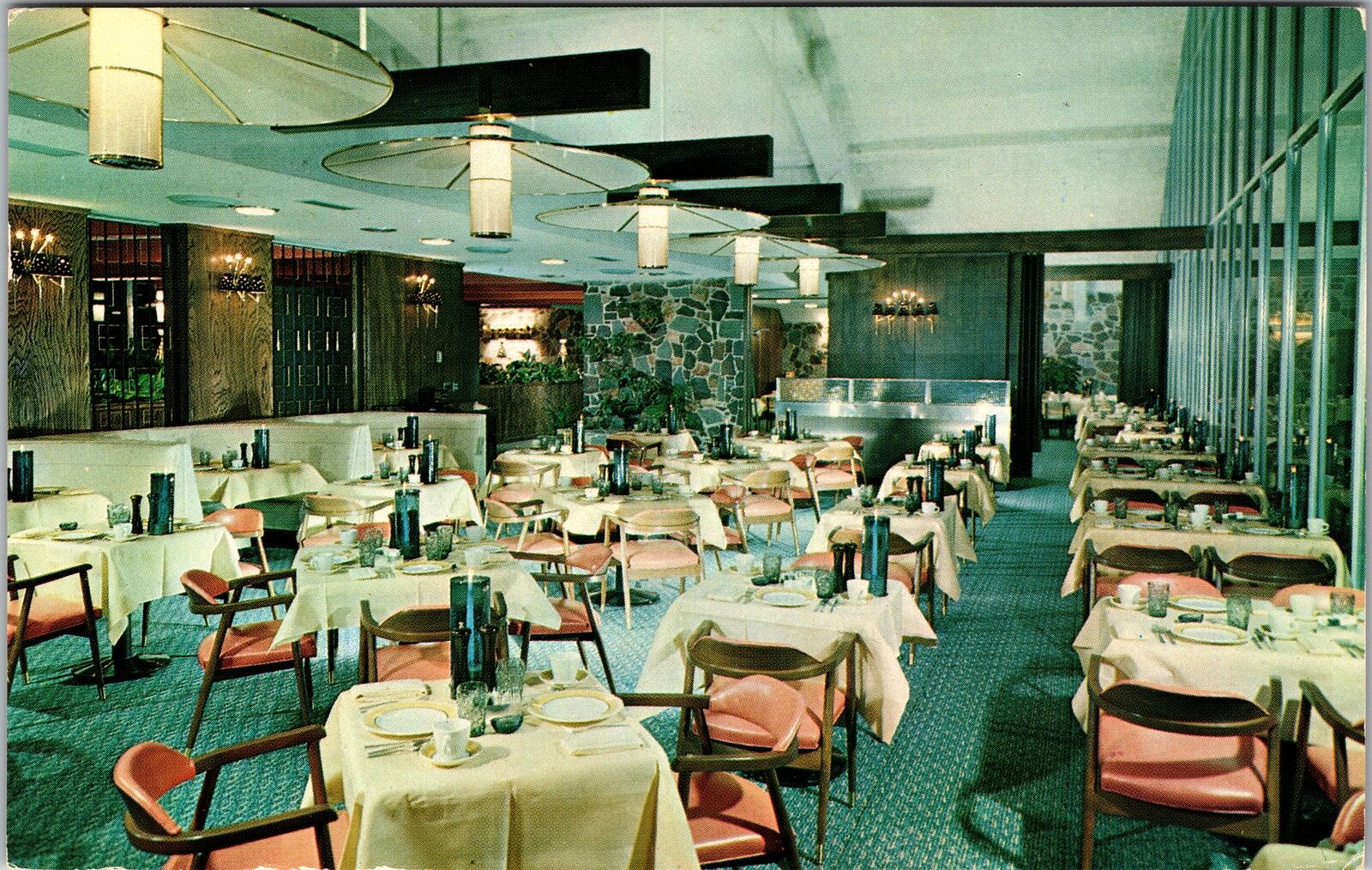

The Glass House Restaurant was built directly over the turnpike just southwest of Vinita, with full-service gas stations on each side initially operated by Conoco. It was the first bridge restaurant in the world and featured escalators that carried you up to a large restaurant that occupied over 20,000 square feet. It once had large aluminum shutters that used to turn throughout the day to shade the interior.
I thought it was nifty, although we didn’t stop there to eat very often. One time we ate there, we were all in shorts and it was very cold inside. We spread cloth napkins over our laps to stay warmer, and resorted to grabbing napkins off other tables to get more coverage.
In the mid-1970s, it became a Howard Johnson restaurant and later became the world’s largest McDonald’s of its day, although that was a bit misleading since the actual restaurant was normal-sized and they were counting the entire building which also had a souvenir shop, ice cream vendor, etc.
The facility was renovated in 2013-2014 and renamed the Will Rogers Archway, with a McDonald’s, a Subway, and Kum & Go convenience store and gas station. After I moved to Bartlesville in 1989, I would take US 60 eastward to visit the Ozarks, only popping onto the Will Rogers Turnpike between Vinita and Afton. The Glass House/Archway is southwest of there, while I was always headed northeast. So I haven’t visited it in many years.

Afton
We would exit the turnpike at the Afton exit, although Afton is southwest of there, and we almost always proceeded east on U.S. 60. A few times, however, my parents agreed to dip south to old Route 66 to take me to the Buffalo Ranch.


Russell and Aleene Kay opened it in 1953, with live buffalo, llamas, yaks, and peacocks roaming the grounds. There was a covered wagon and a stuffed buffalo you could sit on for a photo, and of course many souvenirs. They also served buffalo burgers, hamburgers, and hot dogs. The tourist trap closed in 1997 and is now just a convenience store.
The Rest of the Route
We rarely drove past the Afton exit on I-44, let alone Route 66. 66 heads up to the mining district around Miami and clips the southeastern corner of Kansas, while I-44 ducks into Missouri just barely missing an entry into Kansas. Route 66 and I-44 then roughly parallel each other onward northeast across Missouri to St. Louis. There I-44 terminates, while old 66 continued on to Chicago. A new freeway opened across Illinois in 1957 as a realignment of US 66, gaining the designation of I-55 in 1960.
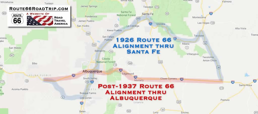
As for tracing 66 west from Oklahoma City, Interstate 40 closely follows old 66. Wendy and I often travel along I-40 through Amarillo and past Tucumcari and Santa Rosa, New Mexico, but we seldom continue onward to Albuquerque, instead veering northwest to Santa Fe. The original 1926 alignment of 66 also veered off to the beautiful capital of New Mexico, but it was rerouted in 1937.
As for whether to travel what remains of Route 66 versus the various interstates, it’s your choice. There are lots of online resources about the various attractions along the way. Just bear this in mind:
Thanks to the Interstate Highway System, it is now possible to travel across the country from coast to coast without seeing anything.
Charles Kuralt


This is a wonderful bit of history. Thanks for sharing
Wow!! Going to save this. Being of a certain age I remember all of it. What great memories this brought back.