A Grand Adventure, Days 1 & 2: From Cadillac Ranch to TinkerTown

TRIP DATES: June 9-10, 2017 | SLIDESHOW | PHOTO ALBUM
Dad and his camper in 1991 on our trip out West

Over a quarter century ago my father and I went west in his Volkswagen camper, with him showing me highlights of central New Mexico, southwestern Colorado, and Arizona. In 2013 and 2014 I took Wendy to some of the sites in New Mexico and Colorado, such as the Durango-Silverton railroad, the ruins of Mesa Verde, and Sandia Crest above Albuquerque. But we never made it all the way west to Arizona, so she had never visited the incredible Grand Canyon. My friend and colleague Betty Henderson and her husband, John, had also never visited that natural wonder. That led me to formulate a plan.

In July 2017 I’d be taking up an administrative job, giving up the traditional summer break of a classroom teacher. So I proposed that the four of us travel west in June to see the Grand Canyon and other sites along the route. Betty and John drove separately so that they could head back home after a week on the road, while Wendy and I would remain in Santa Fe, New Mexico for a few extra days. On June 9, 2017 we set out on a journey of over 2,500 road miles, with the far point being the Grand Canyon, over 900 air miles from home.

Click map to enlarge

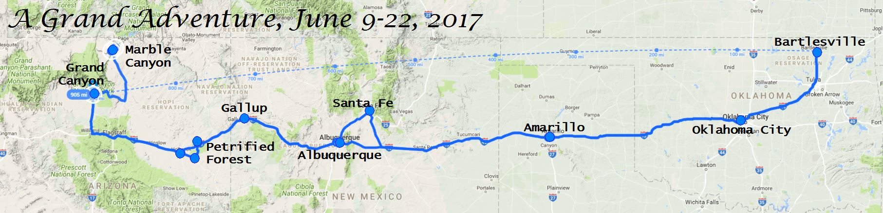
Our first stop was in Oklahoma City to have lunch with my parents, who are now 80 and 92, respectively. As usual, I kept my iPhone’s FollowMee app on throughout the vacation, allowing my parents to track our progress and vicariously enjoy our trip. Then the Hendersons followed Wendy and me westward on I-40, the successor to much of the famed Route 66. Our first overnight stop would be in Amarillo.

We pulled into Amarillo for a late and disappointing dinner at the Calico County restaurant we had enjoyed so much on previous trip. Thankfully it redeemed itself with tasty breakfasts when Wendy and I came back through the cowtown twelve days later. We spent our first night at the Drury Inn & Suites, a very nice facility even if the smell created by Amarillo’s livestock wafted into the lobby from time to time.

Cadillac Ranch

Our second day on the road featured our first tourist attraction, the Cadillac Ranch just outside of Amarillo. As usual, visitors were milling about, spray painting the old cars and taking photographs.

Texas Kion

Wendy had brought a little Kion squeezable figurine with her on the trip, but it didn’t take much of my driving for her to squeeze him so much he burst, necessitating a bandage. Little Kion had stopped with us in Groom, Texas during our first day on the road, showing no fear of The Dreaded Red Tigers. While we were at Cadillac Ranch, he hopped on top of one of the wheels, which were encrusted with over 40 years of paint.

Lunch was at the venerable Joe’s Bar & Grill Cantina in Santa Rosa, a place John had visited with a railroad crew years ago. I avoided the chile sauce on my burrito, but enjoyed filling my sopaipilla with honey.

Elvis at Russell's Travel Center

I made sure to stop every hour or so throughout our road travels to give everyone a break. So we stopped in many tourist traps, including Russell’s Travel Center in Endee, New Mexico. Elvis was there alongside a pink cadillac. There weren’t any Stuckey’s along our route, but their Pecan Log Rolls were present, for better or worse.

Clines Corners is the stop on I-40 where Wendy and I usually angle northwest to Santa Fe. Wendy used products from there to outfit Kion with a cowboy hat for Texas and a sombrero to shield him from the strong New Mexico sun.

It was warm throughout most of our vacation, with the exception of a cooler and windy first day at the Grand Canyon. Everyone’s nasal passages dried out in the desert, and Wendy and I were happy to feel the moisture of Green Country upon our return home.

TinkerTown

TinkerTown Museum Exterior

Instead of angling up to Santa Fe at Clines Corners, we drove on west to Albuquerque. We had never been to TinkerTown on the east slope of Sandia Peak, so I led us there to explore the odd structure and admire the wacky and obsessive creations of the late Ross Ward. His motto to “Live Life as the Pursuit of Happiness” was evident in his plethora of dioramas.

TinkerTown Diorama
TinkerTown Sideways Looks

Wendy had a hoot laughing at the expressions on the faces of various figures, including various wagon drivers, politicians at a seamy hotel, bar folk, characters in an ice cream parlor, coffee drinkers, folks at a burial, a Native American family of sideways glances, the Dukes of Hazzard with a wagon rather than the General Lee race car, and general street folk.

A large circus diorama reflected how Ross Ward was a show painter for carnivals for 30 years. Wendy found one of my heroes, Alfred Hitchcock, lurking in a graveyard near TinkerTown’s animated hell, and we found a display depicting teachers on summer vacation, although I think they went to the beach rather than the desert.

Mark Twain's Observations

I appreciated how Mr. Ward highlighted Mark Twain’s sentiment on travel:

Travel is fatal to prejudice, bigotry, and narrow-mindedness, and many of our people need it sorely…broad, wholesome, charitable views…cannot be acquired by vegetating in one’s little corner of Earth.

That comes from Innocents Abroad, which is a great free read if you like travelogues.

Some walls of the ramshackle buildings were built of bottles, showing the influence of Grandma Prisbey’s Bottle Village out in California. There was even a Buddha bottle shrine. Outside, the Hendersons explored Buzzard Gulch, a collection of rusting equipment of the west. Wendy posed for me as Miss TinkerTown.

TinkerTown Jeep

I was touched to find that a Jeep coated in coins, paint, pebbles, and figurines was a project his wife suggested to Ross after his Alzheimer’s symptoms made it unsafe for him to drive. He had been diagnosed with the disease in his late 50s and died in his early 60s. His daughter, Tanya Ward Goodman, wrote a well-received book about his dilemma.

Up to Sandia Crest

Three years back, Wendy and I rode the tram to Sandia Crest, and we still laugh about how the guide pronounced “mountain” as “mou-ann” during our ride. This time the Hendersons joined us in scaling the peak in our respective Toyota Camrys on a long series of switchbacks up the Sandia Crest Scenic Highway.

The many switchbacks of the road to Sandia Crest
Hendersons on Sandia Crest

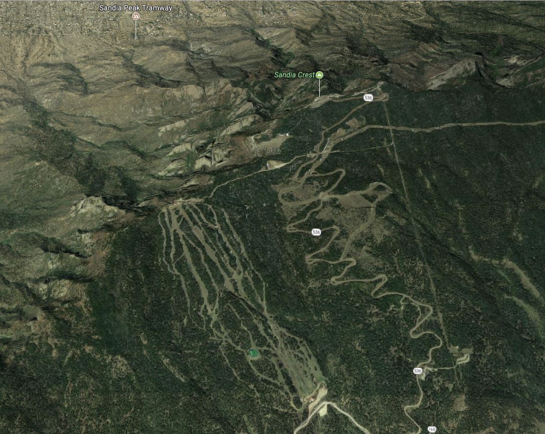
Betty and John posed for me up top, with Albuquerque fading into the haze below us and the mountain ridge sloping off to the side.

The altitude at Sandia Crest and New Mexican food at Santa Rosa took their toll on Wendy and me, with us crashing at the hotel near Albuquerque’s Old Town while the Hendersons enjoyed dinner at the St. Clair Bistro.

The next day would bring another long drive west on I-40 from Albuquerque through the north end of the Petrified Forest to Tusayan, just south of the Grand Canyon.

SLIDESHOW | PHOTO ALBUM

A Grand Adventure, Day 3: The Petrified Forest >

Posted in photos, travel, video | Leave a comment

We live in a world with tears

I lost one of my mentors tonight. We had not spoken in years, yet he was and remains, as my wife put it, one of the pieces of the puzzle that is me.

I cried when I learned a few days ago that he was very ill and would soon be going home to die. I mailed a letter to his home, knowing he would likely never get to read it or hear it, but at least his wife and family might receive my acknowledgement of the gifts he shared with me. I wanted them to know his light is not extinguished, for it still shines in me and the many others he supported and tutored.

My letter will arrive there in a day or two. But two late is too late. I have been too preoccupied with my busy life to keep track of his. So now regret burns a hole in my heart even as fond memories flood down to fill it.

My wife can tell you I do not track all that well the lyrics in many songs. But for sad songs I often do, and tonight is a dark night for me. A night for a sad song from Lucinda Williams in which every word speaks to my tears, my skin, my bones.

We live in a world with tears, and I suppose that is for the best. Like time, they are a great teacher. Rest in peace, Stephen Merton Sutherland, and thank you for being a piece of this puzzle.

If we lived in a world without tears
How would bruises find
The face to lie upon
How would scars find skin
To etch themselves into
How would broken find the bones

If we lived in a world without tears
How would heartbeats
Know when to stop
How would blood know
Which body to flow outside of
How would bullets find the guns

If we lived in a world without tears
How would misery know
Which back door to walk through
How would trouble know
Which mind to live inside of
How would sorrow find a home

If we lived in a world without tears
How would bruises find
The face to lie upon
How would scars find skin
To etch themselves into
How would broken find the bones

If we lived in a world without tears
How would bruises find
The face to lie upon
How would scars find skin
To etch themselves into
How would broken find the bones

How would broken find the bones

Posted in music, random | Leave a comment

Overlooking Lake Leatherwood

March 16, 2017 | PHOTO ALBUM | SLIDESHOW

A year ago, Wendy and I visited Lake Leatherwood for the first time, circumnavigating the lake on a four-mile hike on the Beacham Trail. Wendy had enjoyed searching for rocks with crystals along a creekbed at the northwest end of the lake. We made plans to return later for her to search the creekbed for more rocks while I hiked the nearby Overlook Trail. A year later, it was time to implement our plan.

Lake Leatherwood Trail Track

We drove over to the lake and walked up its western side on the Beacham Trail, diverting to the Fuller Trail to reach the creekbed. Wendy began searching for crystals while I returned south on the Point Trail to take the Beacham Trail over to the north end of the Overlook Trail.

The full trail is about two miles long, rising steeply at either end to run along a bench over 300 feet above the lake. The trail climbed steadily up the hillside, passing through a grassy area on its way through the woods. It climbed to about 30-50 feet from the top of the mountain.

The view of the lake from the overlook was obscured by trees and would be hopeless once they leafed out.

From the overlook
Mossy table

The bench trail running southwest from the overlook was quite nice. It featured exposed layers of rock, often smothered in green moss. The leaves covering the ground parted to expose the rocky trail and the large tables and benches of mossy rock.

I did not want to follow the Overlook Trail its full length, as that led over to Mulladay Hollow and would mean a long walk along the road back to the Beacham Trailhead. So I took a connector trail that led straight down the hillside from the Overlook Trail to the trailheads for the Beacham, Fuller, and lakeside trails.

There I opted to start my return north on the Fuller Trail, rather than the Beacham, but crossed over to the latter so that I would end up at the west end of the creekbed Wendy was exploring. Sure enough, I found her not too far from the end, eagerly hunting for crystals.

Triple threat

I joined in the hunt. Wendy found a number of rocks with embedded crystals, and I’m glad to say that I was able to contribute a find or two to her collection. The different colors of crystal and surrounding rocks made for a nice display back at home.

Collection

We began to carry our finds out on the Beacham Trail, but diverted halfway along to the lakeside trail. That way I could say that I’ve walked almost all of the trails on the west side of the lake, leaving many more trails to explore south of there.

Ash Cave Rock

Wendy is such a good rock hound that, a day later, she even found a rock with embedded crystals at Ash Cave, a party spot north of Cassville that has been scoured over for decades. Many flint chips and arrowheads were dug out of that cave decades ago, including an excavation by Dr. Charles Peabody of Phillips Academy at Andover in 1915 which found flint and stone implements, a few bits of crude pottery, and many animal bones, with all of the large ones cracked to get at the marrow, in the ash bank that once graced the front of the cave.

We look forward to return trips to stay at Sugar Ridge, including more hiking and rock hunting at Lake Leatherwood along with a park we’ve not yet visited, Black Bass Lake.

PHOTO ALBUM | SLIDESHOW

Posted in day hike, photos, travel | Leave a comment

Butler Hollow to Radium Hollow

March 15, 2017

For Spring Break 2017, Wendy and I returned to Sugar Ridge Resort on Arkansas’ Beaver Lake for a few days of relaxation. We first stayed there in June 2014, and it has been our Spring Break destination for each subsequent year. This time our usual cabin, #6, was booked, so we stayed at the almost identical cabin #2. Wendy had fun feeding the birds on the balcony, attracting a number of cardinals.

Back in April 2014 Wendy found a lovely small geode near Onyx Cave along the Sugar Camp Scenic Byway west of Eagle Rock, Missouri. (Not to be confused with the nearby commercial cave in Arkansas.) We decided to return there so she could scour the trail area for more pretty rocks.

Butler Hollow

In planning the outing, I mapped out a scenic drive from Sugar Ridge to Onyx Cave via Butler Hollow. For the uninitiated, “hollow” is a term used in New England, Appalachia, and the Ozarks for narrow valleys formed by streams running through mountainous regions, à la The Legend of Sleepy Hollow. Ozark hillbillies call them hollers.

The old Missouri and North Arkansas railway once followed Butler Hollow from Seligman, Missouri to Beaver, Arkansas. My great-grandmother Caldona Tennessee Burnett, who was called Dona, surely traveled this route, albeit not by train, since she was born near Beaver and married James Washington Weston in Seligman. My grandmother Effie was born in a log house her father built on Dona’s father’s place near Seligman.

Our scenic drive to Onyx Cave

Wendy and I drove northeast on state highways from Sugar Ridge to Butler Hollow. But instead of turning right to follow Highway 187 southeast to Beaver, we turned northwest, taking the gravel Farm Road 2285 up the hollow into Missouri until we could turn back east on FR 2280 to reach FR 2270, which is the gravel section of the Sugar Camp Scenic Byway.

We noticed some signs as we drove along Butler Hollow about “saving” the hollow. A later web search revealed that some residents opposed a forest service plan to restore glades in the area via logging, cedar tree removal, and rotating controlled burns. The forest service eventually adopted a plan that scaled down the project from 18,000 to about 3,600 acres; it is Alternative 4 in their online plan. The plan will now address Chute Ridge directly east of Roaring River State Park over to Highway 86 along with Pine Hollow, which is just south of Roaring River State Park and north of the Sugar Camp Byway.

The adopted “Butler Hollow Plan” to thin and burn areas east and south of Roaring River State Park; Butler Hollow actually runs a few miles south of the bottom edge of this map

A few years back there was a controlled burn of Chute Ridge to remove the debris left behind by a cedar tree removal project. I strongly dislike the invasive cedars I see spreading across Missouri, Arkansas, Oklahoma, and Texas. Fire suppression has allowed them to flourish. I’ve seen over the decades the results of a small glade restoration project in Roaring River State Park where the Firetower Trail intersects Highway F. That highlighted for me how the forest in southern Missouri is now quite different from what it was 150-200 years ago. Back then it had fewer but larger oak trees, a canopy that was fairly closed, and a much more open forest floor. Cedars were uncommon, and glades were larger and more frequent.

1937 logging in what would become Mark Twain National Forest

My great-great-grandfather Nathaniel Meador arrived in Barry County, Missouri in 1849. That very year a survey of Butler Hollow in the southern part of the county showed no cedar trees and a large distance of 64 feet between trees. Before European settlement, fire swept the area on average every three years. Most of the area was logged in the early 20th century, with much of the pine and white oak removed. Open-range grazing with frequent burning became the norm until the Forest Service acquired the lands in the 1930s and 1940s, ending most agriculture. The second-growth forest is now dominated by eastern redcedar, black oak, and red oak rather than white oak and post oak.

The Forest Service would like to restore a fraction of the land to pre-settlement conditions, noting that the second-growth forest trees have reached maturity and are now in decline. Red oaks mature at around 60 years and by age 90 nearly all of them will show signs of decline. About half of the tree stands in the forest are now over 90 years old, and the other half almost entirely 50-90 years old.

I understand residents’ worries about the glade restoration project, with its periodic controlled burns and the use of herbicides to prevent cut cedars from returning. The compromise of a smaller project adjacent to the state park seems reasonable. It will be interesting to observe its outcomes in the coming decades.

Radium Hollow

Wendy and I navigated the gravel roads along and up from Butler Hollow without incident, reaching the Onyx Cave picnic area in the late afternoon. It overlooks Radium Hollow, so named because its Radium Spring produces water with detectable radioactivity from particles it picks up in the Chattanooga Shale it flows over.

There is a very tall tale of the discovery of a radium cave in the area. Back in the 1920s Douglas Cloe is said to have bottled five-gallon jugs of the Radium Spring water for its supposed medicinal properties, and in 1950 a group reportedly surveyed the area with an eye toward uranium mining. None of that panned out, but below are photos I found online of the former radium mine and a concrete water tank nearby. Today the hollow to the east of the spring is the site of the Eagle Rock Retreat Christian camp.

Onyx Cave Trail Track

Onyx cave is sealed off

A trail leads down the west hillside from the Onyx picnic area on the Sugar Camp Byway to a blocked-off crawlway called Onyx Cave. It reportedly goes back into the hillside about 100 feet. Wendy and I hiked about half a mile at the site, searching the trail and surrounding hillside for pretty rocks. While she didn’t find any more geodes, Wendy the rockhound still had fun. I joined in the search but also slammed rocks together to break them open and observe their interiors, which were sometimes quite different in appearance from their exterior rind.

We didn’t find much; Wendy would acquire many more rocks with crystals the following day when we returned to Lake Leatherwood, with her hunting rocks in a creekbed while I hiked an overlook trail. That will be the subject of the next blog post.

Our scenic loop

Leaving Onyx Cave, we dropped north out of the forest via FR 2265 and 1162 to make our way across Roaring River and past Munsey Cemetery to reach Highway F. From there we made a dash through Roaring River State Park to Cassville for some supplies before returning to Sugar Ridge via state highways. The loop we ended up making vaguely resembled a north-pointing arrowhead.

It was a fun outing, and someday we might return and venture down the side road off the Sugar Camp Scenic Byway (visible in satellite imagery but not shown in road maps) to Radium Spring.

Posted in day hike, photos, travel | 6 Comments

Standing Bear: “I am a man”

In January 2017, Wendy and I traveled to Ponca City to enjoy the Mexican food at Enrique’s restaurant. As we drove through town, we spied a large statue of a Native American just north of the Phillips refinery. Intrigued, we drove into Standing Bear Park. We found an elaborate trail with large sigils of various tribes, leading us to the 22-foot bronze statue of Standing Bear, gazing out across the land.

You need to know the story of Standing Bear

So who was Standing Bear? He was a Ponca Indian, of course, and he was the first Indian to be recognized as a person under the law of the U.S. Constitution. His tale is worth your time.

Three Tragic Treks

The story of the Poncas is, like so many tales of Native Americans forced to relocate to Oklahoma, a tale of greed, arrogance, and destruction. The tribe once lived along the Atlantic coast, moving sometime before 1500 C.E. to what would someday become Minnesota. Attacks by the Sioux led them to resettle between the Missouri and Niobrara rivers in what is now northern Nebraska and South Dakota.

Standing Bear was born there around 1830. In 1858, the Ponca signed a treaty giving up most of their land but allowing them to keep a small part by the Niobrara River in exchange for schools, mills, and thirty years of annuities. In 1865 they relinquished more land to gain access to their old burial grounds. But in 1868 a treaty with the Lakota nation mistakenly included the Poncas’ land in the Great Sioux Reservation. Brutal attacks by the Sioux led the Ponca chiefs to sign a document in 1875 which they thought meant they would live among the Omaha, their allies, on a Nebraska reservation. But the government used it to force their relocation six hundred miles south to Indian Territory, which is now part of Oklahoma.

The Poncas’ own Trail of Tears

In February 1877, ten Ponca chiefs, including Standing Bear, were taken to Indian Territory to select land. Unhappy with the stony and malarial land, they refused to choose. The government agent angrily abandoned them, leaving them without an interpreter, food, money, or documentation. So Standing Bear and seven other chiefs walked the six hundred miles back home, arriving in northern Nebraska with bare and bloodied feet, their moccasins having worn out after the first ten days of their trek.

In May all of the Poncas were forcibly removed. At the point of a bayonet, 523 individuals, including Standing Bear, set out with whatever they could carry. By the time they arrived near Baxter Springs, Kansas, nine of them had died, including Standing Bear’s daughter Prairie Flower.

Bright Eyes

Arriving too late to plant crops, they were left in the new country for months without rations or promised farming equipment, and more than one third of them died of starvation and malaria. Among these was Standing Bear’s sixteen-year-old son, Bear Shield. The middle-aged chief had promised his son before he died that he would return his body to their home in Nebraska to be buried among his ancestors.

So on January 2, 1879, in the depths of a harsh winter, the aging chief and 26 other Poncas set out for Nebraska with the body of his son. Two months later, they arrived at the reservation of the Omahas, where Chief Iron Eye and his daughter Bright Eyes gave them food and shelter. She would prove instrumental in helping Standing Bear win back his freedom.

A Plan for Justice

General George Crook

Thomas Henry Tibbles in his old age; he was 39 at the time of the trial


Meanwhile, the Secretary of the Interior had telegraphed General George Crook of Omaha, ordering him to arrest the wayward Poncas and return them to Indian Territory. Crook, noted for his exceptional service in the Civil War and Indian Wars, privately disapproved of the government’s policies toward Indians and felt the Poncas had been treated unfairly. He secretly spoke with Chief Iron Eye and Bright Eyes and formulated a plan.

Crook met with former abolitionist and minister Thomas Henry Tibbles, an editor of the Omaha Herald newspaper. He asked for Tibbles to assist the Poncas:

If we can do something for which good men will remember us when we’re gone, that’s the best legacy we can leave.

-General George Crook

John Lee Webster & Andrew Jackson Poppleton argued the case for Standing Bear’s release

Tibbles publicized the situation, and attorney John Lee Webster offered his services pro bono, joined by Andrew Jackson Poppleton, the chief attorney of the Union Pacific Railroad. General Crook discreetly suggested they seek a writ of habeas corpus for Standing Bear’s right to be released and return to his land. The government was not pleased: Indian Affairs Commissioner Ezra Hayt declared, “No attorney has the right or can appear for an Indian, until authorized to do so by the Indian Department.” But the trial proceeded in May 1879 in the court of District Judge Elmer Scipio Dundy.

Standing Bear with his surviving family

When questioned, Bright Eyes translated for Chief Standing Bear:

I wanted to go on my own land, land that I had never sold. That’s where I wanted to go. My son asked me when he was dying to take him back and bury him there, and I have his bones in a box with me now. I want to live there the rest of my life and be buried there.

Who is a man? Who is a citizen?

Webster and Poppleton argued that the Fourteenth Amendment to the U.S. Constitution, which grants citizenship and equal protection and due process of the law to all persons born or naturalized in the United States, applied to all Indians. The government relied on the notorious case of Dred Scott v. Sandford to argue that an Indian was not a citizen and not entitled to sue in its courts.

Standing Bear

After the legal proceedings had ended, the judge broke from routine and allowed Standing Bear to stand up and address the court.

I see a great many of you here. I think a great many are my friends. You see me standing here. Where do you think I came from? From the water, the woods, or where? God made me and he put me on my land. But I was ordered to stand up and leave my land. Who the man was I don’t know. He told me to leave, and I had to go. It was hard for me to go. I objected to going. I looked around me for someone to help me, but I found none. Now I have found someone, and it makes me glad.

When I got down there it seemed as if I was in a big fire. One hundred and fifty-eight of my people were burned up; now I stand before you. I came away to save my wife and children and my friends. I never want to go there again. I want to go back to my old reservation to live there and be buried in the land of my fathers. If I can go there I may live some time longer.

He turned to Judge Dundy, and stretched out his right hand from beneath a red and blue blanket, saying:

That hand is not the color of yours, but if I prick it, the blood will flow, and I shall feel pain. The blood is of the same color as yours. God made me, and I am a man. I never committed any crime. If I had, I would not stand here to make a defense. I would suffer the punishment and make no complaint.

That hand is not the color of yours, but if I prick it, the blood will flow, and I shall feel pain. The blood is of the same color as yours.

Then he looked out of the courtroom window into the distance, and continued:

I seem to be standing on a high bank of a great river, with my wife and little girl at my side. I cannot cross the river, and impassable cliffs arise behind me. I hear the noise of great waters; I look and see a flood coming. The waters rise to our feet, and then to our knees. My little girl stretches her hands toward me and says, ‘Save me.’ I stand where no member of my race ever stood before. There is no tradition to guide me. The chiefs who preceded me knew nothing of the circumstances that surround me. I hear only my little girl say, ‘Save me.’ In despair I look toward the cliffs behind me, and I seem to see a dim trail that may lead to a way of life. But no Indian ever passed over that trail. It looks to be impassable. I make the attempt.

I take my child by the hand, and my wife follows after me. Our hands and our feet are torn by the sharp rocks, and our trail is marked by our blood. At last I see a rift in the rocks. A little way beyond there are green prairies. The swift-running water, the Niobrara, pours down between the green hills. There are the graves of my fathers. There again we will pitch our teepee and build our fires. I see the light of the world and of liberty just ahead.

I see the light of the world and of liberty just ahead.

Judge Elmer Scipio Dundy

The old chief became silent. After a long pause, he turned back toward Judge Dundy, saying:

But in the center of the path there stands a man. Behind him I see soldiers in number like the leaves of the trees. If that man gives me the permission, I may pass on to life and liberty. If he refuses, I must go back and sink beneath the flood.

You are that man.

There was silence in the court as the old chief sat down. Tears ran down over the judge’s face. General Crook leaned forward and covered his face with his hands. Some of the ladies in the audience sobbed.

A few days afterward, Judge Dundy handed down his decision:

  1. That an Indian is a ‘person’ within the meaning of the laws of the United States, and has, therefore, the right to sue out a writ of habeas corpus in a federal court, or before a federal judge, in all cases where he may be confined or in custody under color of authority of the United States, or where he is restrained of liberty in violation of the constitution or laws of the United States.
  2. That General George Crook, the respondent, being commander of the military department of the Platte, has the custody of the relators, under color of authority of the United States, and in violation of the laws thereof.
  3. That no rightful authority exists for removing by force any of the relators to the Indian Territory, as the respondent has been directed to do.
  4. That the Indians possess the inherent right of expatriation, as well as the more fortunate white race, and have the inalienable right to ‘life, liberty, and the pursuit of happiness,’ so long as they obey the laws and do not trespass on forbidden ground.
  5. Being restrained of liberty under color of authority of the United States, and in violation of the laws thereof, the relators must be discharged from custody, and it is so ordered.

Years later, attorney Poppleton reflected on his final court plea for Standing Bear, “I cannot recall any two hours’ work of my life with which I feel better satisfied.”

The next year, Judge Dundy was part of a lower court panel which asserted that Indians who had left their tribes and submitted to U.S. jurisdiction were U.S. citizens, but this was rejected by the U.S. Supreme Court in 1884.

Free, but without a tribe

The Niobrara River

After the trial, Standing Bear was left in a legal limbo. The legal argument used to establish his right to freedom as a citizen had also severed his tribal alliance. He was no longer allowed to live on any reservation as a ward of the government. It took the service of Native Americans in World War I to finally shame the U.S. into accepting tribal members as citizens in 1924 and the country did not accept all native-born people as citizens until 1940.

So Standing Bear was effectively exiled to Niobrara River island, a small bump of land not claimed by the Sioux in their treaty with the U.S. Later that summer, he slipped back to the mainland with the bones of his son, burying him somewhere along the bluffs.

In the fall, Tibbles and Bright Eyes persuaded Standing Bear to join them on a speaking tour of the eastern U.S. to publicize the plight of the Poncas. Those two would go on to marry in 1881 and continued their struggle of defending Indian rights. After her death in 1903, Bright Eyes was the first woman eulogized in the U.S. Senate.

Standing Bear in 1906 outside his Nebraska home

The U.S. government finally recognized the Northern Ponca in 1881 and paid restitution, returning 26,000 acres of land, a small part of what had been stripped away. Many of the Poncas in Oklahoma choose to remain there by the Arkansas River.

Still unable to live on tribal lands, Standing Bear wandered for a decade until, in 1890, when he was in his 60s, he was granted 300 acres through the Dawes Act. He built a farmhouse by the Niobrara River and remained there until the end of his days, dying in obscurity in 1908. He was buried near the village of his ancestors.

Perhaps it would do us well to pause, as our nation debates the fate of illegal aliens and walls along its southern border, and contemplate where each of us would be today if the Native Americans had been able to keep out European settlers. Let us consider our nation’s long history of injustice towards Native Americans, women, people of color, homosexuals, and on down the long list of suffering, humiliation, and destruction. The American Experiment has been a long and troubled road to freedom, with far too many people lost on its trails of tears.

Posted in random, travel | Leave a comment