Honeymoon, Day 6: Astoria’s Riverfront

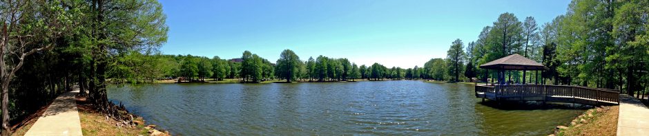
TRIP DATE: July 7, 2016 | SLIDESHOW | PHOTO ALBUM | Other Honeymoon Posts

Meador Post

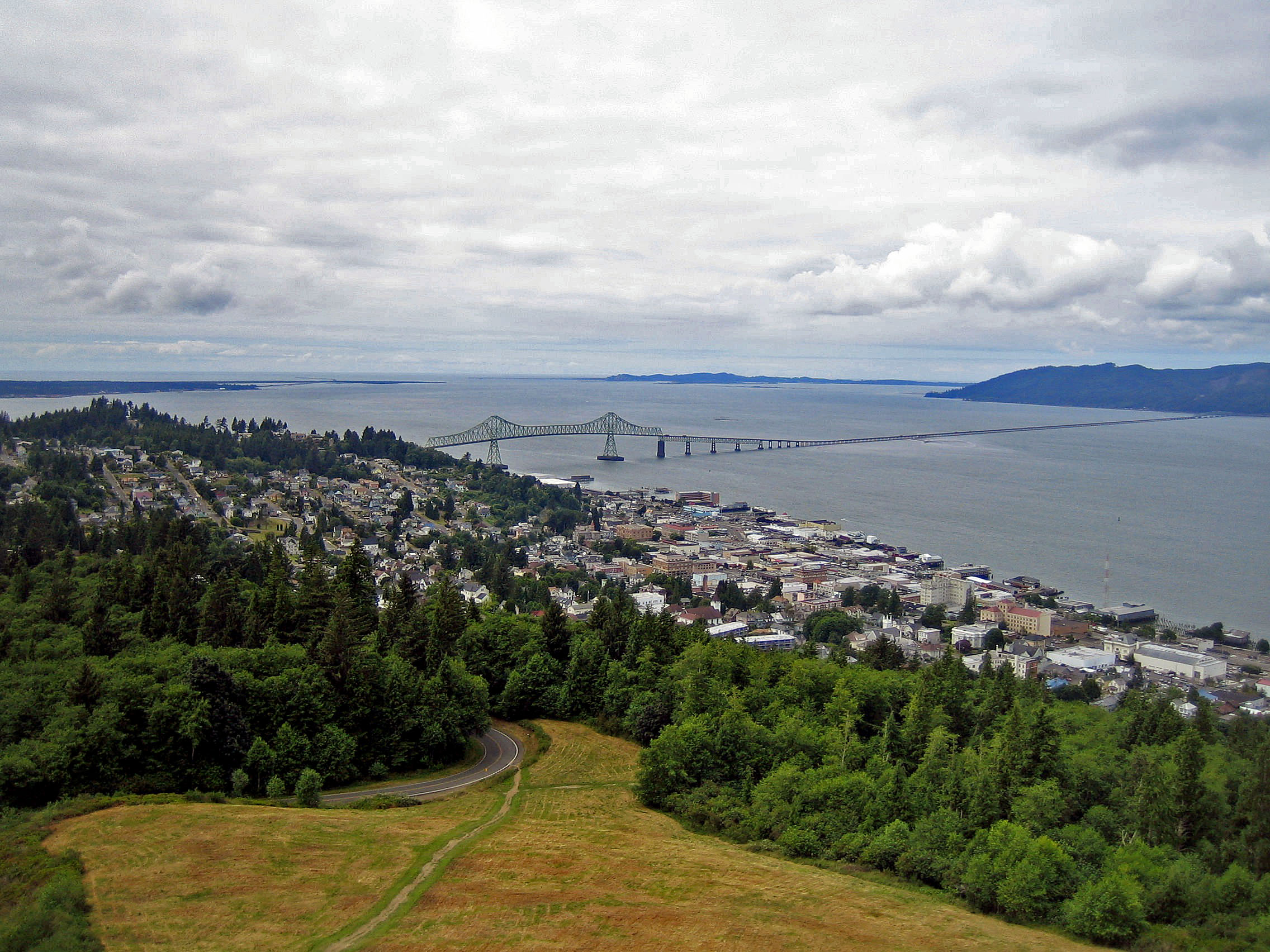
We relaxed for two days in Astoria at the mouth of the mighty Columbia. This little Oregon town of less than 10,000 has a picturesque setting, perched on the southern slopes above the river across from the State of Washington. Fort Astoria was established in 1811 as the first American-owned settlement on the Pacific coast, on land where the Clatsop Indians had lived for thousands of years.

astoria
I shot this view of Astoria a decade before returning on my honeymoon

Seven months earlier I had been riveted by Peter Stark’s Astoria: Astor and Jefferson’s Lost Pacific Empirewhich told of the harrowing seven-month journey westward of the Overland Astorians from St. Louis to what would become Astoria. Stark recounted how they suffered mightily going down and along the treacherous Snake River.

Amazingly, most of them made it to what would become Astoria, but the War of 1812 brought their enterprise to an end. On the return journey eastward they established the South Pass route which would become a key component of the Oregon Trail. About 200 years later Wendy and I jetted in first class comfort from Oklahoma to Oregon in only a few hours on our honeymoon; what a contrast.

cannery-workers
Chinese cannery workers in Astoria

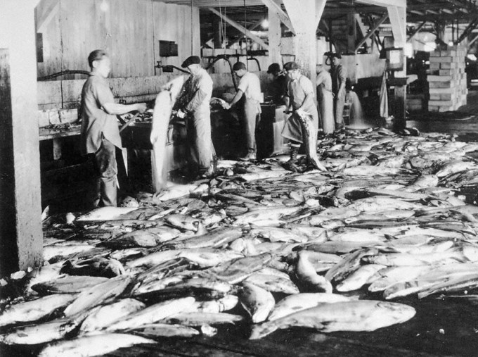
The town thrived back when lumber and fish seemed limitless. Finnish, Swedish, and Norwegian gill-netters worked the river by boat. Calvin Trillin noted in a 1993 New Yorker article, “Astoria’s waterfront was lined with canneries, where the salmon was processed by a contract-labor force so uniformly Chinese that when an automatic fish-skinner was finally invented it was known as an Iron Chink.” The New Yorker has a reputation for meticulous fact-checking, so yes, that is actually what the inventor called it.

lots-of-salmon
2.5 million cans of salmon fill a cannery storeroom in the late 1800s

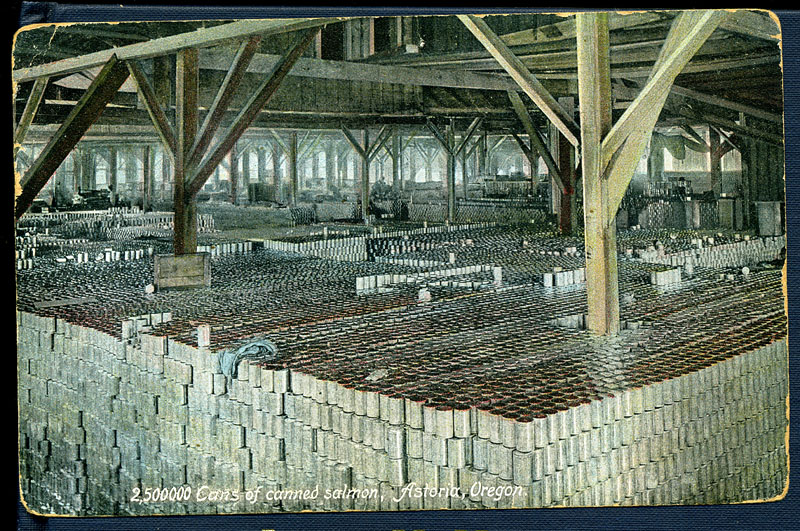
The town eventually boasted 22 canneries for chinook, coho, and sockeye salmon as well as steelhead trout. Over time, several Astoria canneries consolidated into what became the world headquarters of Bumble Bee Seafoods. In the 1960s Bumble Bee was the largest salmon-canning company in the world.

The town’s population peaked at 25,000 during World War II. After that, improved dredging of the Columbia shifted a lot of port business upriver towards Portland. The fish declined as well; locals noted drops in the fish runs as early as the 1870s, and years of upstream pollution, loss of spawning habitat, heavy fishing, and migration-blocking dams further reduced the salmon runs. Bumble Bee closed shop and moved to California in 1980, soon to be engulfed in buyouts, sales, and bankruptcy.

Commercial fishing, logging, and shipping still contribute to the Astoria economy but nowhere near the historic levels. The town has a variety of historic homes and has become a tourist destination with many museums and shops.

Blue heron

Wendy and I had planned for a couple of rhyming laundry stops along the trip: Astoria and Victoria. So we made use of a washer and dryer at the Cannery Pier Hotel the night we arrived in Astoria. We remained at the hotel the next morning. The occasional rumble of a passing ship and the sounds of sea birds reminded us we were far from the cross timbers and prairies of home. I watched the commercial fishing vessel Katrina go by while a blue heron fished the shallows near our room.

We finally roused ourselves to walk a half mile along the riverside trolley tracks for a late lunch at The Ship Inn. I enjoyed my fish and chips despite the restaurant smelling damp and briny. Rocks piled along the shore had been dumped years before by old sailing ships as they entered the Columbia, picking up sealed and canned salmon. A boiler on a concrete piling and a short forest of worn wood pilings were all that remained of a nearby shoreline cannery.

We saw the San Pablo trolling boat pass by and then the much larger Macaru Arrow cargo ship. The Coral Opal and Bulk Bolivia cargo ships were anchored out in the river.

Trolley

As we walked back along the trolley line, its 1913 trolley car rolled by. The trolley uses former freight railroad tracks and has been operating since 1999. Wendy and I enjoyed the signage on a trolley bridge warning bicyclists they could take a tumble if they weren’t careful.

Bicycle Warning

The day was chilly and gray as we stopped to view the many plaques at the Maritime Memorial Park by the river. The memorial is for those who lived and/or died in relation to the water, and the plaques are fascinating.

Mary Boyle “caught the big ones”, and we learned they called Gene Miner “Do-Do”. Scott Arnold was a “commercial fisherman died helping another”, Nancy McClain was “lost at sea” when she was about 21, and as for Big John Viuhkola, “The sea he loved claimed him.”

Maritime Memorial Plaques with Flowers

A long inscription wrote of the allure and danger of the sea:

Weep not for me that I go to sea.
I shan’t be lonely, though vastness surround me.
The brotherhood of the sea shall be my family.
The kinship of the deep my company.

Weep not for me, nor worry over harm.
My heart stays with you, still and warm.
In sunrise and starlight my hearth and home
I carry you with me wherever I roam.

Weep not for me, whether bad luck or good.
Tossed about in a shell of steel and wood.
An ancient salt sea sails within my blood –
I but follow its tide through ebb and flood.

Weep not for me that I go to sea:
in the limitless ocean I am free.

Aries Leader glides past our hotel room

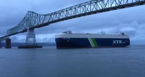
During our stay Wendy came to love looking up passing vessels on marinetraffic.com to learn where they were from, where they were bound, and what they carried. It was relaxing to watch the huge cargo ships slowly hum their way downriver past our balcony. I shot some video of the Aries Leader, a ship carrying automobiles in its hold, as it rumbled past.

For dinner we drove over to T. Paul’s Supper Club, where Wendy delighted in the tender and flavorful salmon and vegetables, commenting that “they really know how to season.” We ended our day with a trip across Youngs Bay for supplies at the local Fred Meyer, an immense one-stop shop. Fred opened his first store in Portland in 1922, and his stores now average 150,000 square feet and carry more than 225,000 items.

We had another full day in Astoria ahead of us, time enough to delve into local history by visiting a nearby mansion and the maritime museum.

SLIDESHOW | PHOTO ALBUM

Honeymoon Day 7: Flavels and Travels in Astoria >

< Honeymoon Day 5: To the Oregon Coast | Other Honeymoon Posts 

Posted in photos, travel | Leave a comment

Honeymoon Day 5: To the Oregon Coast

TRIP DATE: July 6, 2016 | SLIDESHOW | PHOTO ALBUM | Other Honeymoon Posts

Meador Post

After four days in Portland, we were ready to head northwest to the Oregon Coast. We checked out of the hotel in Troutdale, stopped by the local Wal-Mart for beach shoes, and had breakfast at a Shari’s. Then we drove 85 miles through the forests of the Coast Range mountains to reach the coast at Ecola State Park just north of Cannon Beach.

Haystack Rock

Views from Ecola Point

We drove along the narrow winding road in the park to reach a viewpoint I recalled from my first visit a decade earlier: a view south of Crescent Beach from Ecola Point. The parking lot was packed with folks milling about the hillside. To the north was a trailhead that I knew eventually reached the spot from which I had hiked 13 miles back in 2009 to Seaside and back.

I knew the viewpoint was to the south, so we walked over to that side of the hill. Sadly the hillside had eroded so much that the trail to the former viewpoint was closed in December 2015. We could still see Crescent Beach, Haystack Rock, and the Coastal Range, but I was disappointed we could not get closer to the beach.

Crescent Beach from Ecola Point
Tillamook Rock Light

I knew Wendy wanted to walk on the beach, not just take in panoramas, so I led us down various trails, but none led down to Crescent Beach. Later I found online directions that might have led us down to this secluded beach, but there was no useful signage at the park nor on the map we paid for at the gate. I’m left wondering if they deliberately withhold the information.

We did get a view of Tillamook Rock Light, which I could see pretty well using my Canon camera’s 20x zoom despite it being over a mile offshore. Built in 1880-1881, Terrible Tilly, as it was called, was a dangerous commute for its keepers due to erratic weather conditions. Storms have damaged the lighthouse, shattered the lens, and eroded the rock. The lighthouse was decommissioned in 1957 and is now privately owned and reportedly an unofficial columbarium for the ashes of the deceased. Seems like a rather forlorn and not particularly restful final destination to me.

Cannon Beach

I opted to give up on Crescent Beach and drive us over to Cannon Beach just south of it. I knew that more commercial beach would have a lot more tourists, but at least it would be easily accessible. I’d already read about the limited parking options and took online advice to park at the tiny Les Shirley Park, where we could walk along the north side of Ecola Creek out to the north end of Cannon Beach, away from Haystack Rock farther south where I expected most tourists would be headed.

Cannon Beach Panorama

There were only a few parking spots at the little park, and some were open. So we put on our beach shoes and strolled out along Ecola Creek, with Haystack Rock looming in the distance. We walked over to the ocean, and I shot some video of Haystack Rock to the south. It was bright and sunny, but the cold waves reminded Wendy and me that we were far from the warm waters of the Gulf. One fellow was out flying a kite; later I would watch a teenager struggle repeatedly and unsuccessfully to get his kite aloft.

Some equestrians rode past us, headed north. Looking that way we could see Chapman Point, which separates Cannon Beach from Crescent Beach, and Tillamook Rock on the far left about 3.5 miles away. I got a nice shot of nearby breakers and seabirds with Tillamook Rock looming in the background.

Beachcombing Wendy
Lizard

Wendy had fun beachcombing, although she was not impressed by all of the little jellyfish lying about. I watched a fellow in a wetsuit trying to surf.

As we made our way north to Chapman Point, we found little volcanoes of sand and sea debris that someone had constructed. There we spotted a lizard amongst the interesting rocks, capturing some video of his movement.

Near Chapman Point Wendy snapped a photo of some discarded earbuds as three boys walked away along the beach to symbolize casting away the trappings of modern life for the simple pleasures of the natural world.

Casting away the trappings of modern life for the simple pleasures of the natural world

We spent about 90 minutes at the beach before our stomachs told us it was time to eat dinner. There was a convenient spigot at the parking lot where we could wash off our feet. We drove about six miles north to Seaside, where we tried to eat at Nonni’s Italian Bistro, but they were closed. So we walked over to Angelina’s for some nice pizza. Then we had only a sixteen mile drive on up the coast to the mouth of the Columbia River at Astoria, where we’d be staying for three nights.

Cannery Pier Hotel at Astoria

We stayed at the Cannery Pier Hotel, which is built on the pilings of the former Union Fish Cannery, 600 feet out into the Columbia River. Our suite there cost twice as much per night as our Best Western at Troutdale: location, location, location!

Sunset from Cannery Pier

While the views from our fancy corner suite were fantastic, Wendy was unimpressed by the lack of air conditioning and an odor in the living room. She traced the smell down, literally, to a rug which someone’s pet had evidently soiled. I hauled the rug out onto the balcony. The next day it was removed by housekeeping, never to return.

Over time we grew accustomed to the sounds of the river coming through the open windows of our suite: the low hum of engines as ships big and small passed by, the occasional scream of a cormorant, and the daytime scouring of the nearby Astoria-Megler Bridge. They are in the seventh year of stripping and repainting that bridge, with the current work shielded by huge covers along a section of roadway and one tower. At over four miles, it is the longest continuous truss bridge in North America, and the renovation work is projected to last through 2021.

Our day closed with a spectacular sunset across the wide mouth of the Columbia River. We’d spend the next two days relaxing in Astoria, the first permanent United States settlement on the Pacific coast.

SLIDESHOW | PHOTO ALBUM

Honeymoon Day 6: Astoria’s Riverfront >

Honeymoon Day 4: Columbia River Gorge | Other Honeymoon Posts

Posted in photos, travel, video | Leave a comment

Honeymoon, Day 4: Columbia River Gorge

TRIP DATE: July 5, 2016 | SLIDESHOW | PHOTO ALBUM | Links to Honeymoon Posts

Meador Post

One of my favorite drives is the Historic Columbia River Highway, which originally ran 70 miles from Troutdale east along the south shore of the Columbia River Gorge to The Dalles. Like Oklahoma’s later Talimena Skyline Drive, this road was built purely for the scenery. Oregon’s highway was built from 1913 to 1922 and featured gentle curves and a few amazing tunnels. Sadly, only the western third remains fully intact, preserved because of the many waterfalls it meanders by while Interstate 84 runs along the riverside below. Farther east, the interstate consumed the old road, leaving only fragments recently revived as hiking trails, until the old road resurfaces from Mosier to The Dalles.

July 5 2016 Travel Map

We headed out from our hotel through downtown Troutdale, following the old road as it turned south to follow the eastern shore of the Sandy River. Just before the road turned east to begin its run towards and along the Columbia River, we had breakfast. We pulled into Shirley’s Tippy Canoe, where we were too late for breakfast. So I enjoyed delicious fish and chips while Wendy had a burger that she found too thick for her liking.

From there we headed to Vista House, a fabulous viewpoint above the Columbia River. I forgot to turn off at the Portland Women’s Forum for a great view I’d seen on earlier trips of Vista House above the river, but Wendy was still struck by the appearance of the house when we reached its perch 733 feet above the Columbia. The architect, Edgar M. Lazarus, called it “a temple to the natural beauty of the Gorge”. We stopped and looked around inside and up on the viewing deck.

Vista House Panorama

Our next stop was Bridal Veil Falls, a spot I had previously visited a decade before. We parked at the busy lot and walked the trail over to the falls. A steady stream of tourists walked along the creek and were enjoying the view of the double falls, with some gathered at its base and venturing into the pool. We took a selfie, I shot some video, and Wendy enjoyed looking at the rocks.

Multnomah Falls, the most famous waterfall along the highway, was only three miles eastward. Soon after leaving Bridal Veil we hit a traffic jam on the two-lane highway. We crawled for the better part of an hour along the road to finally reach Multnomah, which was completely overrun with holiday tourists. Some folks disregarded warning signs and walked beside the creeping cars with little room for error. One silly lady almost stuck her head in the passenger window of our car as she yelled, “Hi!” Wendy and I were unimpressed.

When we finally reached the falls, we weren’t interested in joining the throng, so Wendy just snapped a photo as we passed by. I’d hiked up to the famous bridge on a previous visit and remembered how crowded the trail was back then; there were even more people present this time around. Soon after passing through the parking area we finally cleared the jam. At Dodson this segment of the old highway was consumed into Interstate 84.

Before reaching Hood River, we turned off the interstate to see Mitchell Point. Before the scenic road was destroyed, there was a tunnel here with many windows looking out over the Columbia. The rock here is very fragmented and unstable, so it is not too surprising that the tunnel did not last. We raced along to Hood River, where we turned off the road and headed south to a spot I hadn’t visited before: Panorama Point County Park and Viewpoint. From there we could view 15,000 acres of orchards and vineyards as we gazed south towards Mount Hood.

Panorama Point

I tried to continue eastward on the Old Dalles Road, which maps claimed would link to the Hood River Road to Mosier. But the Hood River Road turned out to be gated off and suitable for 4-wheelers, not a rental car. So we returned to Interstate 84. The diversion was not wasted however, as Wendy got a splendid shot of the orchards and Mount Hood from Old Dalles Road.

Orchards and Vineyards below Mount Hood
Memaloose Island

At Mosier we were able to get back on the historic scenic road for the drive east to Rowena and The Dalles. We stopped at the Memaloose Overlook for another panoramic view of the Columbia. Below and east in the river was Memaloose Island, one of several “islands of the dead” once found in the Columbia. At one time, the Native Americans here did not bury their dead. Instead they wrapped them in robes or mats and deposited them in canoes which were placed in the woods, on rocky points, or in cedar vaults on islands like Memaloose. The word is derived from the Chinook memalust which means “to die”, although Lewis and Clark named it Sepulcher Island in 1805 and visited it in 1806. The only visible monument on the island marks the grave of Victor Trevitt, a pioneer printer, businessman, legislator, and friend of the Indians. He asked to be buried here among them. When the Bonneville Dam flooded the area in the 1930s, the Indian graves were relocated. So today only Victor’s grave remains.

Our last scenic stop was Rowena Crest for a wonderful view of the Columbia. I love the golden color of the hills on the north side of the river there as one leaves the coastal greenery and enters the rain shadow of the Cascade Mountains. It is striking to see in satellite views of Oregon the division between the wet lands west of the mountains and the dry lands to the east. The little town of Lyle, Washington is nestled there on the north side of the river along the Klickitat River. On either side are the tall vertical cliffs the Columbia River gouged through the Rowena Gap basalts via periodic and catastrophic Missoula floods at the end of the last ice age.

Lyle, Washington
Rowena Loops

The unrealized engineer in me marveled at the Rowena Loops just below the crest. Engineer Samuel Lancaster originally designed the Columbia River Highway to have maximum grades of 5% and gentle curves with radii of 200 feet or more. J.H. Scott followed that design principle when laying out the road at Rowena, using multiple winding curves to negotiate the route down from Rowena Crest to the river. The road looks like a snake twisting in on itself, but the drive is quite pleasant.

We ended our journey east in The Dalles at Cousins’ Restaurant. I enjoyed some down home turkey and dressing, but Wendy found her pot roast was a bit dry.

Our return to Troutdale was a dash down I-84 for our final night at the Cascades Inn. The next day we would make our way to the coast to visit Cannon Beach and Seaside.

SLIDESHOW | PHOTO ALBUM

Day 5: To the Oregon Coast >

< Honeymoon Roses | Other Honeymoon Posts

Posted in day hike, photos, travel, video | Leave a comment

Here are the blog posts thus far about our honeymoon in July 2016; more to come!

  1. Keeping it Simple
  2. Day 1: Planning for Portland and Beyond
  3. Day 2: Downtown Portlandia
  4. Day 3: International Rose Test Garden
  5. Honeymoon Roses
  6. Day 4: Columbia River Gorge
  7. Day 5: To the Oregon Coast
  8. Day 6: Astoria’s Riverfront
  9. Day 7: Flavels and Travels in Astoria
  10. Day 8: Mount St. Helens
  11. Day 9: Tacoma Glass
  12. Day 10: Ruby Beach
  13. Day 11: To Canada from the Port of the Angels
  14. Day 12: A Walk in Victoria
  15. Day 13: Art & Butchart

honeymoon-map

Posted on by Granger Meador | Leave a comment

Time for a Refresh

Recently I decided the MEADOR.ORG website’s appearance needed a refresh. I don’t change the website’s appearance on a whim. This would only be the sixth change in its general appearance in the twenty years MEADOR.ORG has been online.

But I’d been using the Choco theme since 2011, and its stitched leather folio look was skeuomorphic, something Apple famously abandoned in 2013. Even staid Microsoft shifted to flat design with Windows 8 back in 2012. I like Sacha Greif’s take on the design changes we’re seeing across computing platforms.

2011-blog-design

MEADOR.ORG used the WordPress.com Choco theme from March 2011 to November 2016

I’d also noticed how many websites were now using large images to introduce themselves and their stories, which Jake Rocheleau calls the Hero Image Trend. Given the preponderance and popularity of travel posts and their accompanying photographs at MEADOR.ORG, it made sense to start using a large header image and make use of the “Featured Image” option at WordPress.com to customize that header image for individual posts, while randomizing the header image for the long scroll of the default homepage.

So I began searching for a new theme. This blog has been hosted at WordPress.com since 2008, and that service has a slew of choices. Thankfully they let you try out a new theme on your blog, tweaking the settings to see how it all fits together, before imposing it on the published site. Plus they now have some pretty nice filters to search for themes with specific features. That let me quickly narrow down my choices: I wanted to keep the format of a single wide column for posts with a right sidebar for widgets for recent posts, tags, etc. while supporting a large header image and posts with a Featured Image.

2016-11-blog-redesign

The customized Twenty ten theme applied to MEADOR.ORG

I actually stepped back in time for my choice of the Twenty ten theme, which was the default theme for WordPress.com posts back in 2010. It met all of my criteria and had the bonus feature of allowing me to randomize the header image that would appear when loading a page (versus a specific post).

headers

When viewing a page instead of a particular post, the site now loads any of over 75 different header images drawn from the photographs I’ve taken for my travelogues

I uploaded over 75 panoramas from my library of photos I’ve taken on my day hikes since 2009, cropping them to fit the header image proportions. Now a random selection from a collection of my favorite panoramas will greet visitors to the home page and older posts.

Now I can upload and crop a photo to the ratio of 940 x 198 and designate it as the header image for a particular post. I’ll do that for most new posts, since my Facebook page and its cross-posting to Twitter drives most of the traffic to individual posts on our website.

My posts are text-heavy, so I paid attention to that as well. At first I tried Merriweather Sans, but eventually opted to use the Merriweather serif font, which has a large x height.

For headers, I tried almost every available font before settling on the largest size of Fondamento. I liked how it resembled calligraphy. Its uneven strokes are not good for small font sizes, making it problematic for the small date headings I’d been putting on my posts. So I’ll now use a larger size for any date header and the PHOTO ALBUM | SLIDESHOW header links I include on travelogues.

UPDATE: In July 2017, tired of watching the screen load with the default fonts and then redraw with my selections, so I gave up and used the default fonts in this theme.

I can’t predict how long this new look will last, but it seems fresh and engaging. I expect the big header images will sustain this choice for some time.

blog-designs

This is the sixth “look” for the website in its 20 years of existence

Posted in technology, web design | Leave a comment